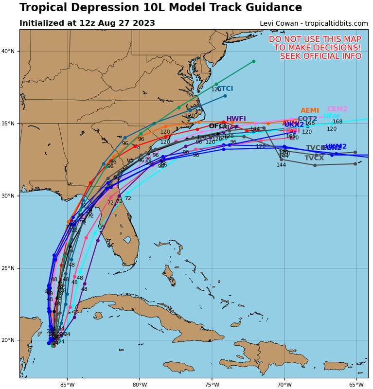
ATL: IDALIA - Models

Moderator: S2k Moderators

Message
Author
Nuno
Category 2
Category 2
Posts: 591
Joined: Fri Aug 30, 2019 8:35 am
Location: Coral Gables, FL

Re: ATL: TEN - Models

#361 Postby Nuno » Sun Aug 27, 2023 9:07 am

jlauderdal wrote:
boca wrote:
jlauderdal wrote:Expect further track changes until this thing starts moving..remember the angle of approach makes big swings even more likely..a little to the right, little the left, little to the south makes the long term track very low confidence right now and the action is on the right side as usual


South Florida shouldn’t let their guard down either.

Correct, we have to see how intense it gets and of course track....its all about the feeder bands and where they setup for us


Thankfully we will be far from any core but like Ian, those feeder bands that day before landfall was the worst weather we've seen from a tropical system since Irma. Going to be a tricky day for the whole state given it'll be business as usual for school and work but in miserable enough conditions. I'm worried for the west coasters about this really ramping up.
1 likes   
Andrew (1992), Irene (1999), Frances (2004), Katrina (2005), Wilma (2005), Fay (2008), Irma (2017), Eta (2020), Ian (2022)

User avatar
Spacecoast
Category 2
Category 2
Posts: 758
Joined: Thu Aug 31, 2017 2:03 pm

Re: ATL: TEN - Models

#362 Postby Spacecoast » Sun Aug 27, 2023 9:10 am

06z EPS:
Image

Closeup of 1st 48hrs...
Image
Last edited by Spacecoast on Sun Aug 27, 2023 9:17 am, edited 1 time in total.
1 likes   

User avatar
NDG
S2K Supporter
S2K Supporter
Posts: 15446
Joined: Sun Jul 09, 2006 10:14 pm
Location: Orlando, FL

Re: ATL: TEN - Models

#363 Postby NDG » Sun Aug 27, 2023 9:11 am

06z Euro, nice job on the current cyclonic loop that it has been doing since last night.

Image
3 likes   

skillz305
Category 1
Category 1
Posts: 277
Joined: Sat Sep 08, 2018 11:10 am
Location: Miami, Florida --> Vero Beach, Florida

Re: ATL: TEN - Models

#364 Postby skillz305 » Sun Aug 27, 2023 9:17 am

Updated 12z Track Guidance

Image
0 likes   
:flag:Hurricanes: Andrew 1992 - Irene 1999 - Frances 2004 - Jeanne 2004 - Katrina 2005 - Wilma 2005 - Matthew 2016 - Irma 2017 - Ian 2022 - Nicole 2022

User avatar
gatorcane
S2K Supporter
S2K Supporter
Posts: 23689
Age: 47
Joined: Sun Mar 13, 2005 3:54 pm
Location: Boca Raton, FL

Re: ATL: TEN - Models

#365 Postby gatorcane » Sun Aug 27, 2023 9:36 am

06Z HWRF with a pronounced NNE track out of the Caribbean:

Image
0 likes   

User avatar
syfr
S2K Supporter
S2K Supporter
Posts: 169
Age: 106
Joined: Fri Oct 26, 2012 7:33 pm
Location: East Central NC

Re: ATL: TEN - Models

#366 Postby syfr » Sun Aug 27, 2023 9:53 am

The models do seem to be converging, and I have to believe that the fact that the storm is basically stationary at the moment , is not helping the prediction efforts.
0 likes   
I'm not a meteorologist, I'm an electronics engineer. While I can probably fix your toaster oven, you're not going to learn about storms from me!

New Mexico had no hurricanes. Then I moved to NC right before Fran.....

LandoWill
Tropical Storm
Tropical Storm
Posts: 154
Joined: Sun Sep 25, 2022 10:25 pm

Re: ATL: TEN - Models

#367 Postby LandoWill » Sun Aug 27, 2023 10:04 am

I am confused why tampa is out of the cone completely and their "cone" guidance is more west than what these graphics I've been seeing shows?
0 likes   

User avatar
Gums
S2K Supporter
S2K Supporter
Posts: 169
Age: 82
Joined: Sun Oct 07, 2018 7:30 pm
Location: Niceville, FL

Re: ATL: TEN - Models

#368 Postby Gums » Sun Aug 27, 2023 10:04 am

Salute!

Well, if the storm moves slowly, the basic cold front coming in 3 days will help a bunch..have seen it too many times down here in the Panhandle.

Still, looks like Cedar Key, Steinhatchee and maybe Crystal River will take the worst, and do not rule out a sharp turn and head for Tampa. We should know if it makes the eastward turn by Monday night.

Gums sends...
1 likes   

tolakram
Admin
Admin
Posts: 19990
Age: 61
Joined: Sun Aug 27, 2006 8:23 pm
Location: Florence, KY (name is Mark)

Re: ATL: TEN - Models

#369 Postby tolakram » Sun Aug 27, 2023 10:06 am

LandoWill wrote:I am confused why tampa is out of the cone completely and their "cone" guidance is more west than what these graphics I've been seeing shows?
The cone is simply circles around each forecast point. If the forecast points move the cone will move. The size of each circle is set at the beginning of each year based on average forecast error.
0 likes   
M a r k
- - - - -
Join us in chat: Storm2K Chatroom Invite. Android and IOS apps also available.

The posts in this forum are NOT official forecasts and should not be used as such. Posts are NOT endorsed by any professional institution or STORM2K.org. For official information and forecasts, please refer to NHC and NWS products.

caneman
Category 5
Category 5
Posts: 1446
Joined: Fri Sep 05, 2014 5:44 am
Location: Clearwater Beach, Fl

Re: ATL: TEN - Models

#370 Postby caneman » Sun Aug 27, 2023 10:10 am

LandoWill wrote:I am confused why tampa is out of the cone completely and their "cone" guidance is more west than what these graphics I've been seeing shows?


Dont get hung on that. If it comes to Crystal river it may as well be a Tampa Bay area hit due angle of approach and how close it will be to us
Last edited by caneman on Sun Aug 27, 2023 10:18 am, edited 1 time in total.
0 likes   

psyclone
S2K Supporter
S2K Supporter
Posts: 4745
Joined: Wed Aug 24, 2005 9:04 pm
Location: palm harbor fl

Re: ATL: TEN - Models

#371 Postby psyclone » Sun Aug 27, 2023 10:11 am

tolakram wrote:
LandoWill wrote:I am confused why tampa is out of the cone completely and their "cone" guidance is more west than what these graphics I've been seeing shows?
The cone is simply circles around each forecast point. If the forecast points move the cone will move. The size of each circle is set at the beginning of each year based on average forecast error.


Forget the cone and look at wind probs. Tampa's have been marching relentlessly higher with each advisory. The absolute number along with trend lines represent the best way to assess risk in a given region at this early juncture.
3 likes   

User avatar
CronkPSU
S2K Supporter
S2K Supporter
Posts: 2014
Joined: Sun Aug 07, 2005 10:44 pm
Location: Avalon Park, FL

Re: ATL: TEN - Models

#372 Postby CronkPSU » Sun Aug 27, 2023 10:15 am

discussions says the cone did move east

" The official forecast track has been nudged to the right of the
previous one, but is not quite as far east as the latest corrected
consensus, HCCA, prediction."
3 likes   
Just like Jon Snow..."I know nothing" except what I know, and most of what I know is gathered by the fine people of the NHC

LandoWill
Tropical Storm
Tropical Storm
Posts: 154
Joined: Sun Sep 25, 2022 10:25 pm

Re: ATL: TEN - Models

#373 Postby LandoWill » Sun Aug 27, 2023 10:23 am

CronkPSU wrote:discussions says the cone did move east

" The official forecast track has been nudged to the right of the
previous one, but is not quite as far east as the latest corrected
consensus, HCCA, prediction."

Yeah they did on the new one.. sigh
0 likes   

Ianswfl
Category 1
Category 1
Posts: 482
Joined: Thu Mar 23, 2023 11:11 pm

Re: ATL: IDALIA - Models

#374 Postby Ianswfl » Sun Aug 27, 2023 10:24 am

Icon shifted south about 15 miles at 12z
1 likes   

tolakram
Admin
Admin
Posts: 19990
Age: 61
Joined: Sun Aug 27, 2006 8:23 pm
Location: Florence, KY (name is Mark)

Re: ATL: IDALIA - Models

#375 Postby tolakram » Sun Aug 27, 2023 10:38 am

GFS 12Z Started

Image
0 likes   
M a r k
- - - - -
Join us in chat: Storm2K Chatroom Invite. Android and IOS apps also available.

The posts in this forum are NOT official forecasts and should not be used as such. Posts are NOT endorsed by any professional institution or STORM2K.org. For official information and forecasts, please refer to NHC and NWS products.

tolakram
Admin
Admin
Posts: 19990
Age: 61
Joined: Sun Aug 27, 2006 8:23 pm
Location: Florence, KY (name is Mark)

Re: ATL: IDALIA - Models

#376 Postby tolakram » Sun Aug 27, 2023 10:39 am

East
Image
0 likes   
M a r k
- - - - -
Join us in chat: Storm2K Chatroom Invite. Android and IOS apps also available.

The posts in this forum are NOT official forecasts and should not be used as such. Posts are NOT endorsed by any professional institution or STORM2K.org. For official information and forecasts, please refer to NHC and NWS products.

jlauderdal
S2K Supporter
S2K Supporter
Posts: 7177
Joined: Wed May 19, 2004 5:46 am
Location: NE Fort Lauderdale
Contact:

Re: RE: Re: ATL: IDALIA - Models

#377 Postby jlauderdal » Sun Aug 27, 2023 10:41 am

tolakram wrote:East
Image
Tampa folks caught a break on ian, this setup doesnt look good for them.
0 likes   

tolakram
Admin
Admin
Posts: 19990
Age: 61
Joined: Sun Aug 27, 2006 8:23 pm
Location: Florence, KY (name is Mark)

Re: ATL: IDALIA - Models

#378 Postby tolakram » Sun Aug 27, 2023 10:43 am

Image
0 likes   
M a r k
- - - - -
Join us in chat: Storm2K Chatroom Invite. Android and IOS apps also available.

The posts in this forum are NOT official forecasts and should not be used as such. Posts are NOT endorsed by any professional institution or STORM2K.org. For official information and forecasts, please refer to NHC and NWS products.

User avatar
Woofde
Category 1
Category 1
Posts: 475
Joined: Tue Jul 06, 2021 11:33 am

Re: ATL: IDALIA - Models

#379 Postby Woofde » Sun Aug 27, 2023 10:44 am

Franklin is noticeably weaker thus far on this GFS run.
0 likes   

floridasun
Tropical Storm
Tropical Storm
Posts: 196
Joined: Tue Sep 14, 2021 3:59 pm

Re: ATL: IDALIA - Models

#380 Postby floridasun » Sun Aug 27, 2023 10:44 am

so you think nhc will keep cone same or move it more to south close to sw fl?
0 likes   


Return to “2023”

Who is online

Users browsing this forum: No registered users and 28 guests