ATL: IDALIA - Post-Tropical - Discussion
Moderator: S2k Moderators
-
cheezyWXguy

- Category 5

- Posts: 6282
- Joined: Mon Feb 13, 2006 12:29 am
- Location: Dallas, TX
Re: ATL: IDALIA - Tropical Storm - Discussion
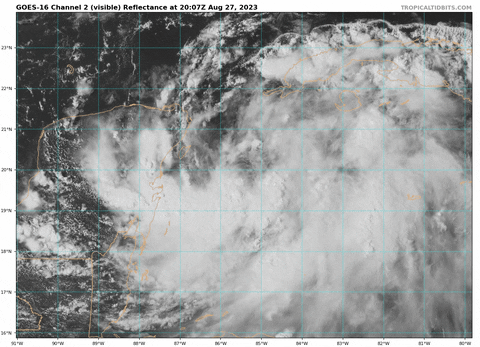
Large convective bursts either over or just south of the circulation center
3 likes

Re: ATL: IDALIA - Tropical Storm - Discussion
Much of Florida may be affected by Idalia, but look at S E Florida sitting there smiling in the sun.
0 likes
-
tolakram
- Admin

- Posts: 20180
- Age: 62
- Joined: Sun Aug 27, 2006 8:23 pm
- Location: Florence, KY (name is Mark)
Re: ATL: IDALIA - Tropical Storm - Discussion
...STORM SURGE AND HURRICANE WATCHES ISSUED FOR PORTIONS OF THE FLORIDA GULF COAST...
000
WTNT35 KNHC 272050
TCPAT5
BULLETIN
Tropical Storm Idalia Advisory Number 5
NWS National Hurricane Center Miami FL AL102023
400 PM CDT Sun Aug 27 2023
...STORM SURGE AND HURRICANE WATCHES ISSUED FOR PORTIONS OF THE
FLORIDA GULF COAST...
SUMMARY OF 400 PM CDT...2100 UTC...INFORMATION
----------------------------------------------
LOCATION...20.1N 85.5W
ABOUT 95 MI...155 KM ESE OF COZUMEL MEXICO
MAXIMUM SUSTAINED WINDS...40 MPH...65 KM/H
PRESENT MOVEMENT...NE OR 40 DEGREES AT 3 MPH...6 KM/H
MINIMUM CENTRAL PRESSURE...995 MB...29.39 INCHES
WATCHES AND WARNINGS
--------------------
CHANGES WITH THIS ADVISORY:
A Storm Surge Watch has been issued for the Gulf coast of Florida
from Chokoloskee to Indian Pass, including Tampa Bay.
A Hurricane Watch has been issued for the Gulf coast of Florida
from Englewood to Indian Pass, including Tampa Bay.
A Tropical Storm Watch has been issued for the Gulf coast of
Florida south of Englewood to Chokoloskee, and for the Dry Tortugas.
SUMMARY OF WATCHES AND WARNINGS IN EFFECT:
A Tropical Storm Warning is in effect for...
* Yucatan Peninsula from Tulum to Rio Lagartos, including Cozumel
* Pinar del Rio Cuba
A Storm Surge Watch is in effect for...
* Chokoloskee to Indian Pass Florida, including Tampa Bay
A Hurricane Watch is in effect for...
* Englewood to Indian Pass Florida, including Tampa Bay
A Tropical Storm Watch is in effect for...
* Isle of Youth Cuba
* South of Englewood to Chokoloskee Florida
* Dry Tortugas Florida
A Storm Surge Watch means there is a possibility of life-
threatening inundation, from rising water moving inland from the
coastline, in the indicated locations during the next 48 hours.
For a depiction of areas at risk, please see the National Weather
Service Storm Surge Watch/Warning Graphic, available at
hurricanes.gov.
A Hurricane Watch means that hurricane conditions are possible
within the watch area. A watch is typically issued 48 hours
before the anticipated first occurrence of tropical-storm-force
winds, conditions that make outside preparations difficult or
dangerous.
A Tropical Storm Warning means that tropical storm conditions are
expected somewhere within the warning area.
A Tropical Storm Watch means that tropical storm conditions are
possible within the watch area.
Interests along the southeastern U.S. coast should monitor the
progress of this system. Additional watches and warnings will
likely be required on Monday.
For storm information specific to your area, please monitor
products issued by your national meteorological service.
DISCUSSION AND OUTLOOK
----------------------
At 400 PM CDT (2100 UTC), the center of Tropical Storm Idalia was
located near latitude 20.1 North, longitude 85.5 West. Idalia is
moving toward the northeast near 3 mph (6 km/h). A slow, possibly
erratic, motion is expected overnight. A generally northward to
north-northeastward motion at an increasing forward speed is
expected on Monday and Tuesday. On the forecast track, the center
will move over the eastern Gulf of Mexico on Monday and Tuesday,
and approach the northeast Gulf coast late Tuesday.
Maximum sustained winds are near 40 mph (65 km/h) with higher gusts.
Strengthening is forecast, and Idalia is expected to become a
hurricane over the southeastern Gulf of Mexico by early Tuesday.
Additional strengthening is likely while Idalia approaches the
northeastern Gulf coast.
Tropical-storm-force winds extend outward up to 70 miles (110 km)
from the center.
The estimated minimum central pressure is 995 mb (29.39 inches).
HAZARDS AFFECTING LAND
----------------------
Key messages for Idalia can be found in the Tropical Cyclone
Discussion under AWIPS header MIATCDAT5 and WMO header WTNT45 KNHC,
and on the web at hurricanes.gov/text/MIATCDAT5.shtml
STORM SURGE: The combination of a dangerous storm surge and the
tide will cause normally dry areas near the coast to be flooded by
rising waters moving inland from the shoreline. The water could
reach the following heights above ground somewhere in the indicated
areas if the peak surge occurs at the time of high tide...
Aucilla River, FL to Chassahowitzka, FL...7-11 ft
Chassahowitzka, FL to Anclote River, FL...5-8 ft
Ochlockonee River, FL to Aucilla River, FL...4-7 ft
Anclote River, FL to Middle of Longboat Key, FL...3-5 ft
Tampa Bay...3-5 ft
Middle of Longboat Key, FL to Chokoloskee, FL...2-4 ft
Charlotte Harbor...2-4 ft
Indian Pass, FL to Ochlockonee River, FL...2-4 ft
Chokoloskee, FL to East Cape Sable, FL...1-3 ft
Florida Keys...1-2 ft
The deepest water will occur along the immediate coast in areas of
onshore winds, where the surge will be accompanied by large and
dangerous waves. Surge-related flooding depends on the relative
timing of the surge and the tidal cycle, and can vary greatly over
short distances. For information specific to your area, please see
products issued by your local National Weather Service forecast
office.
Storm surge will raise water levels by as much as 2 to 4 feet above
normal tide levels along the southern coast of Pinar del Rio, Cuba.
Near the coast, the surge will be accompanied by
large waves.
WIND: Tropical storm conditions are expected over portions of the
warning area over the Yucatan Peninsula and western Cuba through
Monday. Tropical storm conditions are possible within the watch
area on the Isle of Youth on Monday.
Hurricane conditions are possible within the hurricane watch area by
late Tuesday or Wednesday, with tropical storm conditions possible
by Tuesday.
Tropical storm conditions are possible in the Dry Tortugas beginning
late Monday and within the tropical storm watch area along the
Florida Gulf coast on Tuesday.
RAINFALL: Idalia is expected to produce the following rainfall
amounts:
Portions of the eastern Yucatan Peninsula: 2 to 4 inches, with
isolated higher totals of 6 inches.
Western Cuba: 3 to 6 inches, with isolated higher totals of 10
inches.
Portions of the west coast of Florida, the Florida Panhandle, and
southern Georgia: From Tuesday into Wednesday, 3 to 6 inches, with
isolated higher totals of 10 inches.
Heavy rainfall is also likely to spread into portions of the
Carolinas by Wednesday into Thursday.
This rainfall may lead to flash and urban flooding, and landslides
across western Cuba. Scattered flash and urban flooding can also
be expected across portions of the west coast of Florida, the
Florida Panhandle and portions of the Southeast U.S. by Tuesday
into Thursday.
NEXT ADVISORY
-------------
Next intermediate advisory at 700 PM CDT.
Next complete advisory at 1000 PM CDT.
$$
Forecaster Pasch
0 likes
M a r k
- - - - -
Join us in chat: Storm2K Chatroom Invite. Android and IOS apps also available.
The posts in this forum are NOT official forecasts and should not be used as such. Posts are NOT endorsed by any professional institution or STORM2K.org. For official information and forecasts, please refer to NHC and NWS products.
-
cycloneye

- Admin
- Posts: 149319
- Age: 69
- Joined: Thu Oct 10, 2002 10:54 am
- Location: San Juan, Puerto Rico
Re: ATL: IDALIA - Tropical Storm - Discussion
Here we go with the watches.
A Storm Surge Watch has been issued for the Gulf coast of Florida
from Chokoloskee to Indian Pass, including Tampa Bay.
A Hurricane Watch has been issued for the Gulf coast of Florida
from Englewood to Indian Pass, including Tampa Bay.
A Tropical Storm Watch has been issued for the Gulf coast of
Florida south of Englewood to Chokoloskee, and for the Dry Tortugas.
from Chokoloskee to Indian Pass, including Tampa Bay.
A Hurricane Watch has been issued for the Gulf coast of Florida
from Englewood to Indian Pass, including Tampa Bay.
A Tropical Storm Watch has been issued for the Gulf coast of
Florida south of Englewood to Chokoloskee, and for the Dry Tortugas.
2 likes
Visit the Caribbean-Central America Weather Thread where you can find at first post web cams,radars
and observations from Caribbean basin members Click Here
and observations from Caribbean basin members Click Here

Re: ATL: IDALIA - Tropical Storm - Discussion
This seems updated??
FORECAST VALID 30/0600Z 28.7N 83.7W
MAX WIND 85 KT...GUSTS 105 KT.
50 KT... 50NE 50SE 20SW 20NW.
34 KT...110NE 150SE 70SW 70NW.
FORECAST VALID 30/0600Z 28.7N 83.7W
MAX WIND 85 KT...GUSTS 105 KT.
50 KT... 50NE 50SE 20SW 20NW.
34 KT...110NE 150SE 70SW 70NW.
2 likes
Andy D
(For official information, please refer to the NHC and NWS products.)
(For official information, please refer to the NHC and NWS products.)
-
johngaltfla

- Category 5
- Posts: 2073
- Joined: Sun Jul 10, 2005 9:17 pm
- Location: Sarasota County, FL
- Contact:
Re: ATL: IDALIA - Tropical Storm - Discussion
cycloneye wrote:Here we go with the watches.A Storm Surge Watch has been issued for the Gulf coast of Florida
from Chokoloskee to Indian Pass, including Tampa Bay.
A Hurricane Watch has been issued for the Gulf coast of Florida
from Englewood to Indian Pass, including Tampa Bay.
A Tropical Storm Watch has been issued for the Gulf coast of
Florida south of Englewood to Chokoloskee, and for the Dry Tortugas.

4 likes

Re: ATL: IDALIA - Tropical Storm - Discussion
Anyone else staying up for the 2 am Euro? Seems forever since I endured one of those nights. Some of the Hi Res model runs remind me of Andrew. Small and compact can greatly lesson widespread damage but anyone getting the eye could be in serious trouble if this bombs all the way until landfall. Others showed a much broader wind field. My preps started last week so I have the time to wait for tomorrows track and intensity estimates before getting concerned. My main worry is power loss due to wind speed and the rocking motion that occurs when riding up against a cold front. At least it is not an October front! Generator was fired up last Sunday and gas was stored Monday, well in advance so we will be ready.
Last edited by sponger on Sun Aug 27, 2023 4:12 pm, edited 1 time in total.
5 likes
The following post is NOT an official forecast and should not be used as such. It is just the opinion of the poster and may or may not be backed by sound meteorological data. It is NOT endorsed by any professional institution including storm2k.org For Official Information please refer to the NHC and NWS products.
Re: ATL: IDALIA - Tropical Storm - Discussion
chaser1 wrote:This seems updated??
FORECAST VALID 30/0600Z 28.7N 83.7W
MAX WIND 85 KT...GUSTS 105 KT.
50 KT... 50NE 50SE 20SW 20NW.
34 KT...110NE 150SE 70SW 70NW.
Not surprised.
0 likes
The following post is NOT an official forecast and should not be used as such. It is just the opinion of the poster and may or may not be backed by sound meteorological data. It is NOT endorsed by any professional institution including storm2k.org For Official Information please refer to the NHC and NWS products.

Re: ATL: IDALIA - Tropical Storm - Discussion
from the 5PM discussion...
When the system moves into the northeast Gulf
of Mexico, a mid-level trough developing over the eastern United
states will likely cause Idalia to turn northeastward with an
increase in forward speed. The new official forecast is again
shifted slightly eastward, and is somewhat faster than the previous
one. This is a blend of the latest ECMWF and GFS solutions and is
also between the simple and corrected dynamical consensus tracks.
The intensity forecast is somewhat challenging. Idalia will be
traversing eastern Gulf of Mexico waters of high oceanic heat
content, and the environmental air mass should remain fairly moist.
The flow to the east of an upper-level trough could impart some
vertical wind shear over the system, but this shear could also be
compensated by the conducive effect of upper-level diffluence.
There is considerable spread in the model intensity guidance,
ranging from minimal to major hurricane status before landfall on
the northeast Gulf coast. The official intensity forecast is a
little higher than the previous one, and remains near the higher
end of the guidance. Given the uncertainties, users should monitor
future NHC forecasts for possible changes in the predicted strength
of Idalia, and prepare for possible significant impacts within the
hurricane and storm surge watch areas.
0 likes
Just like Jon Snow..."I know nothing" except what I know, and most of what I know is gathered by the fine people of the NHC
Re: ATL: IDALIA - Tropical Storm - Discussion
chaser1 wrote:This seems updated??
FORECAST VALID 30/0600Z 28.7N 83.7W
MAX WIND 85 KT...GUSTS 105 KT.
50 KT... 50NE 50SE 20SW 20NW.
34 KT...110NE 150SE 70SW 70NW.
Peak intensity increased from 80 kt to 85 kt.
0 likes
-
jaguars_22
- Category 2

- Posts: 629
- Joined: Tue Jun 20, 2017 2:26 pm
- Location: Victoria TX
Re: ATL: IDALIA - Tropical Storm - Discussion
Anyone else see the mini spin in BoC? Smallest disturbance ever 
0 likes
-
MarioProtVI
- Category 5
- Posts: 1034
- Age: 24
- Joined: Sun Sep 29, 2019 7:33 pm
- Location: New Jersey
Re: ATL: IDALIA - Tropical Storm - Discussion


The amount of parallels this is copying from Michael is scary…Michael’s 5th advisory (also at 5pm on a Sunday) was the first to have C2 in the cone, just like it is with Idalia…the looks are even identical..
4 likes
-
SFLcane

- S2K Supporter

- Posts: 10281
- Age: 48
- Joined: Sat Jun 05, 2010 1:44 pm
- Location: Lake Worth Florida
Re: ATL: IDALIA - Tropical Storm - Discussion
Just a bit a bit of uncertainty? Huge area under a hurricane watch almost to fort Myers
4 likes
Re: ATL: IDALIA - Tropical Storm - Discussion
MarioProtVI wrote:https://media.discordapp.net/attachments/708882878406197310/1145464785111101630/image0.jpg https://media.discordapp.net/attachments/708882878406197310/1145464785471815720/image1.jpg
The amount of parallels this is copying from Michael is scary…Michael’s 5th advisory (also at 5pm on a Sunday) was the first to have C2 in the cone, just like it is with Idalia…the looks are even identical..
I will never forget watching Brett Adair fail to intercept in Mexico Beach, saving his life. Watching his empty abandoned truck fill with water was terrifying.
2 likes
The following post is NOT an official forecast and should not be used as such. It is just the opinion of the poster and may or may not be backed by sound meteorological data. It is NOT endorsed by any professional institution including storm2k.org For Official Information please refer to the NHC and NWS products.
-
dukeblue219
- S2K Supporter
- Posts: 556
- Joined: Fri Sep 30, 2016 3:52 pm
Re: ATL: IDALIA - Tropical Storm - Discussion
SFLcane wrote:Just a bit a bit of uncertainty? Huge area under a hurricane watch almost to fort Myers
That angle is a killer. 10 degrees variation on the heading makes a tremendous difference in landfall.
4 likes
Re: ATL: IDALIA - Tropical Storm - Discussion
Looking at the cirrus, it is more ventilation than shear. I think people in the area are more of a "not again" attitude than "we need to get ready"
1 likes

Re: ATL: IDALIA - Tropical Storm - Discussion
Don’t these models usually lean a little too far west?
0 likes
-
REDHurricane

- Category 1

- Posts: 438
- Age: 28
- Joined: Sun Jul 03, 2022 2:36 pm
- Location: Northeast Pacific Ocean
Re: ATL: IDALIA - Tropical Storm - Discussion
Convection starting to pick up a bit around the LLC
1 likes
-
Hypercane_Kyle

- Category 5
- Posts: 3465
- Joined: Sat Mar 07, 2015 7:58 pm
- Location: Cape Canaveral, FL
Re: ATL: IDALIA - Tropical Storm - Discussion
dukeblue219 wrote:SFLcane wrote:Just a bit a bit of uncertainty? Huge area under a hurricane watch almost to fort Myers
That angle is a killer. 10 degrees variation on the heading makes a tremendous difference in landfall.
Exactly. Ian was only a few degrees variation from expected track & the different was pretty significant.
2 likes
My posts are my own personal opinion, defer to the National Hurricane Center (NHC) and other NOAA products for decision making during hurricane season.
-
johngaltfla
- Category 5
- Posts: 2073
- Joined: Sun Jul 10, 2005 9:17 pm
- Location: Sarasota County, FL
- Contact:
Re: ATL: IDALIA - Tropical Storm - Discussion
sponger wrote:Anyone else staying up for the 2 am Euro? Seems forever since I endured one of those nights. Some of the Hi Res model runs remind me of Andrew. Small and compact can greatly lesson widespread damage but anyone getting the eye could be in serious trouble if this bombs all the way until landfall. Others showed a much broader wind field. My preps started last week so I have the time to wait for tomorrows track and intensity estimates before getting concerned. My main worry is power loss due to wind speed and the rocking motion that occurs when riding up against a cold front. At least it is not an October front! Generator was fired up last Sunday and gas was stored Monday, well in advance so we will be ready.
Nope. My house is fine. I will be up at 0400 to get my office preps done then family. My mother-in-law of course, ugh. So I have to hit the Wally early, fill up the gas cans for the genny and get ready. Monday is going to be a long, long day.
1 likes
Who is online
Users browsing this forum: No registered users and 33 guests