ATL: IDALIA - Post-Tropical - Discussion
Moderator: S2k Moderators
-
Hurrilurker

- Category 2

- Posts: 738
- Joined: Mon Jun 09, 2003 3:32 pm
- Location: San Francisco, CA
Re: ATL: IDALIA - Tropical Storm - Discussion
It’s a bit messy right now, although it looks to me like the northern shear is relaxing a bit, and outflow is improving.
0 likes
-
Poonwalker
- Category 1

- Posts: 270
- Joined: Tue Sep 20, 2022 11:12 am
Re: ATL: IDALIA - Tropical Storm - Discussion
Outflow has really improved and the expansion on the right is starting to wrap around. It’s growing
1 likes
-
Extratropical94

- Professional-Met

- Posts: 3545
- Age: 31
- Joined: Wed Oct 20, 2010 6:36 am
- Location: Hamburg, Germany
- Contact:
Re: ATL: IDALIA - Tropical Storm - Discussion
Major hurricane now explicitly predicted by the NHC
FORECAST VALID 30/0600Z 27.7N 84.0W
MAX WIND 100 KT...GUSTS 120 KT.
MAX WIND 100 KT...GUSTS 120 KT.
7 likes
54° 11' 59'' N, 9° 9' 20'' E
Boomer Sooner!
Go Broncos! Go Cards!
Clinching counties, one at a time: https://mob-rule.com/user-gifs/USA/xtrp94.gif
- Daniel
Boomer Sooner!
Go Broncos! Go Cards!
Clinching counties, one at a time: https://mob-rule.com/user-gifs/USA/xtrp94.gif
- Daniel
-
REDHurricane

- Category 1
- Posts: 438
- Age: 28
- Joined: Sun Jul 03, 2022 2:36 pm
- Location: Northeast Pacific Ocean
Re: ATL: IDALIA - Tropical Storm - Discussion

Whoops meant to post this in the model thread
Last edited by REDHurricane on Mon Aug 28, 2023 4:07 am, edited 1 time in total.
0 likes
-
johngaltfla

- Category 5

- Posts: 2073
- Joined: Sun Jul 10, 2005 9:17 pm
- Location: Sarasota County, FL
- Contact:
Re: ATL: IDALIA - Tropical Storm - Discussion
Extratropical94 wrote:Major hurricane now explicitly predicted by the NHCFORECAST VALID 30/0600Z 27.7N 84.0W
MAX WIND 100 KT...GUSTS 120 KT.
I was afraid this would happen and I would not dismiss some of the solutions put out by the UKMET and ICON models. If I lived in flood prone areas from Pinellas north I would be making major preps. The next 12 hours are going to set the table for this and Tampa Bay along with points north are at great risk to a major storm surge event.
I AM NOT predicting this, but the set up is there for a close to a 1921 style track. Thankfully it will be a fast moving storm.
1 likes


Re: ATL: IDALIA - Tropical Storm - Discussion
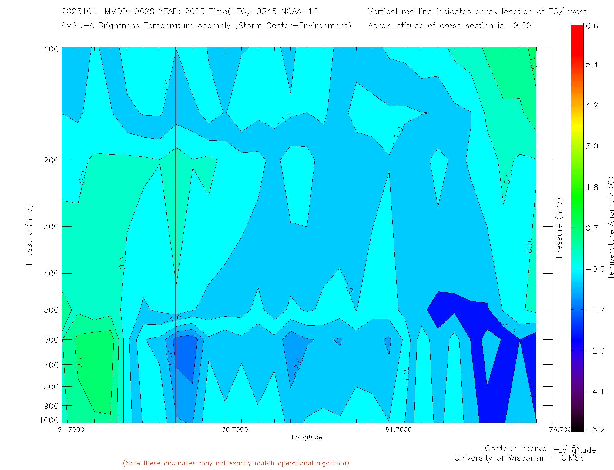
Microwave sounding analysis shows cold anomalous air temperature above the surface of the water.
Heat flow from the ocean into Idalia is directly proportional to the difference in the water temperature and the air temperature.
The hotter the water, the more heat flow or the colder the air, the more heat flow.
Idalia is efficiently pulling heat out of the water.
The vertical red line represents the CoC
https://tropic.ssec.wisc.edu/real-time/ ... _xsect.gif
3 likes

Re: ATL: IDALIA - Tropical Storm - Discussion
5am and NHC says Cat 1 tip Cuba and Cat 3 approaching landfall Big Bend…passing close to Tamp/St Pete.
2 days out
Ouch!
2 days out
Ouch!
2 likes
Re: ATL: IDALIA - Tropical Storm - Discussion
Judging by the Cuba and Cancun radars, eye may be open to the west
0 likes

Re: ATL: IDALIA - Tropical Storm - Discussion
I have a feeling upgrade to H1 will occur shortly. The northern edge is starting to fill in big time.
0 likes
Re: ATL: IDALIA - Tropical Storm - Discussion
Interesting how this may play out in the GoM as far as UL ventilation is concerned.
Franklin, ridge below Franklin, ULL over Mexico, and UL Trof in W GOM will all combine to pinch off outflow at 250mb.
There is a big kicker though.
If the vort column is unusually high; i.e. punches thru the tropopause, then all these external effects will turn around and help to strengthen Idalia.
Going to watch this effect closely.
4 likes
Re: ATL: IDALIA - Tropical Storm - Discussion
Judging from radar, looks like the new convective burst on IR, straight east of Cozumel is the CoC
20.5N 85.1W
20.5N 85.1W
0 likes
-
Clearcloudz

- Category 2
- Posts: 540
- Joined: Sun Jun 10, 2018 1:46 pm
- Location: Rosenberg TX
Re: ATL: IDALIA - Tropical Storm - Discussion
11 feet storm surge in parts of Tampa Bay.  Are officials in Tampa waiting for 11 AM advisory for evacuations cause they are cutting it close when it comes giving enough time to educate the people of what might happen.

4 likes

Re: ATL: IDALIA - Tropical Storm - Discussion
Waking up to everyone, professionals included, in Bradenton and St. Pete practically sounding the all clear alarm. Been a little disappointing to see the complete lack of concern around here
2 likes
Re: ATL: IDALIA - Tropical Storm - Discussion
d3v123 wrote:Waking up to everyone, professionals included, in Bradenton and St. Pete practically sounding the all clear alarm. Been a little disappointing to see the complete lack of concern around here
I live in Largo - Indian rocks. I've not heard that at all. We are in the cone and some areas facing up to an 11 ft. Storm surge. Prepare for up to Cat 3. Winds
1 likes
Re: ATL: IDALIA - Tropical Storm - Discussion
d3v123 wrote:Waking up to everyone, professionals included, in Bradenton and St. Pete practically sounding the all clear alarm. Been a little disappointing to see the complete lack of concern around here
I live in Largo - Indian rocks. I've not heard that at all. We are in the cone and some areas facing up to an 11 ft. Storm surge. Prepare for up to Cat 3. Winds and expect minimum Cat. 1 winds.
2 likes
Re: ATL: IDALIA - Tropical Storm - Discussion
caneman wrote:d3v123 wrote:Waking up to everyone, professionals included, in Bradenton and St. Pete practically sounding the all clear alarm. Been a little disappointing to see the complete lack of concern around here
I live in Largo - Indian rocks. I've not heard that at all. We are in the cone and some areas facing up to an 11 ft. Storm surge. Prepare for up to Cat 3. Winds
Well I’m glad to hear that! Maybe it’s the attitude here in Manatee even though we’re not that far at all.
1 likes
Who is online
Users browsing this forum: No registered users and 193 guests