
The current record for the northernmost Category 5 Atlantic hurricane is held by Lorenzo at 24.3N. Franklin is already at 27.2N, and has a real chance at shattering that record.
Crazy what record warm SSTs can do.
ATL: FRANKLIN - Post-Tropical - Discussion
Moderator: S2k Moderators
Re: ATL: FRANKLIN - Hurricane - Discussion Update= Up to 130 mph
0 likes
TC naming lists: retirements and intensity
Most aggressive Advisory #1's in North Atlantic (cr. kevin for starting the list)
Most aggressive Advisory #1's in North Atlantic (cr. kevin for starting the list)
-
MarioProtVI
- Category 5

- Posts: 1039
- Age: 24
- Joined: Sun Sep 29, 2019 7:33 pm
- Location: New Jersey
Re: ATL: FRANKLIN - Hurricane - Latest Update = 145 mph
WTF? Was not expecting to wake up to Franklin like THIS. If it becomes a C5…It wasn’t really supposed to peak until Wednesday!
0 likes
-
cycloneye

- Admin

- Posts: 149730
- Age: 69
- Joined: Thu Oct 10, 2002 10:54 am
- Location: San Juan, Puerto Rico
Re: ATL: FRANKLIN - Hurricane - Latest Update = 145 mph
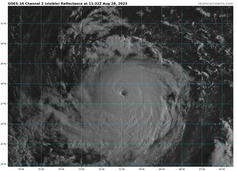
Hurricane Franklin Tropical Cyclone Update
NWS National Hurricane Center Miami FL AL082023
900 AM EDT Mon Aug 28 2023
...FRANKLIN RAPIDLY INTENSIFYING...
Air Force Reserve Hurricane Hunter aircraft data indicate that
Hurricane Franklin is rapidly intensifying. The maximum winds are
estimated to be 145 mph (230 km/h) with higher gusts. The minimum
central pressure has decreased to 937 mb. The next full advisory on
Franklin will be at 11AM EDT (1500 UTC), and the intensity forecast
at that time will be increased from the previous advisory given the
ongoing rapid intensification.
SUMMARY OF 0900 AM...1300 UTC...INFORMATION
----------------------------------------------
LOCATION...27.5N 70.9W
ABOUT 410 MI...660 KM N OF GRAND TURK ISLAND
ABOUT 485 MI...780 KM SW OF BERMUDA
MAXIMUM SUSTAINED WINDS...145 MPH...230 KM/H
PRESENT MOVEMENT...NNW OR 335 DEGREES AT 8 MPH...13 KM/H
MINIMUM CENTRAL PRESSURE...937 MB...27.67 INCHES
$$
Forecaster Kelly/Brown
0 likes
Visit the Caribbean-Central America Weather Thread where you can find at first post web cams,radars
and observations from Caribbean basin members Click Here
and observations from Caribbean basin members Click Here
-
tolakram
- Admin
- Posts: 20186
- Age: 62
- Joined: Sun Aug 27, 2006 8:23 pm
- Location: Florence, KY (name is Mark)
Re: ATL: FRANKLIN - Hurricane - Latest Update = 145 mph
0 likes
M a r k
- - - - -
Join us in chat: Storm2K Chatroom Invite. Android and IOS apps also available.
The posts in this forum are NOT official forecasts and should not be used as such. Posts are NOT endorsed by any professional institution or STORM2K.org. For official information and forecasts, please refer to NHC and NWS products.
-
Iceresistance

- Category 5
- Posts: 9608
- Age: 22
- Joined: Sat Oct 10, 2020 9:45 am
- Location: Tecumseh, OK/Norman, OK
Re: ATL: FRANKLIN - Hurricane - Latest Update = 145 mph

1 likes
Bill 2015 & Beta 2020
Winter 2020-2021
All observations are in Tecumseh, OK unless otherwise noted.
Winter posts are focused mainly for Oklahoma & Texas.
Take any of my forecasts with a grain of salt, refer to the NWS, SPC, and NHC for official information
Never say Never with weather! Because ANYTHING is possible!
Winter 2020-2021
All observations are in Tecumseh, OK unless otherwise noted.
Winter posts are focused mainly for Oklahoma & Texas.
Take any of my forecasts with a grain of salt, refer to the NWS, SPC, and NHC for official information
Never say Never with weather! Because ANYTHING is possible!
-
Iceresistance
- Category 5
- Posts: 9608
- Age: 22
- Joined: Sat Oct 10, 2020 9:45 am
- Location: Tecumseh, OK/Norman, OK
Re: ATL: FRANKLIN - Hurricane - Latest Update = 145 mph
ADT is now at a 6
UW - CIMSS
ADVANCED DVORAK TECHNIQUE
ADT-Version 9.1
Tropical Cyclone Intensity Algorithm
----- Current Analysis -----
Date : 28 AUG 2023 Time : 124020 UTC
Lat : 27:28:47 N Lon : 70:57:35 W
CI# /Pressure/ Vmax
6.0 / 941.8mb/115.0kt
Final T# Adj T# Raw T#
6.0 6.0 6.0
Estimated radius of max. wind based on IR : 16 km
Center Temp : +15.7C Cloud Region Temp : -64.0C
Scene Type : EYE
0 likes
Bill 2015 & Beta 2020
Winter 2020-2021
All observations are in Tecumseh, OK unless otherwise noted.
Winter posts are focused mainly for Oklahoma & Texas.
Take any of my forecasts with a grain of salt, refer to the NWS, SPC, and NHC for official information
Never say Never with weather! Because ANYTHING is possible!
Winter 2020-2021
All observations are in Tecumseh, OK unless otherwise noted.
Winter posts are focused mainly for Oklahoma & Texas.
Take any of my forecasts with a grain of salt, refer to the NWS, SPC, and NHC for official information
Never say Never with weather! Because ANYTHING is possible!

Re: ATL: FRANKLIN - Hurricane - Latest Update = 145 mph
Eye drop of 936/9 supports 935 mbar, down from 943/9 (942 mbar) just an hour and 35 minutes earlier. That’s a deepening rate of 4.4 mb/hr. If this keeps up for just a few more hours, we would see a Cat 5. A shame that we’ll have to wait until tonight for recon, but this flight has been helpful in showing that Franklin is running 10-15+ kt ahead of satellite estimates; ADT is only around 110-115 kt.
0 likes
Irene '11 Sandy '12 Hermine '16 5/15/2018 Derecho Fay '20 Isaias '20 Elsa '21 Henri '21 Ida '21
I am only a meteorology enthusiast who knows a decent amount about tropical cyclones. Look to the professional mets, the NHC, or your local weather office for the best information.
I am only a meteorology enthusiast who knows a decent amount about tropical cyclones. Look to the professional mets, the NHC, or your local weather office for the best information.
-
tolakram
- Admin
- Posts: 20186
- Age: 62
- Joined: Sun Aug 27, 2006 8:23 pm
- Location: Florence, KY (name is Mark)
Re: ATL: FRANKLIN - Hurricane - Latest Update = 145 mph

9 likes
M a r k
- - - - -
Join us in chat: Storm2K Chatroom Invite. Android and IOS apps also available.
The posts in this forum are NOT official forecasts and should not be used as such. Posts are NOT endorsed by any professional institution or STORM2K.org. For official information and forecasts, please refer to NHC and NWS products.
- - - - -
Join us in chat: Storm2K Chatroom Invite. Android and IOS apps also available.
The posts in this forum are NOT official forecasts and should not be used as such. Posts are NOT endorsed by any professional institution or STORM2K.org. For official information and forecasts, please refer to NHC and NWS products.
-
Iceresistance
- Category 5
- Posts: 9608
- Age: 22
- Joined: Sat Oct 10, 2020 9:45 am
- Location: Tecumseh, OK/Norman, OK
Re: ATL: FRANKLIN - Hurricane - Latest Update = 145 mph

3 likes
Bill 2015 & Beta 2020
Winter 2020-2021
All observations are in Tecumseh, OK unless otherwise noted.
Winter posts are focused mainly for Oklahoma & Texas.
Take any of my forecasts with a grain of salt, refer to the NWS, SPC, and NHC for official information
Never say Never with weather! Because ANYTHING is possible!
Winter 2020-2021
All observations are in Tecumseh, OK unless otherwise noted.
Winter posts are focused mainly for Oklahoma & Texas.
Take any of my forecasts with a grain of salt, refer to the NWS, SPC, and NHC for official information
Never say Never with weather! Because ANYTHING is possible!
-
captainbarbossa19

- Professional-Met

- Posts: 1094
- Age: 27
- Joined: Wed Aug 21, 2019 11:09 pm
- Location: Beaumont, TX
Re: ATL: FRANKLIN - Hurricane - Latest Update = 145 mph
Reminds me of Jose and Irma except Idalia is not very strong yet.
0 likes
-
Sciencerocks
- Category 5
- Posts: 10193
- Age: 40
- Joined: Thu Jul 06, 2017 1:51 am

-
Category5Kaiju

- Category 5
- Posts: 4347
- Joined: Thu Dec 24, 2020 12:45 pm
- Location: Seattle during the summer, Phoenix during the winter
Re: ATL: FRANKLIN - Hurricane - Latest Update = 145 mph
captainbarbossa19 wrote:
Reminds me of Jose and Irma except Idalia is not very strong yet.
Strange coincidence, but last year we had an open ocean Cat 4 that was the F storm, and an I storm threatening the West Coast of Florida too. Now look at what’s happening.
3 likes
Unless explicitly stated, all information in my posts is based on my own opinions and observations. Tropical storms and hurricanes can be extremely dangerous. Refer to an accredited weather research agency or meteorologist if you need to make serious decisions regarding an approaching storm.
-
REDHurricane

- Category 1

- Posts: 438
- Age: 28
- Joined: Sun Jul 03, 2022 2:36 pm
- Location: Northeast Pacific Ocean
-
TheAustinMan

- Category 5
- Posts: 1060
- Joined: Mon Jul 08, 2013 4:26 pm
- Location: Central TX / United States
Re: ATL: FRANKLIN - Hurricane - Latest Update = 145 mph
Franklin is well positioned for GOES-18 to get a great side shot of the storm this morning. A fantastic satellite appearance --
Hurricane Franklin as seen from the perspective of the GOES-18/GOES-WEST satellite. Source: GOES MSFC

Hurricane Franklin as seen from the perspective of the GOES-18/GOES-WEST satellite. Source: GOES MSFC
9 likes
Treat my opinions with a grain of salt. For official information see your local weather service.
“It's tough to make predictions, especially about the future.”
“It's tough to make predictions, especially about the future.”
-
cycloneye
- Admin
- Posts: 149730
- Age: 69
- Joined: Thu Oct 10, 2002 10:54 am
- Location: San Juan, Puerto Rico
Re: ATL: FRANKLIN - Hurricane - Latest Update = 145 mph
TheAustinMan wrote:Franklin is well positioned for GOES-18 to get a great side shot of the storm this morning. A fantastic satellite appearance --
Hurricane Franklin as seen from the perspective of the GOES-18/GOES-WEST satellite. Source: GOES MSFC
https://i.imgur.com/XdVCHAS.png
A superb view.
2 likes
Visit the Caribbean-Central America Weather Thread where you can find at first post web cams,radars
and observations from Caribbean basin members Click Here
and observations from Caribbean basin members Click Here
-
Bocadude85

- Category 5
- Posts: 2991
- Age: 39
- Joined: Mon Apr 18, 2005 2:20 pm
- Location: Honolulu,Hi
Re: ATL: FRANKLIN - Hurricane - Discussion Update= Up to 130 mph
Teban54 wrote:The current record for the northernmost Category 5 Atlantic hurricane is held by Lorenzo at 24.3N. Franklin is already at 27.2N, and has a real chance at shattering that record.
Crazy what record warm SSTs can do.
Andrew and Dorian were both north of 25N as Cat 5’s
3 likes
Re: ATL: FRANKLIN - Hurricane - Discussion Update= Up to 130 mph
Bocadude85 wrote:Teban54 wrote:The current record for the northernmost Category 5 Atlantic hurricane is held by Lorenzo at 24.3N. Franklin is already at 27.2N, and has a real chance at shattering that record.
Crazy what record warm SSTs can do.
Andrew and Dorian were both north of 25N as Cat 5’s
Oops sorry, got my facts mixed up. Lorenzo was the eaternmost.
0 likes
TC naming lists: retirements and intensity
Most aggressive Advisory #1's in North Atlantic (cr. kevin for starting the list)
Most aggressive Advisory #1's in North Atlantic (cr. kevin for starting the list)
Re: ATL: FRANKLIN - Hurricane - Discussion
Michael was a cat 5 at 30.0N. But the Gulf is just different from open sea.
0 likes
-
HurricaneEnzo

- Category 2

- Posts: 744
- Joined: Wed Mar 14, 2018 12:18 pm
- Location: Newport, NC (Hurricane Alley)
Re: ATL: FRANKLIN - Hurricane - Discussion Update= Up to 130 mph
Michael was further North wasn't it? Or do you just mean the open Atlantic not including GoM or Carib.
Teban54 wrote:The current record for the northernmost Category 5 Atlantic hurricane is held by Lorenzo at 24.3N. Franklin is already at 27.2N, and has a real chance at shattering that record.
Crazy what record warm SSTs can do.
0 likes
Bertha 96' - Fran 96' - Bonnie 98' - Dennis 99' - Floyd 99' - Isabel 03' - Alex 04' - Ophelia 05' - Irene 11' - Arthur 14' - Matthew 16' - Florence 18' - Dorian 19' - Isaias 20' (countless other tropical storms and Hurricane swipes)
I am not a Professional Met just an enthusiast. Get your weather forecasts from the Pros!
I am not a Professional Met just an enthusiast. Get your weather forecasts from the Pros!
Who is online
Users browsing this forum: No registered users and 33 guests