ATL: IDALIA - Models
Moderator: S2k Moderators

Re: ATL: IDALIA - Models
If the hurricane models are right, we should see rapid organization and eyewall development starting tomorrow morning as Idalia passes by Cuba and shear drops. The HWRF and HAFS-A/B show this lopsided look like a pressure in the upper 980s/lower 990s through the rest of the day today.
0 likes
Irene '11 Sandy '12 Hermine '16 5/15/2018 Derecho Fay '20 Isaias '20 Elsa '21 Henri '21 Ida '21
I am only a meteorology enthusiast who knows a decent amount about tropical cyclones. Look to the professional mets, the NHC, or your local weather office for the best information.
I am only a meteorology enthusiast who knows a decent amount about tropical cyclones. Look to the professional mets, the NHC, or your local weather office for the best information.

Re: ATL: IDALIA - Models
Steve wrote:Intensity models have soared into Cat 2 territory from TS/1 they had been showing.
https://www.tropicaltidbits.com/stormin ... latest.png
Pretty unique setup for a NE Gulf hit with an intensifying til landfall hit which NHC is currently forecasting to be a major at landfall. You may not see this again (if their forecast verifies) the remainder of your life.
We don't want to see it at all lol.
2 likes
Robbielyn McCrary
I know just about enough to sound like I know what I'm talking about sometimes. But for your safety please follow the nhc for truly professional forecasting.
I know just about enough to sound like I know what I'm talking about sometimes. But for your safety please follow the nhc for truly professional forecasting.
-
tolakram
- Admin

- Posts: 20179
- Age: 62
- Joined: Sun Aug 27, 2006 8:23 pm
- Location: Florence, KY (name is Mark)
Re: ATL: IDALIA - Models
It's a ways out still but if this verifies northern FL, coastal GA, SC, NC need to be prepared. Lots of onshore winds and some surge to deal with.

1 likes
M a r k
- - - - -
Join us in chat: Storm2K Chatroom Invite. Android and IOS apps also available.
The posts in this forum are NOT official forecasts and should not be used as such. Posts are NOT endorsed by any professional institution or STORM2K.org. For official information and forecasts, please refer to NHC and NWS products.
Re: ATL: IDALIA - Models
 What's so "crazy" by this consensus... if it's wrong by 30-50 miles to the east/south... this entire storm narrative changes
0 likes
-
MJGarrison
- Tropical Storm

- Posts: 146
- Joined: Wed Aug 30, 2017 7:26 pm
Re: ATL: IDALIA - Models
LandoWill wrote:
How do these early models work again? They just move the starting point and keep the same track from the earlier run, right?
Sent from my iPad using Tapatalk
1 likes

Re: ATL: IDALIA - Models
robbielyn wrote:Steve wrote:Intensity models have soared into Cat 2 territory from TS/1 they had been showing.
https://www.tropicaltidbits.com/stormin ... latest.png
Pretty unique setup for a NE Gulf hit with an intensifying til landfall hit which NHC is currently forecasting to be a major at landfall. You may not see this again (if their forecast verifies) the remainder of your life.
We don't want to see it at all lol.
Haha. And here we are with warm ass water up there in the Bend and strange pressure pattern that could allow for a once in a forever setup.
0 likes
-
FLLurker32
- Tropical Storm
- Posts: 245
- Joined: Mon Aug 29, 2016 10:31 am
Re: ATL: IDALIA - Models
LandoWill wrote:https://www.tropicaltidbits.com/storminfo/10L_tracks_12z.png What's so "crazy" by this consensus... if it's wrong by 30-50 miles to the east/south... this entire storm narrative changes
All it would take is a wobble along the way to change everything for this one.
1 likes
Heather

Re: ATL: IDALIA - Models
Important benchmark tomorrow. If the storm is centered at 25N-85W then it's in the middle of the model consensus. East of there, not good for Tampa northward. West of there, more of panhandle concern.
6 likes


Re: ATL: IDALIA - Models
Latest 11am NHC track centered on 06z Euro landfall near Steinhatchee (border of Dixie and Taylor Counties). Slight west adjustment from 5 am track.
0 likes
-
tolakram
- Admin
- Posts: 20179
- Age: 62
- Joined: Sun Aug 27, 2006 8:23 pm
- Location: Florence, KY (name is Mark)
Re: ATL: IDALIA - Models
Forecast track for comparisons

0 likes
M a r k
- - - - -
Join us in chat: Storm2K Chatroom Invite. Android and IOS apps also available.
The posts in this forum are NOT official forecasts and should not be used as such. Posts are NOT endorsed by any professional institution or STORM2K.org. For official information and forecasts, please refer to NHC and NWS products.
- - - - -
Join us in chat: Storm2K Chatroom Invite. Android and IOS apps also available.
The posts in this forum are NOT official forecasts and should not be used as such. Posts are NOT endorsed by any professional institution or STORM2K.org. For official information and forecasts, please refer to NHC and NWS products.

-
eastcoastFL

- Category 5

- Posts: 3996
- Age: 44
- Joined: Thu Apr 12, 2007 12:29 pm
- Location: Palm City, FL
Re: ATL: IDALIA - Models

0 likes
Personal Forecast Disclaimer:
The posts in this forum are NOT official forecast and should not be used as such. They are just the opinion of the poster and may or may not be backed by sound meteorological data. They are NOT endorsed by any professional institution or storm2k.org. For official information, please refer to the NHC and NWS products.
The posts in this forum are NOT official forecast and should not be used as such. They are just the opinion of the poster and may or may not be backed by sound meteorological data. They are NOT endorsed by any professional institution or storm2k.org. For official information, please refer to the NHC and NWS products.


Re: ATL: IDALIA - Models
eastcoastFL wrote:https://www.tropicaltidbits.com/storminfo/10L_intensity_latest.png
I'm hoping the downward trend in peak intensity (which shows the aggressiveness of the current NHC forecast) will play out, but that's probably wishful thinking, especially after seeing Franklin way overperforming model expectations today.
0 likes
TC naming lists: retirements and intensity
Most aggressive Advisory #1's in North Atlantic (cr. kevin for starting the list)
Most aggressive Advisory #1's in North Atlantic (cr. kevin for starting the list)
-
Blown Away

- S2K Supporter

- Posts: 10253
- Joined: Wed May 26, 2004 6:17 am
Re: ATL: IDALIA - Models
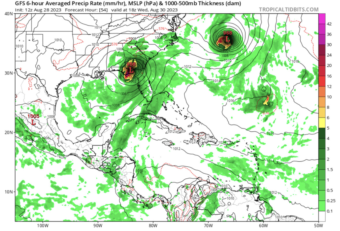
06z GFS… Consistently into Big Bend area. Franklin & Idalia at same pressure…
0 likes
Hurricane Eye Experience: David 79, Irene 99, Frances 04, Jeanne 04, Wilma 05… Hurricane Brush Experience: Andrew 92, Erin 95, Floyd 99, Matthew 16, Irma 17, Ian 22, Nicole 22…

Who is online
Users browsing this forum: No registered users and 64 guests