18z GFS…
Moderator: S2k Moderators


Blown Away wrote:[url]https://i.postimg.cc/76jW2vSj/gfs-mslp-pcpn-seus-fh24-216.gif [/url]
18z GFS…

SconnieCane wrote:Is that Idalia coming back for FL round 2?


USTropics wrote:the 12z ECMWF developed this on its operational run:
https://i.imgur.com/4uWeA2o.png
mantis83 wrote:huge weakness in atlantic will easily scoop this up and out.....


USTropics wrote:mantis83 wrote:huge weakness in atlantic will easily scoop this up and out.....
There are quite a few ensemble members that show building high pressure behind this system with a weakening trough over the western North Atlantic, some members have a distinct bend back to the west showing this:
https://i.imgur.com/8oHdN2Z.png
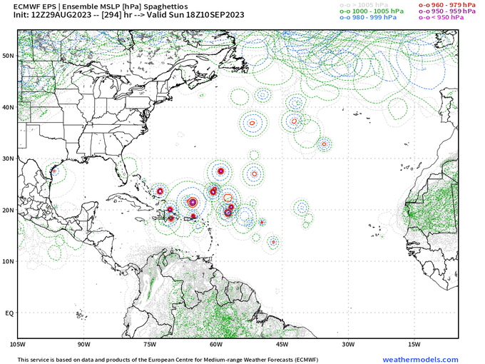
With the usual caveats this is a long range forecast (240 hours), but the EPS doesnt show a strong signal for a trough:
https://i.imgur.com/TpWj1d3.png
Hopefully it stays away, no more florida hurricanes this season.Ianswfl wrote:
If certain members of that run panned out that storm would be far more destructive for FL assuming there is a high in place.
jlauderdal wrote:Hopefully it stays away, no more florida hurricanes this season.Ianswfl wrote:
If certain members of that run panned out that storm would be far more destructive for FL assuming there is a high in place.
You are going to wait until 24hrs to evac people? Too many people from non evac zones leave.cane5 wrote:This will be the second year in a row all we heard was Tampa Tampa Tampa and the models were off by over 100 miles. The weather channel just needs to slow down the hype until the storm is 24 hours before landfall.
Does not mean we don’t need a cone of concern because it generally is mildly accurate 3 days out but it’s almost getting silly and a waste of millions to relocate people 3 days in advance.
cane5 wrote:This will be the second year in a row all we heard was Tampa Tampa Tampa and the models were off by over 100 miles. The weather channel just needs to slow down the hype until the storm is 24 hours before landfall.
Does not mean we don’t need a cone of concern because it generally is mildly accurate 3 days out but it’s almost getting silly and a waste of millions to relocate people 3 days in advance.
Users browsing this forum: AnnularCane, cycloneye, USTropics and 210 guests