Mesoscale Discussion 2060
NWS Storm Prediction Center Norman OK
0644 PM CDT Tue Aug 29 2023
Areas affected...Western Florida Peninsula
Concerning...Severe potential...Tornado Watch likely
Valid 292344Z - 300215Z
Probability of Watch Issuance...80 percent
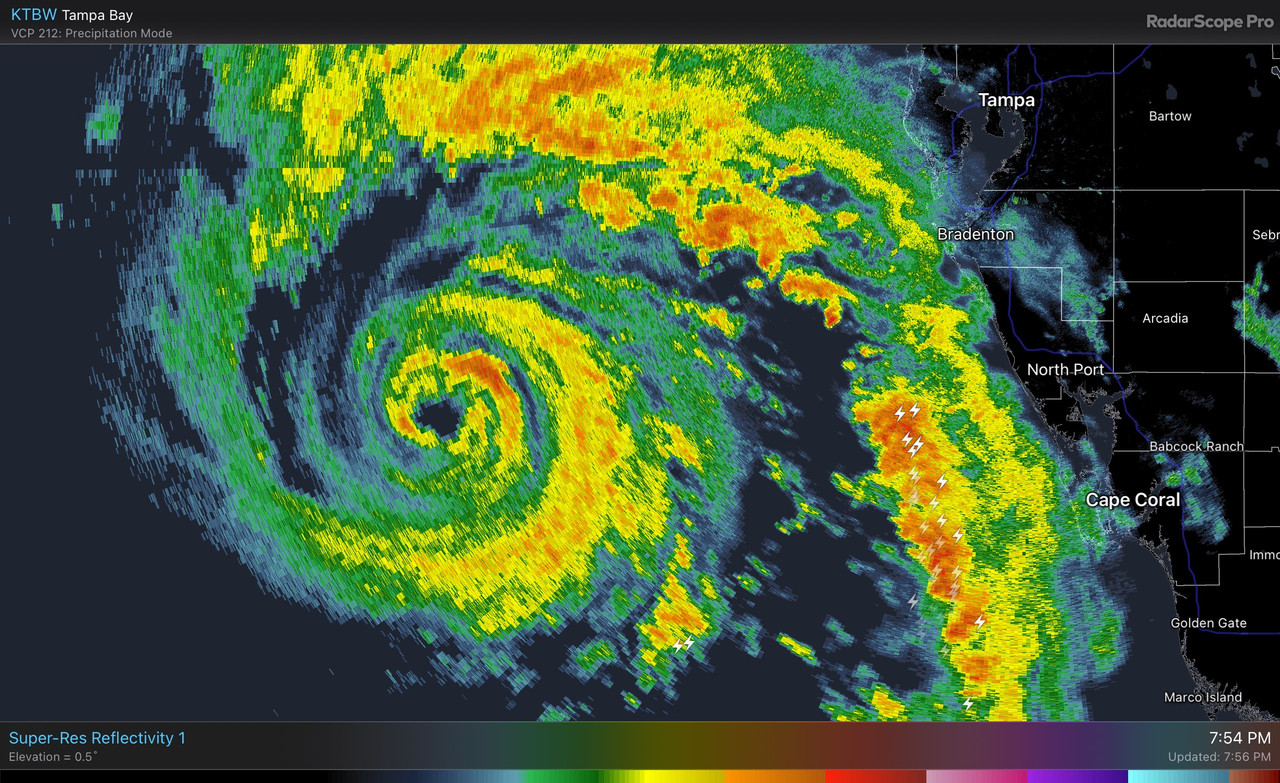
SUMMARY...A tornado threat is expected to develop across the western
Florida Peninsula this evening. Once the tornado threat begins to
develop, a tornado watch will be needed, likely later this evening.
DISCUSSION...Hurricane Idalia will continue to move
north-northeastward across the eastern Gulf of Mexico this evening.
The outer bands of Hurricane Idalia will begin to impact the western
coast of Florida in a few hours. As these bands move into the
coastal areas later this evening, strong low-level shear will be
maintained as a low-level speed max brushes the coast. The latest
WSR-88D VWP at Tampa Bay has 0-3 km storm-relative helicity near 500
m2/s2, and RAP forecast soundings increase low-level shear along the
western coast from south to north over the next few hours. This
suggests that discrete cells embedded in the outerbands of Idalia
may develop tornado potential. The threat is forecast to gradually
transition northward to the area southwest of Gainsville, Florida by
late evening.
..Broyles/Hart.. 08/29/2023
...Please see www.spc.noaa.gov for graphic product...
ATL: IDALIA - Post-Tropical - Discussion
Moderator: S2k Moderators
-
HurricaneBelle

- S2K Supporter

- Posts: 1209
- Joined: Sun Aug 27, 2006 6:12 pm
- Location: Clearwater, FL
Re: ATL: IDALIA - Hurricane - Discussion
SPC expecting a tornado threat along the west coast of FL:
2 likes

Re: ATL: IDALIA - Hurricane - Discussion
aspen wrote:This is reminding me of Michael in that it took forever to have a closed eyewall. Even like 12-18 hours before landfall, recon was still finding an open eyewall, and it wouldn’t close off until later the night before landfall IIRC.
Michael only had a proper eye for the last 6 hours before landfall, if that. Took a while to pop out. Once it did, the pressure plummeted at an exceptional rate.
1 likes
Very useful information on the Dvorak Technique --
https://severe.worldweather.wmo.int/TCF ... kBeven.pdf
https://severe.worldweather.wmo.int/TCF ... kBeven.pdf
-
tolakram
- Admin

- Posts: 20174
- Age: 62
- Joined: Sun Aug 27, 2006 8:23 pm
- Location: Florence, KY (name is Mark)
Re: ATL: IDALIA - Hurricane - Discussion
nlosrgr8 wrote:If there is a silver lining…I believe the area within the cone is sparsely populated swampy areas. I am I right?
Not urban but some areas look very similar to Mexico Beach. Depends on exactly where it comes ashore.

1 likes
M a r k
- - - - -
Join us in chat: Storm2K Chatroom Invite. Android and IOS apps also available.
The posts in this forum are NOT official forecasts and should not be used as such. Posts are NOT endorsed by any professional institution or STORM2K.org. For official information and forecasts, please refer to NHC and NWS products.
-
Sciencerocks
- Category 5

- Posts: 10181
- Age: 40
- Joined: Thu Jul 06, 2017 1:51 am

-
Hypercane_Kyle

- Category 5
- Posts: 3465
- Joined: Sat Mar 07, 2015 7:58 pm
- Location: Cape Canaveral, FL
Re: ATL: IDALIA - Hurricane - Discussion
tolakram wrote:nlosrgr8 wrote:If there is a silver lining…I believe the area within the cone is sparsely populated swampy areas. I am I right?
Not urban but some areas look very similar to Mexico Beach. Depends on exactly where it comes ashore.
https://i.imgur.com/CmPya39.png
FWIW, I go up here to do some astrophotography from time to time... literally some of the darkest skies in the entire state as there's no light pollution. Make of that what you will.
7 likes
My posts are my own personal opinion, defer to the National Hurricane Center (NHC) and other NOAA products for decision making during hurricane season.

Re: ATL: IDALIA - Hurricane - Discussion
nlosrgr8 wrote:If there is a silver lining…I believe the area within the cone is sparsely populated swampy areas. I am I right?
yep, its like the lowest populated area
2 likes

Re: ATL: IDALIA - Hurricane - Discussion
CrazyC83 wrote:322
URNT15 KNHC 292343
AF304 1110A IDALIA HDOB 32 20230829
233430 2640N 08430W 6959 02940 //// +106 //// 237092 097 074 022 01
233500 2641N 08431W 6968 02915 //// +109 //// 234079 088 084 015 01
233530 2642N 08433W 6970 02895 //// +111 //// 234057 075 084 015 01
233600 2643N 08434W 6976 02875 9692 +127 //// 229047 048 065 006 01
233630 2644N 08435W 6958 02888 9683 +137 //// 230040 048 047 004 01
233700 2645N 08437W 6966 02865 9660 +147 +132 224035 038 040 002 00
233730 2647N 08438W 6963 02859 9639 +158 +125 223022 030 036 002 00
233800 2648N 08439W 6969 02847 9634 +158 +128 260011 018 028 001 00
233830 2650N 08440W 6975 02833 9624 +163 +134 334005 010 022 000 03
233900 2651N 08440W 6951 02864 9633 +155 +134 118011 018 022 000 00
233930 2653N 08439W 6966 02855 9647 +152 +124 140027 029 024 000 03
234000 2652N 08437W 6968 02851 9643 +153 +123 151027 029 /// /// 03
234030 2651N 08439W 6964 02843 9627 +155 +123 146011 025 019 001 00
234100 2650N 08441W 6970 02836 9632 +150 +137 337016 023 023 002 00
234130 2648N 08442W 6957 02860 9653 +138 //// 324035 048 028 002 01
234200 2646N 08442W 6969 02868 9670 +142 +141 303062 063 /// /// 03
234230 2645N 08440W 6967 02868 9673 +140 //// 283055 064 /// /// 05
234300 2646N 08438W 6958 02864 9659 +134 //// 259044 051 /// /// 05
234330 2648N 08437W 6970 02837 9637 +145 +141 228026 038 029 001 03
234400 2649N 08438W 6968 02836 9625 +156 +129 230012 021 028 002 00
$$
;
97 kt FL, 84 kt SFMR. Pressure 962 mb.
The NOAA eye drop that supported 965 mb was at 23:01z, and the 962.5 mb extrap was at 23:44z. Taking the extrap verbatim, this suggests a deepening rate of 3.4 mb/hr during this time, and 2.8 mb/hr since the first AF eye drop that supported 972 mb.
0 likes
TC naming lists: retirements and intensity
Most aggressive Advisory #1's in North Atlantic (cr. kevin for starting the list)
Most aggressive Advisory #1's in North Atlantic (cr. kevin for starting the list)
Re: ATL: IDALIA - Hurricane - Discussion
Hypercane_Kyle wrote:tolakram wrote:nlosrgr8 wrote:If there is a silver lining…I believe the area within the cone is sparsely populated swampy areas. I am I right?
Not urban but some areas look very similar to Mexico Beach. Depends on exactly where it comes ashore.
https://i.imgur.com/CmPya39.png
FWIW, I go up here to do some astrophotography from time to time... literally some of the darkest skies in the entire state as there's no light pollution. Make of that what you will.
Better than that park in Orlando area? i forgot what it's called.
0 likes

Re: ATL: IDALIA - Hurricane - Discussion
Mesoscale Discussion 2060
NWS Storm Prediction Center Norman OK
0644 PM CDT Tue Aug 29 2023
https://www.spc.noaa.gov/products/md/md2060.html
Areas affected...Western Florida Peninsula
Concerning...Severe potential...Tornado Watch likely
Valid 292344Z - 300215Z
Probability of Watch Issuance...80 percent
SUMMARY...A tornado threat is expected to develop across the western
Florida Peninsula this evening. Once the tornado threat begins to
develop, a tornado watch will be needed, likely later this evening.
DISCUSSION...Hurricane Idalia will continue to move
north-northeastward across the eastern Gulf of Mexico this evening.
The outer bands of Hurricane Idalia will begin to impact the western
coast of Florida in a few hours. As these bands move into the
coastal areas later this evening, strong low-level shear will be
maintained as a low-level speed max brushes the coast. The latest
WSR-88D VWP at Tampa Bay has 0-3 km storm-relative helicity near 500
m2/s2, and RAP forecast soundings increase low-level shear along the
western coast from south to north over the next few hours. This
suggests that discrete cells embedded in the outerbands of Idalia
may develop tornado potential. The threat is forecast to gradually
transition northward to the area southwest of Gainsville, Florida by
late evening.
..Broyles/Hart.. 08/29/2023
1 likes
-
eastcoastFL

- Category 5
- Posts: 3996
- Age: 44
- Joined: Thu Apr 12, 2007 12:29 pm
- Location: Palm City, FL
Re: ATL: IDALIA - Hurricane - Discussion
PavelGaborik10 wrote:Teban54 wrote:Highteeld wrote:Probably down to 967 mb. 3mb/hr roughly
Looks like all those comments about Idalia not strengthening much aged like milk.
I mean, she's certainly strengthening but this is far from the worst case scenario. Eye is still quite ragged and the winds haven't exactly exploded, landfall isn't that far away anymore.
RI has to start somewhere it doesn't fast forward so I'd say 3mb drop in an hour is a good start.
0 likes
Personal Forecast Disclaimer:
The posts in this forum are NOT official forecast and should not be used as such. They are just the opinion of the poster and may or may not be backed by sound meteorological data. They are NOT endorsed by any professional institution or storm2k.org. For official information, please refer to the NHC and NWS products.
The posts in this forum are NOT official forecast and should not be used as such. They are just the opinion of the poster and may or may not be backed by sound meteorological data. They are NOT endorsed by any professional institution or storm2k.org. For official information, please refer to the NHC and NWS products.
-
stormhunter7

- Category 2

- Posts: 763
- Joined: Mon May 26, 2008 3:13 pm
- Location: Panama City Beach, Florida
- Contact:
Re: ATL: IDALIA - Hurricane - Discussion
Just took a trip down to Port St. Joe, in Gulf County from Panama City. Can confirm folks are heading westbound and loaded down! Saw RV's, campers, boats, and lots of loaded down vehicles heading west on HWY 98 this afternoon.
4 likes
The following post is NOT an official forecast and should not be used as such. It is just the opinion of the poster and may or may not be backed by sound meteorological data. It is NOT endorsed by any professional institution including storm2k.org For Official Information please refer to the NHC and NWS products. http://www.nhc.noaa.gov

-
SFLcane

- S2K Supporter
- Posts: 10281
- Age: 48
- Joined: Sat Jun 05, 2010 1:44 pm
- Location: Lake Worth Florida
Re: ATL: IDALIA - Hurricane - Discussion
Eyeball now closed…should go to town now.
Unfortunately
Unfortunately
8 likes
-
PavelGaborik10
- Category 1

- Posts: 472
- Joined: Tue Sep 04, 2018 3:23 pm
Re: ATL: IDALIA - Hurricane - Discussion
eastcoastFL wrote:PavelGaborik10 wrote:Teban54 wrote:Looks like all those comments about Idalia not strengthening much aged like milk.
I mean, she's certainly strengthening but this is far from the worst case scenario. Eye is still quite ragged and the winds haven't exactly exploded, landfall isn't that far away anymore.
RI has to start somewhere it doesn't fast forward so I'd say 3mb drop in an hour is a good start.
Indeed, however we will have to see if it continues at such a rate over a prolonged period of time, and even then there's no guarantee the winds catch up before landfall.
We're in a 12ish hour window now.
0 likes
-
Hypercane_Kyle
- Category 5
- Posts: 3465
- Joined: Sat Mar 07, 2015 7:58 pm
- Location: Cape Canaveral, FL
Re: ATL: IDALIA - Hurricane - Discussion
LandoWill wrote:Hypercane_Kyle wrote:tolakram wrote:
Not urban but some areas look very similar to Mexico Beach. Depends on exactly where it comes ashore.
https://i.imgur.com/CmPya39.png
FWIW, I go up here to do some astrophotography from time to time... literally some of the darkest skies in the entire state as there's no light pollution. Make of that what you will.
Better than that park in Orlando area? i forgot what it's called.
By an order of magnitude. That area just north of Cedar Key is especially beautiful.
3 likes
My posts are my own personal opinion, defer to the National Hurricane Center (NHC) and other NOAA products for decision making during hurricane season.
Re: ATL: IDALIA - Hurricane - Discussion
LandoWill wrote:Hugo1989 wrote:caneman wrote:On radar sure looks like a NE movement of center. Anyone else see that?
I just saw it! it does look like it will start moving NE till landfall.
NHC has given no indication that there is any chance of anything but the western part of the big bend landfall for over 36 hours now. Tampa is clear unless it comes in the "little end" of the big bend, there are 2 big bends, the big bend itself, and then the eastern one where crystal river etc.. is. that's when you worry
I'm well aware of the geography here. I've lived here since 1976. Further, the NHC never said it would come in on the western side of the cone. Radar doesn't lie and it's been verified that I was right in an east of north motion. My concern was more eastern side of the cone which brings more wind and surge to areas closer to Tampa Bay and more heavily populated areas to include Cedar Key.
Last edited by caneman on Tue Aug 29, 2023 7:02 pm, edited 2 times in total.
2 likes
-
SunnyThoughts
- Category 5
- Posts: 2263
- Joined: Wed Jul 09, 2003 12:42 pm
- Location: Pensacola, Florida


Re: ATL: IDALIA - Hurricane - Discussion
SFLcane wrote:Eyeball now closed…should go to town now.
Unfortunately
https://i.postimg.cc/XvTk7Kmf/IMG-1364.jpg
Much better.
0 likes
Very useful information on the Dvorak Technique --
https://severe.worldweather.wmo.int/TCF ... kBeven.pdf
https://severe.worldweather.wmo.int/TCF ... kBeven.pdf
Who is online
Users browsing this forum: No registered users and 36 guests