
ATL: JOSE - Remnants - Discussion
Moderator: S2k Moderators
Re: ATL: INVEST 92L - Discussion
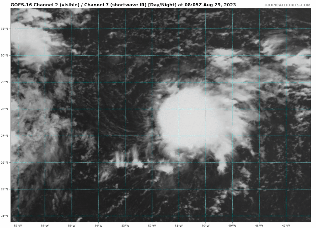
This is a tropical cyclone.
4 likes
TC naming lists: retirements and intensity
Most aggressive Advisory #1's in North Atlantic (cr. kevin for starting the list)
Most aggressive Advisory #1's in North Atlantic (cr. kevin for starting the list)
-
HurricaneEnzo

- Category 2

- Posts: 743
- Joined: Wed Mar 14, 2018 12:18 pm
- Location: Newport, NC (Hurricane Alley)
Re: ATL: INVEST 92L - Discussion
Man this invest feels like it has been out there forever and tried to spin up 3 or 4 times.  I agree though I think it has finallly done it. A TD at least.
Teban54 wrote:This is a tropical cyclone.
https://i.postimg.cc/PrMgWbzQ/goes16-vis-swir-92-L-202308290805.gif
0 likes
Bertha 96' - Fran 96' - Bonnie 98' - Dennis 99' - Floyd 99' - Isabel 03' - Alex 04' - Ophelia 05' - Irene 11' - Arthur 14' - Matthew 16' - Florence 18' - Dorian 19' - Isaias 20' (countless other tropical storms and Hurricane swipes)
I am not a Professional Met just an enthusiast. Get your weather forecasts from the Pros!
I am not a Professional Met just an enthusiast. Get your weather forecasts from the Pros!
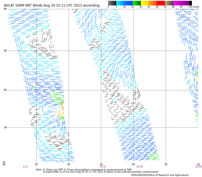
Re: ATL: INVEST 92L - Discussion
It is looking good. The latest ASCAT is still showing the circulation bee a bit stretched out. I could see the odds been bumped up a lot.
0 likes
-
Extratropical94

- Professional-Met

- Posts: 3545
- Age: 31
- Joined: Wed Oct 20, 2010 6:36 am
- Location: Hamburg, Germany
- Contact:
Re: ATL: INVEST 92L - Discussion
1. Central Subtropical Atlantic (AL92):
Shower and thunderstorm activity has increased since yesterday in
association with an area of low pressure located several hundred
miles east-southeast of Bermuda. Environmental conditions appear
conducive for some additional development of this system, and a
short-lived tropical depression could form during the next day or
two while the system drifts generally northward over the central
subtropical Atlantic. By Thursday, upper-level winds are forecast to
become unfavorable for further development of this system.
* Formation chance through 48 hours...medium...50 percent.
* Formation chance through 7 days...medium...50 percent.
0 likes
54° 11' 59'' N, 9° 9' 20'' E
Boomer Sooner!
Go Broncos! Go Cards!
Clinching counties, one at a time: https://mob-rule.com/user-gifs/USA/xtrp94.gif
- Daniel
Boomer Sooner!
Go Broncos! Go Cards!
Clinching counties, one at a time: https://mob-rule.com/user-gifs/USA/xtrp94.gif
- Daniel
-
Extratropical94
- Professional-Met
- Posts: 3545
- Age: 31
- Joined: Wed Oct 20, 2010 6:36 am
- Location: Hamburg, Germany
- Contact:
Re: ATL: INVEST 92L - Discussion
AL, 92, 2023082912, , BEST, 0, 280N, 516W, 30, 1015, LO
0 likes
54° 11' 59'' N, 9° 9' 20'' E
Boomer Sooner!
Go Broncos! Go Cards!
Clinching counties, one at a time: https://mob-rule.com/user-gifs/USA/xtrp94.gif
- Daniel
Boomer Sooner!
Go Broncos! Go Cards!
Clinching counties, one at a time: https://mob-rule.com/user-gifs/USA/xtrp94.gif
- Daniel
-
Extratropical94
- Professional-Met
- Posts: 3545
- Age: 31
- Joined: Wed Oct 20, 2010 6:36 am
- Location: Hamburg, Germany
- Contact:
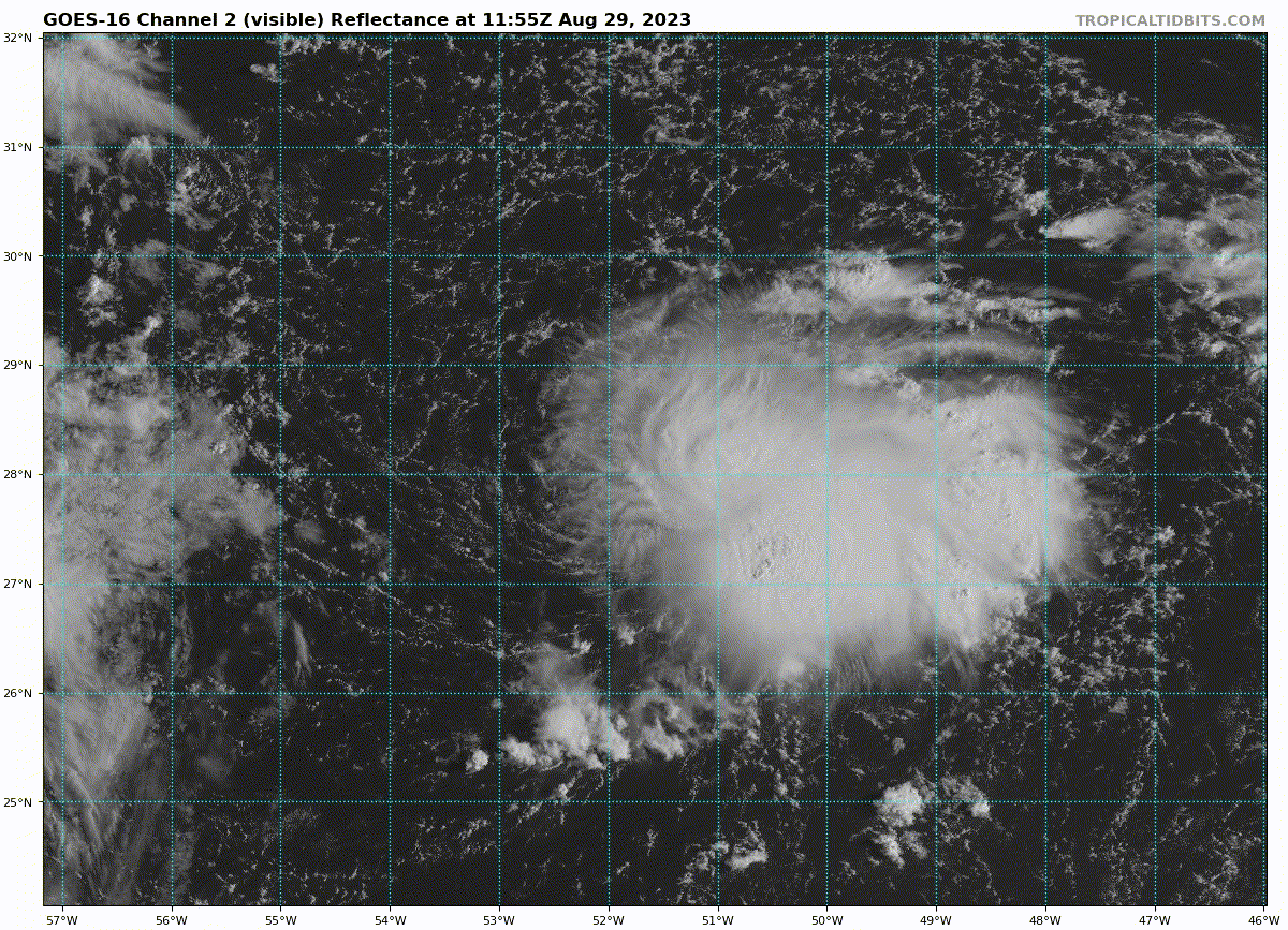
Re: ATL: INVEST 92L - Discussion
STWO
Central Subtropical Atlantic (AL92):
Updated: Recent satellite-derived wind data indicate an area of low
pressure located several hundred miles east-southeast of Bermuda has
become better defined and is producing winds of 30 to 35 mph over
the eastern portion of its circulation. The associated shower and
thunderstorm activity continues to show signs of organization, and a
short-lived tropical depression is likely to form today while the
system moves slowly northward over the central subtropical Atlantic.
* Formation chance through 48 hours...high...80 percent.
* Formation chance through 7 days...high...80 percent.
1 likes
54° 11' 59'' N, 9° 9' 20'' E
Boomer Sooner!
Go Broncos! Go Cards!
Clinching counties, one at a time: https://mob-rule.com/user-gifs/USA/xtrp94.gif
- Daniel
Boomer Sooner!
Go Broncos! Go Cards!
Clinching counties, one at a time: https://mob-rule.com/user-gifs/USA/xtrp94.gif
- Daniel
Re: ATL: ELEVEN - Tropical Depression - Discussion
AL, 11, 2023082912, , BEST, 0, 280N, 516W, 30, 1015, TD, 34, NEQ, 0, 0, 0, 0, 1018, 100, 40, 0, 0, L, 0, , 0, 0, ELEVEN, S, 0, , 0, 0, 0, 0, genesis-num, 021, TRANSITIONED, alC22023 to al112023,
0 likes
-
Sciencerocks
- Category 5

- Posts: 10181
- Age: 40
- Joined: Thu Jul 06, 2017 1:51 am
Re: ATL: ELEVEN - Tropical Depression - Discussion
TD-11 doesn't look as good as earlier, looks like it is have some shear issues which is affect the convection.
0 likes
-
Extratropical94
- Professional-Met
- Posts: 3545
- Age: 31
- Joined: Wed Oct 20, 2010 6:36 am
- Location: Hamburg, Germany
- Contact:
Re: ATL: ELEVEN - Tropical Depression - Discussion
Iceresistance wrote:...NEW TROPICAL DEPRESSION FORMS OVER THE OPEN WATERS OF THE
CENTRAL ATLANTIC...
SUMMARY OF 1100 AM AST...1500 UTC...INFORMATION
-----------------------------------------------
LOCATION...27.9N 51.4W
ABOUT 855 MI...1375 KM ESE OF BERMUDA
MAXIMUM SUSTAINED WINDS...35 MPH...55 KM/H
PRESENT MOVEMENT...N OR 360 DEGREES AT 2 MPH...4 KM/H
MINIMUM CENTRAL PRESSURE...1014 MB...29.95 INCHES
Pressure is high for a TD
Yep, it sits in a region of relatively high background SLPs. The pressure of the outermost closed isobar is even 1018mb
1 likes
54° 11' 59'' N, 9° 9' 20'' E
Boomer Sooner!
Go Broncos! Go Cards!
Clinching counties, one at a time: https://mob-rule.com/user-gifs/USA/xtrp94.gif
- Daniel
Boomer Sooner!
Go Broncos! Go Cards!
Clinching counties, one at a time: https://mob-rule.com/user-gifs/USA/xtrp94.gif
- Daniel
-
Category5Kaiju

- Category 5
- Posts: 4331
- Joined: Thu Dec 24, 2020 12:45 pm
- Location: Seattle and Phoenix
Re: ATL: ELEVEN - Tropical Depression - Discussion
Those social media comments earlier this month speculating that August 2023 could be as dead as August 2022 must be having a wonderful time now
11 likes
Unless explicitly stated, all info in my posts is based on my own opinions and observations. Tropical storms and hurricanes can be extremely dangerous. Refer to an accredited weather research agency or meteorologist if you need to make serious decisions regarding an approaching storm.


Re: ATL: ELEVEN - Tropical Depression - Discussion
Category5Kaiju wrote:Those social media comments earlier this month speculating that August 2023 could be as dead as August 2022 must be having a wonderful time now
To be honest, I myself thought it was a distinct possibility despite the much warmer than normal Atlantic Basin.
1 likes
-
Sciencerocks
- Category 5
- Posts: 10181
- Age: 40
- Joined: Thu Jul 06, 2017 1:51 am

-
wxman57

- Moderator-Pro Met

- Posts: 23172
- Age: 68
- Joined: Sat Jun 21, 2003 8:06 pm
- Location: Houston, TX (southwest)
Re: ATL: ELEVEN - Tropical Depression - Discussion
No time to post past 3 days, working 3:30am-5pm. One thing to say about Eleven:

All models have it dissipating this evening.
All models have it dissipating this evening.
5 likes
-
Sciencerocks
- Category 5
- Posts: 10181
- Age: 40
- Joined: Thu Jul 06, 2017 1:51 am

-
Sciencerocks
- Category 5
- Posts: 10181
- Age: 40
- Joined: Thu Jul 06, 2017 1:51 am

-
Sciencerocks
- Category 5
- Posts: 10181
- Age: 40
- Joined: Thu Jul 06, 2017 1:51 am


Re: ATL: ELEVEN - Tropical Depression - Discussion
Not bad at all for a system the models predicted should be dead for several days now… definitely a persistent system that has defied expectations during its life (I can’t think of any other 0/0 systems that developed within 48 hours).
In fact, I’d argue it looks nicer than several tropical storms we had this season. Definitely taking advantage of the short window it has to potentially earn a name. Hopefully we get ASCAT, but with ASCAT’s track record it will miss again and we probably won’t know how strong it is at the moment.

In fact, I’d argue it looks nicer than several tropical storms we had this season. Definitely taking advantage of the short window it has to potentially earn a name. Hopefully we get ASCAT, but with ASCAT’s track record it will miss again and we probably won’t know how strong it is at the moment.
0 likes
-
wxman57
- Moderator-Pro Met
- Posts: 23172
- Age: 68
- Joined: Sat Jun 21, 2003 8:06 pm
- Location: Houston, TX (southwest)
Re: ATL: ELEVEN - Tropical Depression - Discussion
zhukm29 wrote:Not bad at all for a system the models predicted should be dead for several days now… definitely a persistent system that has defied expectations during its life (I can’t think of any other 0/0 systems that developed within 48 hours).
In fact, I’d argue it looks nicer than several tropical storms we had this season. Definitely taking advantage of the short window it has to potentially earn a name. Hopefully we get ASCAT, but with ASCAT’s track record it will miss again and we probably won’t know how strong it is at the moment.
https://i.ibb.co/HCR30zJ/goes16-ir-11-L-202308301455.gif
It has been dead for several days now. NHC has it on life support. They've been performing CPR on it the past 24 hours with no luck. Forget the paddles, time to call it, NHC.
2 likes
Who is online
Users browsing this forum: No registered users and 31 guests