ATL: IDALIA - Post-Tropical - Discussion

Moderator: S2k Moderators

Message
Author
User avatar
SFLcane
S2K Supporter
S2K Supporter
Posts: 10163
Age: 47
Joined: Sat Jun 05, 2010 1:44 pm
Location: Lake Worth Florida

Re: ATL: IDALIA - Hurricane - Discussion

#2501 Postby SFLcane » Tue Aug 29, 2023 7:14 pm

Image

Image
4 likes   

User avatar
PTPatrick
Category 5
Category 5
Posts: 1831
Joined: Sat Jun 12, 2004 8:38 am

Re: ATL: IDALIA - Hurricane - Discussion

#2502 Postby PTPatrick » Tue Aug 29, 2023 7:14 pm

snowpocalypse wrote:
Hypercane_Kyle wrote:
tolakram wrote:
Not urban but some areas look very similar to Mexico Beach. Depends on exactly where it comes ashore.

https://i.imgur.com/CmPya39.png


FWIW, I go up here to do some astrophotography from time to time... literally some of the darkest skies in the entire state as there's no light pollution. Make of that what you will.


Yep, just a few fish camps and WMAs. Even St Marks feels a bit otherwordly, compared to the rest of Fl panhandle.

Hwy 98 all the way from PCB to Tampa is a very nice (albeit long) drive, quiet and mostly empty.


Don’t forget manatees and gators!

In all likelihood there will be no chasers able to puncture eastern eye wall right at the coast because there’s no way to get there or safe place to be. Closest obs/videos will likely be from Perry, 15 miles inland as the crow flies, and surge will nipping on their toes there!
2 likes   

Keldeo1997
Category 2
Category 2
Posts: 637
Joined: Fri Oct 11, 2019 11:35 pm

Re: ATL: IDALIA - Hurricane - Discussion

#2503 Postby Keldeo1997 » Tue Aug 29, 2023 7:14 pm

Image

Goes 16 acting crazy. Would be one heck of sight if this was real.
Last edited by Keldeo1997 on Tue Aug 29, 2023 7:19 pm, edited 1 time in total.
2 likes   

Grumpy
Tropical Low
Tropical Low
Posts: 24
Joined: Mon Sep 26, 2022 9:45 am

Re: ATL: IDALIA - Hurricane - Discussion

#2504 Postby Grumpy » Tue Aug 29, 2023 7:15 pm

nlosrgr8 wrote:If there is a silver lining…I believe the area within the cone is sparsely populated swampy areas. I am I right?


The immediate impact area is sparse, with more densely populated areas further inland. There are a ton of small towns along the I-75 and I-10 corridor that will experience massive power outages due to the forest in that area of Florida. There are multiple rivers in the area. Cedar Key will feel the impact and then get the flooding from the rivers headed south after the fact. That region will be a mess top to bottom.
1 likes   

User avatar
Highteeld
Category 5
Category 5
Posts: 2139
Age: 41
Joined: Tue Jan 30, 2018 9:10 pm
Location: Chicago

Re: ATL: IDALIA - Hurricane - Discussion

#2505 Postby Highteeld » Tue Aug 29, 2023 7:15 pm

Some remnant dry air

Image
0 likes   
Very useful information on the Dvorak Technique --

https://severe.worldweather.wmo.int/TCF ... kBeven.pdf

User avatar
ElectricStorm
Category 5
Category 5
Posts: 5044
Age: 24
Joined: Tue Aug 13, 2019 11:23 pm
Location: Skiatook, OK / Norman, OK

Re: ATL: IDALIA - Hurricane - Discussion

#2506 Postby ElectricStorm » Tue Aug 29, 2023 7:18 pm

Eye is really starting to clear out now, eyewall looks much better on radar, it's bombs away from now until landfall. Hope everyone is prepared and stays safe
0 likes   
B.S Meteorology, University of Oklahoma '25

Please refer to the NHC, NWS, or SPC for official information.

LandoWill
Tropical Storm
Tropical Storm
Posts: 154
Joined: Sun Sep 25, 2022 10:25 pm

Re: ATL: IDALIA - Hurricane - Discussion

#2507 Postby LandoWill » Tue Aug 29, 2023 7:18 pm

Another east wobble, last time it came back. But, it's interesting that the wobbles are east even slightly of the track vs west
0 likes   

User avatar
eastcoastFL
Category 5
Category 5
Posts: 3901
Age: 43
Joined: Thu Apr 12, 2007 12:29 pm
Location: Palm City, FL

Re: ATL: IDALIA - Hurricane - Discussion

#2508 Postby eastcoastFL » Tue Aug 29, 2023 7:19 pm

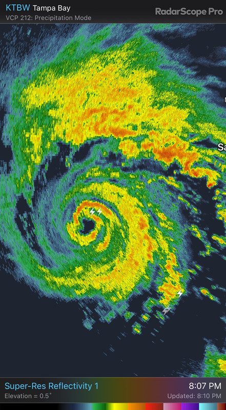
SpaceyLacey wrote:For anyone that asked earlier, around this point Michael was 955mb and 120mph

Sent from my moto g stylus 5G (2022) using Tapatalk


Wow, thanks. So he still did some big numbers after this point to landfall. If I'm in or near the path of this I'm hauling tail.
0 likes   
Personal Forecast Disclaimer:
The posts in this forum are NOT official forecast and should not be used as such. They are just the opinion of the poster and may or may not be backed by sound meteorological data. They are NOT endorsed by any professional institution or storm2k.org. For official information, please refer to the NHC and NWS products.

User avatar
Steve
S2K Supporter
S2K Supporter
Posts: 9621
Joined: Sat Apr 05, 2003 11:41 pm
Location: Not a state-caster

Re: ATL: IDALIA - Hurricane - Discussion

#2509 Postby Steve » Tue Aug 29, 2023 7:19 pm

tolakram wrote:
Highteeld wrote:
tolakram wrote:
It did this last night as well. They are repositioning the floater, which apparently involves more than just simply adjusting the location. :lol:

It would seem so. Very interesting!


And it's back, after taking a trip up the east coast. Repositioned further north.

https://weather.cod.edu/satrad/?parms=meso-meso1-13-24-0-50-1&checked=map&colorbar=undefined


Apparently Idalia did too since they didn’t redraw the map and have it in coastal NJ.
Last edited by Steve on Tue Aug 29, 2023 7:21 pm, edited 1 time in total.
0 likes   

User avatar
PTPatrick
Category 5
Category 5
Posts: 1831
Joined: Sat Jun 12, 2004 8:38 am

Re: ATL: IDALIA - Hurricane - Discussion

#2510 Postby PTPatrick » Tue Aug 29, 2023 7:20 pm

On another note, this looks like it will continue the troubling trend of major gulf storms strengthening up to landfall, after decades of most landfalling as stable or decaying.
2 likes   

User avatar
HurricaneBelle
S2K Supporter
S2K Supporter
Posts: 1179
Joined: Sun Aug 27, 2006 6:12 pm
Location: Clearwater, FL

Re: ATL: IDALIA - Hurricane - Discussion

#2511 Postby HurricaneBelle » Tue Aug 29, 2023 7:21 pm

0 likes   

emeraldislenc
Category 2
Category 2
Posts: 559
Joined: Fri Aug 24, 2012 4:49 pm
Location: Emerald Isle NC

Re: ATL: IDALIA - Hurricane - Discussion

#2512 Postby emeraldislenc » Tue Aug 29, 2023 7:21 pm

No way you can wait 24 hours before storm hits to evacuate people, even in smaller coastal communities can you wait 24 hours before the hurricane hits. You can't blame all the hype on the Weather Channel. Storms are not predictable I think the NHC has done an excellent job!
0 likes   

User avatar
GCANE
S2K Supporter
S2K Supporter
Posts: 11497
Joined: Mon Oct 22, 2007 8:03 am

Re: ATL: IDALIA - Hurricane - Discussion

#2513 Postby GCANE » Tue Aug 29, 2023 7:22 pm

Miss Piggy last reported the eye 12nm wide.
Border line pinhole.
Seeing a large hot tower on the eyewall now.
Pin hole a good possibility
1 likes   

Ken711
Category 5
Category 5
Posts: 1074
Joined: Tue Aug 28, 2012 12:48 pm

Re: ATL: IDALIA - Hurricane - Discussion

#2514 Postby Ken711 » Tue Aug 29, 2023 7:23 pm

0 likes   

User avatar
ElectricStorm
Category 5
Category 5
Posts: 5044
Age: 24
Joined: Tue Aug 13, 2019 11:23 pm
Location: Skiatook, OK / Norman, OK

Re: ATL: IDALIA - Hurricane - Discussion

#2515 Postby ElectricStorm » Tue Aug 29, 2023 7:23 pm

960.6mb extrap
0 likes   
B.S Meteorology, University of Oklahoma '25

Please refer to the NHC, NWS, or SPC for official information.

User avatar
Highteeld
Category 5
Category 5
Posts: 2139
Age: 41
Joined: Tue Jan 30, 2018 9:10 pm
Location: Chicago

Re: ATL: IDALIA - Hurricane - Discussion

#2516 Postby Highteeld » Tue Aug 29, 2023 7:24 pm

GCANE wrote:Miss Piggy last reported the eye 12nm wide.
Border line pinhole.
Seeing a large hot tower on the eyewall now.
Pin hole a good possibility

Pinhole eye brings C4 or C5 back in play. We'll see how this thing actually evolves though. Still seeing hints of dry air on both radar and in dropsonde data.
0 likes   
Very useful information on the Dvorak Technique --

https://severe.worldweather.wmo.int/TCF ... kBeven.pdf

User avatar
Zonacane
Category 1
Category 1
Posts: 361
Joined: Tue Aug 03, 2021 2:23 pm

Re: ATL: IDALIA - Hurricane - Discussion

#2517 Postby Zonacane » Tue Aug 29, 2023 7:24 pm

Highteeld wrote:Some remnant dry air

https://i.imgur.com/bfJ0uRj.png

RH values near 100% is the exact opposite of dry air
2 likes   

User avatar
Highteeld
Category 5
Category 5
Posts: 2139
Age: 41
Joined: Tue Jan 30, 2018 9:10 pm
Location: Chicago

Re: ATL: IDALIA - Hurricane - Discussion

#2518 Postby Highteeld » Tue Aug 29, 2023 7:25 pm

Zonacane wrote:
Highteeld wrote:Some remnant dry air

https://i.imgur.com/bfJ0uRj.png

RH values near 100% is the exact opposite of dry air

It's there in the very lowest levels. A high chance that is why winds aren't mixing down efficiently.
0 likes   
Very useful information on the Dvorak Technique --

https://severe.worldweather.wmo.int/TCF ... kBeven.pdf

User avatar
aspen
Category 5
Category 5
Posts: 8818
Joined: Sat Oct 12, 2019 7:10 pm
Location: Connecticut, USA

Re: ATL: IDALIA - Hurricane - Discussion

#2519 Postby aspen » Tue Aug 29, 2023 7:26 pm

The floater is back on Idalia! Its eye is really warming up now.
0 likes   
Irene '11 Sandy '12 Hermine '16 5/15/2018 Derecho Fay '20 Isaias '20 Elsa '21 Henri '21 Ida '21

I am only a meteorology enthusiast who knows a decent amount about tropical cyclones. Look to the professional mets, the NHC, or your local weather office for the best information.

User avatar
Highteeld
Category 5
Category 5
Posts: 2139
Age: 41
Joined: Tue Jan 30, 2018 9:10 pm
Location: Chicago

Re: ATL: IDALIA - Hurricane - Discussion

#2520 Postby Highteeld » Tue Aug 29, 2023 7:26 pm

Roughly 963 mb now.
0 likes   
Very useful information on the Dvorak Technique --

https://severe.worldweather.wmo.int/TCF ... kBeven.pdf


Return to “2023”

Who is online

Users browsing this forum: No registered users and 4 guests