ATL: IDALIA - Post-Tropical - Discussion

Moderator: S2k Moderators

Message
Author
zzzh
Category 3
Category 3
Posts: 834
Joined: Thu Sep 02, 2021 1:13 pm

Re: ATL: IDALIA - Hurricane - Discussion

#2541 Postby zzzh » Tue Aug 29, 2023 7:35 pm

00962 17025

960mb after conversion.
0 likes   

User avatar
ElectricStorm
Category 5
Category 5
Posts: 5044
Age: 24
Joined: Tue Aug 13, 2019 11:23 pm
Location: Skiatook, OK / Norman, OK

Re: ATL: IDALIA - Hurricane - Discussion

#2542 Postby ElectricStorm » Tue Aug 29, 2023 7:36 pm

Teban54 wrote:
Highteeld wrote:Impressive pressure drop. Could make a case for 959 to 960 mb.

Keep in mind the low pressure bias of the NOAA plane.
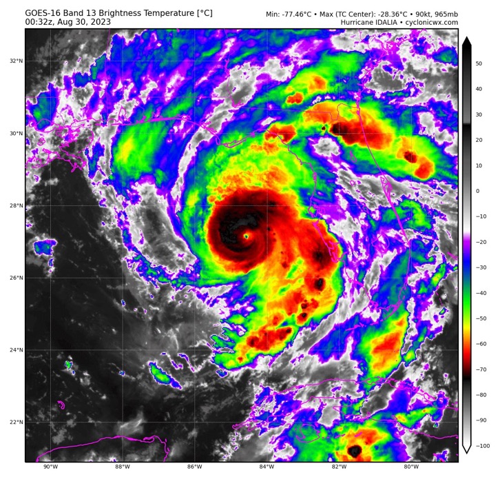
Eye drop is 962/25
1 likes   
B.S Meteorology, University of Oklahoma '25

Please refer to the NHC, NWS, or SPC for official information.

User avatar
aspen
Category 5
Category 5
Posts: 8818
Joined: Sat Oct 12, 2019 7:10 pm
Location: Connecticut, USA

Re: ATL: IDALIA - Hurricane - Discussion

#2543 Postby aspen » Tue Aug 29, 2023 7:36 pm

Visioen wrote:
SFLcane wrote:Eyeball now closed…should go to town now.

Nope, eyeball still open.

https://i.imgur.com/wdgeiWo.png

Look at this huge semicircle band. It won’t take much for that to wrap around the tiny eye and at least attempt to start an EWRC right before landfall.
0 likes   
Irene '11 Sandy '12 Hermine '16 5/15/2018 Derecho Fay '20 Isaias '20 Elsa '21 Henri '21 Ida '21

I am only a meteorology enthusiast who knows a decent amount about tropical cyclones. Look to the professional mets, the NHC, or your local weather office for the best information.

User avatar
GCANE
S2K Supporter
S2K Supporter
Posts: 11497
Joined: Mon Oct 22, 2007 8:03 am

Re: ATL: IDALIA - Hurricane - Discussion

#2544 Postby GCANE » Tue Aug 29, 2023 7:38 pm

Eye rapidly warming on IR
Looks like a pinhole to me
Last edited by GCANE on Tue Aug 29, 2023 7:39 pm, edited 1 time in total.
2 likes   

User avatar
NDG
S2K Supporter
S2K Supporter
Posts: 15446
Joined: Sun Jul 09, 2006 10:14 pm
Location: Orlando, FL

Re: ATL: IDALIA - Hurricane - Discussion

#2545 Postby NDG » Tue Aug 29, 2023 7:39 pm

What a pinhole eye.

Image
6 likes   

User avatar
SFLcane
S2K Supporter
S2K Supporter
Posts: 10163
Age: 47
Joined: Sat Jun 05, 2010 1:44 pm
Location: Lake Worth Florida

Re: ATL: IDALIA - Hurricane - Discussion

#2546 Postby SFLcane » Tue Aug 29, 2023 7:41 pm

Dam, hate to see this but that’s a pinhole eye folks.

Image
Last edited by SFLcane on Tue Aug 29, 2023 7:42 pm, edited 1 time in total.
6 likes   

User avatar
InfernoFlameCat
Category 5
Category 5
Posts: 2102
Age: 22
Joined: Mon Dec 14, 2020 10:52 am
Location: Buford, GA

Re: ATL: IDALIA - Hurricane - Discussion

#2547 Postby InfernoFlameCat » Tue Aug 29, 2023 7:41 pm

It reminds me of Dennis 2004z
0 likes   
I am by no means a professional. DO NOT look at my forecasts for official information or make decisions based on what I post.

Goal: to become a registered expert over tropical and subtropical cyclones.

User avatar
Highteeld
Category 5
Category 5
Posts: 2139
Age: 41
Joined: Tue Jan 30, 2018 9:10 pm
Location: Chicago

Re: ATL: IDALIA - Hurricane - Discussion

#2548 Postby Highteeld » Tue Aug 29, 2023 7:41 pm

Image
2 likes   
Very useful information on the Dvorak Technique --

https://severe.worldweather.wmo.int/TCF ... kBeven.pdf

User avatar
ElectricStorm
Category 5
Category 5
Posts: 5044
Age: 24
Joined: Tue Aug 13, 2019 11:23 pm
Location: Skiatook, OK / Norman, OK

Re: ATL: IDALIA - Hurricane - Discussion

#2549 Postby ElectricStorm » Tue Aug 29, 2023 7:43 pm

VDM still has a ragged eye and open to the W
0 likes   
B.S Meteorology, University of Oklahoma '25

Please refer to the NHC, NWS, or SPC for official information.

User avatar
NDG
S2K Supporter
S2K Supporter
Posts: 15446
Joined: Sun Jul 09, 2006 10:14 pm
Location: Orlando, FL

Re: ATL: IDALIA - Hurricane - Discussion

#2550 Postby NDG » Tue Aug 29, 2023 7:43 pm

Image
7 likes   

User avatar
Highteeld
Category 5
Category 5
Posts: 2139
Age: 41
Joined: Tue Jan 30, 2018 9:10 pm
Location: Chicago

Re: ATL: IDALIA - Hurricane - Discussion

#2551 Postby Highteeld » Tue Aug 29, 2023 7:43 pm

ElectricStorm wrote:VDM still has a ragged eye and open to the W

Radar supported that about 20 minutes ago. Looking a bit fuller now
1 likes   
Very useful information on the Dvorak Technique --

https://severe.worldweather.wmo.int/TCF ... kBeven.pdf

Keldeo1997
Category 2
Category 2
Posts: 637
Joined: Fri Oct 11, 2019 11:35 pm

Re: ATL: IDALIA - Hurricane - Discussion

#2552 Postby Keldeo1997 » Tue Aug 29, 2023 7:43 pm

Image


hmmmm
1 likes   

caneman
Category 5
Category 5
Posts: 1447
Joined: Fri Sep 05, 2014 5:44 am
Location: Clearwater Beach, Fl

Re: ATL: IDALIA - Hurricane - Discussion

#2553 Postby caneman » Tue Aug 29, 2023 7:43 pm

Waterspout off Manasota key moving North
0 likes   

User avatar
GCANE
S2K Supporter
S2K Supporter
Posts: 11497
Joined: Mon Oct 22, 2007 8:03 am

Re: ATL: IDALIA - Hurricane - Discussion

#2554 Postby GCANE » Tue Aug 29, 2023 7:44 pm

Based on what I was seeing yesterday with insane CAPE values in the east GOM and now relatively low values away from Idalia coupled with 4000 in the core, I would saw Idalia sucked it all into its core.
1 likes   

User avatar
ElectricStorm
Category 5
Category 5
Posts: 5044
Age: 24
Joined: Tue Aug 13, 2019 11:23 pm
Location: Skiatook, OK / Norman, OK

Re: ATL: IDALIA - Hurricane - Discussion

#2555 Postby ElectricStorm » Tue Aug 29, 2023 7:45 pm

Highteeld wrote:
ElectricStorm wrote:VDM still has a ragged eye and open to the W

Radar supported that about 20 minutes ago. Looking a bit fuller now

Yeah I agree
0 likes   
B.S Meteorology, University of Oklahoma '25

Please refer to the NHC, NWS, or SPC for official information.

User avatar
InfernoFlameCat
Category 5
Category 5
Posts: 2102
Age: 22
Joined: Mon Dec 14, 2020 10:52 am
Location: Buford, GA

Re: ATL: IDALIA - Hurricane - Discussion

#2556 Postby InfernoFlameCat » Tue Aug 29, 2023 7:45 pm

Am I late to the pinhole train?
This seriously means we could get a cat 5 outta this if it deepens fast enough.
0 likes   
I am by no means a professional. DO NOT look at my forecasts for official information or make decisions based on what I post.

Goal: to become a registered expert over tropical and subtropical cyclones.

User avatar
Highteeld
Category 5
Category 5
Posts: 2139
Age: 41
Joined: Tue Jan 30, 2018 9:10 pm
Location: Chicago

Re: ATL: IDALIA - Hurricane - Discussion

#2557 Postby Highteeld » Tue Aug 29, 2023 7:46 pm

Pinhole eye looking more obvious by the minute

Image
3 likes   
Very useful information on the Dvorak Technique --

https://severe.worldweather.wmo.int/TCF ... kBeven.pdf

tolakram
Admin
Admin
Posts: 20009
Age: 62
Joined: Sun Aug 27, 2006 8:23 pm
Location: Florence, KY (name is Mark)

Re: ATL: IDALIA - Hurricane - Discussion

#2558 Postby tolakram » Tue Aug 29, 2023 7:47 pm

saved loop
Image
4 likes   
M a r k
- - - - -
Join us in chat: Storm2K Chatroom Invite. Android and IOS apps also available.

The posts in this forum are NOT official forecasts and should not be used as such. Posts are NOT endorsed by any professional institution or STORM2K.org. For official information and forecasts, please refer to NHC and NWS products.

Chris90
Category 2
Category 2
Posts: 646
Age: 35
Joined: Thu Jun 01, 2017 9:36 pm

Re: ATL: IDALIA - Hurricane - Discussion

#2559 Postby Chris90 » Tue Aug 29, 2023 7:47 pm

Highteeld wrote:Dry air shows itself again. May take a couple hours to mix it out.

https://i.imgur.com/95nVsSJ.png


I think you might be reading the dropsondes wrong. It's not showing dry air. As the sonde descends it is showing 90% - 79% - 96% relative humidity. It's not dry.

I think you may be looking at the purple colors and thinking the lighter colors are indicating drier air. The purples just get darker the stronger the winds get the way TT depicts them.
6 likes   
Solar Aquarian
Lunar Cancerian
:uarrow: Sagittarian

User avatar
GCANE
S2K Supporter
S2K Supporter
Posts: 11497
Joined: Mon Oct 22, 2007 8:03 am

Re: ATL: IDALIA - Hurricane - Discussion

#2560 Postby GCANE » Tue Aug 29, 2023 7:48 pm

Relatively weak STP now in Tampa Bay and south inland.
Expect this to quickly ramp up with the heavy band coming onshore
0 likes   


Return to “2023”

Who is online

Users browsing this forum: No registered users and 1 guest