ATL: IDALIA - Post-Tropical - Discussion
Moderator: S2k Moderators
-
Hurrilurker

- Category 2

- Posts: 738
- Joined: Mon Jun 09, 2003 3:32 pm
- Location: San Francisco, CA
Re: ATL: IDALIA - Hurricane - Discussion
Seems like it's having trouble clearing out the eye and keeping it that way?
0 likes
-
PavelGaborik10
- Category 1

- Posts: 472
- Joined: Tue Sep 04, 2018 3:23 pm
Re: ATL: IDALIA - Hurricane - Discussion
Hurrilurker wrote:Seems like it's having trouble clearing out the eye and keeping it that way?
That tends to happen when massive bursts of convection are firing continuously.
3 likes

Re: ATL: IDALIA - Hurricane - Discussion
Tekken_Guy wrote:I don’t think Idalia can reach Cat 5 thankfully. Ian was already a 120mph major at midnight on September 28th and Michael was at Cat 4 status by Midnight on October 10th, and Idalia is closer to landfall than either Ian or Michael were at midnight on the day they hit.
Michael made landfall around 1pm central (2pm eastern), and Ian around noon eastern. Idalia’s aiming for a 7-8am landfall.
Not that I'm disagreeing with your main point, but a couple things to add: (All times are in ET unless otherwise specified)
- Ian's peak intensity of 140 kt was achieved at 12z (8am ET), similar to Idalia's projected landfall time, and it intensified from 120 kt at 2am. It weakened from then onwards before the landfall at 3:05pm.
- Michael made landfall at 1:30pm at its peak intensity of 140 kt. At 2am, it was also at 120 kt, and intensified to 125 kt six hours later.
- Idalia has a very small eye, much smaller than Ian's, and probably smaller than Michael's (not sure). This means Idalia can potentially experience even more rapid changes in intensity.
- Charley may be a better comparison to Idalia due to the eye size. Its intensities were: 95 kt at 8am, 110 kt at 10am, 125 kt at 1pm, and 130 kt at 3:45pm (landfall).
- NHC's intensity for Idalia is 95 kt at 11pm, and 115 kt forecast at landfall at 8am. It has 9 hours starting from the NHC advisory, and a bit less than 7 hours from this comment.
Last edited by Teban54 on Wed Aug 30, 2023 1:08 am, edited 2 times in total.
5 likes
TC naming lists: retirements and intensity
Most aggressive Advisory #1's in North Atlantic (cr. kevin for starting the list)
Most aggressive Advisory #1's in North Atlantic (cr. kevin for starting the list)
-
hohnywx
- Category 2
- Posts: 511
- Age: 35
- Joined: Sun Jul 19, 2009 8:34 pm
- Location: Hastings-on-Hudson, NY
Re: ATL: IDALIA - Hurricane - Discussion
https://twitter.com/tresislandfl/status/1696753899015729658
https://twitter.com/sheriffpinellas/status/1696753554730442969
https://twitter.com/sheriffpinellas/status/1696753554730442969
Last edited by hohnywx on Wed Aug 30, 2023 12:21 am, edited 1 time in total.
0 likes


Re: ATL: IDALIA - Hurricane - Discussion
Hurrilurker wrote:Seems like it's having trouble clearing out the eye and keeping it that way?
Off and on yeah. Looks like there is an in-feed about to circle the eye from the NE. Might be transient and just in the flow but could lead to another bursting phenomenon.
https://www.tropicaltidbits.com/sat/sat ... product=ir
Last edited by Steve on Wed Aug 30, 2023 12:23 am, edited 1 time in total.
1 likes

Re: ATL: IDALIA - Hurricane - Discussion
Craters wrote:brad512 wrote:sweetpea wrote:
Pretty much all of the counties Wakulla, Franklin, jefferson, Taylor and Dixie issued a mandatory evacuation south of 98. Everyone is gone for the most part. Even though it is usually really dark here, driving at night sucks.
FWIW, last Fall when Fiona hit here and about 80% of the province was out of power I looked at satellite floaters/pics like that the night after and it still showed everything being lit up as normal despite the fact that almost nobody had power, so it seems like those night lights aren't actually "live" or something. Just something interesting I noticed.
It could have changed now, but even if after this makes landfall and wipes out the power there it seems like those images don't show the changes in the lights.
Unless I'm mistaken, the weather satellite loops, etc., pretty much use a "static" background with the lights and stuff in the nighttime frames. The pictures like this one taken from the space station, though, are "what they see is what they photograph." That is, the lights, clouds, and everything else in the frame is real and was there when they took the picture.
Unless, of course, you're a Flat Earther. Then there are other problems that have to be dealt with.
I figured the weather loops had used some sort of static "filter" or something of the sort as they are more focused on the clouds and storms. I don't think we ever got a real-time before/after light shot released up here but some of those image websites are a bit tricky to navigate at times
2 likes
My Storms:
Earl 2010, Arthur 2014, Dorian 2019, Teddy 2020 and Fiona 2022
Storms that had a major impact on my area are bolded.
Earl 2010, Arthur 2014, Dorian 2019, Teddy 2020 and Fiona 2022
Storms that had a major impact on my area are bolded.
-
Sciencerocks
- Category 5

- Posts: 10193
- Age: 40
- Joined: Thu Jul 06, 2017 1:51 am

-
cheezyWXguy

- Category 5
- Posts: 6282
- Joined: Mon Feb 13, 2006 12:29 am
- Location: Dallas, TX
Re: ATL: IDALIA - Hurricane - Discussion
Eyewall lightning has seen a serious uptick in the last 10 min or so, and radar velocities are increasing
1 likes
-
ElectricStorm

- Category 5
- Posts: 5157
- Age: 25
- Joined: Tue Aug 13, 2019 11:23 pm
- Location: Norman, OK
Re: ATL: IDALIA - Hurricane - Discussion
I'm thinking recon finds a similar pressure to the last mission, maybe a couple mb lower. Winds slightly higher to support 100kts. We'll see
EDIT: never mind
EDIT: never mind
Last edited by ElectricStorm on Wed Aug 30, 2023 12:39 am, edited 1 time in total.
1 likes
B.S Meteorology, University of Oklahoma '25
Please refer to the NHC, NWS, or SPC for official information.
Please refer to the NHC, NWS, or SPC for official information.

-
ElectricStorm
- Category 5
- Posts: 5157
- Age: 25
- Joined: Tue Aug 13, 2019 11:23 pm
- Location: Norman, OK
Re: ATL: IDALIA - Hurricane - Discussion
Oh 
0 likes
B.S Meteorology, University of Oklahoma '25
Please refer to the NHC, NWS, or SPC for official information.
Please refer to the NHC, NWS, or SPC for official information.
-
cheezyWXguy
- Category 5
- Posts: 6282
- Joined: Mon Feb 13, 2006 12:29 am
- Location: Dallas, TX
Re: ATL: IDALIA - Hurricane - Discussion
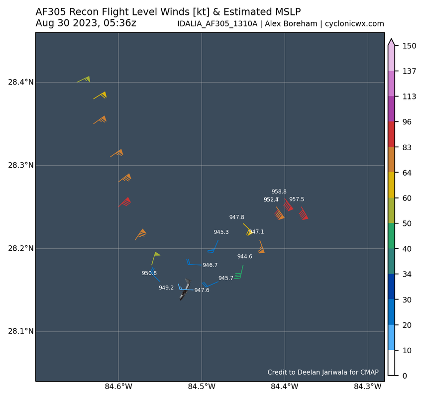
wx98 wrote:Well…944 extrapolated
Yet winds didn't come up?? 944mb compact cat2??
0 likes
-
weeniepatrol

- Category 5
- Posts: 1345
- Joined: Sat Aug 22, 2020 5:30 pm
- Location: WA State

Re: ATL: IDALIA - Hurricane - Discussion
Ianswfl wrote:wx98 wrote:Well…944 extrapolated
Yet winds didn't come up?? 944mb compact cat2??
Northern eyewall. Not the strongest side.
0 likes
-
ElectricStorm
- Category 5
- Posts: 5157
- Age: 25
- Joined: Tue Aug 13, 2019 11:23 pm
- Location: Norman, OK
Re: ATL: IDALIA - Hurricane - Discussion
Ianswfl wrote:wx98 wrote:Well…944 extrapolated
Yet winds didn't come up?? 944mb compact cat2??
That's just one quad they haven't sampled the whole storm yet.
Also that N/NW side is quite a bit stronger than earlier
1 likes
B.S Meteorology, University of Oklahoma '25
Please refer to the NHC, NWS, or SPC for official information.
Please refer to the NHC, NWS, or SPC for official information.
-
CrazyC83
- Professional-Met

- Posts: 34316
- Joined: Tue Mar 07, 2006 11:57 pm
- Location: Deep South, for the first time!
Re: ATL: IDALIA - Hurricane - Discussion
Now we need to get the plane east of the center.
I'd put the intensity at 105 kt at the advisory, out of respect of radar and the pressure drop. It might be stronger once the plane goes all over.
I'd put the intensity at 105 kt at the advisory, out of respect of radar and the pressure drop. It might be stronger once the plane goes all over.
1 likes
Who is online
Users browsing this forum: No registered users and 61 guests