Not bad here. Peak winds from my station 43.4 now 18. 2.34 in much needed rain with no flooding.
Rough surf and rip tides but they will be gone by Saturday.
All in all faired well. US should have a couple weeks off before any other threat.
ATL: IDALIA - Post-Tropical - Discussion
Moderator: S2k Moderators
-
OuterBanker
- S2K Supporter

- Posts: 1761
- Joined: Wed Feb 26, 2003 10:53 am
- Location: Nags Head, NC
- Contact:
-
Sciencerocks
- Category 5

- Posts: 10193
- Age: 40
- Joined: Thu Jul 06, 2017 1:51 am

-
WalterWhite

- Category 1

- Posts: 342
- Joined: Fri Mar 17, 2023 5:53 pm
Re: ATL: IDALIA - Tropical Storm - Discussion
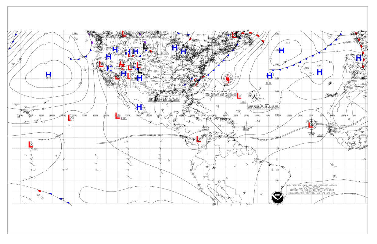
Surface analysis clearly shows Idalia connected to a frontal boundary. Why has the NHC not designated this as a post-tropical cyclone yet?
0 likes
-
dukeblue219
- S2K Supporter
- Posts: 556
- Joined: Fri Sep 30, 2016 3:52 pm
Re: ATL: IDALIA - Tropical Storm - Discussion
WalterWhite wrote:Surface analysis clearly shows Idalia connected to a frontal boundary. Why has the NHC not designated this as a post-tropical cyclone yet?
https://i.postimg.cc/L6MMC4sB/USA-06Z.gif
I'd bet good money it happens at 5pm.
0 likes

Re: ATL: IDALIA - Tropical Storm - Discussion
wxman57 wrote:As the eyewall started a replacement cycle, all stronger winds lifted above the surface. These strong winds aloft would occasionally dip down to the surface, producing 80-90 mph gusts in areas with sub-39 mph sustained wind. We saw something like that with Rita in 2005 and Lily in 2002.
Is that why weakening storms anecdotally feel like they pack much less of a punch than strengthening storms, even at the same intensity?
0 likes
TC naming lists: retirements and intensity
Most aggressive Advisory #1's in North Atlantic (cr. kevin for starting the list)
Most aggressive Advisory #1's in North Atlantic (cr. kevin for starting the list)
-
CrazyC83
- Professional-Met

- Posts: 34316
- Joined: Tue Mar 07, 2006 11:57 pm
- Location: Deep South, for the first time!
Re: ATL: IDALIA - Tropical Storm - Discussion
I would say it is extratropical right now looking at it. In fact, you could argue it has been since this morning (12Z).
0 likes

Re: ATL: IDALIA - Tropical Storm - Discussion
It is listed as extratropical as of 18z.
23, AL, 10, 2023083118, , BEST, 0, 336N, 744W, 55, 994, EX, 50, NEQ, 0, 0, 60, 80, 1007, 200, 45, 65, 0, L, 0, , 0, 0, IDALIA, M, 0, , 0, 0, 0, 0, genesis-num, 023,
0 likes
Re: ATL: IDALIA - Tropical Storm - Discussion
What amazes me Idalia was a compact storm and caused issues for surge over a wide area. Charley was similar in size and a lot stronger at landfall and before landfall and yet only caused a 7ft surge in a small area.
2 likes
-
Sciencerocks
- Category 5
- Posts: 10193
- Age: 40
- Joined: Thu Jul 06, 2017 1:51 am

-
SconnieCane
- Category 5
- Posts: 1013
- Joined: Thu Aug 02, 2018 5:29 pm
- Location: Madison, WI
Re: ATL: IDALIA - Tropical Storm - Discussion
Ianswfl wrote:What amazes me Idalia was a compact storm and caused issues for surge over a wide area. Charley was similar in size and a lot stronger at landfall and before landfall and yet only caused a 7ft surge in a small area.
Goes to show how surge-prone the Big Bend is. Water just keeps piling up on the right side of a hurricane and has nowhere to go. IIRC Michael was just a little too far away to cause serious issues, and it was just sheer luck for the entire western/Gulf coast of Florida that storms like Wilma and Irma came in a such angles as to put the worst of the surge mostly over uninhabited Everglades. With Ian, the luck ran out.
2 likes
-
cycloneye

- Admin

- Posts: 149719
- Age: 69
- Joined: Thu Oct 10, 2002 10:54 am
- Location: San Juan, Puerto Rico
Re: ATL: IDALIA - Post-Tropical - Discussion
NHC will continue with the advisories even if it is post-tropical. A Tropical Storm Watch has been issued for Bermuda.
0 likes
Visit the Caribbean-Central America Weather Thread where you can find at first post web cams,radars
and observations from Caribbean basin members Click Here
and observations from Caribbean basin members Click Here
-
Iceresistance

- Category 5
- Posts: 9607
- Age: 22
- Joined: Sat Oct 10, 2020 9:45 am
- Location: Tecumseh, OK/Norman, OK
Re: ATL: IDALIA - Post-Tropical - Discussion
cycloneye wrote:NHC will continue with the advisories even if it is post-tropical. A Tropical Storm Watch has been issued for Bermuda.
This is rare to do that for NHC standards
2 likes
Bill 2015 & Beta 2020
Winter 2020-2021
All observations are in Tecumseh, OK unless otherwise noted.
Winter posts are focused mainly for Oklahoma & Texas.
Take any of my forecasts with a grain of salt, refer to the NWS, SPC, and NHC for official information
Never say Never with weather! Because ANYTHING is possible!
Winter 2020-2021
All observations are in Tecumseh, OK unless otherwise noted.
Winter posts are focused mainly for Oklahoma & Texas.
Take any of my forecasts with a grain of salt, refer to the NWS, SPC, and NHC for official information
Never say Never with weather! Because ANYTHING is possible!
-
NXStumpy_Robothing
- Category 1
- Posts: 335
- Age: 25
- Joined: Fri Jun 05, 2020 11:50 pm
- Location: North Georgia
Re: ATL: IDALIA - Tropical Storm - Discussion
wxman57 wrote:Here's a copy of estimated winds and gusts using our GIS stuff. Idalia could be downgraded to a Cat 1 at landfall in the post-storm. Those stronger winds found by recon did not make it down to the surface over Florida. Note that some wind data are missing west of the Peninsula. Should see hurricane force wind west of Tampa, for example.
http://wxman57.com/images/IdaliaObserved.JPG
http://wxman57.com/images/IdaliaGusts.JPG
This is a hilariously bad take.
While there is a serious question over the validity of Idalia's brief foray into C4 status (given the presentation, the radar velocities, the dropsonde data, and the continued propagation of deep convection into the area of highest winds observed by recon at the time and later on radar, I'd personally argue that it briefly reached C4 before dropping back down as the dry tongue, uptick in shear, and EWRC weakened that portion of the eyewall) as discussed by others in this thread, genuinely arguing that Idalia could be downgraded 2 whole categories based off of nonexistent surface OBS is one of the asinine opinions I've ever seen expressed by anyone, much less a degreed met.
The region in which Idalia made landfall is quite sparse, despite being in Florida and along the Gulf Coast. Steinhatchee has a little over a thousand permanent residents; Fish Creek is even smaller; the town in which many storm chasers found themselves in or SE of to capture the core, Perry, has a population of 7000. Cedar Key was too far away to be affected by more than the edge fragments of the outer eyewall. These towns are tiny, isolated, and likely do not possess any sort of OBS capable of withstanding the ferocity of a major hurricane, if it exists at all. Larger cities like Tallahassee, Gainesville, and Valdosta were either too far away from the core or too far inland to even give more than a glance with respect to landfall intensity. I see Perry has an ASOS weather station, but it's clear that it didn't really capture Idalia's RMW, is quite far inland (so land friction would play a much larger role), and yet still recorded sustained winds and gusts higher than what your wind plots would indicate. Valdosta, despite being 70 miles inland, experienced near-hurricane conditions (if not had them outright, despite being to the NW of the eye), something that is incredibly unlikely to happen if Idalia was somehow a C1 at landfall.
Going back to recon vs radar data, there's a decent argument to make that they didn't sample the most potent area of the eyewall, especially after the SE and eastern eyewalls dried up. The highest radar velocities near landfall were primarily observed in the convectively-active northern eyewall, with the western semicircle having slightly slower but still strong returns. In the final hour as the eyewall moved ashore, these radar returns in the northern eyewall were consistently packed with bins at or above 130 mph in the boundary layer (and definitively increased in value, as the inner eyewall briefly reestablished itself), supporting at least 115 mph at 10m based upon normal conversions. This area of the eyewall was also consistently producing -70C or colder cloud tops/bursts, had consistent dbZ well above 40, and was filled with lightning, which is probably a contributing factor as to why the plane stuck to the SE and eastern semicircle from a few hours before until after landfall. This is further supported by storm chaser testimony and the limited OBS that was available here (mostly provided by said chasers), all of which tended to support at least a high-end C2 storm at landfall (if not higher - which I would argue for the current landfall intensity being quite accurate) and a pressure of around 950 mb when it did so.
Moving on to your windplots that you've attached to this comment; it's clear that these graphics do not accurately capture what was actually observed along large swaths of Florida's Gulf coast and further inland - many stations recorded sustained winds and gusts quite higher than what any of these images taken at face value would indicate. I don't know what exactly is causing this discrepancy, but as you mentioned, there's missing wind data, and I'd bet on that absent data as being responsible for the stark difference. These plots also could be limited in terms of what OBS they actually pick up and then "smooth" out the rest based upon model data, which could lead to further issues with accuracy and precision. Obviously, this is all speculation from my side, as I don't know exactly what processes, data assimilation, and general code you utilized to generate these. Although, in an area as OBS-sparse as Apalachee Bay, I'm not sure how much more help OBS data from here would've been. Regardless, based upon these charts and these charts alone, I could see how one could argue that Idalia was not a major hurricane at landfall, but as the saying goes: crappy input = crappy output.
There are many points I could belabor further about Idalia to illustrate its true intensity, and why you're dramatically underestimating it with this comment. The argument over how much land friction and terrain can affect and alter the strength and size of the windfield when compared to open water, both before and after landfall, springs to mind. I could harp on about how the amount of water required to generate a storm surge in Horseshoe Beach of >10 feet AGL would've required a more potent core wind swath than implied by a C1 landfall, even with a high-940s/low-950s MSLP. I could discuss how despite passing further away from Tampa Bay, Idalia still managed to set a storm surge record by nearly a foot, significantly higher than Eta 2020 and Elsa 2021. Storm chaser live observations and measurements, many of which detailed extreme conditions, potent mesovortices burrowing their way to the ground, tornadic circulations enveloped within the greater eyewall flow, and several videos of evidence demonstrating a certain ferocity of wind not evident in landfalling non-major storms could be brought up as well. Even satellite estimates, which don't do well in RI cases under conditions which obscure the inner structure (as was the case here), were supportive of a higher intensity and windspeed than what you stated was possible, and they still were underestimating Idalia according to reliable recon data and the limited OBS. Hell, I could even talk about the destruction of buoys and surge cameras as further evidence of what limited OBS that existed near here most likely not surviving the might of Idalia. But ultimately, I don't think it's necessary, and I've certainly rambled for long enough.
The conclusion I've reached, based upon all available data, is this: any landfall estimates between 95-100kt and 115kt are probably defensible. A landfall of 80kt or weaker simply isn't.
31 likes
Undergraduate Meteorology Student, Georgia Institute of Technology
-
emeraldislenc
- Category 2

- Posts: 602
- Joined: Fri Aug 24, 2012 4:49 pm
- Location: Emerald Isle NC
Re: ATL: IDALIA - Post-Tropical - Discussion
Maybe trying to make a case for earlier prediction of wet sloppy mess! Just joking but I can't see them downgrading to Cat 1.
1 likes
-
wxman57

- Moderator-Pro Met

- Posts: 23175
- Age: 68
- Joined: Sat Jun 21, 2003 8:06 pm
- Location: Houston, TX (southwest)
Re: ATL: IDALIA - Post-Tropical - Discussion
emeraldislenc wrote:Maybe trying to make a case for earlier prediction of wet sloppy mess! Just joking but I can't see them downgrading to Cat 1.
Note that I took down the two graphics showing wind speeds because there was missing data and I couldn't verify the data on them. I don't know if the NHC will downgrade Idalia post-season. Evidence suggests an eyewall replacement cycle began a few hours before landfall. I remember watching Allen in 1980 go from a Cat 5 to a Cat 3 and back again three times. That was the first hurricane I ever predicted as a meteorologist. Eyewall replacement cycles typically result in significantly lower core wind speeds, but the wind field expands. When a hurricane weakens significantly before landfall, the weakening may only be at the surface. The strong winds elevate but can dip down occasionally to produce very strong gusts, much stronger than the sustained wind.
I remember Lily in October of 2002. It was a Cat 4 as it approached Louisiana but weakened to a Cat 1 at landfall. Wind gusts were twice the observed sustained wind. Lafayette, LA reported a 50 mph sustained wind and a 100 mph gust. That's what we saw with Idalia. Relatively low sustained wind compared to the gusts. It was similar with Rita in 2003. One of my forecasters was on a couple of flights doing thesis research just prior to landfall. He said that Rita was weakening significantly prior to landfall, and was likely only a Cat 2 at landfall. It was never downgraded, though, possibly because of all the damage it produced. Like Idalia, though, it produced wind gusts way higher than the sustained wind. Seems to be common with hurricanes whose core is weakening at landfall. Ike in 2008, on the other hand, was strengthening at landfall. It produced stronger wind north of Houston than it did at the coast, or in my part of Houston.
I've been watching the coverage of the damage, and I just don't see evidence of hurricane force sustained wind. I would expect whole trees to be down over a large area, not branches. Shingles should be ripped from houses, houses destroyed by wind. The strongest part of the residual eyewall went right over Perry very shortly after landfall and there was no report of sustained hurricane force winds. I believe an 85 mph gust was reported there. Another odd thing about its track was that the weather stations remained operative. Usually, when a strong hurricane makes landfall we can located it by all the missing observations. This time, there were no (or very few) stations that failed. I was working the Idalia forecasts every day since we started advisories two days before the NHC and I was on duty during landfall. I just could not find any station reporting hurricane force wind and very few with sustained TS wind. Those radar velocities cannot be brought down to the surface without a transport mechanism.
So, I think Idalia's winds may have fallen to 85-95 mph at landfall, maybe a little higher. NHC will never downgrade it due to insufficient evidence. As has been stated, there just weren't enough surface obs near landfall. Perhaps a study of wind damage to vegetation and structures would indicate a possible wind speed. We'll see next April, I guess. In the end, it doesn't really matter if the wind was 60 mph or 100 mph if you're without power and your home is damaged or destroyed. It does matter for the historical record, though.
2 likes
Re: ATL: IDALIA - Post-Tropical - Discussion
wxman57 wrote:emeraldislenc wrote:Maybe trying to make a case for earlier prediction of wet sloppy mess! Just joking but I can't see them downgrading to Cat 1.
Note that I took down the two graphics showing wind speeds because there was missing data and I couldn't verify the data on them. I don't know if the NHC will downgrade Idalia post-season. Evidence suggests an eyewall replacement cycle began a few hours before landfall. I remember watching Allen in 1980 go from a Cat 5 to a Cat 3 and back again three times. That was the first hurricane I ever predicted as a meteorologist. Eyewall replacement cycles typically result in significantly lower core wind speeds, but the wind field expands. When a hurricane weakens significantly before landfall, the weakening may only be at the surface. The strong winds elevate but can dip down occasionally to produce very strong gusts, much stronger than the sustained wind.
I remember Lily in October of 2002. It was a Cat 4 as it approached Louisiana but weakened to a Cat 1 at landfall. Wind gusts were twice the observed sustained wind. Lafayette, LA reported a 50 mph sustained wind and a 100 mph gust. That's what we saw with Idalia. Relatively low sustained wind compared to the gusts. It was similar with Rita in 2003. One of my forecasters was on a couple of flights doing thesis research just prior to landfall. He said that Rita was weakening significantly prior to landfall, and was likely only a Cat 2 at landfall. It was never downgraded, though, possibly because of all the damage it produced. Like Idalia, though, it produced wind gusts way higher than the sustained wind. Seems to be common with hurricanes whose core is weakening at landfall. Ike in 2008, on the other hand, was strengthening at landfall. It produced stronger wind north of Houston than it did at the coast, or in my part of Houston.
I've been watching the coverage of the damage, and I just don't see evidence of hurricane force sustained wind. I would expect whole trees to be down over a large area, not branches. Shingles should be ripped from houses, houses destroyed by wind. The strongest part of the residual eyewall went right over Perry very shortly after landfall and there was no report of sustained hurricane force winds. I believe an 85 mph gust was reported there. Another odd thing about its track was that the weather stations remained operative. Usually, when a strong hurricane makes landfall we can located it by all the missing observations. This time, there were no (or very few) stations that failed. I was working the Idalia forecasts every day since we started advisories two days before the NHC and I was on duty during landfall. I just could not find any station reporting hurricane force wind and very few with sustained TS wind. Those radar velocities cannot be brought down to the surface without a transport mechanism.
So, I think Idalia's winds may have fallen to 85-95 mph at landfall, maybe a little higher. NHC will never downgrade it due to insufficient evidence. As has been stated, there just weren't enough surface obs near landfall. Perhaps a study of wind damage to vegetation and structures would indicate a possible wind speed. We'll see next April, I guess. In the end, it doesn't really matter if the wind was 60 mph or 100 mph if you're without power and your home is damaged or destroyed. It does matter for the historical record, though.
Allen was quite a doozy even more so with it being the first storm you had to forecast as a meteorologist. I’ve heard stories of some people evacuating Galveston due to the possibility of Allen hitting the Upper Texas Coast. Must have been a crazy storm to forecast.
0 likes

Re: RE: Re: ATL: IDALIA - Post-Tropical - Discussion
I was in Perry when what was the "reformed" eye wall went through. I will agree that it was a very messy storm. On the ground it was no different, with very bursty winds. That said I have been through a high end eyewall in Ida and been through a few Cat 1s now. This was definitely closer to Ida than the Cat 1's I've been through. There were multiple buildings I saw destroyed and a even quite a few well constructed homes with damage. A lot of uprooted trees aswell.wxman57 wrote:emeraldislenc wrote:Maybe trying to make a case for earlier prediction of wet sloppy mess! Just joking but I can't see them downgrading to Cat 1.
Note that I took down the two graphics showing wind speeds because there was missing data and I couldn't verify the data on them. I don't know if the NHC will downgrade Idalia post-season. Evidence suggests an eyewall replacement cycle began a few hours before landfall. I remember watching Allen in 1980 go from a Cat 5 to a Cat 3 and back again three times. That was the first hurricane I ever predicted as a meteorologist. Eyewall replacement cycles typically result in significantly lower core wind speeds, but the wind field expands. When a hurricane weakens significantly before landfall, the weakening may only be at the surface. The strong winds elevate but can dip down occasionally to produce very strong gusts, much stronger than the sustained wind.
I remember Lily in October of 2002. It was a Cat 4 as it approached Louisiana but weakened to a Cat 1 at landfall. Wind gusts were twice the observed sustained wind. Lafayette, LA reported a 50 mph sustained wind and a 100 mph gust. That's what we saw with Idalia. Relatively low sustained wind compared to the gusts. It was similar with Rita in 2003. One of my forecasters was on a couple of flights doing thesis research just prior to landfall. He said that Rita was weakening significantly prior to landfall, and was likely only a Cat 2 at landfall. It was never downgraded, though, possibly because of all the damage it produced. Like Idalia, though, it produced wind gusts way higher than the sustained wind. Seems to be common with hurricanes whose core is weakening at landfall. Ike in 2008, on the other hand, was strengthening at landfall. It produced stronger wind north of Houston than it did at the coast, or in my part of Houston.
I've been watching the coverage of the damage, and I just don't see evidence of hurricane force sustained wind. I would expect whole trees to be down over a large area, not branches. Shingles should be ripped from houses, houses destroyed by wind. The strongest part of the residual eyewall went right over Perry very shortly after landfall and there was no report of sustained hurricane force winds. I believe an 85 mph gust was reported there. Another odd thing about its track was that the weather stations remained operative. Usually, when a strong hurricane makes landfall we can located it by all the missing observations. This time, there were no (or very few) stations that failed. I was working the Idalia forecasts every day since we started advisories two days before the NHC and I was on duty during landfall. I just could not find any station reporting hurricane force wind and very few with sustained TS wind. Those radar velocities cannot be brought down to the surface without a transport mechanism.
So, I think Idalia's winds may have fallen to 85-95 mph at landfall, maybe a little higher. NHC will never downgrade it due to insufficient evidence. As has been stated, there just weren't enough surface obs near landfall. Perhaps a study of wind damage to vegetation and structures would indicate a possible wind speed. We'll see next April, I guess. In the end, it doesn't really matter if the wind was 60 mph or 100 mph if you're without power and your home is damaged or destroyed. It does matter for the historical record, though.
I was questioning what we were even going to see on the ground before that Northern eyewall rolled through. I can vouch for its intensity. The Northern and Western eyewall had a lot of bite and they were translating downwards. No doubt in my mind this wasn't atleast a Category 2 rolling through there. Unfortunately my Kestrel crapped the bed 1/3 into the storm, so I wasn't able to get any readings.
6 likes

Re: ATL: IDALIA - Post-Tropical - Discussion
It’s definitely an odd storm but I agree with idea that winds often just fail to mix down in these late erc storms. As hard as it is to wrap your mind around how rapidly these can deepen, they can weaken even faster. I imagine the residents of Perry are glad it underperformed.
Some Keaton beach photos look like there was tons of surge but wind damage maybe closer to cat 2 gusts. It kind of reminds me of damage in my area after we had in decaying cat 2 Georges in 1998: some wind damage to roofs, an occasional demolished shed, warehouse, or gas station canopy, big limbs, and a lot of surge. Maybe some mangrove or swamp saw sustained 111 mph wind but I guess we will never know. I imagine the NHC will give it the benefit of the doubt on cat 3 but the gators won’t care.
Try as we might these these things sometimes just don’t fit in the category boxes we want to put them. Even with all the instruments and recon in the world, they are like snowflakes with infinite and quickly changing variables that change the perceptible impacts.
1 likes
Re: RE: Re: ATL: IDALIA - Post-Tropical - Discussion
Sure they didn't mix down to the surface in the Eastern and Southern parts, but the others were very convectively active. These are two seperate bins from the two closest radars. Both samples are happening in areas with convection as noted by the reflectivity. I understand the doubt because the storm transformed big time, but it did come ripping back. We saw this on the groundPTPatrick wrote:It’s definitely an odd storm but I agree with idea that winds often just fail to mix down in these late erc storms. As hard as it is to wrap your mind around how rapidly these can deepen, they can weaken even faster. I imagine the residents of Perry are glad it underperformed.
Some Keaton beach photos look like there was tons of surge but wind damage maybe closer to cat 2 gusts. It kind of reminds me of damage in my area after we had in decaying cat 2 Georges in 1998: some wind damage to roofs, an occasional demolished shed, warehouse, or gas station canopy, big limbs, and a lot of surge. Maybe some mangrove or swamp saw sustained 111 mph wind but I guess we will never know. I imagine the NHC will give it the benefit of the doubt on cat 3 but the gators won’t care.
Try as we might these these things sometimes just don’t fit in the category boxes we want to put them. Even with all the instruments and recon in the world, they are like snowflakes with infinite and quickly changing variables that change the perceptible impacts.


5 likes

Re: ATL: IDALIA - Post-Tropical - Discussion
Just a quick post-storm shout-out to S2K and its admins and pro-mets for being a treasure trove of education and information every season. S2K is my go-to for all things tropical and brings me a real sense of control when systems are bearing down on us here in Florida each year.
(Thankfully, here in Pasco County, I get to benefit from Tampa's forcefield.)
Thanks again,
James (full8s)
(Thankfully, here in Pasco County, I get to benefit from Tampa's forcefield.)
Thanks again,
James (full8s)
6 likes
"All I know is that I don't know nothin'..."
Who is online
Users browsing this forum: No registered users and 55 guests