2023 Indicators (SST, SAL, MSLP, Wind shear, Steering, Instability) and Day 16+ Models
Moderator: S2k Moderators
Forum rules

The posts in this forum are NOT official forecasts and should not be used as such. They are just the opinion of the poster and may or may not be backed by sound meteorological data. They are NOT endorsed by any professional institution or STORM2K. For official information, please refer to products from the National Hurricane Center and National Weather Service.
-
Category5Kaiju

- Category 5

- Posts: 4346
- Joined: Thu Dec 24, 2020 12:45 pm
- Location: Seattle during the summer, Phoenix during the winter
Re: 2023 Indicators (SST, SAL, MSLP, Wind shear, Steering, Instability) and Day 16+ Models
Another thing I will remember even after this season is done is to really be careful of the GFS, especially whenever it is the only model that doesn't develop a particular system. Literally a week ago, the GFS's runs had very little, if any, signs of Idalia. We saw how the GFS desperately played catch up after that. I think part of it is because the GFS has an EPAC bias and Atlantic dry air bias. Something to be mindful of for future years.
5 likes
Unless explicitly stated, all information in my posts is based on my own opinions and observations. Tropical storms and hurricanes can be extremely dangerous. Refer to an accredited weather research agency or meteorologist if you need to make serious decisions regarding an approaching storm.


Re: 2023 Indicators (SST, SAL, MSLP, Wind shear, Steering, Instability) and Day 16+ Models
That's a hot take, but it does have reasoning behind it. The Atlantic is warming the fastest of all basins. Warm water creates more rising air. It cannot be understated just how much warmer this year is than average. Last year was the same, and so on. Unless this trend changes its easy to see how the Atlantic becomes more dominant.
1 likes
Re: 2023 Indicators (SST, SAL, MSLP, Wind shear, Steering, Instability) and Day 16+ Models
Tropical Indian Ocean/MC is the one that warms the fastest. Tropical Pacific and tropical Atlantic barely warmed if look at long term trend.
0 likes
Re: 2023 Indicators (SST, SAL, MSLP, Wind shear, Steering, Instability) and Day 16+ Models
New Cansips shows a belt of upper easterlies and much weaker trades across the MDR. September will very likely be above average.
0 likes
-
IsabelaWeather
- Category 1

- Posts: 316
- Age: 36
- Joined: Tue Jul 07, 2020 7:29 am
- Location: Isabela, Puerto Rico
Re: 2023 Indicators (SST, SAL, MSLP, Wind shear, Steering, Instability) and Day 16+ Models
Woofde wrote:That's a hot take, but it does have reasoning behind it. The Atlantic is warming the fastest of all basins. Warm water creates more rising air. It cannot be understated just how much warmer this year is than average. Last year was the same, and so on. Unless this trend changes its easy to see how the Atlantic becomes more dominant.Keldeo1997 wrote:https://twitter.com/DerekOrtt/status/1697327407231889765
I would assume that is because the ATL doesnt have a really cold current like the EPAC? EPAC basically gets water fron the Bering Sea and i Think the Arctic Ocean
0 likes
-
weeniepatrol

- Category 5
- Posts: 1345
- Joined: Sat Aug 22, 2020 5:30 pm
- Location: WA State
Re: 2023 Indicators (SST, SAL, MSLP, Wind shear, Steering, Instability) and Day 16+ Models
Atlantic ACE has crossed 50 (currently 51.2 per CSU) and is now up to 140% of average for the date.
1 likes
-
weeniepatrol
- Category 5
- Posts: 1345
- Joined: Sat Aug 22, 2020 5:30 pm
- Location: WA State
Re: 2023 Indicators (SST, SAL, MSLP, Wind shear, Steering, Instability) and Day 16+ Models
Welcome to September, gang! Should be fairly quiet with a strong El Nin-

never mind
never mind
18 likes
-
hurricanes1234
- Category 5
- Posts: 2908
- Joined: Sat Jul 28, 2012 6:19 pm
- Location: Trinidad and Tobago
Re: 2023 Indicators (SST, SAL, MSLP, Wind shear, Steering, Instability) and Day 16+ Models
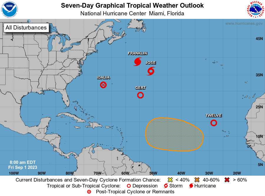
And the plot continues to thicken! With Gert having regenerated at 5 AM, we now have four named systems in close proximity (even though Idalia is technically post-tropical).

6 likes
PLEASE NOTE: With the exception of information from weather agencies that I may copy and paste here, my posts will NEVER be official, since I am NOT a meteorologist. They are solely my amateur opinion, and may or may not be accurate. Therefore, please DO NOT use them as official details, particularly when making important decisions. Thank you.

Re: 2023 Indicators (SST, SAL, MSLP, Wind shear, Steering, Instability) and Day 16+ Models
hurricanes1234 wrote:And the plot continues to thicken! With Gert having regenerated at 5 AM, we now have four named systems in close proximity (even though Idalia is technically post-tropical).
https://i.imgur.com/7c8l9In.png
And to top it off, we get a sample of each symbol used on NHC's maps.
This could almost be like a hurricane season flag of sorts
10 likes
The above post is not official and should not be used as such. It is the opinion of the poster and may or may not be backed by sound meteorological data. It is not endorsed by any professional institution or storm2k.org. For official information, please refer to the NHC and NWS products.
-
Category5Kaiju
- Category 5
- Posts: 4346
- Joined: Thu Dec 24, 2020 12:45 pm
- Location: Seattle during the summer, Phoenix during the winter
Re: 2023 Indicators (SST, SAL, MSLP, Wind shear, Steering, Instability) and Day 16+ Models
We are likely going to have Katia and Lee at some point within the next week or so, which will bring us to 13 nameable storms total.
Please correct me if I am wrong, but I believe no other recorded Atlantic hurricane season that coincided with an El Nino of at least moderate strength was that active, especially by the beginning of September.
Please correct me if I am wrong, but I believe no other recorded Atlantic hurricane season that coincided with an El Nino of at least moderate strength was that active, especially by the beginning of September.
1 likes
Unless explicitly stated, all information in my posts is based on my own opinions and observations. Tropical storms and hurricanes can be extremely dangerous. Refer to an accredited weather research agency or meteorologist if you need to make serious decisions regarding an approaching storm.
Re: 2023 Indicators (SST, SAL, MSLP, Wind shear, Steering, Instability) and Day 16+ Models
A little interesting observation about the TC outbreak we just had, is how the cold wakes are barely even showing up. Usually you would expect a trail of significantly anomalous cold SSTs where a major hurricane has tracked. It's very telling that the wakes only lowered SSTs to average / barely below average.
6 likes

Re: 2023 Indicators (SST, SAL, MSLP, Wind shear, Steering, Instability) and Day 16+ Models
hurricanes1234 wrote:And the plot continues to thicken! With Gert having regenerated at 5 AM, we now have four named systems in close proximity (even though Idalia is technically post-tropical).
https://i.imgur.com/7c8l9In.png
5 systems now.
2 likes
TC naming lists: retirements and intensity
Most aggressive Advisory #1's in North Atlantic (cr. kevin for starting the list)
Most aggressive Advisory #1's in North Atlantic (cr. kevin for starting the list)


Re: 2023 Indicators (SST, SAL, MSLP, Wind shear, Steering, Instability) and Day 16+ Models
zzzh wrote:Tropical Indian Ocean/MC is the one that warms the fastest. Tropical Pacific and tropical Atlantic barely warmed if look at long term trend.
The Indian Ocean gets dominated by easterly shear underneath the monsoonal westerly winds most of the time, that's why their summers are most times tropical cyclone free.
1 likes
Re: 2023 Indicators (SST, SAL, MSLP, Wind shear, Steering, Instability) and Day 16+ Models
Category5Kaiju wrote:We are likely going to have Katia and Lee at some point within the next week or so, which will bring us to 13 nameable storms total.
Please correct me if I am wrong, but I believe no other recorded Atlantic hurricane season that coincided with an El Nino of at least moderate strength was that active, especially by the beginning of September.
Without having time to check now to make sure, that would be my educated guess.
0 likes
Personal Forecast Disclaimer:
The posts in this forum are NOT official forecasts and should not be used as such. They are just the opinion of the poster and may or may not be backed by sound meteorological data. They are NOT endorsed by any professional institution or storm2k.org. For official information, please refer to the NHC and NWS products.
The posts in this forum are NOT official forecasts and should not be used as such. They are just the opinion of the poster and may or may not be backed by sound meteorological data. They are NOT endorsed by any professional institution or storm2k.org. For official information, please refer to the NHC and NWS products.
Re: 2023 Indicators (SST, SAL, MSLP, Wind shear, Steering, Instability) and Day 16+ Models
NDG wrote:zzzh wrote:Tropical Indian Ocean/MC is the one that warms the fastest. Tropical Pacific and tropical Atlantic barely warmed if look at long term trend.
The Indian Ocean gets dominated by easterly shear underneath the monsoonal westerly winds most of the time, that's why their summers are most times tropical cyclone free.
I was talking about long term trend/global warming, don't know what's your point here?
0 likes
Re: 2023 Indicators (SST, SAL, MSLP, Wind shear, Steering, Instability) and Day 16+ Models
Category5Kaiju wrote:We are likely going to have Katia and Lee at some point within the next week or so, which will bring us to 13 nameable storms total.
Please correct me if I am wrong, but I believe no other recorded Atlantic hurricane season that coincided with an El Nino of at least moderate strength was that active, especially by the beginning of September.
Of those moderate+ Niños on record, none have had more than 2 MH by the way.
2 likes
Personal Forecast Disclaimer:
The posts in this forum are NOT official forecasts and should not be used as such. They are just the opinion of the poster and may or may not be backed by sound meteorological data. They are NOT endorsed by any professional institution or storm2k.org. For official information, please refer to the NHC and NWS products.
The posts in this forum are NOT official forecasts and should not be used as such. They are just the opinion of the poster and may or may not be backed by sound meteorological data. They are NOT endorsed by any professional institution or storm2k.org. For official information, please refer to the NHC and NWS products.
-
weeniepatrol
- Category 5
- Posts: 1345
- Joined: Sat Aug 22, 2020 5:30 pm
- Location: WA State
Re: 2023 Indicators (SST, SAL, MSLP, Wind shear, Steering, Instability) and Day 16+ Models
LarryWx wrote:Category5Kaiju wrote:We are likely going to have Katia and Lee at some point within the next week or so, which will bring us to 13 nameable storms total.
Please correct me if I am wrong, but I believe no other recorded Atlantic hurricane season that coincided with an El Nino of at least moderate strength was that active, especially by the beginning of September.
Of those moderate+ Niños on record, none have had more than 2 MH by the way.
It's incredible that we have tied the 2 MH count before September!
1 likes
-
hurricanes1234
- Category 5
- Posts: 2908
- Joined: Sat Jul 28, 2012 6:19 pm
- Location: Trinidad and Tobago
Re: 2023 Indicators (SST, SAL, MSLP, Wind shear, Steering, Instability) and Day 16+ Models
Ah yes, Tropical Storm Franklinose. 

11 likes
PLEASE NOTE: With the exception of information from weather agencies that I may copy and paste here, my posts will NEVER be official, since I am NOT a meteorologist. They are solely my amateur opinion, and may or may not be accurate. Therefore, please DO NOT use them as official details, particularly when making important decisions. Thank you.
-
Category5Kaiju
- Category 5
- Posts: 4346
- Joined: Thu Dec 24, 2020 12:45 pm
- Location: Seattle during the summer, Phoenix during the winter
Re: 2023 Indicators (SST, SAL, MSLP, Wind shear, Steering, Instability) and Day 16+ Models
Due to the sheer stupidity of the name, the name "Franklinose" was retired from the 2023 Atlantic hurricane season and will never be used again for another Atlantic hurricane.
6 likes
Unless explicitly stated, all information in my posts is based on my own opinions and observations. Tropical storms and hurricanes can be extremely dangerous. Refer to an accredited weather research agency or meteorologist if you need to make serious decisions regarding an approaching storm.
-
ScottNAtlanta

- Category 5
- Posts: 2535
- Joined: Sat May 25, 2013 3:11 pm
- Location: Atlanta, GA
Re: 2023 Indicators (SST, SAL, MSLP, Wind shear, Steering, Instability) and Day 16+ Models

Don't just look at anomalies. I hear a lot of talk about how crazy warm the water is of equatorial S America. Five degree anomalies are only 22 C/23 C. If you look at the current SST map above, you see there is a ton more warmth in the Atlantic so it would be hard to maintain upward motion in the EPAC for very long at this point in the season
0 likes
The posts in this forum are NOT official forecast and should not be used as such. They are just the opinion of the poster and may or may not be backed by sound meteorological data. They are NOT endorsed by any professional institution or storm2k.org. For official information, please refer to the NHC and NWS products.
Who is online
Users browsing this forum: Google Adsense [Bot], wwizard and 140 guests