
ATL: LEE - Models
Moderator: S2k Moderators
-
Hypercane_Kyle

- Category 5

- Posts: 3465
- Joined: Sat Mar 07, 2015 7:58 pm
- Location: Cape Canaveral, FL
Re: ATL: INVEST 95L - Models
18z GFS goes against its own ensembles, which still for the most part show development.
0 likes
My posts are my own personal opinion, defer to the National Hurricane Center (NHC) and other NOAA products for decision making during hurricane season.
-
Blown Away

- S2K Supporter

- Posts: 10253
- Joined: Wed May 26, 2004 6:17 am
Re: ATL: INVEST 95L - Models
0 likes
Hurricane Eye Experience: David 79, Irene 99, Frances 04, Jeanne 04, Wilma 05… Hurricane Brush Experience: Andrew 92, Erin 95, Floyd 99, Matthew 16, Irma 17, Ian 22, Nicole 22…
-
AutoPenalti
- Category 5
- Posts: 4091
- Age: 29
- Joined: Mon Aug 17, 2015 4:16 pm
- Location: Ft. Lauderdale, Florida
Re: ATL: INVEST 95L - Models
Even in a weakened state, 95L gets into the Bahamas, stalls and moves away.
0 likes
The posts in this forum are NOT official forecasts and should not be used as such. They are just the opinion of the poster and may or may not be backed by sound meteorological data. They are NOT endorsed by any professional institution or STORM2K. For official information, please refer to products from the NHC and NWS.
Model Runs Cheat Sheet:
GFS (5:30 AM/PM, 11:30 AM/PM)
HWRF, GFDL, UKMET, NAVGEM (6:30-8:00 AM/PM, 12:30-2:00 AM/PM)
ECMWF (1:45 AM/PM)
TCVN is a weighted averaged
Re: ATL: INVEST 95L - Models
AutoPenalti wrote:Even in a weakened state, 95L gets into the Bahamas, stalls and moves away.
0 skill/confidence in steering currents 7+ days out
1 likes
-
gatorcane

- S2K Supporter
- Posts: 23708
- Age: 48
- Joined: Sun Mar 13, 2005 3:54 pm
- Location: Boca Raton, FL
Re: ATL: INVEST 95L - Models
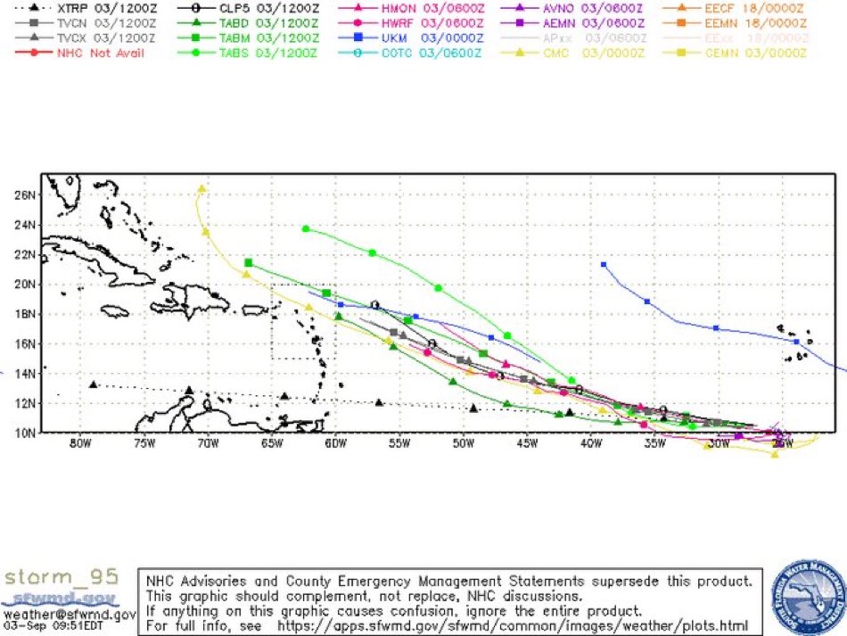
Here is what the experimental FV3 FIM model has. Looks like Global Systems Laboratory is still running this model. I looked back at the track it had for Idalia and it did reasonably well. If you are interested in following this model, which is based on the GFS model fields, here is the link:
https://fim.noaa.gov/FV3new/Welcome.cgi ... 2023+-+12Z
https://fim.noaa.gov/FV3new/Welcome.cgi ... 2023+-+12Z
1 likes

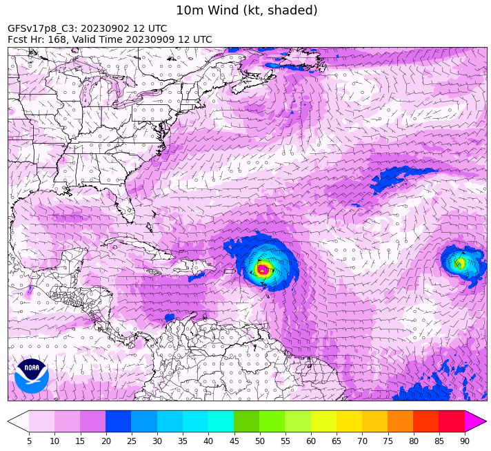
Re: ATL: INVEST 95L - Models
gatorcane wrote:Here is what the experimental FV3 FIM model has. Looks like Global Systems Laboratory is still running this model. I looked back at the track it had for Idalia and it did reasonably well. If you are interested in following this model, which is based on the GFS model fields, here is the link:
https://fim.noaa.gov/FV3new/Welcome.cgi ... 2023+-+12Z
https://i.postimg.cc/bNXqWzJ0/wspeed-WAtlantic-10m-f168.png
There is a trough in the this run between 120 hours and 168 hours it doesn't move much.


0 likes
Re: ATL: INVEST 95L - Models
Beyond 120 hours the ridging 95L is embedded in pushes west.
You can't be sure it won't miss the trough and continue WNW that far out can you?
You can't be sure it won't miss the trough and continue WNW that far out can you?
0 likes
-
gatorcane
- S2K Supporter
- Posts: 23708
- Age: 48
- Joined: Sun Mar 13, 2005 3:54 pm
- Location: Boca Raton, FL
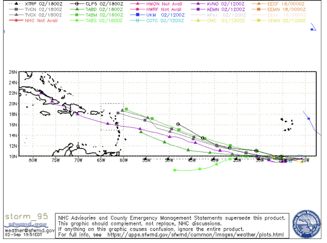
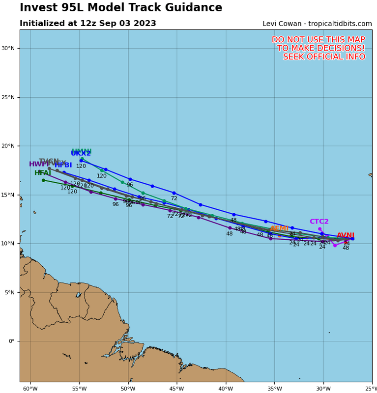
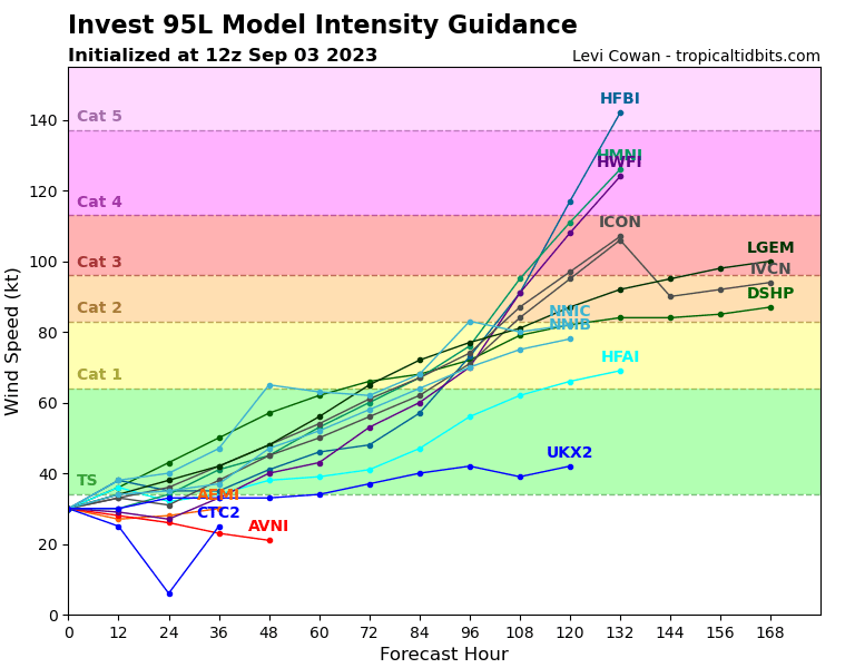
Re: ATL: INVEST 95L - Models
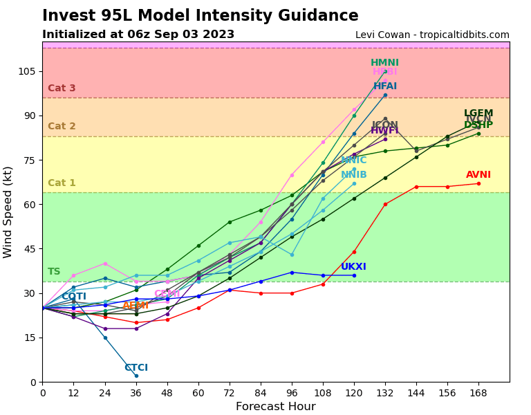
00Z TVCN shifted quite a bit north. Check out the intensity guidance though notably the GFS and UKMET are weak:
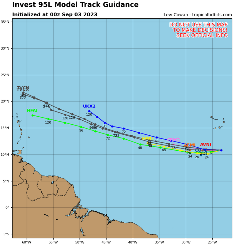
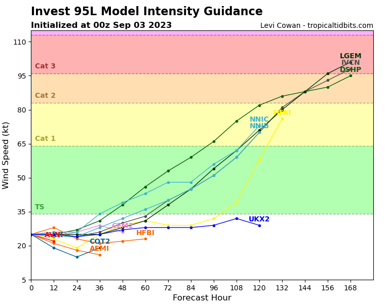
0 likes
Re: ATL: INVEST 95L - Models
gatorcane wrote:00Z TVCN shifted quite a bit north. Check out the intensity guidance though notably the GFS and UKMET are weak:
https://i.postimg.cc/QMpWv6gS/95-L-tracks-latest.png
https://i.postimg.cc/x8dJJnwF/95-L-intensity-00z.png
Good news this run!
2 likes
-
Meteorcane

- Category 2

- Posts: 559
- Joined: Thu Jul 21, 2011 6:49 am
- Location: North Platte Nebraska
Re: ATL: INVEST 95L - Models
position largely unchanged through 120 hours on the 00Z GFS, some modest weakening of the ridging to its north relative to the 12 and 18Z runs, maybe a chance to miss the islands to the north on this run, but not a sure thing.
GFS, after a series of more aggressive runs, back to being very conservative on development of this system. Overall once easterly shear improves in a couple of days and outflow channels become better established, sort of have a hard time believing this system stays so weak (although the EC has backed off on early development as well). The system is so weak and poorly established in this GFS solution that it doesn't even survive its encounters with the Caribbean islands. Once again not too much confidence in that solution (both that far south and that weak).
GFS, after a series of more aggressive runs, back to being very conservative on development of this system. Overall once easterly shear improves in a couple of days and outflow channels become better established, sort of have a hard time believing this system stays so weak (although the EC has backed off on early development as well). The system is so weak and poorly established in this GFS solution that it doesn't even survive its encounters with the Caribbean islands. Once again not too much confidence in that solution (both that far south and that weak).
0 likes
Re: ATL: INVEST 95L - Models
After two runs without TCG being noted on the UKMET, the new run (0Z) has TCG. Together with a much stronger CMC vs 12Z, there is some reversal of recent runs' weakening trends despite the 0Z GFS being similar to its recent weaker runs.
0Z UKMET: moving WNW at 15 just N of Leewards at 168:
NEW TROPICAL CYCLONE FORECAST TO DEVELOP AFTER 84 HOURS
FORECAST POSITION AT T+ 84 : 14.8N 44.0W
LEAD CENTRAL MAXIMUM WIND
VERIFYING TIME TIME POSITION PRESSURE (MB) SPEED (KNOTS)
-------------- ---- -------- ------------- -------------
1200UTC 06.09.2023 84 14.8N 44.0W 1010 24
0000UTC 07.09.2023 96 15.7N 45.9W 1009 27
1200UTC 07.09.2023 108 16.4N 47.8W 1008 29
0000UTC 08.09.2023 120 17.2N 50.6W 1008 26
1200UTC 08.09.2023 132 17.8N 53.7W 1008 29
0000UTC 09.09.2023 144 18.3N 56.3W 1007 27
1200UTC 09.09.2023 156 18.6N 59.6W 1007 31
0000UTC 10.09.2023 168 19.5N 62.1W 1005 32
0 likes
Personal Forecast Disclaimer:
The posts in this forum are NOT official forecasts and should not be used as such. They are just the opinion of the poster and may or may not be backed by sound meteorological data. They are NOT endorsed by any professional institution or storm2k.org. For official information, please refer to the NHC and NWS products.
The posts in this forum are NOT official forecasts and should not be used as such. They are just the opinion of the poster and may or may not be backed by sound meteorological data. They are NOT endorsed by any professional institution or storm2k.org. For official information, please refer to the NHC and NWS products.
-
Meteorcane
- Category 2
- Posts: 559
- Joined: Thu Jul 21, 2011 6:49 am
- Location: North Platte Nebraska
Re: ATL: INVEST 95L - Models
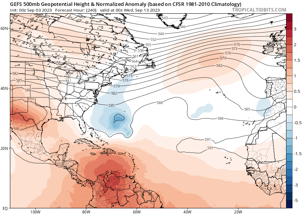
This is not to be unexpected at 240 hours... but these runs really do highlight just how divergent model solutions can be at that time horizon. Note the difference in the 500mb pattern at 240 between the Canadian and the GFS... good reason to not necessarily hug one solution.

2 likes

Re: ATL: INVEST 95L - Models
euro basically the same last few runs, north of the islands before recurving safely up and out
0 likes
-
REDHurricane

- Category 1

- Posts: 438
- Age: 28
- Joined: Sun Jul 03, 2022 2:36 pm
- Location: Northeast Pacific Ocean
Re: ATL: INVEST 95L - Models
EPS 00z has an uncomfortably high number of members showing 95L developing into a major hurricane north of Puerto Rico 8 days out -- I can make out a 927mb, 930mb, two 938mb, two 940mb, two 941mb, 942mb, 943mb, 944mb, two 947mb, and plenty more in the 950-960mb range. Still a long way to go obviously, but even the GEFS has multiple members in the 940-960mb range at the same time, so this will certainly be one to pay close attention to for those who live anywhere in the Caribbean or SE US


0 likes
-
gatorcane
- S2K Supporter
- Posts: 23708
- Age: 48
- Joined: Sun Mar 13, 2005 3:54 pm
- Location: Boca Raton, FL
Re: ATL: INVEST 95L - Models
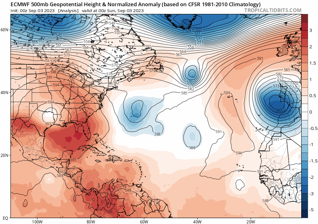
The most consistent model so far has been the ECMWF which has consistently brought the storm just north of the islands on a WNW track where it ultimately slows it down and/or turns it north (see first chart). The 500MB prediction from the Euro has consistently shown a trough over Eastern North America and the Western Atlantic and the other models show it (e.g., see the second chart showing the GEFS mean) as well giving some confidence some kind of weakness should be there, however, still a bit too far out to know for sure.
Check out the intensity guidance this morning which include more models jumping on board for a stronger storm .
.
Check out the intensity guidance this morning which include more models jumping on board for a stronger storm
0 likes
-
Iceresistance

- Category 5
- Posts: 9575
- Age: 22
- Joined: Sat Oct 10, 2020 9:45 am
- Location: Tecumseh, OK/Norman, OK
Re: ATL: INVEST 95L - Models
REDHurricane wrote:EPS 00z has an uncomfortably high number of members showing 95L developing into a major hurricane north of Puerto Rico 8 days out -- I can make out a 927mb, 930mb, two 938mb, two 940mb, two 941mb, 942mb, 943mb, 944mb, two 947mb, and plenty more in the 950-960mb range. Still a long way to go obviously, but even the GEFS has multiple members in the 940-960mb range at the same time, so this will certainly be one to pay close attention to for those who live anywhere in the Caribbean or SE US
https://www.tropicaltidbits.com/analysis/models/eps/2023090300/eps_lowlocs_atl_33.png
https://www.tropicaltidbits.com/analysis/models/gfs-ens/2023090300/gfs-ememb_lowlocs_atl_33.png
In WeatherNerds, there is a 912 mb storm, that is the lowest one I have ever seen from a member on the Euro-ENS
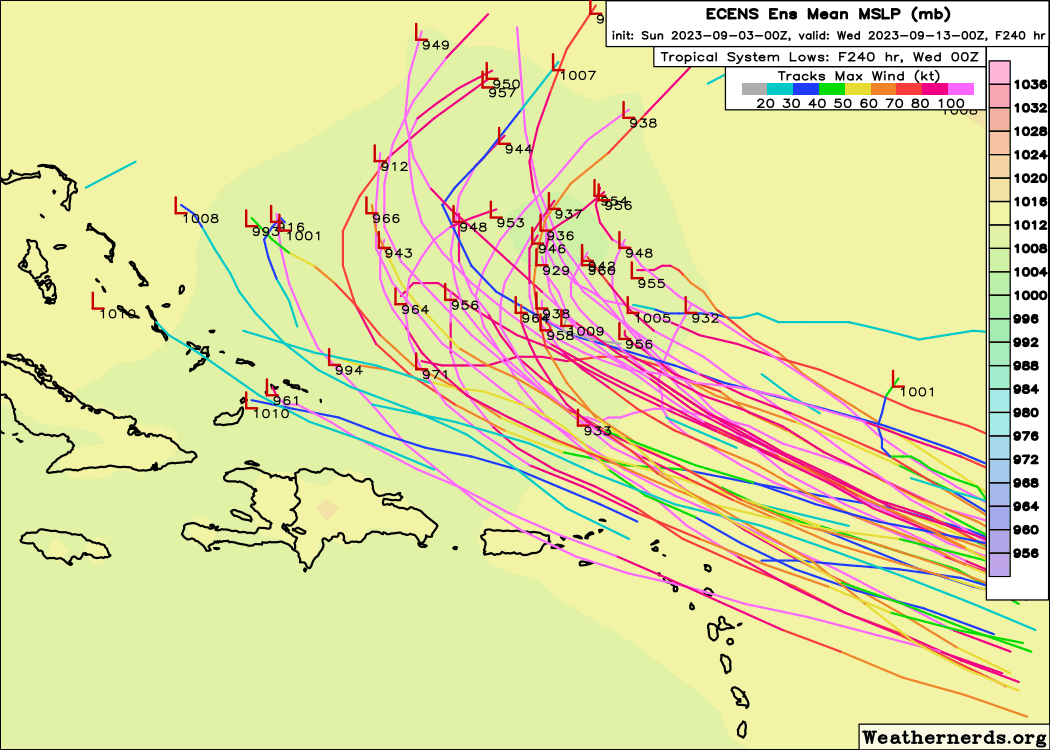
https://s11.gifyu.com/images/SgY94.png
(There is also a 916 between a 993 and a 1001, I didn't notice it until now)
1 likes
Bill 2015 & Beta 2020
Winter 2020-2021
All observations are in Tecumseh, OK unless otherwise noted.
Winter posts are focused mainly for Oklahoma & Texas.
Take any of my forecasts with a grain of salt, refer to the NWS, SPC, and NHC for official information
Never say Never with weather! Because ANYTHING is possible!
Winter 2020-2021
All observations are in Tecumseh, OK unless otherwise noted.
Winter posts are focused mainly for Oklahoma & Texas.
Take any of my forecasts with a grain of salt, refer to the NWS, SPC, and NHC for official information
Never say Never with weather! Because ANYTHING is possible!
-
NotSparta

- Professional-Met

- Posts: 1676
- Age: 24
- Joined: Fri Aug 18, 2017 8:24 am
- Location: Naples, FL
- Contact:
Re: ATL: INVEST 95L - Models
gatorcane wrote:The most consistent model so far has been the ECMWF which has consistently brought the storm just north of the islands on a WNW track where it ultimately slows it down and/or turns it north (see first chart). The 500MB prediction from the Euro has consistently shown a trough over Eastern North America and the Western Atlantic and the other models show it (e.g., see the second chart showing the GEFS mean) as well giving some confidence some kind of weakness should be there, however, still a bit too far out to know for sure.
Check out the intensity guidance this morning which include more models jumping on board for a stronger storm
https://i.postimg.cc/TwZLDd1Q/ec-fast-z500a-Norm-atl-fh0-240.gif
https://i.postimg.cc/mkmfMZNJ/gfs-ens-z500a-Norm-atl-41.png
https://i.postimg.cc/VNn384M6/95-L-intensity-06z.png
Intensity models sure more impressive than a little bit ago where only the unreliable (for invests) statistical models did anything
0 likes
This post was probably an opinion of mine, and in no way is official. Please refer to http://www.hurricanes.gov for official tropical analysis and advisories.
My website, with lots of tropical wx graphics, including satellite and recon: http://cyclonicwx.com
My website, with lots of tropical wx graphics, including satellite and recon: http://cyclonicwx.com
-
gatorcane
- S2K Supporter
- Posts: 23708
- Age: 48
- Joined: Sun Mar 13, 2005 3:54 pm
- Location: Boca Raton, FL
Re: ATL: INVEST 95L - Models
Guidance coming into agreement here with the TVCN track north of the islands. Let’s hope it stays there because check out the new intensity guidance:
4 likes
-
SFLcane

- S2K Supporter
- Posts: 10281
- Age: 48
- Joined: Sat Jun 05, 2010 1:44 pm
- Location: Lake Worth Florida
Re: ATL: INVEST 95L - Models
gatorcane wrote:Guidance coming into agreement here with the TVCN track north of the islands. Let’s hope it stays there because check out the new intensity guidance:
https://i.postimg.cc/1Xgzs077/95-L-tracks-12z.png
https://i.postimg.cc/52PNYRcK/95-L-intensity-12z.png
Bams bending westward..
0 likes
Who is online
Users browsing this forum: No registered users and 7 guests