2023 Indicators (SST, SAL, MSLP, Wind shear, Steering, Instability) and Day 16+ Models

This is the general tropical discussion area. Anyone can take their shot at predicting a storms path.

Moderator: S2k Moderators

Forum rules

The posts in this forum are NOT official forecasts and should not be used as such. They are just the opinion of the poster and may or may not be backed by sound meteorological data. They are NOT endorsed by any professional institution or STORM2K. For official information, please refer to products from the National Hurricane Center and National Weather Service.

Help Support Storm2K
Message
Author
User avatar
weeniepatrol
Category 5
Category 5
Posts: 1273
Joined: Sat Aug 22, 2020 5:30 pm
Location: WA State

Re: 2023 Indicators (SST, SAL, MSLP, Wind shear, Steering, Instability) and Day 16+ Models

#1441 Postby weeniepatrol » Sat Sep 02, 2023 5:36 pm

WalterWhite wrote:
Ntxw wrote:
WalterWhite wrote:
What happened to the West African standing wave, though?


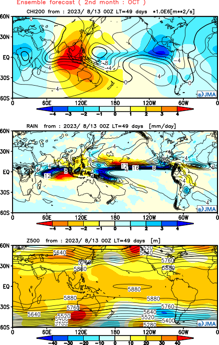
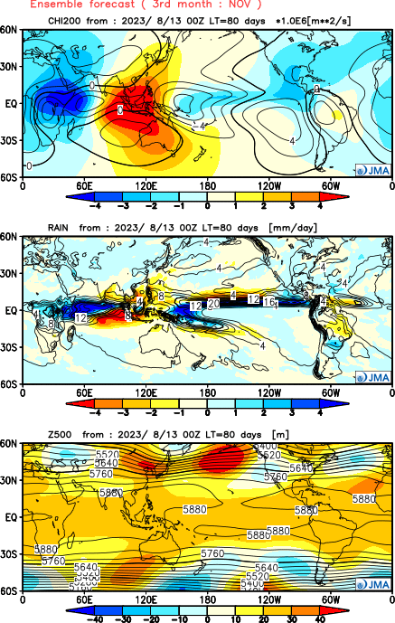
It was neutral-ish until about mid month then became very favorable. Assuming things continue progress, sinking air will return.


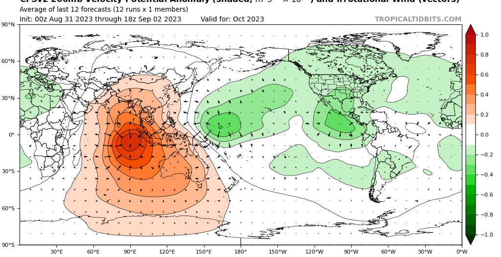
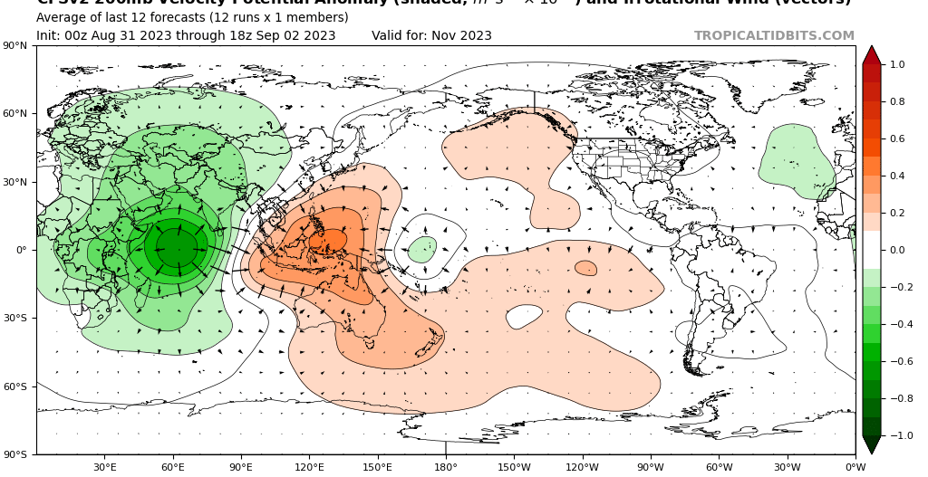
So why is rising air over West Africa not present this year, unlike 2018, 2019, 2020, 2021, and 2022? 2018 and 2019 were +ENSO years, yet they both had a West African standing wave.


This year is a moderate to strong classical/east-Pacific based el Nino; 2018 was much weaker (less amplitude) and modoki/central-Pacific based (-VP anomalies were displaced relative to the canonical el Nino response unlike this year). Additionally 2019 was only warm neutral.
1 likes   

User avatar
canebeard
Tropical Depression
Tropical Depression
Posts: 98
Joined: Sun Jul 05, 2009 4:06 pm
Contact:

Re: 2023 Indicators (SST, SAL, MSLP, Wind shear, Steering, Instability) and Day 16+ Models

#1442 Postby canebeard » Sat Sep 02, 2023 11:13 pm

Looks like some long, swayback dachshund dog about to jump in the ocean to me. How far west can he swim with those tiny legs? Anyone else see this?

Image
3 likes   
List of 79 tropical cyclones intercepted by Richard Horodner:
http://www.canebeard.com/page/page/572246.htm
former storm2k screenname Beoumont 2009+

User avatar
WalterWhite
Category 1
Category 1
Posts: 342
Joined: Fri Mar 17, 2023 5:53 pm

Re: 2023 Indicators (SST, SAL, MSLP, Wind shear, Steering, Instability) and Day 16+ Models

#1443 Postby WalterWhite » Sun Sep 03, 2023 7:47 am

Despite the ongoing strong El Niño, the CFSv2 is showing a favorable background state for Atlantic tropical cyclogenesis in October and November. Rising air over West Africa is favorable for Atlantic development.

Image

Image

The JMA is also indicating the same velocity potential pattern.

Image

Image

These models also, for some reason, seem to be indicating a more favorable background state for November than for October. If that is true, this could possibly be a late-ending hurricane season.
2 likes   

User avatar
WalterWhite
Category 1
Category 1
Posts: 342
Joined: Fri Mar 17, 2023 5:53 pm

Re: 2023 Indicators (SST, SAL, MSLP, Wind shear, Steering, Instability) and Day 16+ Models

#1444 Postby WalterWhite » Sun Sep 03, 2023 8:52 am

tolakram wrote:
WalterWhite wrote:So nature is telling me that third-year La Niñas are less favorable for Atlantic activity than strong El Niños?


I see it in pretty simple terms. Pattern changes are more favorable than stagnant patterns. I don't see this year as being unusual because I see everything in terms of odds. Flip to el nino, pattern change +%. Very good conditions in the Atlantic except for el nino, and right now el nino shear has not been as bad as typically expected (neutral to slightly negative).

I think we've become a little too addicted to SOMETHING OUTRAGEOUS IS HAPPENING. :D


Is there a specific reason as to why you think pattern change years are more favorable?
0 likes   

User avatar
WalterWhite
Category 1
Category 1
Posts: 342
Joined: Fri Mar 17, 2023 5:53 pm

Re: 2023 Indicators (SST, SAL, MSLP, Wind shear, Steering, Instability) and Day 16+ Models

#1445 Postby WalterWhite » Sun Sep 03, 2023 2:43 pm

The models seem to be suggesting:
- Invest 95L developing into Lee, which could become a major hurricane around September 6
- A tropical wave behind that developing into Margot, which will probably be another 50-knot tropical storm around September 8
After this is the realm of fantasyland.
0 likes   

User avatar
cycloneye
Admin
Admin
Posts: 145303
Age: 68
Joined: Thu Oct 10, 2002 10:54 am
Location: San Juan, Puerto Rico

Re: 2023 Indicators (SST, SAL, MSLP, Wind shear, Steering, Instability) and Day 16+ Models

#1446 Postby cycloneye » Sun Sep 03, 2023 4:45 pm

6 likes   
Visit the Caribbean-Central America Weather Thread where you can find at first post web cams,radars
and observations from Caribbean basin members Click Here

User avatar
Teban54
Category 5
Category 5
Posts: 3204
Joined: Sat May 19, 2018 1:19 pm

Re: 2023 Indicators (SST, SAL, MSLP, Wind shear, Steering, Instability) and Day 16+ Models

#1447 Postby Teban54 » Sun Sep 03, 2023 6:18 pm


Notice how 2020 isn't in that list. This means that even though it might feel like this season has too many short-lived slop storms, in reality the storms are reasonably long-lived as seen from the named storm days.
4 likes   

User avatar
Category5Kaiju
Category 5
Category 5
Posts: 4097
Joined: Thu Dec 24, 2020 12:45 pm
Location: Seattle

Re: 2023 Indicators (SST, SAL, MSLP, Wind shear, Steering, Instability) and Day 16+ Models

#1448 Postby Category5Kaiju » Sun Sep 03, 2023 6:27 pm

WalterWhite wrote:The models seem to be suggesting:
- Invest 95L developing into Lee, which could become a major hurricane around September 6
- A tropical wave behind that developing into Margot, which will probably be another 50-knot tropical storm around September 8
After this is the realm of fantasyland.


It's basically not out of the realm of possibilities that this season achieves 14 nameable storms by mid-month or perhaps sooner, which would officially meet the "average" climatological NS count.
1 likes   
Unless explicitly stated, all info in my posts is based on my own opinions and observations. Tropical storms and hurricanes can be extremely dangerous. Do not think you can beat Mother Nature. Refer to an accredited weather research agency or meteorologist if you need to make serious decisions regarding an approaching storm.

User avatar
Hurricane2022
Category 5
Category 5
Posts: 1541
Joined: Tue Aug 23, 2022 11:38 pm
Location: Araçatuba, Brazil

Re: 2023 Indicators (SST, SAL, MSLP, Wind shear, Steering, Instability) and Day 16+ Models

#1449 Postby Hurricane2022 » Sun Sep 03, 2023 8:26 pm

2 likes   
Sorry for the bad English sometimes...!
For reliable and detailed information for any meteorological phenomenon, please consult the National Hurricane Center, Joint Typhoon Warning Center , or your local Meteo Center.

--------

Una cvm Christo, pro Christo, et in Christo. Sit nomen Domini benedictvm.

jconsor
Professional-Met
Professional-Met
Posts: 551
Joined: Mon Jun 30, 2008 9:31 pm
Location: Jerusalem, Israel
Contact:

Re: 2023 Indicators (SST, SAL, MSLP, Wind shear, Steering, Instability) and Day 16+ Models

#1450 Postby jconsor » Mon Sep 04, 2023 6:01 am

Need to be careful. The 1968-1996 shear climo is likely significantly higher for the Caribbean than 1991-2020. If we were to compare Aug 2023 Caribbean shear to 1991-2020, would probably come out just slightly below normal.

CyclonicFury wrote:Caribbean shear was actually BELOW average in August, despite the El Nino.
https://i.imgur.com/JdNHgEq.png

When you average out June-August as a whole, it comes out near to slightly below average.
https://i.imgur.com/rwS5kCb.gif

So far, the model forecasts showing unusually low shear for an El Nino are verifying, which definitely is a factor for why this season has been so active despite El Nino conditions. Both the CFS and CanSIPS are predicting below average shear in the Caribbean/MDR for October and November, so it really makes me question if we'll see a standard Nino early shutdown this year. We've already seen 3 TCs form in or enter the Caribbean Sea this year, when some El Ninos have practically no Caribbean activity at all.
4 likes   

User avatar
WalterWhite
Category 1
Category 1
Posts: 342
Joined: Fri Mar 17, 2023 5:53 pm

Re: 2023 Indicators (SST, SAL, MSLP, Wind shear, Steering, Instability) and Day 16+ Models

#1451 Postby WalterWhite » Mon Sep 04, 2023 8:13 am

jconsor wrote:Need to be careful. The 1968-1996 shear climo is likely significantly higher for the Caribbean than 1991-2020. If we were to compare Aug 2023 Caribbean shear to 1991-2020, would probably come out just slightly below normal.

CyclonicFury wrote:Caribbean shear was actually BELOW average in August, despite the El Nino.
https://i.imgur.com/JdNHgEq.png

When you average out June-August as a whole, it comes out near to slightly below average.
https://i.imgur.com/rwS5kCb.gif

So far, the model forecasts showing unusually low shear for an El Nino are verifying, which definitely is a factor for why this season has been so active despite El Nino conditions. Both the CFS and CanSIPS are predicting below average shear in the Caribbean/MDR for October and November, so it really makes me question if we'll see a standard Nino early shutdown this year. We've already seen 3 TCs form in or enter the Caribbean Sea this year, when some El Ninos have practically no Caribbean activity at all.


That is still unusual for a Strong El Niño year, though. (Yes, I am saying this winter is going to have a Strong El Niño.)
1 likes   

zzzh
Category 3
Category 3
Posts: 834
Joined: Thu Sep 02, 2021 1:13 pm

Re: 2023 Indicators (SST, SAL, MSLP, Wind shear, Steering, Instability) and Day 16+ Models

#1452 Postby zzzh » Mon Sep 04, 2023 8:43 am


Not very uncommon. It happened in 1997 and 2009.
0 likes   

Ianswfl
Category 1
Category 1
Posts: 482
Joined: Thu Mar 23, 2023 11:11 pm

Re: 2023 Indicators (SST, SAL, MSLP, Wind shear, Steering, Instability) and Day 16+ Models

#1453 Postby Ianswfl » Mon Sep 04, 2023 1:42 pm


Makes you wonder if the gulf is still near 80 if we have a late nov or early dec ts into Florida if shear is low. Remember kate 1985.
1 likes   

User avatar
cycloneye
Admin
Admin
Posts: 145303
Age: 68
Joined: Thu Oct 10, 2002 10:54 am
Location: San Juan, Puerto Rico

Re: 2023 Indicators (SST, SAL, MSLP, Wind shear, Steering, Instability) and Day 16+ Models

#1454 Postby cycloneye » Mon Sep 04, 2023 2:21 pm

0 likes   
Visit the Caribbean-Central America Weather Thread where you can find at first post web cams,radars
and observations from Caribbean basin members Click Here

User avatar
weeniepatrol
Category 5
Category 5
Posts: 1273
Joined: Sat Aug 22, 2020 5:30 pm
Location: WA State

Re: 2023 Indicators (SST, SAL, MSLP, Wind shear, Steering, Instability) and Day 16+ Models

#1455 Postby weeniepatrol » Mon Sep 04, 2023 3:11 pm

Image

Image

#lolnino
8 likes   

LarryWx
S2K Supporter
S2K Supporter
Posts: 6305
Joined: Sun Sep 07, 2003 2:04 pm
Location: GA

Re: 2023 Indicators (SST, SAL, MSLP, Wind shear, Steering, Instability) and Day 16+ Models

#1456 Postby LarryWx » Mon Sep 04, 2023 3:15 pm

Whereas the amount of activity to this point has been well above the average for a moderate+ Nino, the steering/tracks seem to have been pretty El Niñoish. Other opinions?
0 likes   
Personal Forecast Disclaimer:
The posts in this forum are NOT official forecasts and should not be used as such. They are just the opinion of the poster and may or may not be backed by sound meteorological data. They are NOT endorsed by any professional institution or storm2k.org. For official information, please refer to the NHC and NWS products.

User avatar
weeniepatrol
Category 5
Category 5
Posts: 1273
Joined: Sat Aug 22, 2020 5:30 pm
Location: WA State

Re: 2023 Indicators (SST, SAL, MSLP, Wind shear, Steering, Instability) and Day 16+ Models

#1457 Postby weeniepatrol » Mon Sep 04, 2023 3:21 pm

LarryWx wrote:Whereas the amount of activity to this point has been well above the average for a moderate+ Nino, the steering/tracks seem to have been pretty El Niñoish. Other opinions?


Definitely agree there! Subtropics just north of the MDR seems especially favored this year (and this is where guidance shows 95L doing most of its deepening and then peaking), as well as recurvature - both seem consistent with the El Nino
3 likes   

LarryWx
S2K Supporter
S2K Supporter
Posts: 6305
Joined: Sun Sep 07, 2003 2:04 pm
Location: GA

Re: 2023 Indicators (SST, SAL, MSLP, Wind shear, Steering, Instability) and Day 16+ Models

#1458 Postby LarryWx » Mon Sep 04, 2023 6:42 pm

weeniepatrol wrote:
LarryWx wrote:Whereas the amount of activity to this point has been well above the average for a moderate+ Nino, the steering/tracks seem to have been pretty El Niñoish. Other opinions?


Definitely agree there! Subtropics just north of the MDR seems especially favored this year (and this is where guidance shows 95L doing most of its deepening and then peaking), as well as recurvature - both seem consistent with the El Nino


As I understand it, steering is based on the wind flow at 500 mb and below whereas shear is produced largely way up at 200 mb or so. So, is it possible that El Niño is behaving closer to normal lower in the atmosphere but not higher up? If so, does that make sense and why would that be?
0 likes   
Personal Forecast Disclaimer:
The posts in this forum are NOT official forecasts and should not be used as such. They are just the opinion of the poster and may or may not be backed by sound meteorological data. They are NOT endorsed by any professional institution or storm2k.org. For official information, please refer to the NHC and NWS products.

SconnieCane
Category 4
Category 4
Posts: 998
Joined: Thu Aug 02, 2018 5:29 pm
Location: Madison, WI

Re: 2023 Indicators (SST, SAL, MSLP, Wind shear, Steering, Instability) and Day 16+ Models

#1459 Postby SconnieCane » Mon Sep 04, 2023 6:55 pm

weeniepatrol wrote:
LarryWx wrote:Whereas the amount of activity to this point has been well above the average for a moderate+ Nino, the steering/tracks seem to have been pretty El Niñoish. Other opinions?


Definitely agree there! Subtropics just north of the MDR seems especially favored this year (and this is where guidance shows 95L doing most of its deepening and then peaking), as well as recurvature - both seem consistent with the El Nino


It's often been said here and on other forums that it was La Nina that strongly favored Eastern troughing and recurves, usually citing 2010 as a classic example.
1 likes   

User avatar
weeniepatrol
Category 5
Category 5
Posts: 1273
Joined: Sat Aug 22, 2020 5:30 pm
Location: WA State

Re: 2023 Indicators (SST, SAL, MSLP, Wind shear, Steering, Instability) and Day 16+ Models

#1460 Postby weeniepatrol » Mon Sep 04, 2023 6:59 pm

LarryWx wrote:
weeniepatrol wrote:
LarryWx wrote:Whereas the amount of activity to this point has been well above the average for a moderate+ Nino, the steering/tracks seem to have been pretty El Niñoish. Other opinions?


Definitely agree there! Subtropics just north of the MDR seems especially favored this year (and this is where guidance shows 95L doing most of its deepening and then peaking), as well as recurvature - both seem consistent with the El Nino


As I understand it, steering is based on the wind flow at 500 mb and below whereas shear is produced largely way up at 200 mb or so. So, is it possible that El Niño is behaving closer to normal lower in the atmosphere but not higher up? If so, does that make sense and why would that be?


Not sure about your question, but steering is dependent on a storms' vertical depth (largely correlated to intensity) - a shallow, weak tropical cyclone will not feel 500mb steering nearly as much as it does surface and low level flow. Shear is largely produced by 200mb winds but can occur at any layer - we have seen prolific easterly shear from strong 20+kt surface trades in light / otherwise conducive upper level flow and prohibitive shear at the mid-levels around 500mb, for example.
1 likes   


Return to “Talkin' Tropics”

Who is online

Users browsing this forum: AnnularCane and 49 guests