ATL: LEE - Models
Moderator: S2k Moderators
Re: ATL: INVEST 95L - Models
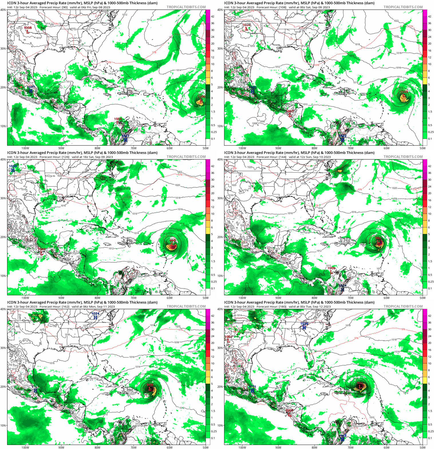
By far the strongest ICON run so far, MH just above the islands at +180 hours. Looks very dangerous.


0 likes
-
Tekken_Guy
- Tropical Storm

- Posts: 150
- Joined: Fri Sep 01, 2017 8:08 pm
Re: ATL: INVEST 95L - Models
ScottNAtlanta wrote:The 6z GFS is the nightmare scenario for NYC. If the GFS were to verify, it would make Sandy look like a walk in the park. I have a very hard time buying into the Euro for the simple reason it has been horrid with the post-tropical Idalia evolution which the GFS has had a better handle on. This is still far out, but don't any of you for one second go calling this a fish or a hit. Both are possible, but in my opinion and from what I see, it is going to be a very close call for something extremely disruptive.
I don’t think the 6z GFS scenario would be as destructive as Sandy and would roughly perform more similarly to Gloria. It’s only at Category 1 status on that one.
1 likes
- Blown Away
- S2K Supporter

- Posts: 10253
- Joined: Wed May 26, 2004 6:17 am
Re: ATL: INVEST 95L - Models
kevin wrote:By far the strongest ICON run so far, MH just above the islands at +180 hours. Looks very dangerous.
https://i.imgur.com/qCVyTt8.png
I lost a little faith in the Icon with Idalia, it was consistently way off with the track.
0 likes
Hurricane Eye Experience: David 79, Irene 99, Frances 04, Jeanne 04, Wilma 05… Hurricane Brush Experience: Andrew 92, Erin 95, Floyd 99, Matthew 16, Irma 17, Ian 22, Nicole 22…
-
jlauderdal
- S2K Supporter

- Posts: 7240
- Joined: Wed May 19, 2004 5:46 am
- Location: NE Fort Lauderdale
- Contact:
Re: ATL: INVEST 95L - Models
SFLcane wrote:https://i.postimg.cc/7Lm0FtB4/IMG-7586.gif
Cycloneye wont like that run
0 likes
- Hypercane_Kyle
- Category 5

- Posts: 3465
- Joined: Sat Mar 07, 2015 7:58 pm
- Location: Cape Canaveral, FL
Re: ATL: INVEST 95L - Models
12z GFS significantly more east, with minimal impact to the Lesser Antilles.
0 likes
My posts are my own personal opinion, defer to the National Hurricane Center (NHC) and other NOAA products for decision making during hurricane season.
Re: ATL: INVEST 95L - Models
Hypercane_Kyle wrote:12z GFS significantly more east, with minimal impact to the Lesser Antilles.
trending strongly toward the more consistant euro here
0 likes
- cycloneye
- Admin

- Posts: 149219
- Age: 69
- Joined: Thu Oct 10, 2002 10:54 am
- Location: San Juan, Puerto Rico
Re: ATL: INVEST 95L - Models
0 likes
Visit the Caribbean-Central America Weather Thread where you can find at first post web cams,radars
and observations from Caribbean basin members Click Here
and observations from Caribbean basin members Click Here
- Iceresistance
- Category 5

- Posts: 9575
- Age: 22
- Joined: Sat Oct 10, 2020 9:45 am
- Location: Tecumseh, OK/Norman, OK
Re: ATL: INVEST 95L - Models
3 likes
Bill 2015 & Beta 2020
Winter 2020-2021
All observations are in Tecumseh, OK unless otherwise noted.
Winter posts are focused mainly for Oklahoma & Texas.
Take any of my forecasts with a grain of salt, refer to the NWS, SPC, and NHC for official information
Never say Never with weather! Because ANYTHING is possible!
Winter 2020-2021

All observations are in Tecumseh, OK unless otherwise noted.
Winter posts are focused mainly for Oklahoma & Texas.
Take any of my forecasts with a grain of salt, refer to the NWS, SPC, and NHC for official information
Never say Never with weather! Because ANYTHING is possible!
- Emmett_Brown
- Category 5

- Posts: 1433
- Joined: Wed Aug 24, 2005 9:10 pm
- Location: Sarasota FL
Re: ATL: INVEST 95L - Models
The GFS is still gyrating wildly regarding run to run for the 500 mb pattern near the Great Lakes after 180 hours. Even though it appears that the GFS is trending toward the Euro, both models have very different upper air patterns over the conus, so any agreement is coincidental. An east conus trough is a good bet based on recent months however. Important for New England will be the tilt of the troughing later in the period which will take about a week before we know.
Last edited by Emmett_Brown on Mon Sep 04, 2023 11:35 am, edited 1 time in total.
4 likes
- Meteorcane
- Category 2

- Posts: 559
- Joined: Thu Jul 21, 2011 6:49 am
- Location: North Platte Nebraska
Re: ATL: INVEST 95L - Models
The Great Lakes closed low setup on the GFS and to a lesser extent the Canadian would put a wrinkle in the easy recurve forecast... but obviously that is in la-la land.
Somehow the GEFS at 12Z is actually less clustered even in the day 4 range than the 06Z GEFS... we will see if the greater spread remains through the length of the forecast.
Somehow the GEFS at 12Z is actually less clustered even in the day 4 range than the 06Z GEFS... we will see if the greater spread remains through the length of the forecast.
0 likes
- gatorcane
- S2K Supporter

- Posts: 23708
- Age: 48
- Joined: Sun Mar 13, 2005 3:54 pm
- Location: Boca Raton, FL
Re: ATL: INVEST 95L - Models
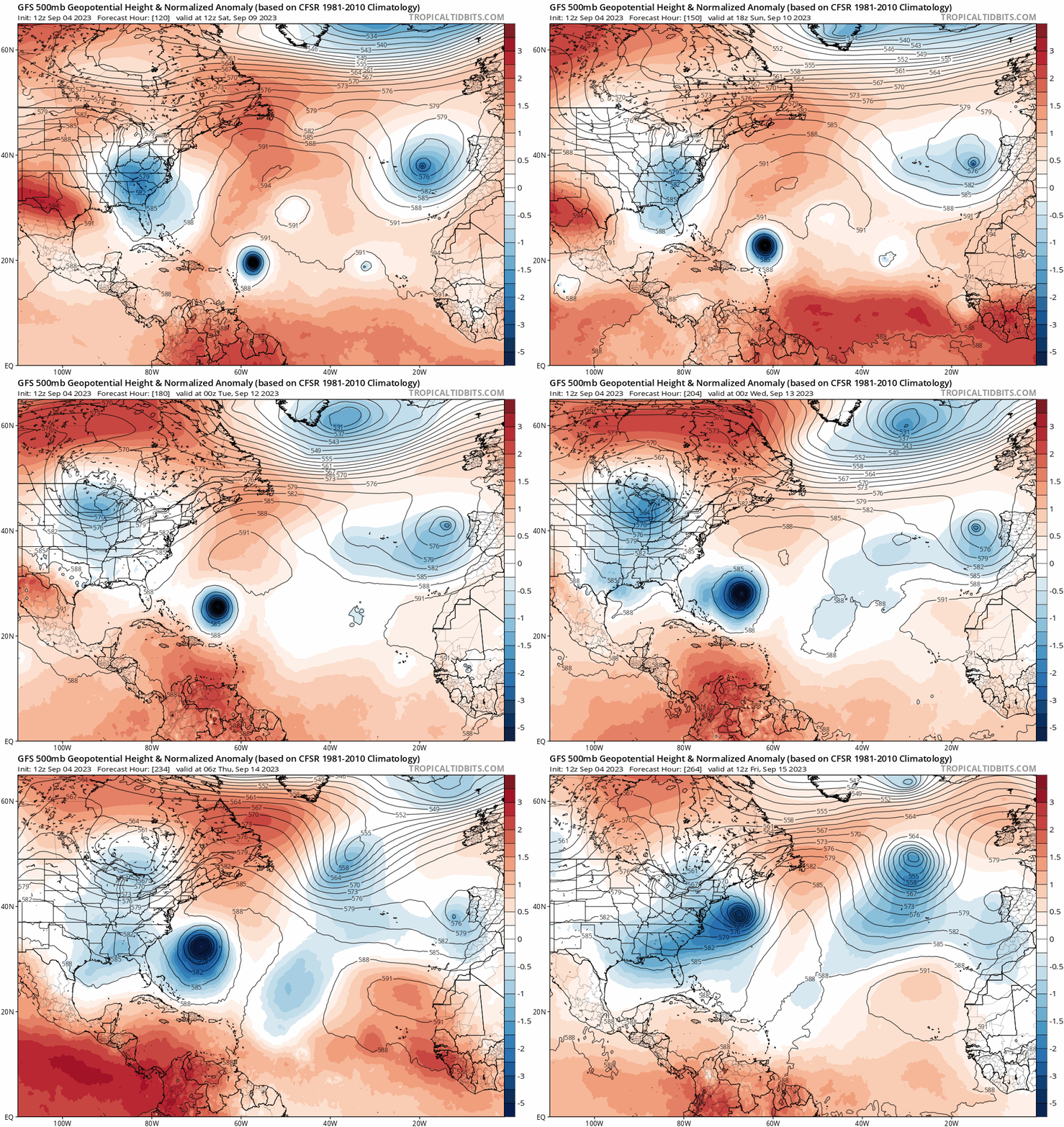
The GFS seems to have a west-bias this year. We saw it for Franklin where it had it hitting Nova Scotia, we saw it with Idalia with it bringing into the FL panhandle, and possibly again with this storm.
The 12Z has shifted east and now is recurving east of the CONUS. While it is too early to say if the CONUS is in the clear, good to see the model shift east like that.
Now Bermuda on the other hand, looks a bit concerning looking at the overall model tracks.
12Z GFS loop from 114 hours:
The 12Z has shifted east and now is recurving east of the CONUS. While it is too early to say if the CONUS is in the clear, good to see the model shift east like that.
Now Bermuda on the other hand, looks a bit concerning looking at the overall model tracks.
12Z GFS loop from 114 hours:

Last edited by gatorcane on Mon Sep 04, 2023 11:49 am, edited 5 times in total.
1 likes
- cheezyWXguy
- Category 5

- Posts: 6280
- Joined: Mon Feb 13, 2006 12:29 am
- Location: Dallas, TX
Re: ATL: INVEST 95L - Models
Anyone writing this off as a fish should take a step back and explore whether they’re really trying to be objective or harping on an emotionally invested outcome.
The thing hasn’t even formed yet, and won’t approach the U.S. east coast for another 8 days. Don’t get too focused on storm tracks for individual deterministic runs. Whether the gfs landfalls it this run, next run, or last run doesn’t really matter at this point. The trends worth watching are at the 500mb level for now, and involve the strength and persistence of the Bermuda high, and the timing and behavior of the east coast trough. The next 5-6 days look pretty locked in, which is most likely good news for the islands. But I’d be paying a bit more attention if I lived on the east coast with all these uncertainties.
The thing hasn’t even formed yet, and won’t approach the U.S. east coast for another 8 days. Don’t get too focused on storm tracks for individual deterministic runs. Whether the gfs landfalls it this run, next run, or last run doesn’t really matter at this point. The trends worth watching are at the 500mb level for now, and involve the strength and persistence of the Bermuda high, and the timing and behavior of the east coast trough. The next 5-6 days look pretty locked in, which is most likely good news for the islands. But I’d be paying a bit more attention if I lived on the east coast with all these uncertainties.
13 likes
- Blown Away
- S2K Supporter

- Posts: 10253
- Joined: Wed May 26, 2004 6:17 am
Re: ATL: INVEST 95L - Models
Meteorcane wrote:The Great Lakes closed low setup on the GFS and to a lesser extent the Canadian would put a wrinkle in the easy recurve forecast... but obviously that is in la-la land.
Somehow the GEFS at 12Z is actually less clustered even in the day 4 range than the 06Z GEFS... we will see if the greater spread remains through the length of the forecast.
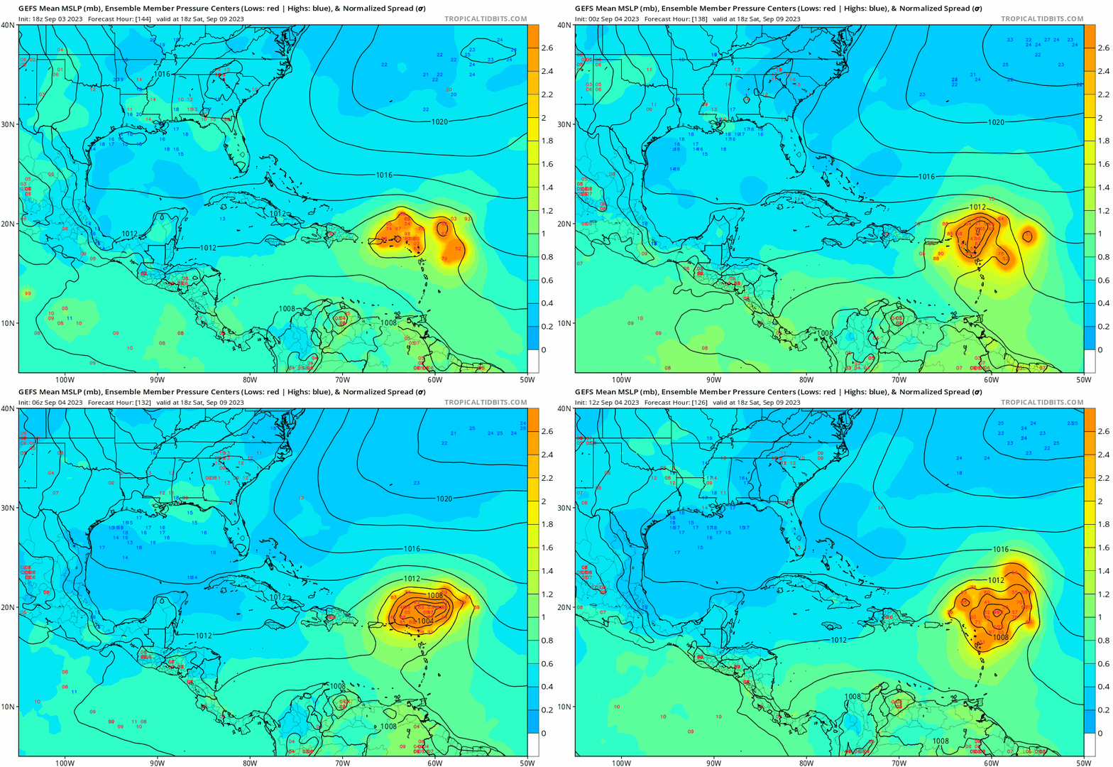
Much broader spread in 12z GEFS.
0 likes
Hurricane Eye Experience: David 79, Irene 99, Frances 04, Jeanne 04, Wilma 05… Hurricane Brush Experience: Andrew 92, Erin 95, Floyd 99, Matthew 16, Irma 17, Ian 22, Nicole 22…
-
hohnywx
- Category 2

- Posts: 511
- Age: 34
- Joined: Sun Jul 19, 2009 8:34 pm
- Location: Hastings-on-Hudson, NY
Re: ATL: INVEST 95L - Models
gatorcane wrote:The GFS seems to have a west-bias this year. We saw it for Franklin where it had it hitting Nova Scotia, we saw it with Idalia with it bringing into the FL panhandle, and possibly again with this storm.
The 12Z has shifted east and now is recurving east of the CONUS. While it is too early to say if the CONUS is in the clear, good to see the model shift east like that.
Now Bermuda on the other hand, looks a bit concerning looking at the overall model tracks.
12Z GFS loop from 114 hours:
https://i.postimg.cc/hj08M4D0/gfs-z500a-Norm-atl-fh120-264.gif
It seems to me that the rapid strengthening the GFS is showing this run (bringing 95L to hurricane status in 60 hours) may also be impacting its track this run.
0 likes
Re: RE: Re: ATL: INVEST 95L - Models
It was off at points, but not sure it was anymore off than any of the others. Euro was too east, GFS too far west. Would have to look at the verification data. Later on the ICON consistently showed it going into Perry.Blown Away wrote:kevin wrote:By far the strongest ICON run so far, MH just above the islands at +180 hours. Looks very dangerous.
https://i.imgur.com/qCVyTt8.png
I lost a little faith in the Icon with Idalia, it was consistently way off with the track.
0 likes
- gatorcane
- S2K Supporter

- Posts: 23708
- Age: 48
- Joined: Sun Mar 13, 2005 3:54 pm
- Location: Boca Raton, FL
Re: ATL: INVEST 95L - Models
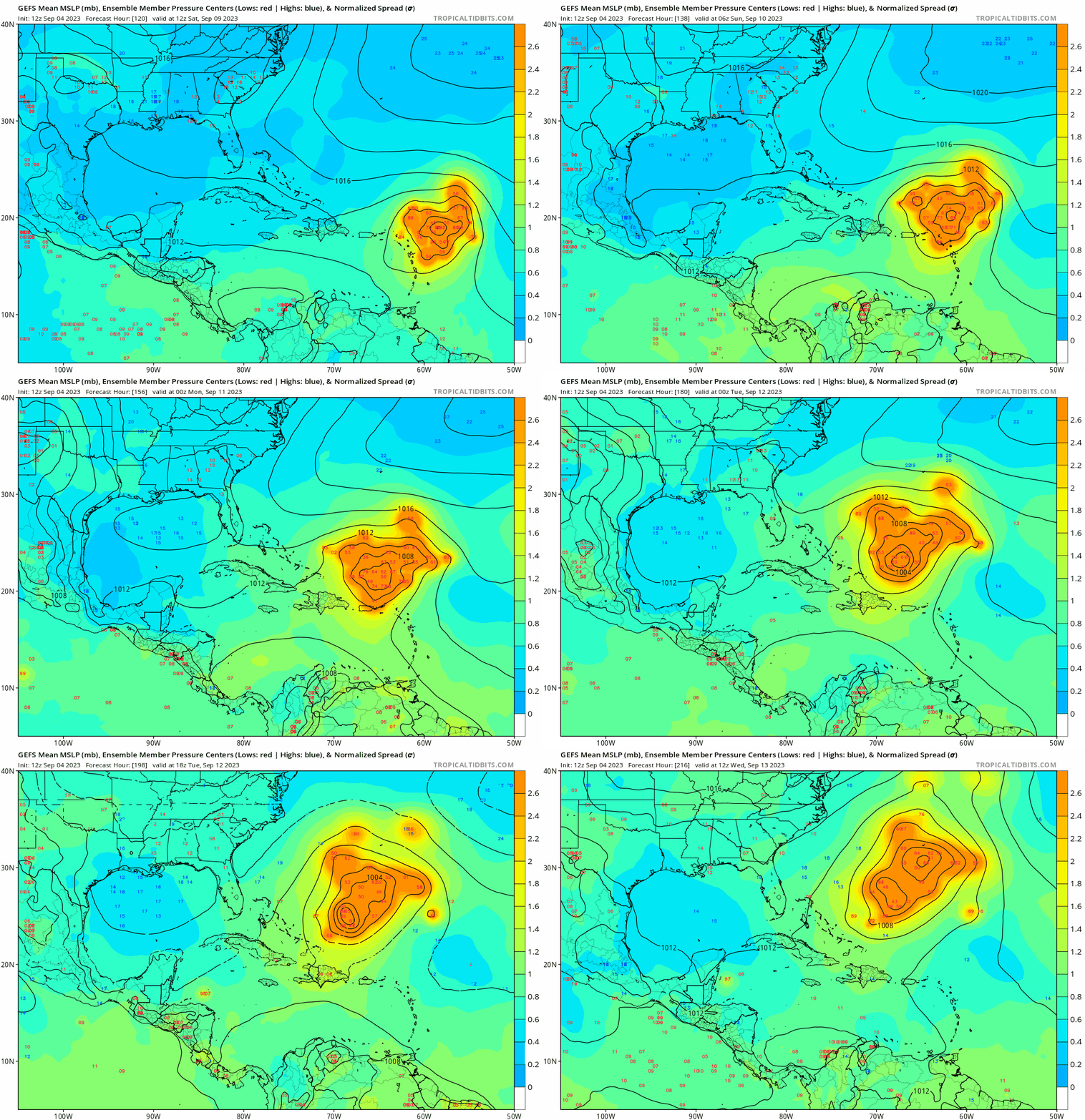
Bermuda under siege by the 12Z GFS ensembles. Fortunately still a ways out and things could change for them but a bit concerning since it looks like we might be talking about a powerful hurricane down the road and a pattern which could bring the storm in their general direction:

0 likes
-
TomballEd
- Category 5

- Posts: 1258
- Age: 62
- Joined: Wed Aug 16, 2023 4:52 pm
- Location: Spring/Klein area, not Tomball
Re: ATL: INVEST 95L - Models
Verbatim close call NE USA and then Nova Scotia. It looks like the GFS ensembles are again going to be generally E of the op. If anyone has access to the control run at 240 hours, I'd like to know if this a resolution caused difference.
0 likes
-
PavelGaborik10
- Category 1

- Posts: 472
- Joined: Tue Sep 04, 2018 3:23 pm
Re: ATL: INVEST 95L - Models
gatorcane wrote:The GFS seems to have a west-bias this year. We saw it for Franklin where it had it hitting Nova Scotia, we saw it with Idalia with it bringing into the FL panhandle, and possibly again with this storm.
The 12Z has shifted east and now is recurving east of the CONUS. While it is too early to say if the CONUS is in the clear, good to see the model shift east like that.
Now Bermuda on the other hand, looks a bit concerning looking at the overall model tracks.
12Z GFS loop from 114 hours:
https://i.postimg.cc/hj08M4D0/gfs-z500a-Norm-atl-fh120-264.gif
The Euro was actually the one who was more consistently bringing Franklin closer to Atlantic Canada in the long range.
GFS was essentially off the coast of Nova Scotia the entire time with the Icon. Euro blew that one.
1 likes
Re: ATL: INVEST 95L - Models
Today’s 12z HAFS-B run is the strongest model run for 95L so far. It peaks at the very end as a 145 kt/918 mbar Cat 5, thankfully north of the islands.
1 likes
Irene '11 Sandy '12 Hermine '16 5/15/2018 Derecho Fay '20 Isaias '20 Elsa '21 Henri '21 Ida '21
I am only a meteorology enthusiast who knows a decent amount about tropical cyclones. Look to the professional mets, the NHC, or your local weather office for the best information.
I am only a meteorology enthusiast who knows a decent amount about tropical cyclones. Look to the professional mets, the NHC, or your local weather office for the best information.
Who is online
Users browsing this forum: No registered users and 4 guests


