2023 Global Model Runs Discussion (Out thru day 16)
Moderator: S2k Moderators
Forum rules

The posts in this forum are NOT official forecasts and should not be used as such. They are just the opinion of the poster and may or may not be backed by sound meteorological data. They are NOT endorsed by any professional institution or STORM2K. For official information, please refer to products from the National Hurricane Center and National Weather Service.
-
emeraldislenc
- Category 2

- Posts: 602
- Joined: Fri Aug 24, 2012 4:49 pm
- Location: Emerald Isle NC
Re: 2023 Global Model Runs Discussion (Out thru day 16)
I think before the satellite era lots of hurricanes came off of Africa after Sept 4 or 5. The great Miami hurricane was first noticed on the 17th of Sept in the Lesser Antilles no doubt it probably came off of Africa I think that was in 1926. I think it is not wise to stay after Sept 5 no Cape Verde Storms never made it to Conus. Before satellites I am confident many storms came off Africa after early Sept.
8 likes
-
AnnularCane

- S2K Supporter

- Posts: 2964
- Joined: Thu Jun 08, 2006 9:18 am
- Location: Wytheville, VA
Re: 2023 Global Model Runs Discussion (Out thru day 16)
emeraldislenc wrote:I think before the satellite era lots of hurricanes came off of Africa after Sept 4 or 5. The great Miami hurricane was first noticed on the 17th of Sept in the Lesser Antilles no doubt it probably came off of Africa I think that was in 1926. I think it is not wise to stay after Sept 5 no Cape Verde Storms never made it to Conus. Before satellites I am confident many storms came off Africa after early Sept.
Not to mention Georges and Hugo.
2 likes
"But it never rained rain. It never snowed snow. And it never blew just wind. It rained things like soup and juice. It snowed mashed potatoes and green peas. And sometimes the wind blew in storms of hamburgers." -- Judi Barrett, Cloudy with a Chance of Meatballs
-
crownweather

- S2K Supporter
- Posts: 602
- Age: 51
- Joined: Sat Aug 12, 2006 9:21 am
- Location: Sturbridge, Massachusetts
- Contact:
Re: 2023 Global Model Runs Discussion (Out thru day 16)
AnnularCane wrote:emeraldislenc wrote:I think before the satellite era lots of hurricanes came off of Africa after Sept 4 or 5. The great Miami hurricane was first noticed on the 17th of Sept in the Lesser Antilles no doubt it probably came off of Africa I think that was in 1926. I think it is not wise to stay after Sept 5 no Cape Verde Storms never made it to Conus. Before satellites I am confident many storms came off Africa after early Sept.
Not to mention Georges and Hugo.
Also Gloria (1985) was a classic CV hurricane that almost reached Cat 5 strength at one point. Moved off of Africa around September 16.
2 likes
Rob Lightbown
Crown Weather Services
https://crownweather.com
Crown Weather Services
https://crownweather.com
Re: 2023 Global Model Runs Discussion (Out thru day 16)
A wave will exit Africa in day 7-8 range, and reaches 40W in day ~11. Some EPS members are on board, and overall condition looks favorable.
3 likes
Re: 2023 Global Model Runs Discussion (Out thru day 16)
zzzh wrote:A wave will exit Africa in day 7-8 range, and reaches 40W in day ~11. Some EPS members are on board, and overall condition looks favorable.
Not sure if this is the same wave but there’s a wave in the 18z GFS exits Africa Monday the 11th and goes across the Atlantic barely anything then reaches north of PR around September 17th then picks up steam and gets to 944mb at towards the end of the run heading WNW
3 likes
-
CFLHurricane

- Category 1

- Posts: 350
- Joined: Thu Mar 27, 2014 5:56 pm
- Location: Floriduh
Re: 2023 Global Model Runs Discussion (Out thru day 16)
LAF92 wrote:zzzh wrote:A wave will exit Africa in day 7-8 range, and reaches 40W in day ~11. Some EPS members are on board, and overall condition looks favorable.
Not sure if this is the same wave but there’s a wave in the 18z GFS exits Africa Monday the 11th and goes across the Atlantic barely anything then reaches north of PR around September 17th then picks up steam and gets to 944mb at towards the end of the run heading WNW
Not just heading WNW, but also in prime position to get trapped under a building high from the Midwest. It would be a truly cruel trick after sparing the Southeast from Lee.
1 likes
I'm not a meteorologist, but I did stay at a motel 8.
Re: 2023 Global Model Runs Discussion (Out thru day 16)
crownweather wrote:AnnularCane wrote:emeraldislenc wrote:I think before the satellite era lots of hurricanes came off of Africa after Sept 4 or 5. The great Miami hurricane was first noticed on the 17th of Sept in the Lesser Antilles no doubt it probably came off of Africa I think that was in 1926. I think it is not wise to stay after Sept 5 no Cape Verde Storms never made it to Conus. Before satellites I am confident many storms came off Africa after early Sept.
Not to mention Georges and Hugo.
Also Gloria (1985) was a classic CV hurricane that almost reached Cat 5 strength at one point. Moved off of Africa around September 16.
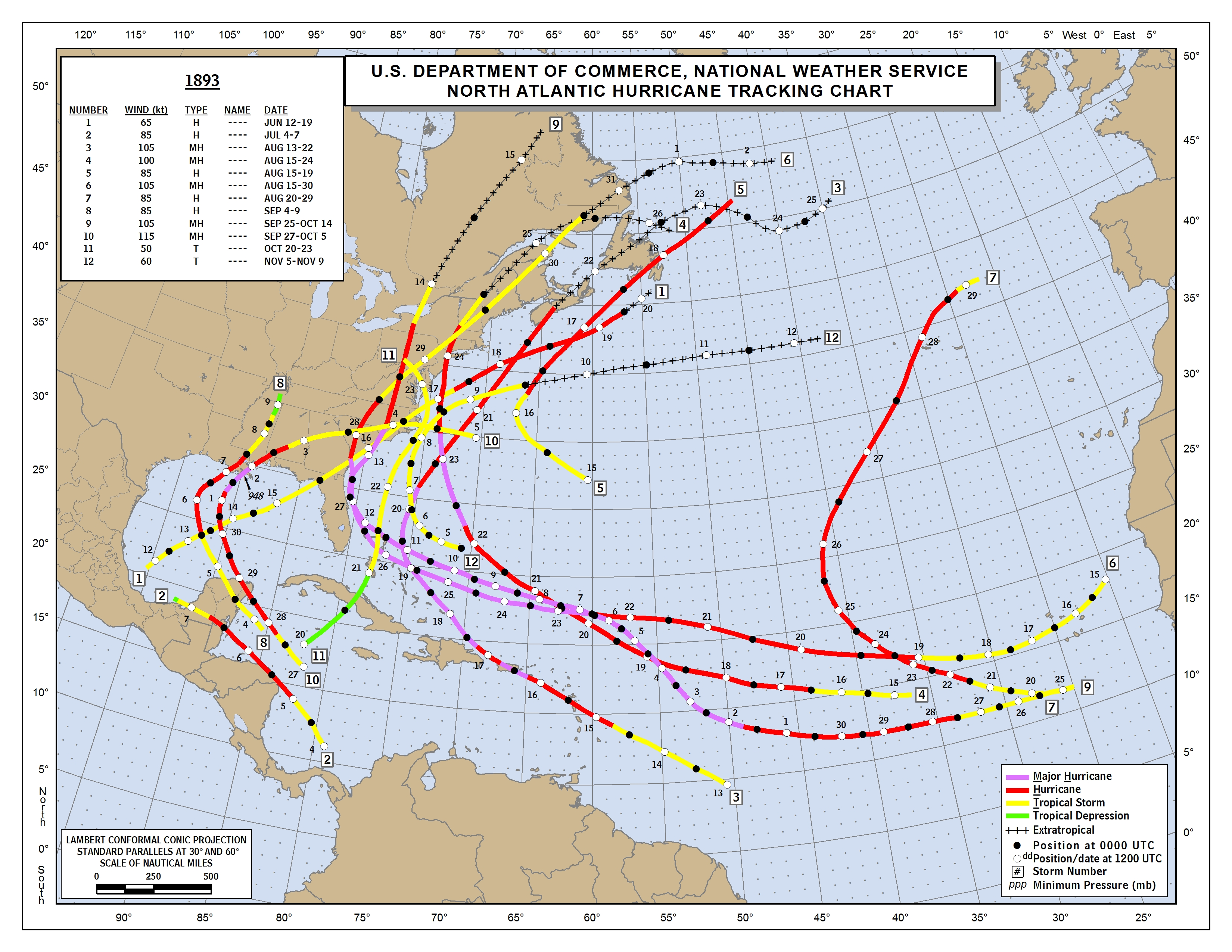
In 1893, storm #9 formed S of the CVs on Sept 25th and hit the Carolinas on Oct 13th as a MH. Sep 25th is the latest on record for an E MDR TC to form that later hit the CONUS:
https://www.nhc.noaa.gov/data/tracks/tracks-at-1893.png
0 likes
Personal Forecast Disclaimer:
The posts in this forum are NOT official forecasts and should not be used as such. They are just the opinion of the poster and may or may not be backed by sound meteorological data. They are NOT endorsed by any professional institution or storm2k.org. For official information, please refer to the NHC and NWS products.
The posts in this forum are NOT official forecasts and should not be used as such. They are just the opinion of the poster and may or may not be backed by sound meteorological data. They are NOT endorsed by any professional institution or storm2k.org. For official information, please refer to the NHC and NWS products.
-
emeraldislenc
- Category 2
- Posts: 602
- Joined: Fri Aug 24, 2012 4:49 pm
- Location: Emerald Isle NC
Re: 2023 Global Model Runs Discussion (Out thru day 16)
It would be interesting to find where the early stages of Hurricane Hazel formed which hit on the NC/SC border on Oct.15th.
1 likes
-
emeraldislenc
- Category 2
- Posts: 602
- Joined: Fri Aug 24, 2012 4:49 pm
- Location: Emerald Isle NC
Re: 2023 Global Model Runs Discussion (Out thru day 16)
I know Hazel approached the Antilles as a wave on Oct. 5, but this was before satellites and hurricane hunters were sent out on the 6 or 7 to investigate the wave.
0 likes

Re: 2023 Global Model Runs Discussion (Out thru day 16)
zzzh wrote:A wave will exit Africa in day 7-8 range, and reaches 40W in day ~11. Some EPS members are on board, and overall condition looks favorable.
0z GFS shows this wave becoming a Lee redux, peaking at 935 mb and on a similar trajectory as Lee.
CMC has also been showing this wave becoming a hurricane the past few runs.
1 likes
TC naming lists: retirements and intensity
Most aggressive Advisory #1's in North Atlantic (cr. kevin for starting the list)
Most aggressive Advisory #1's in North Atlantic (cr. kevin for starting the list)

Re: 2023 Global Model Runs Discussion (Out thru day 16)
Teban54 wrote:zzzh wrote:A wave will exit Africa in day 7-8 range, and reaches 40W in day ~11. Some EPS members are on board, and overall condition looks favorable.
0z GFS shows this wave becoming a Lee redux, peaking at 935 mb and on a similar trajectory as Lee.
CMC has also been showing this wave becoming a hurricane the past few runs.
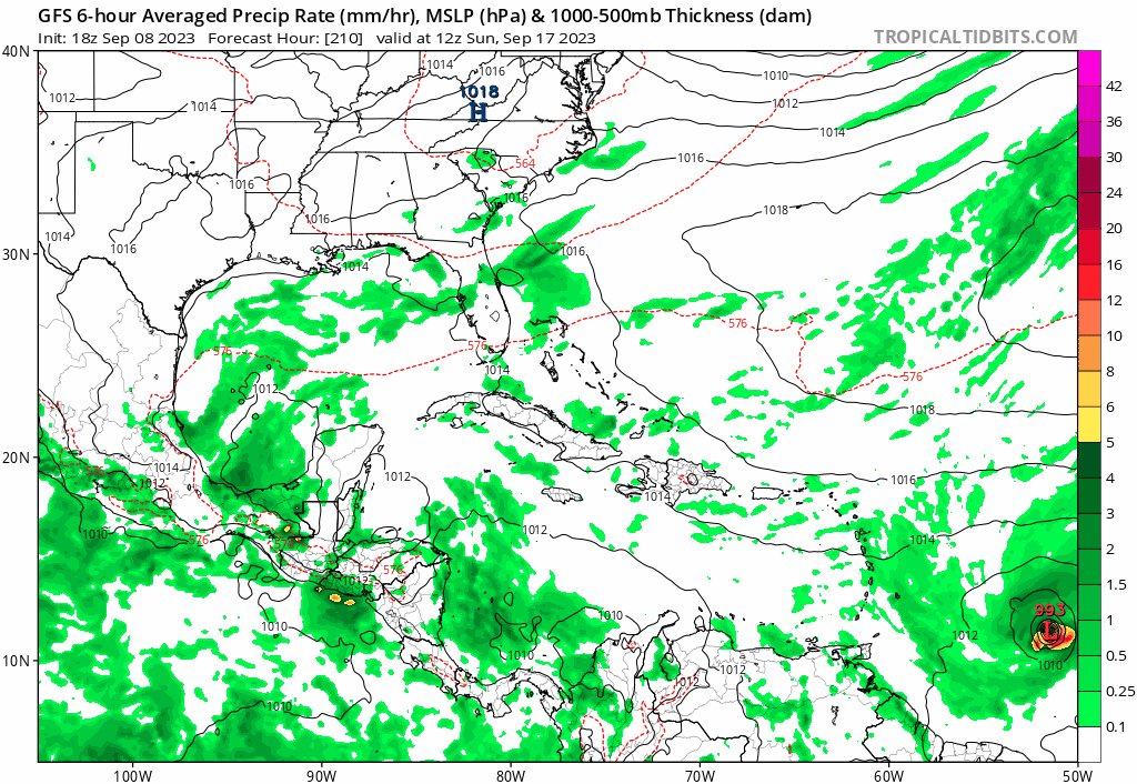
The Atlantic the last few weeks:
3 likes
-
AJC3

- Admin

- Posts: 4156
- Age: 62
- Joined: Tue Aug 31, 2004 7:04 pm
- Location: Ballston Spa, New York
- Contact:
Re: 2023 Global Model Runs Discussion (Out thru day 16)
FYI...
wxman57 wrote:Came across a very good tropical models page from a Univ. of OK PHD student. Has a multi-model ensemble plot of Lee using the GFS, EC, CMC, and UKMET ensembles. Lots of other stuff, too.
Select "Cumulative Plots", "Total Density (no lines)" for the graphic that shows the probability of the center passing within 150km of a point using all 4 ensembles.
http://arctic.som.ou.edu/tburg/products/realtime/tropical/ensembles.php?storm=AL132023
3 likes
Re: 2023 Global Model Runs Discussion (Out thru day 16)
Good thread (before and after this tweet) on the possible development of the next AEW after Margot.
https://twitter.com/dmorris9661/status/1699967784308887623
https://twitter.com/dmorris9661/status/1699967784308887623
1 likes
TC naming lists: retirements and intensity
Most aggressive Advisory #1's in North Atlantic (cr. kevin for starting the list)
Most aggressive Advisory #1's in North Atlantic (cr. kevin for starting the list)
-
ElectricStorm

- Category 5

- Posts: 5155
- Age: 25
- Joined: Tue Aug 13, 2019 11:23 pm
- Location: Norman, OK
Re: 2023 Global Model Runs Discussion (Out thru day 16)
12z CMC has a hurricane affecting the islands from a wave behind Margot. GFS is trying to get it going as well. Needs to be watched
2 likes
B.S Meteorology, University of Oklahoma '25
Please refer to the NHC, NWS, or SPC for official information.
Please refer to the NHC, NWS, or SPC for official information.
-
jlauderdal
- S2K Supporter
- Posts: 7240
- Joined: Wed May 19, 2004 5:46 am
- Location: NE Fort Lauderdale
- Contact:
Re: RE: Re: 2023 Global Model Runs Discussion (Out thru day 16)
Bear watch in effectElectricStorm wrote:12z CMC has a hurricane affecting the islands from a wave behind Margot. GFS is trying to get it going as well. Needs to be watched
1 likes
-
Cachondo23
- Tropical Storm

- Posts: 131
- Joined: Wed May 25, 2022 5:56 am
Re: 2023 Global Model Runs Discussion (Out thru day 16)
ElectricStorm wrote:12z CMC has a hurricane affecting the islands from a wave behind Margot. GFS is trying to get it going as well. Needs to be watched
Future Nigel? We’re entering the typical week the NE Caribbean get’s something in its area. Any thoughts of how strong will the High Pressure be? Interesting and difficult scenario to forecast giving that Lee and Margot will be out there for a while.
1 likes
-
ElectricStorm
- Category 5
- Posts: 5155
- Age: 25
- Joined: Tue Aug 13, 2019 11:23 pm
- Location: Norman, OK
Re: 2023 Global Model Runs Discussion (Out thru day 16)
18z GFS has two MDR systems in the mid-long range, one enters the Caribbean as a hurricane and the other is a quick recurve strong TS/Cat 1 just west of Cabo Verde
1 likes
B.S Meteorology, University of Oklahoma '25
Please refer to the NHC, NWS, or SPC for official information.
Please refer to the NHC, NWS, or SPC for official information.


Re: 2023 Global Model Runs Discussion (Out thru day 16)
ElectricStorm wrote:18z GFS has two MDR systems in the mid-long range, one enters the Caribbean as a hurricane and the other is a quick recurve strong TS/Cat 1 just west of Cabo Verde
One that enters the Caribbean grows to a monster and ends up going up into the Eastern Gulf.
By wary if the GFS does as good as the current system.
1 likes
Re: 2023 Global Model Runs Discussion (Out thru day 16)
MetroMike wrote:ElectricStorm wrote:18z GFS has two MDR systems in the mid-long range, one enters the Caribbean as a hurricane and the other is a quick recurve strong TS/Cat 1 just west of Cabo Verde
One that enters the Caribbean grows to a monster and ends up going up into the Eastern Gulf.
By wary if the GFS does as good as the current system.
Yea, end of run looks like another major in the eastern gulf. Run ends near keywest. But looks like a terrible path for Tampa on South as a major.
2 likes
-
Blown Away

- S2K Supporter
- Posts: 10253
- Joined: Wed May 26, 2004 6:17 am
Re: 2023 Global Model Runs Discussion (Out thru day 16)
18z GFS… Goes over Hispaniola & Cuba and maintains MH into KW and EGOM…
Last edited by Blown Away on Fri Sep 08, 2023 7:01 pm, edited 1 time in total.
2 likes
Hurricane Eye Experience: David 79, Irene 99, Frances 04, Jeanne 04, Wilma 05… Hurricane Brush Experience: Andrew 92, Erin 95, Floyd 99, Matthew 16, Irma 17, Ian 22, Nicole 22…
Who is online
Users browsing this forum: No registered users and 124 guests