
Models will do better when they have a closed low to initialize with.
ASCAT last night shows it was still attached to the ITCZ but with this mornings convection it will probably close off closer to -45 than -50. SSTs are warmer in September so potentially good news for the islands that its not spinning up late. Haven't seen any ridge trapping model runs with tracks that threaten the ConUS yet.
ATL: LEE - Post-Tropical - Discussion
Moderator: S2k Moderators
Re: ATL: INVEST 95L - Discussion
2 likes

Re: ATL: INVEST 95L - Discussion
Nimbus wrote:Models will do better when they have a closed low to initialize with.
ASCAT last night shows it was still attached to the ITCZ but with this mornings convection it will probably close off closer to -45 than -50. SSTs are warmer in September so potentially good news for the islands that its not spinning up late. Haven't seen any ridge trapping model runs with tracks that threaten the ConUS yet.
Glad to hear that Long Island and New England have been excluded from CONUS
7 likes
TC naming lists: retirements and intensity
Most aggressive Advisory #1's in North Atlantic (cr. kevin for starting the list)
Most aggressive Advisory #1's in North Atlantic (cr. kevin for starting the list)

Re: ATL: INVEST 95L - Discussion
Excerpt from 8 AM Tropical Weather Update:
Subtle change in wording (i.e., the word possibly has been omitted).
Central Tropical Atlantic (AL95):
Satellite images indicate that the area of low pressure located
about midway between western Africa and the Windward Islands has
become better organized overnight. If current trends continue,
advisories would be issued later today on a tropical cyclone moving
west-northwest at 15 to 20 mph across the central tropical
Atlantic. Additional strengthening to a hurricane is likely later
this week while the system moves over western portions of the
tropical Atlantic, near or to the northeast of the northern Leeward
Islands. For additional information on this system, including gale
warnings, see High Seas Forecasts issued by the National Weather
Service.
* Formation chance through 48 hours...high...near 100 percent.
* Formation chance through 7 days...high...near 100 percent.
Subtle change in wording (i.e., the word possibly has been omitted).
3 likes
-
Blown Away

- S2K Supporter

- Posts: 10253
- Joined: Wed May 26, 2004 6:17 am
Re: ATL: INVEST 95L - Discussion
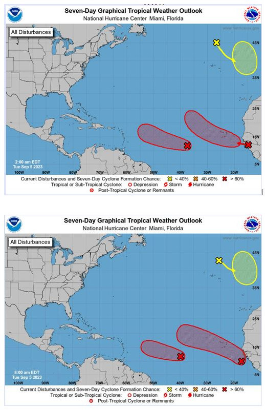
NHC cone changes from 2am to 8am... There appears to be a pattern change...
1 likes
Hurricane Eye Experience: David 79, Irene 99, Frances 04, Jeanne 04, Wilma 05… Hurricane Brush Experience: Andrew 92, Erin 95, Floyd 99, Matthew 16, Irma 17, Ian 22, Nicole 22…
-
SecondBreakfast
- Tropical Storm

- Posts: 102
- Joined: Sun Sep 10, 2017 7:14 am
- Location: NYC/LI
Re: ATL: INVEST 95L - Discussion
“Sandy 2.0” is getting hyped to the moon on social media and I don’t like it one bit.
0 likes
Biologist by training, weather enthusiast for life.
Re: ATL: INVEST 95L - Discussion
Blown Away wrote:[url]https://i.postimg.cc/Pfbng41f/NHC-8am.jpg [/url]
NHC cone changes from 2am to 8am... There appears to be a pattern change...
After closely examining those images I think it's just that AL95 is now expected to become a tropical cyclone earlier than previously thought.
0 likes
-
cheezyWXguy

- Category 5

- Posts: 6281
- Joined: Mon Feb 13, 2006 12:29 am
- Location: Dallas, TX
Re: ATL: INVEST 95L - Discussion
Looks like a td to me now, that circulation appears a good deal more consolidated than last night.
1 likes

Re: ATL: INVEST 95L - Discussion
Agreed with the TD, I think NHC will pull the trigger at 11am.
1 likes
-
Blown Away
- S2K Supporter
- Posts: 10253
- Joined: Wed May 26, 2004 6:17 am
Re: ATL: INVEST 95L - Discussion
95L is flying and appears COC is farther N @12.6N/40.5W...
0 likes
Hurricane Eye Experience: David 79, Irene 99, Frances 04, Jeanne 04, Wilma 05… Hurricane Brush Experience: Andrew 92, Erin 95, Floyd 99, Matthew 16, Irma 17, Ian 22, Nicole 22…
Re: ATL: INVEST 95L - Discussion
Have any of you ever seen a TWO where the NHC was so confident an invest would become a hurricane? I can't recall any.
2 likes

Re: ATL: INVEST 95L - Discussion
abajan wrote:Have any of you ever seen a TWO where the NHC was so confident an invest would become a hurricane? I can't recall any.
I was thinking the same thing; Pretty bullish indeed!
1 likes
Andy D
(For official information, please refer to the NHC and NWS products.)
(For official information, please refer to the NHC and NWS products.)
Re: ATL: INVEST 95L - Discussion
I noticed an area north of Hispaniola and Puerto Rico this morning on satellite, I don't think it's tagged by the NHC tho....just curious wassup...(sorry for off-topic question)
Last edited by underthwx on Tue Sep 05, 2023 8:23 am, edited 1 time in total.
0 likes
-
cycloneye

- Admin

- Posts: 149278
- Age: 69
- Joined: Thu Oct 10, 2002 10:54 am
- Location: San Juan, Puerto Rico
Re: ATL: INVEST 95L - Discussion
AL, 95, 2023090512, , BEST, 0, 122N, 396W, 30, 1008, LO

0 likes
Visit the Caribbean-Central America Weather Thread where you can find at first post web cams,radars
and observations from Caribbean basin members Click Here
and observations from Caribbean basin members Click Here
-
WalterWhite

- Category 1

- Posts: 342
- Joined: Fri Mar 17, 2023 5:53 pm
Re: ATL: INVEST 95L - Discussion
cycloneye wrote:AL, 95, 2023090512, , BEST, 0, 122N, 396W, 30, 1008, LO
https://i.imgur.com/hnw6HkX.png
It seems to have moved a fair bit north. Hopefully this continues.
2 likes
-
Tireman4

- S2K Supporter
- Posts: 5903
- Age: 60
- Joined: Fri Jun 30, 2006 1:08 pm
- Location: Humble, Texas
- Contact:
Re: ATL: INVEST 95L - Discussion
chaser1 wrote:abajan wrote:Have any of you ever seen a TWO where the NHC was so confident an invest would become a hurricane? I can't recall any.
I was thinking the same thing; Pretty bullish indeed!
This one will be interesting. Very interesting.
1 likes

Re: ATL: INVEST 95L - Discussion
abajan wrote:Have any of you ever seen a TWO where the NHC was so confident an invest would become a hurricane? I can't recall any.
The 100% is very unusual. Maybe they should have said 97.3%. I think the only other time I have seen that is when they were already preparing advisories for the upcoming package time, three hours later.
0 likes
List of 79 tropical cyclones intercepted by Richard Horodner:
http://www.canebeard.com/page/page/572246.htm
former storm2k screenname Beoumont 2009+
http://www.canebeard.com/page/page/572246.htm
former storm2k screenname Beoumont 2009+

Re: ATL: INVEST 95L - Discussion
cycloneye wrote:AL, 95, 2023090512, , BEST, 0, 122N, 396W, 30, 1008, LO
https://i.imgur.com/hnw6HkX.png
Very happy to see this!
1 likes

Re: ATL: INVEST 95L - Discussion
At the start of the season, Lee was one of the names I pegged to be one of the “baddies” of the year (either in intensity or impact). Looks like it could be trending that way. Expecting advisories in an hour.
3 likes
-
WalterWhite
- Category 1
- Posts: 342
- Joined: Fri Mar 17, 2023 5:53 pm
Re: ATL: INVEST 95L - Discussion
zzzh wrote:AL132023 - Tropical Depression THIRTEEN
According to whom? This system is still listed as Invest 95L on the best track database.
0 likes
Who is online
Users browsing this forum: No registered users and 26 guests