ATL: LEE - Post-Tropical - Discussion

Moderator: S2k Moderators

Message
Author
User avatar
WalterWhite
Category 1
Category 1
Posts: 342
Joined: Fri Mar 17, 2023 5:53 pm

Re: ATL: THIRTEEN - Tropical Depression - Discussion

#281 Postby WalterWhite » Tue Sep 05, 2023 10:01 am

Wait...did they copy+paste the last Franklin advisory for this?

000
WTNT43 KNHC 012040
TCDAT3

Post-Tropical Cyclone Franklin Discussion Number 49
NWS National Hurricane Center Miami FL AL082023
500 PM AST Fri Sep 01 2023

The satellite appearance of Franklin suggests the cyclone has
undergone a warm core seclusion process. Earlier scatterometer data
showed a cold front nearing the core of Franklin, and recent visible
satellite images suggest the presence of a bent-back occlusion
wrapping around the western side of the low that appears to be the
focus for the ongoing convection. Also, the latest FSU phase space
diagrams from the GFS and ECMWF models show a thickness asymmetry
consistent with a warm-core frontal cyclone. Therefore, it appears
Franklin has completed its extratropical transition and is no longer
a tropical cyclone. Since the earlier scatterometer data, the latest
global model fields suggest that baroclinic forcing has resulted in
a deepening of the low, with an acceleration of northerly winds to
the west of the bent-back front. A blend of wind speeds from the
various global models supports an initial intensity of 70 kt.

Franklin appears likely to remain a powerful, hurricane-force
extratropical cyclone during the next 12 h or so due to baroclinic
forcing. Thereafter, the extratropical cyclone is forecast to weaken
as the low moves deeper into the mid-latitudes and gradually fills.
Franklin is still moving northeastward (50/15 kt) within the flow
between a deep-layer trough over the northwestern Atlantic and a
subtropical ridge over the central Atlantic. A faster northeastward
motion is forecast during the next couple of days, followed by a
gradual turn toward the east and east-southeast later in the
period as the cyclone rotates around a larger cut-off low over the
eastern Atlantic. The global models are finally in better agreement
on this outcome, and the track forecast has been adjusted south of
the previous one at days 3-5.

This is the last advisory issued by the National Hurricane Center on
Franklin. Additional information on this system can be found in High
Seas Forecasts issued by the National Weather Service, under AWIPS
header NFDHSFAT1, WMO header FZNT01 KWBC, and online at
ocean.weather.gov/shtml/NFDHSFAT1.php


FORECAST POSITIONS AND MAX WINDS

INIT 01/2100Z 39.5N 53.8W 70 KT 80 MPH...POST-TROPICAL
12H 02/0600Z 41.1N 50.2W 70 KT 80 MPH...POST-TROP/EXTRATROP
24H 02/1800Z 43.6N 45.6W 60 KT 70 MPH...POST-TROP/EXTRATROP
36H 03/0600Z 45.5N 41.4W 50 KT 60 MPH...POST-TROP/EXTRATROP
48H 03/1800Z 46.8N 36.7W 45 KT 50 MPH...POST-TROP/EXTRATROP
60H 04/0600Z 47.8N 32.4W 40 KT 45 MPH...POST-TROP/EXTRATROP
72H 04/1800Z 48.0N 29.5W 35 KT 40 MPH...POST-TROP/EXTRATROP
96H 05/1800Z 47.5N 26.0W 35 KT 40 MPH...POST-TROP/EXTRATROP
120H 06/1800Z 46.0N 20.5W 35 KT 40 MPH...POST-TROP/EXTRATROP

$$
Forecaster Reinhart
0 likes   

User avatar
aspen
Category 5
Category 5
Posts: 8818
Joined: Sat Oct 12, 2019 7:10 pm
Location: Connecticut, USA

Re: ATL: THIRTEEN - Tropical Depression - Discussion

#282 Postby aspen » Tue Sep 05, 2023 10:01 am

120 kt first advisory peak. Holy cow :double:
5 likes   
Irene '11 Sandy '12 Hermine '16 5/15/2018 Derecho Fay '20 Isaias '20 Elsa '21 Henri '21 Ida '21

I am only a meteorology enthusiast who knows a decent amount about tropical cyclones. Look to the professional mets, the NHC, or your local weather office for the best information.

User avatar
kevin
Category 5
Category 5
Posts: 2586
Age: 26
Joined: Wed Aug 28, 2019 4:35 am

Re: ATL: THIRTEEN - Tropical Depression - Discussion

#283 Postby kevin » Tue Sep 05, 2023 10:01 am

First advisory is here, 120 kt :double:
Note: the highest 1st advisory since 1998 (when the advisory archive started) was 100 kt... What is happening.

382
WTNT43 KNHC 051459
TCDAT3

Tropical Depression Thirteen Discussion Number 1
NWS National Hurricane Center Miami FL AL132023
1100 AM AST Tue Sep 05 2023

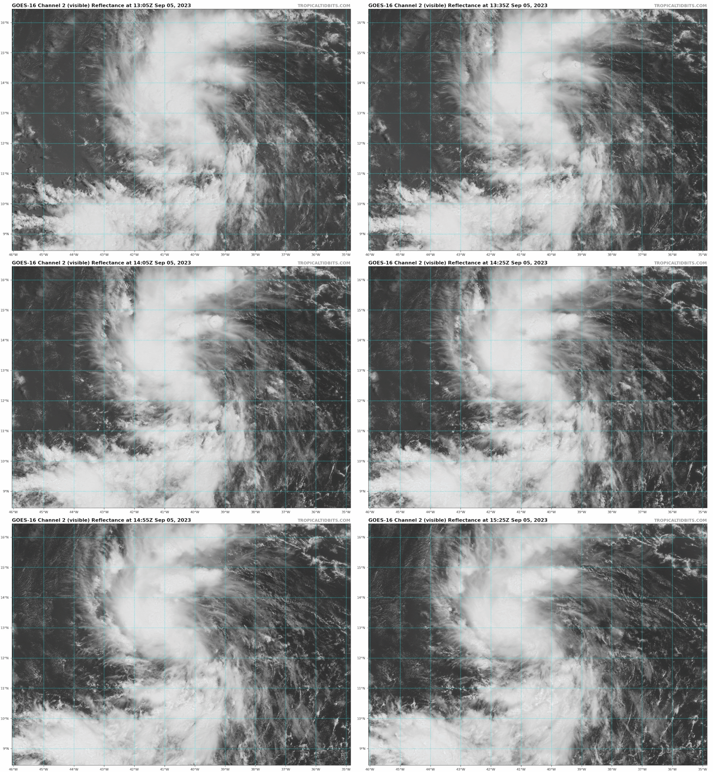
Satellite images indicate that the tropical wave (Invest AL95) that
we have been following for several days has become better organized
this morning, with many curved low-level banding features. A
partial scatterometer pass near 1201 UTC indicated a well-defined
center had formed, with winds speeds of about 30 kt. Thus,
advisories have been initiated on Tropical Depression Thirteen, and
the current intensity is set to 30 kt.

The depression is moving west-northwestward at about 13 kt. A
mid-level ridge over the central Atlantic is expected to persist to
the north of the tropical cyclone, keeping the system moving with
this general motion through Saturday. The spread in the model
guidance is remarkably low for a first advisory, and the official
forecast is near or west of the model consensus. However, it
should be noted that the NOAA corrected-consensus aids and some
ensemble members are still to the left of the official forecast, so
it is too early to determine exactly how close this system will get
to the Leeward Islands given the average track forecast error at
those time ranges.

The environment around the depression appears to be conducive for
strengthening. The only obvious hindering factor is
light-to-moderate northeasterly shear, which should keep the
intensification rate in check in the short term. However, in two to
three days, this shear is forecast to relax with an upper-level
ridge building near the cyclone, and the system should be moving
over record-warm waters of near 30 deg C east of the Lesser Antilles
(that would look more in place in the Gulf of Mexico). These
factors could support rapid intensification by the end of the week,
although it too early to determine exactly when this might occur
until a better-defined inner core forms. The NHC intensity forecast
is extremely bullish for a first forecast, but remarkably lies
below the intensity consensus. All indications are that the
depression will become a strong hurricane by the end of the forecast
period.

KEY MESSAGES:

1. The depression is forecast to become a major hurricane by
this weekend and could bring impacts to the Leeward Islands by that
time. While it is too soon to determine the location and magnitude
of these possible impacts, interests in this area should monitor
the progress of the depression and updates to the forecast.

FORECAST POSITIONS AND MAX WINDS

INIT 05/1500Z 12.5N 40.2W 30 KT 35 MPH
12H 06/0000Z 12.8N 42.1W 40 KT 45 MPH
24H 06/1200Z 13.6N 44.7W 50 KT 60 MPH
36H 07/0000Z 14.4N 47.2W 60 KT 70 MPH
48H 07/1200Z 15.3N 49.7W 70 KT 80 MPH
60H 08/0000Z 16.2N 52.2W 80 KT 90 MPH
72H 08/1200Z 17.3N 54.7W 95 KT 110 MPH
96H 09/1200Z 19.4N 59.1W 115 KT 130 MPH
120H 10/1200Z 21.5N 63.5W 120 KT 140 MPH

$$
Forecaster Blake
4 likes   

User avatar
WalterWhite
Category 1
Category 1
Posts: 342
Joined: Fri Mar 17, 2023 5:53 pm

Re: ATL: THIRTEEN - Tropical Depression - Discussion

#284 Postby WalterWhite » Tue Sep 05, 2023 10:01 am

Okay, it is fixed, but 120 knots for the initial forecast. YIKES!
5 likes   

User avatar
kevin
Category 5
Category 5
Posts: 2586
Age: 26
Joined: Wed Aug 28, 2019 4:35 am

Re: ATL: THIRTEEN - Tropical Depression - Discussion

#285 Postby kevin » Tue Sep 05, 2023 10:02 am

The NHC intensity forecast is extremely bullish for a first forecast, but remarkably lies below the intensity consensus.


And the forecast is already 120 kt :double:. If we're getting a cat 5 this season, this is it.
8 likes   

User avatar
WalterWhite
Category 1
Category 1
Posts: 342
Joined: Fri Mar 17, 2023 5:53 pm

Re: ATL: THIRTEEN - Tropical Depression - Discussion

#286 Postby WalterWhite » Tue Sep 05, 2023 10:03 am

kevin wrote:
The NHC intensity forecast is extremely bullish for a first forecast, but remarkably lies below the intensity consensus.


And the forecast is already 120 kt :double:. If we're getting a cat 5 this season, this is it.


Not even Hurricane Wilma had this bullish of a forecast.
7 likes   

User avatar
kevin
Category 5
Category 5
Posts: 2586
Age: 26
Joined: Wed Aug 28, 2019 4:35 am

Re: ATL: THIRTEEN - Tropical Depression - Discussion

#287 Postby kevin » Tue Sep 05, 2023 10:06 am

Image
2 likes   

User avatar
Iceresistance
Category 5
Category 5
Posts: 9288
Age: 21
Joined: Sat Oct 10, 2020 9:45 am
Location: Tecumseh, OK/Norman, OK

Re: ATL: THIRTEEN - Tropical Depression - Discussion

#288 Postby Iceresistance » Tue Sep 05, 2023 10:10 am

Saw someone on a different forum point out that this is the highest intensity forecast EVER from the NHC on the first advisory. Rick 2009 was 115 knots on his first advisory.
21 likes   
Bill 2015 & Beta 2020

Winter 2020-2021 :cold:

All observations are in Tecumseh, OK unless otherwise noted.

Winter posts are focused mainly for Oklahoma & Texas.

Take any of my forecasts with a grain of salt, refer to the NWS, SPC, and NHC for official information

Never say Never with weather! Because ANYTHING is possible!

psyclone
S2K Supporter
S2K Supporter
Posts: 4762
Joined: Wed Aug 24, 2005 9:04 pm
Location: palm harbor fl

Re: ATL: THIRTEEN - Tropical Depression - Discussion

#289 Postby psyclone » Tue Sep 05, 2023 10:13 am

Peak season crazy major long tracker on deck. Still feeling good about this not wrecking someone...but there's a reason a new track forecast comes out every 6 hours so we watch with an intensity on par with the storm.
6 likes   

User avatar
cycloneye
Admin
Admin
Posts: 145303
Age: 68
Joined: Thu Oct 10, 2002 10:54 am
Location: San Juan, Puerto Rico

Re: ATL: THIRTEEN - Tropical Depression - Discussion

#290 Postby cycloneye » Tue Sep 05, 2023 10:15 am

To our members in the Leeward Islands, please read this.

The depression is forecast to become a major hurricane by
this weekend and could bring impacts to the Leeward Islands by that
time. While it is too soon to determine the location and magnitude
of these possible impacts, interests in this area should monitor
the progress of the depression and updates to the forecast.
12 likes   
Visit the Caribbean-Central America Weather Thread where you can find at first post web cams,radars
and observations from Caribbean basin members Click Here

underthwx
Category 5
Category 5
Posts: 2360
Joined: Sat Jul 30, 2011 2:14 pm
Location: Brazoria County Texas

Re: ATL: THIRTEEN - Tropical Depression - Discussion

#291 Postby underthwx » Tue Sep 05, 2023 10:16 am

psyclone wrote:Peak season crazy major long tracker on deck. Still feeling good about this not wrecking someone...but there's a reason a new track forecast comes out every 6 hours so we watch with an intensity on par with the storm.

Any thoughts on track/intensity at the end of the NHC forecast period?....what feature is dominant in steering the depression?...The official track takes it north of the Lesser Antilles as a Category 4 hurricane?
Last edited by underthwx on Tue Sep 05, 2023 10:22 am, edited 3 times in total.
0 likes   

User avatar
cycloneye
Admin
Admin
Posts: 145303
Age: 68
Joined: Thu Oct 10, 2002 10:54 am
Location: San Juan, Puerto Rico

Re: ATL: THIRTEEN - Tropical Depression - Discussion

#292 Postby cycloneye » Tue Sep 05, 2023 10:16 am

psyclone wrote:Peak season crazy major long tracker on deck. Still feeling good about this not wrecking someone...but there's a reason a new track forecast comes out every 6 hours so we watch with an intensity on par with the storm.


Agree. From now on, any jog to the left or right will be very important.
9 likes   
Visit the Caribbean-Central America Weather Thread where you can find at first post web cams,radars
and observations from Caribbean basin members Click Here

User avatar
zal0phus
Tropical Storm
Tropical Storm
Posts: 192
Age: 24
Joined: Mon Jan 07, 2019 8:32 am
Location: St. Louis
Contact:

Re: ATL: THIRTEEN - Tropical Depression - Discussion

#293 Postby zal0phus » Tue Sep 05, 2023 10:38 am

What's the potential ceiling here? I at least feel like this has a solid potential to be the strongest hurricane in the open Atlantic, maybe in the top ten strongest in the entire Atlantic
0 likes   
Do not take anything I say seriously as a form of meteorological prediction. I am not a meteorologist; I don't think being in law school translates to any special knowledge. I am just a somewhat bullish amateur watcher.

User avatar
Blown Away
S2K Supporter
S2K Supporter
Posts: 10145
Joined: Wed May 26, 2004 6:17 am

Re: ATL: THIRTEEN - Tropical Depression - Discussion

#294 Postby Blown Away » Tue Sep 05, 2023 10:40 am

cycloneye wrote:
psyclone wrote:Peak season crazy major long tracker on deck. Still feeling good about this not wrecking someone...but there's a reason a new track forecast comes out every 6 hours so we watch with an intensity on par with the storm.


Agree. From now on, any jog to the left or right will be very important.

Image
IMO TD13 is moving near due W, I think the latitude adjustment was for the COC consolidating, not true WNW.
4 likes   
Hurricane Eye Experience: David 79, Irene 99, Frances 04, Jeanne 04, Wilma 05... EYE COMING MY WAY IN 2024…
Hurricane Brush Experience: Andrew 92, Erin 95, Floyd 99, Matthew 16, Irma 17, Ian 22, Nicole 22…

psyclone
S2K Supporter
S2K Supporter
Posts: 4762
Joined: Wed Aug 24, 2005 9:04 pm
Location: palm harbor fl

Re: ATL: THIRTEEN - Tropical Depression - Discussion

#295 Postby psyclone » Tue Sep 05, 2023 10:47 am

underthwx wrote:
psyclone wrote:Peak season crazy major long tracker on deck. Still feeling good about this not wrecking someone...but there's a reason a new track forecast comes out every 6 hours so we watch with an intensity on par with the storm.

Any thoughts on track/intensity at the end of the NHC forecast period?....what feature is dominant in steering the depression?...The official track takes it north of the Lesser Antilles as a Category 4 hurricane?


I'm not a met but based on the time of year, location, OHC, and expected upper level conditions...I'm thinking we have a super typhoon (high end cat 4+) on our hands with a decent shot of a cat 5. As for track I'd listen to the pros. I'm just an optimist sitting on the riverbank watching in awe as the corks float down the river. Let's hope Lee's impacts on land are limited to spectacular surf...but that story is yet to be written.
2 likes   

underthwx
Category 5
Category 5
Posts: 2360
Joined: Sat Jul 30, 2011 2:14 pm
Location: Brazoria County Texas

Re: ATL: THIRTEEN - Tropical Depression - Discussion

#296 Postby underthwx » Tue Sep 05, 2023 10:49 am

psyclone wrote:
underthwx wrote:
psyclone wrote:Peak season crazy major long tracker on deck. Still feeling good about this not wrecking someone...but there's a reason a new track forecast comes out every 6 hours so we watch with an intensity on par with the storm.

Any thoughts on track/intensity at the end of the NHC forecast period?....what feature is dominant in steering the depression?...The official track takes it north of the Lesser Antilles as a Category 4 hurricane?


I'm not a met but based on the time of year, location, OHC, and expected upper level conditions...I'm thinking we have a super typhoon (high end cat 4+) on our hands with a decent shot of a cat 5. As for track I'd listen to the pros. I'm just an optimist sitting on the riverbank watching in awe as the corks float down the river. Let's hope Lee's impacts on land are limited to spectacular surf...but that story is yet to be written.

Thankyou for your reply, this cyclone is worrisome to me...the first advisory from the NHC highlights the need to stay aware of this developing situation
2 likes   

User avatar
msbee
S2K Supporter
S2K Supporter
Posts: 3027
Joined: Wed Jun 11, 2003 10:11 am
Location: St. Maarten

Re: ATL: THIRTEEN - Tropical Depression - Discussion

#297 Postby msbee » Tue Sep 05, 2023 10:49 am

Thank you all for posting the official NHC forecasts. And your analyses.
Question….does NHC email these forecasts? I remember I used to be on a mailing list for them. Is this still available?
0 likes   
Too many hurricanes to remember

User avatar
blp
Category 5
Category 5
Posts: 2840
Age: 46
Joined: Thu Sep 09, 2004 7:51 pm
Location: Miami, FL
Contact:

Re: ATL: THIRTEEN - Tropical Depression - Discussion

#298 Postby blp » Tue Sep 05, 2023 10:52 am

Blown Away wrote:
cycloneye wrote:
psyclone wrote:Peak season crazy major long tracker on deck. Still feeling good about this not wrecking someone...but there's a reason a new track forecast comes out every 6 hours so we watch with an intensity on par with the storm.


Agree. From now on, any jog to the left or right will be very important.

[url]https://i.postimg.cc/90tc2HRB/a6c860c3-69b2-43ce-808b-7047b77d29f4.gif [/url]
IMO TD13 is moving near due W, I think the latitude adjustment was for the COC consolidating, not true WNW.


Agree. That is what I keep seeing.
0 likes   
The following post is NOT an official forecast and should not be used as such. It is just the opinion of the poster and may or may not be backed by sound meteorological data. It is NOT endorsed by any professional institution including storm2k.org For Official Information please refer to the NHC and NWS products.

underthwx
Category 5
Category 5
Posts: 2360
Joined: Sat Jul 30, 2011 2:14 pm
Location: Brazoria County Texas

Re: ATL: THIRTEEN - Tropical Depression - Discussion

#299 Postby underthwx » Tue Sep 05, 2023 10:58 am

msbee wrote:Thank you all for posting the official NHC forecasts. And your analyses.
Question….does NHC email these forecasts? I remember I used to be on a mailing list for them. Is this still available?


I found this, I hope it works for you, I read they discontinued this service, but then I found this......Automatic alerts are available directly from NHC when a new tropical cyclone advisory is issued by following NHC on Twitter: @NHC_Atlantic and @NHC_Pacific.
0 likes   

hohnywx
Category 2
Category 2
Posts: 508
Age: 34
Joined: Sun Jul 19, 2009 8:34 pm
Location: Hastings-on-Hudson, NY

Re: ATL: THIRTEEN - Tropical Depression - Discussion

#300 Postby hohnywx » Tue Sep 05, 2023 10:59 am

msbee wrote:Thank you all for posting the official NHC forecasts. And your analyses.
Question….does NHC email these forecasts? I remember I used to be on a mailing list for them. Is this still available?


They discontinued that service years ago unfortunately. Never understood why as it was a valuable tool!
0 likes   


Return to “2023”

Who is online

Users browsing this forum: No registered users and 2 guests