ATL: LEE - Models

Moderator: S2k Moderators

Message
Author
AxaltaRacing24
Category 5
Category 5
Posts: 1753
Age: 25
Joined: Wed Jul 27, 2016 11:14 am
Location: Jupiter, FL

Re: ATL: LEE - Models

#381 Postby AxaltaRacing24 » Tue Sep 05, 2023 6:44 pm


Most still miss, but there is clearly a new camp here that shows Lee missing the initial weakness. It's important to focus on the trend instead of the exact tracks depicted here.
3 likes   

User avatar
Owasso
Category 1
Category 1
Posts: 309
Joined: Sat Aug 22, 2020 11:14 pm
Location: Chicago, Illinois

Re: ATL: LEE - Models

#382 Postby Owasso » Tue Sep 05, 2023 6:44 pm

Image

If this verified :double:
6 likes   

Ianswfl
Category 1
Category 1
Posts: 482
Joined: Thu Mar 23, 2023 11:11 pm

Re: ATL: LEE - Models

#383 Postby Ianswfl » Tue Sep 05, 2023 6:53 pm

AxaltaRacing24 wrote:

Most still miss, but there is clearly a new camp here that shows Lee missing the initial weakness. It's important to focus on the trend instead of the exact tracks depicted here.


One of those members is bringing a 949mb hurricane same track as Matthew then towards the GA coast. Note it also has cat3 super low rider coming into the Carribean. Ivan like??
0 likes   

User avatar
TheDreamTraveler
Category 2
Category 2
Posts: 641
Joined: Sun Aug 22, 2010 3:10 am
Location: PA

Re: ATL: LEE - Models

#384 Postby TheDreamTraveler » Tue Sep 05, 2023 6:58 pm

SouthFLTropics wrote:I won't take my eyes off of this thing until it is safely headed away into the North Atlantic. I've see this movie too many times and didn't like the ending. I'm not surprised at all by the split camp in the 18z GEFS. I suspect we haven't seen the last of this. I think the UKMET has been sniffing out a pattern change coming all along. Odds still favor it to head up and out, but at this point nothing is off of the table.


Honestly wouldn't be the first time I've seen the UKMET sniff out something that the GFS and Euro were both missing.
5 likes   

AxaltaRacing24
Category 5
Category 5
Posts: 1753
Age: 25
Joined: Wed Jul 27, 2016 11:14 am
Location: Jupiter, FL

Re: ATL: LEE - Models

#385 Postby AxaltaRacing24 » Tue Sep 05, 2023 7:08 pm

TheDreamTraveler wrote:
SouthFLTropics wrote:I won't take my eyes off of this thing until it is safely headed away into the North Atlantic. I've see this movie too many times and didn't like the ending. I'm not surprised at all by the split camp in the 18z GEFS. I suspect we haven't seen the last of this. I think the UKMET has been sniffing out a pattern change coming all along. Odds still favor it to head up and out, but at this point nothing is off of the table.


Honestly wouldn't be the first time I've seen the UKMET sniff out something that the GFS and Euro were both missing.

I mean, obviously the most likely scenario is a recurve, but sounding all clears 8 days out was wild. The GEFS and GEPS having 2 camps 8 days out shows that this is far from over.
3 likes   

User avatar
blp
Category 5
Category 5
Posts: 2840
Age: 46
Joined: Thu Sep 09, 2004 7:51 pm
Location: Miami, FL
Contact:

Re: ATL: LEE - Models

#386 Postby blp » Tue Sep 05, 2023 7:10 pm

TheDreamTraveler wrote:
SouthFLTropics wrote:I won't take my eyes off of this thing until it is safely headed away into the North Atlantic. I've see this movie too many times and didn't like the ending. I'm not surprised at all by the split camp in the 18z GEFS. I suspect we haven't seen the last of this. I think the UKMET has been sniffing out a pattern change coming all along. Odds still favor it to head up and out, but at this point nothing is off of the table.


Honestly wouldn't be the first time I've seen the UKMET sniff out something that the GFS and Euro were both missing.


Agree, Irma comes to mind was the first one going into the Eastern Gulf kept being the western outlier when the Euro and GFS had SE Fla in it's sights. Also with Ian showed the more eastern outlier missing Tampa to the south before the others. It might not get it right in the end but it does pick up on trends very well.
2 likes   
The following post is NOT an official forecast and should not be used as such. It is just the opinion of the poster and may or may not be backed by sound meteorological data. It is NOT endorsed by any professional institution including storm2k.org For Official Information please refer to the NHC and NWS products.

User avatar
Category5Kaiju
Category 5
Category 5
Posts: 4052
Joined: Thu Dec 24, 2020 12:45 pm
Location: Seattle

Re: ATL: LEE - Models

#387 Postby Category5Kaiju » Tue Sep 05, 2023 7:10 pm

TheDreamTraveler wrote:
SouthFLTropics wrote:I won't take my eyes off of this thing until it is safely headed away into the North Atlantic. I've see this movie too many times and didn't like the ending. I'm not surprised at all by the split camp in the 18z GEFS. I suspect we haven't seen the last of this. I think the UKMET has been sniffing out a pattern change coming all along. Odds still favor it to head up and out, but at this point nothing is off of the table.


Honestly wouldn't be the first time I've seen the UKMET sniff out something that the GFS and Euro were both missing.


I could be very wrong with this, but didn't the UKMET nail the landfall location of Ian last year?
3 likes   
Unless explicitly stated, all info in my posts is based on my own opinions and observations. Tropical storms and hurricanes can be extremely dangerous. Do not think you can beat Mother Nature. Refer to an accredited weather research agency or meteorologist if you need to make serious decisions regarding an approaching storm.

AxaltaRacing24
Category 5
Category 5
Posts: 1753
Age: 25
Joined: Wed Jul 27, 2016 11:14 am
Location: Jupiter, FL

Re: ATL: LEE - Models

#388 Postby AxaltaRacing24 » Tue Sep 05, 2023 7:12 pm

blp wrote:
TheDreamTraveler wrote:
SouthFLTropics wrote:I won't take my eyes off of this thing until it is safely headed away into the North Atlantic. I've see this movie too many times and didn't like the ending. I'm not surprised at all by the split camp in the 18z GEFS. I suspect we haven't seen the last of this. I think the UKMET has been sniffing out a pattern change coming all along. Odds still favor it to head up and out, but at this point nothing is off of the table.


Honestly wouldn't be the first time I've seen the UKMET sniff out something that the GFS and Euro were both missing.


Agree, Irma comes to mind was the first one going into the Eastern Gulf kept being the western outlier when the Euro and GFS had SE Fla in it's sights. Also with Ian showed the more eastern outlier missing Tampa to the south before the others. It might not get it right in the end but it does pick up on trends very well.

It was 300+ Miles SW this morning, and 12 hours later, the ensembles are showing a camp that does exactly that. So it's something to take note of.
0 likes   

User avatar
Spacecoast
Category 2
Category 2
Posts: 758
Joined: Thu Aug 31, 2017 2:03 pm

Re: ATL: LEE - Models

#389 Postby Spacecoast » Tue Sep 05, 2023 7:16 pm

18z GEFS:
Image
2 likes   

User avatar
SFLcane
S2K Supporter
S2K Supporter
Posts: 10162
Age: 47
Joined: Sat Jun 05, 2010 1:44 pm
Location: Lake Worth Florida

Re: ATL: LEE - Models

#390 Postby SFLcane » Tue Sep 05, 2023 7:26 pm


That batch still recurves but worth watching if it’s the start of some trend maybe.
0 likes   

SconnieCane
Category 4
Category 4
Posts: 997
Joined: Thu Aug 02, 2018 5:29 pm
Location: Madison, WI

Re: ATL: LEE - Models

#391 Postby SconnieCane » Tue Sep 05, 2023 7:35 pm

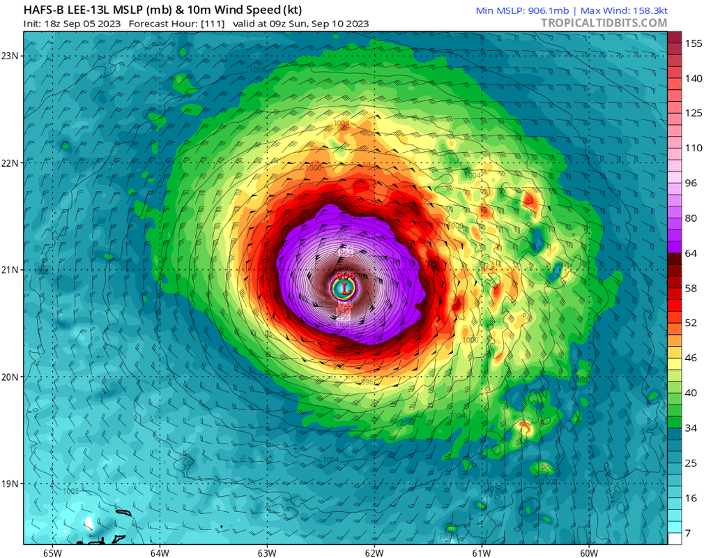
The 18Z HAFS-B depicts the cyclone becoming not only very intense, but also extremely large through the course of multiple EWRCs as was seen with Irma.

HWRF is interesting, multiple runs now for this system have depicted a large eye with minimal banding, approaching (but not quite meeting, IMO) "A-word" criteria.
0 likes   

Ianswfl
Category 1
Category 1
Posts: 482
Joined: Thu Mar 23, 2023 11:11 pm

Re: ATL: LEE - Models

#392 Postby Ianswfl » Tue Sep 05, 2023 7:35 pm

SFLcane wrote:


That batch still recurves but worth watching if it’s the start of some trend maybe.


One member has a Matthew like track. Even for Florida I wouldn't discount this yet. Slower movement and some more stronger ridging and we could be in play. GFS Ensembles kinda trying to pull a Georges 2.0 over the DR and Cuba. Run ends there. A couple more model cycles and might have more ensemble members into Florida if they keep shifting at this rate.
2 likes   

LarryWx
Category 5
Category 5
Posts: 6246
Joined: Sun Sep 07, 2003 2:04 pm
Location: GA

Re: ATL: LEE - Models

#393 Postby LarryWx » Tue Sep 05, 2023 7:40 pm

Category5Kaiju wrote:
TheDreamTraveler wrote:
SouthFLTropics wrote:I won't take my eyes off of this thing until it is safely headed away into the North Atlantic. I've see this movie too many times and didn't like the ending. I'm not surprised at all by the split camp in the 18z GEFS. I suspect we haven't seen the last of this. I think the UKMET has been sniffing out a pattern change coming all along. Odds still favor it to head up and out, but at this point nothing is off of the table.


Honestly wouldn't be the first time I've seen the UKMET sniff out something that the GFS and Euro were both missing.


I could be very wrong with this, but didn't the UKMET nail the landfall location of Ian last year?


Yes it did for both FL and SC landfalls. And it did better than the GFS and CMC for Idalia's FL landfall.
0 likes   
Personal Forecast Disclaimer:
The posts in this forum are NOT official forecasts and should not be used as such. They are just the opinion of the poster and may or may not be backed by sound meteorological data. They are NOT endorsed by any professional institution or storm2k.org. For official information, please refer to the NHC and NWS products.

User avatar
gatorcane
S2K Supporter
S2K Supporter
Posts: 23689
Age: 47
Joined: Sun Mar 13, 2005 3:54 pm
Location: Boca Raton, FL

Re: ATL: LEE - Models

#394 Postby gatorcane » Tue Sep 05, 2023 7:44 pm

Most models recurve (future powerful) Lee over the SW Atlantic. As far as 2017 and Irma which I see referenced in this thread, models clearly underestimated the ridge that year but then again that was a year with a very strong Bermuda High feature. Even so around day 10 the Euro was the first model to sniff out the big ridge showing Irma very near the Florida Keys (remarkable how accurate it was). This year the Bermuda High has been on the weak or non-existent side so would be surprised if models start to show some massive ridge at this point to drive Lee westward all the way to Florida. You can thank El Niño for that.
2 likes   

User avatar
Category5Kaiju
Category 5
Category 5
Posts: 4052
Joined: Thu Dec 24, 2020 12:45 pm
Location: Seattle

Re: ATL: LEE - Models

#395 Postby Category5Kaiju » Tue Sep 05, 2023 7:48 pm

gatorcane wrote:Most models recurve (future powerful) Lee over the SW Atlantic. As far as 2017 and Irma which I see referenced in this thread, models clearly underestimated the ridge that year but then again that was a year with a very strong Bermuda High feature. Even so around day 10 the Euro was the first model to sniff out the big ridge showing Irma very near the Florida Keys (remarkable how accurate it was). This year the Bermuda High has been on the weak or non-existent side so would be surprised if models start to show some massive ridge at this point to drive Lee westward all the way to Florida. You can thank El Niño for that.


Then for 2018, which was also an El Nino year, was it just a freak occurrence that Florence went all the way from the Cape Verde Islands to North Carolina without recurving on out to sea? Or in 1965, which was another moderate El Nino year, Betsy looping and hitting Florida and Louisiana?
2 likes   
Unless explicitly stated, all info in my posts is based on my own opinions and observations. Tropical storms and hurricanes can be extremely dangerous. Do not think you can beat Mother Nature. Refer to an accredited weather research agency or meteorologist if you need to make serious decisions regarding an approaching storm.

User avatar
ScottNAtlanta
Category 5
Category 5
Posts: 2360
Joined: Sat May 25, 2013 3:11 pm
Location: Atlanta, GA

Re: ATL: LEE - Models

#396 Postby ScottNAtlanta » Tue Sep 05, 2023 7:55 pm

Here is a short term trend to watch. Both the GFS and Euro have Lee gain over a degree in latitude in the next 24 hours. Lets see if that verifies because if anything, the center looks like it is forming south of where they initialize
4 likes   
The posts in this forum are NOT official forecast and should not be used as such. They are just the opinion of the poster and may or may not be backed by sound meteorological data. They are NOT endorsed by any professional institution or storm2k.org. For official information, please refer to the NHC and NWS products.

Ianswfl
Category 1
Category 1
Posts: 482
Joined: Thu Mar 23, 2023 11:11 pm

Re: ATL: LEE - Models

#397 Postby Ianswfl » Tue Sep 05, 2023 8:03 pm

gatorcane wrote:Most models recurve (future powerful) Lee over the SW Atlantic. As far as 2017 and Irma which I see referenced in this thread, models clearly underestimated the ridge that year but then again that was a year with a very strong Bermuda High feature. Even so around day 10 the Euro was the first model to sniff out the big ridge showing Irma very near the Florida Keys (remarkable how accurate it was). This year the Bermuda High has been on the weak or non-existent side so would be surprised if models start to show some massive ridge at this point to drive Lee westward all the way to Florida. You can thank El Niño for that.


The UKmet also snuffed out Irma's dive over Cuba too first I recall. Saved from a large, strong cat4 from going up the spine of FL and give SEFl and SWFL major hurricane force winds. I remember those whacky 892mb hurricanes the GFS and Euro were striking Miami with during Irma.
3 likes   

User avatar
chris_fit
Category 5
Category 5
Posts: 3222
Age: 42
Joined: Wed Sep 10, 2003 11:58 pm
Location: Tampa Bay Area, FL

Re: ATL: LEE - Models

#398 Postby chris_fit » Tue Sep 05, 2023 8:07 pm

Eyeballing 18z EPS... More South at 100+hrs
1 likes   

Ianswfl
Category 1
Category 1
Posts: 482
Joined: Thu Mar 23, 2023 11:11 pm

Re: ATL: LEE - Models

#399 Postby Ianswfl » Tue Sep 05, 2023 8:36 pm

chris_fit wrote:Eyeballing 18z EPS... More South at 100+hrs


Yep. Quite a bit more south. Hard to tell but a bit more of them look to have a wnw bend to them at the end of it. Those southern members from 12z now take it over the middle of Hispaniola, Georges like! Find it odd we are seeing a couple members taking it over the shredder now. Like I said seems like a major pattern change happening. I wouldn't discount it in Florida just yet.

https://www.tropicaltidbits.com/analysi ... 0518&fh=75
0 likes   

User avatar
Emmett_Brown
Category 5
Category 5
Posts: 1432
Joined: Wed Aug 24, 2005 9:10 pm
Location: Sarasota FL

Re: ATL: LEE - Models

#400 Postby Emmett_Brown » Tue Sep 05, 2023 8:36 pm

chris_fit wrote:Eyeballing 18z EPS... More South at 100+hrs


I don't have an image to post, but interesting that the stronger members seems to be on the left side of the member consensus swath during the first 72 hours.
0 likes   


Return to “2023”

Who is online

Users browsing this forum: No registered users and 35 guests