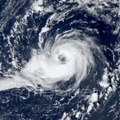
The circulation is still somewhat disorganized as smaller eddies rotate around the larger but rather broad main vortex, however, the convection becames increasingly better organized and the upper-level outflow has already started to develop on the northern side. At 05Z a ship (ZCEE2) reported sustained winds of 43 kt and pressure of 1005.3 hPa NW of the center (36.0N, 16.4E).
The models indicate the formation of a well-defined poleward outflow channel by tomorrow, which could help the system to intensify more quickly. Most of the models show a medium-range TS by Sunday morning, but the GFS and the Australian model are a bit stronger, while the Swiss model continues to strengthen the cyclone into a hurricane, now even in the late evening hours of Saturday.


