https://twitter.com/TropicalTidbits/status/1699939104245555556
ATL: LEE - Post-Tropical - Discussion
Moderator: S2k Moderators
-
cycloneye

- Admin

- Posts: 149298
- Age: 69
- Joined: Thu Oct 10, 2002 10:54 am
- Location: San Juan, Puerto Rico
Re: ATL: LEE - Hurricane - Discussion
4 likes
Visit the Caribbean-Central America Weather Thread where you can find at first post web cams,radars
and observations from Caribbean basin members Click Here
and observations from Caribbean basin members Click Here

Re: ATL: LEE - Hurricane - Discussion
GCANE wrote:The eye drop showed 74% RH at 850mb.
It looks to be drying out,
If trend continues to show lower RH on subsequent eye drops, may be an indicator for an onset EWRC.
Look for mesovorts in the eye to confirm.
Not seeing any signs in the recon data, nor in microwave passes from just 2 hours ago.
1 likes
Irene '11 Sandy '12 Hermine '16 5/15/2018 Derecho Fay '20 Isaias '20 Elsa '21 Henri '21 Ida '21
I am only a meteorology enthusiast who knows a decent amount about tropical cyclones. Look to the professional mets, the NHC, or your local weather office for the best information.
I am only a meteorology enthusiast who knows a decent amount about tropical cyclones. Look to the professional mets, the NHC, or your local weather office for the best information.

Re: ATL: LEE - Hurricane - Discussion
cycloneye wrote:https://twitter.com/TropicalTidbits/status/1699939104245555556
Don't forget that even the aggressive hurricane models only showed RI starting tonight, so Lee was 12 hours ahead of schedule.
1 likes
TC naming lists: retirements and intensity
Most aggressive Advisory #1's in North Atlantic (cr. kevin for starting the list)
Most aggressive Advisory #1's in North Atlantic (cr. kevin for starting the list)
Re: ATL: LEE - Hurricane - Discussion
aspen wrote:GCANE wrote:The eye drop showed 74% RH at 850mb.
It looks to be drying out,
If trend continues to show lower RH on subsequent eye drops, may be an indicator for an onset EWRC.
Look for mesovorts in the eye to confirm.
Not seeing any signs in the recon data, nor in microwave passes from just 2 hours ago.
The eye is quickly contracting on IR.
0 likes

Re: ATL: LEE - Hurricane - Discussion
Recon fix is slightly south and west of forecast track
2 likes

Re: ATL: LEE - Hurricane - Discussion
GCANE wrote:The eye drop showed 74% RH at 850mb.
It looks to be drying out,
If trend continues to show lower RH on subsequent eye drops, may be an indicator for an onset EWRC.
Look for mesovorts in the eye to confirm.
What does eye RH have to do with EWRC? It seems acausal to me that an early EWRC indicator would come from the absolute center of the system.
0 likes
Re: ATL: LEE - Hurricane - Discussion
aspen wrote:GCANE wrote:The eye drop showed 74% RH at 850mb.
It looks to be drying out,
If trend continues to show lower RH on subsequent eye drops, may be an indicator for an onset EWRC.
Look for mesovorts in the eye to confirm.
Not seeing any signs in the recon data, nor in microwave passes from just 2 hours ago.
This is the first signs, wont see it on recon flight level winds for a few hours if indeed an EWRC is starting.
0 likes
-
Blown Away

- S2K Supporter

- Posts: 10253
- Joined: Wed May 26, 2004 6:17 am
Re: ATL: LEE - Hurricane - Discussion
the core of Lee and its damaging winds north of the Leeward Islands.
There is uncertainty in any northward turn of Lee beginning early
next week, but it is too soon to speculate about specific potential
impacts a week or more out.
Ok, models are overwhelmingly making a N turn well N of the NE Caribbean. The NHC cone hints a slight WNW bend at day 5. The uncertainty has to be will in turn N at 66W or 70W? Not sure what would make the NHC make that statement??
0 likes
Hurricane Eye Experience: David 79, Irene 99, Frances 04, Jeanne 04, Wilma 05… Hurricane Brush Experience: Andrew 92, Erin 95, Floyd 99, Matthew 16, Irma 17, Ian 22, Nicole 22…
-
Sciencerocks
- Category 5

- Posts: 10181
- Age: 40
- Joined: Thu Jul 06, 2017 1:51 am

-
Hypercane_Kyle

- Category 5
- Posts: 3465
- Joined: Sat Mar 07, 2015 7:58 pm
- Location: Cape Canaveral, FL
Re: ATL: LEE - Hurricane - Discussion
Off-hand, the only storm that I can think of that blew up quite as quickly as Lee did was Maria.
0 likes
My posts are my own personal opinion, defer to the National Hurricane Center (NHC) and other NOAA products for decision making during hurricane season.
-
ElectricStorm

- Category 5
- Posts: 5144
- Age: 25
- Joined: Tue Aug 13, 2019 11:23 pm
- Location: Norman, OK
Re: ATL: LEE - Hurricane - Discussion
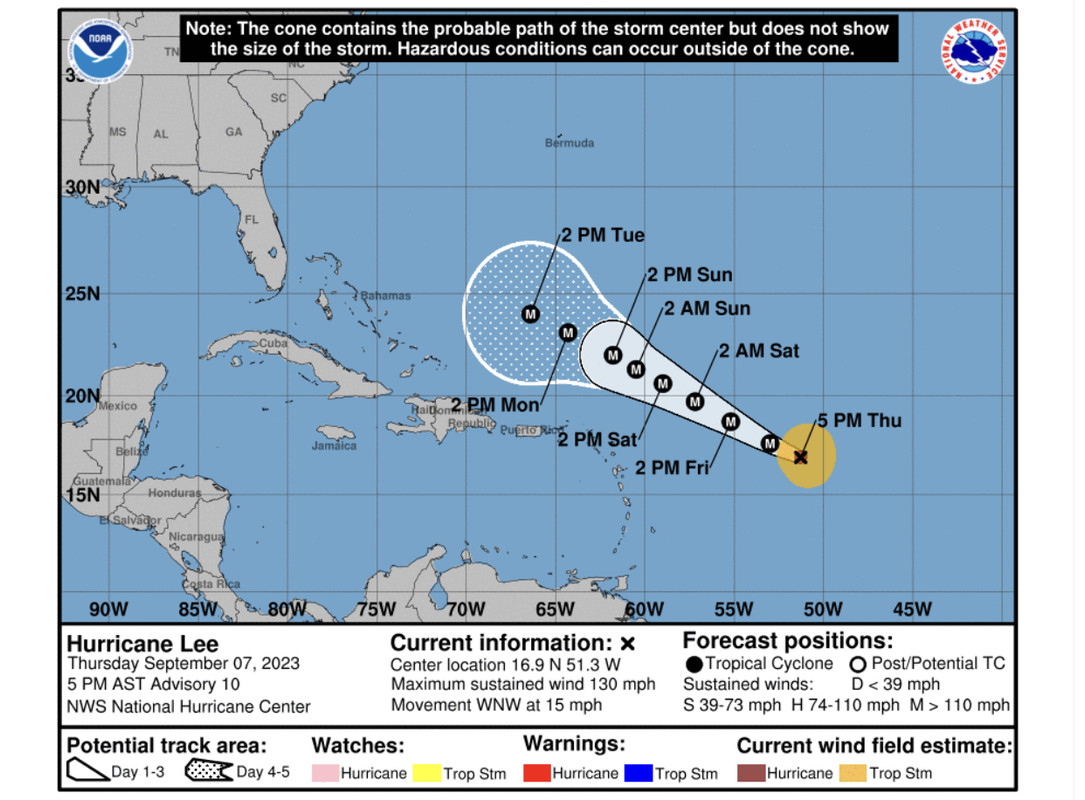
AL, 13, 2023090800, , BEST, 0, 170N, 518W, 135, 933, HU,
0 likes
B.S Meteorology, University of Oklahoma '25
Please refer to the NHC, NWS, or SPC for official information.
Please refer to the NHC, NWS, or SPC for official information.

Re: ATL: LEE - Hurricane - Discussion
This is certainly a historic evening, like last. I was hoping both Lee and Jova would be CAT5s at the same time but no dice. I'm anticipating how fast Lee's pressure is dropping between passes and this contracting of the eye - a sign of a Jova-like eye coming? It would be strange for a ERC this fast in the middle of EI (Wilma's more precarious pinhole eye lasted longer which is far more unstable than Lee's core).
1 likes
Re: ATL: LEE - Hurricane - Discussion
kronotsky wrote:GCANE wrote:The eye drop showed 74% RH at 850mb.
It looks to be drying out,
If trend continues to show lower RH on subsequent eye drops, may be an indicator for an onset EWRC.
Look for mesovorts in the eye to confirm.
What does eye RH have to do with EWRC? It seems acausal to me that an early EWRC indicator would come from the absolute center of the system.
Check this paper
https://journals.ametsoc.org/view/journ ... 0349.1.xml
1 likes
-
WalterWhite

- Category 1

- Posts: 342
- Joined: Fri Mar 17, 2023 5:53 pm
Re: ATL: LEE - Hurricane - Discussion
ElectricStorm wrote:AL, 13, 2023090800, , BEST, 0, 170N, 518W, 135, 933, HU,
This seems premature given that recon has not completed its mission yet.
0 likes
Re: ATL: LEE - Hurricane - Discussion
WalterWhite wrote:ElectricStorm wrote:AL, 13, 2023090800, , BEST, 0, 170N, 518W, 135, 933, HU,
This seems premature given that recon has not completed its mission yet.
Best track data is updated at 0z regardless of recon or not. It can be corrected later if needed.
7 likes

Re: ATL: LEE - Hurricane - Discussion
Blown Away wrote:[url]https://i.postimg.cc/G3XM0cHM/4546-E463-FD0-A-4946-97-DB-CD52-F95-EDAAF.jpg [/url]the core of Lee and its damaging winds north of the Leeward Islands.
There is uncertainty in any northward turn of Lee beginning early
next week, but it is too soon to speculate about specific potential
impacts a week or more out.
Ok, models are overwhelmingly making a N turn well N of the NE Caribbean. The NHC cone hints a slight WNW bend at day 5. The uncertainty has to be will in turn N at 66W or 70W? Not sure what would make the NHC make that statement??
Because models are still models, and the timeframe is a week away.
NOAA's own model (HAFS) shows a prolonged west run before it ends. It's just far too early to tell what's going to happen.
1 likes
Re: ATL: LEE - Hurricane - Discussion
GCANE wrote:kronotsky wrote:GCANE wrote:The eye drop showed 74% RH at 850mb.
It looks to be drying out,
If trend continues to show lower RH on subsequent eye drops, may be an indicator for an onset EWRC.
Look for mesovorts in the eye to confirm.
What does eye RH have to do with EWRC? It seems acausal to me that an early EWRC indicator would come from the absolute center of the system.
Check this paper
https://journals.ametsoc.org/view/journ ... 0349.1.xml
I think you're drawing the wrong conclusion from the paper. Strong tropical cyclones in general have warm and dry eyes, and the large majority of EWRCs take place in strong storms, so purely by the selection criteria you would expect a dry eye at the onset of the EWRC. Dry eyes are a sign of a healthy circulation that is disrupted by an EWRC, which is why the relative humidity increases by the end of the EWRC as in figure 2.
2 likes
Re: ATL: LEE - Hurricane - Discussion
Calculated probability of an EWRC has increased significantly
https://tropic.ssec.wisc.edu/real-time/ ... leERC.html
https://tropic.ssec.wisc.edu/real-time/ ... leERC.html
2 likes
-
dukeblue219
- S2K Supporter
- Posts: 556
- Joined: Fri Sep 30, 2016 3:52 pm
Re: ATL: LEE - Hurricane - Discussion
WalterWhite wrote:ElectricStorm wrote:AL, 13, 2023090800, , BEST, 0, 170N, 518W, 135, 933, HU,
This seems premature given that recon has not completed its mission yet.
It's just the facts as they exist on the hour. Nothing more, nothing less, and not an official advisory.
0 likes
Who is online
Users browsing this forum: No registered users and 54 guests