

ATL: LEE - Models
Moderator: S2k Moderators
Re: ATL: LEE - Models
1 likes
ヤンデレ女が寝取られるているのを見たい!!!
ECMWF ensemble NWPAC plots: https://ecmwfensnwpac.imgbb.com/
Multimodel NWPAC plots: https://multimodelnwpac.imgbb.com/
GFS Ensemble NWPAC plots (16 & 35 day forecast): https://gefsnwpac.imgbb.com/
Plots updated automatically
ECMWF ensemble NWPAC plots: https://ecmwfensnwpac.imgbb.com/
Multimodel NWPAC plots: https://multimodelnwpac.imgbb.com/
GFS Ensemble NWPAC plots (16 & 35 day forecast): https://gefsnwpac.imgbb.com/
Plots updated automatically

Re: ATL: LEE - Models
18z HAFS: 900 mbar and 175-180 kt for A, 912 mbar and 170 kt for B

2 likes
Irene '11 Sandy '12 Hermine '16 5/15/2018 Derecho Fay '20 Isaias '20 Elsa '21 Henri '21 Ida '21
I am only a meteorology enthusiast who knows a decent amount about tropical cyclones. Look to the professional mets, the NHC, or your local weather office for the best information.
I am only a meteorology enthusiast who knows a decent amount about tropical cyclones. Look to the professional mets, the NHC, or your local weather office for the best information.
-
Hypercane_Kyle

- Category 5

- Posts: 3465
- Joined: Sat Mar 07, 2015 7:58 pm
- Location: Cape Canaveral, FL
Re: ATL: LEE - Models
180 knots would exceed monsters like Irma and Dorian. Lee would stand on its own, unique class if the HAFS-A were correct.
3 likes
My posts are my own personal opinion, defer to the National Hurricane Center (NHC) and other NOAA products for decision making during hurricane season.
-
WalterWhite

- Category 1

- Posts: 342
- Joined: Fri Mar 17, 2023 5:53 pm
Re: ATL: LEE - Models
Hypercane_Kyle wrote:180 knots would exceed monsters like Irma and Dorian. Lee would stand on its own, unique class if the HAFS-A were correct.
180 knots would exceed Wilma and Allen for crying out loud.
6 likes

Re: ATL: LEE - Models
Salute!
Are we looking at a large Camille? Wind, not other aspects.
Sure glad that fellow is way out in the Atlantic for a coupla days...
So looking for a duplicate of the infamous Long Island storm 90 years +/- ago ?
Gonna be real interesting next 5 days, ya think?
Gums sends...
Are we looking at a large Camille? Wind, not other aspects.
Sure glad that fellow is way out in the Atlantic for a coupla days...
So looking for a duplicate of the infamous Long Island storm 90 years +/- ago ?
Gonna be real interesting next 5 days, ya think?
Gums sends...
6 likes
Re: ATL: LEE - Models
LarryWx wrote:Regarding the 12Z EPS, I count a total of ~9 US hits excluding operational through 240 hours with ~5 hitting ME (excluding operational), ~3 hitting MA, and 1 hitting NY. Plus a couple more probably will hit on this run after 240. So, ~18%+ US hits on the 12Z EPS not including the operational, which means likely at least on par with the 20% of the previously most active 0Z of today. Or ~20%+ already if including operational.
The point is that the significant increase in hits of the last run was maintained on this new run (12Z).
So, on the 12Z EPS through 240 excluding the operational, I have 9 hitting the US: 5 ME, 3 MA, and 1 NY. After 240, I count 2 ME and 1 NJ. So, grand total for 12Z is 12 (24%) meaning the most of any run yet with 7 ME, 3 MA, 1 NY, and 1 NJ with hit dates 9/15-19.
Summary of recent EPS runs' US hits:
9/7 12Z: 12 (24%) 9/15-19 (7 ME, 3 MA, 1 NY, 1 NJ)
9/7 0Z: 10 (20%) 9/15-18 (5 ME, 5 MA)
12Z 9/6: 3 (6%) 9/15-18 (2 ME, 1 MA)
0Z 9/6: 5 (10%)
12Z 9/5: 2 (4%)
0Z 9/5: 4 (8%)
12Z 9/4: 1 (2%)
0Z 9/4: 2 (4%)
Last edited by LarryWx on Thu Sep 07, 2023 6:47 pm, edited 1 time in total.
2 likes
Personal Forecast Disclaimer:
The posts in this forum are NOT official forecasts and should not be used as such. They are just the opinion of the poster and may or may not be backed by sound meteorological data. They are NOT endorsed by any professional institution or storm2k.org. For official information, please refer to the NHC and NWS products.
The posts in this forum are NOT official forecasts and should not be used as such. They are just the opinion of the poster and may or may not be backed by sound meteorological data. They are NOT endorsed by any professional institution or storm2k.org. For official information, please refer to the NHC and NWS products.

Re: ATL: LEE - Models
Hypercane_Kyle wrote:I'm sure it's been pointed out, but the HAFS-B model takes this to 200mph tomorrow morning.
https://i.imgur.com/ID9NyD7.png
That would certainly nudge the patio furniture around.
7 likes
Andy D
(For official information, please refer to the NHC and NWS products.)
(For official information, please refer to the NHC and NWS products.)
-
MEANINGLESS_NUMBERS
- Category 2

- Posts: 503
- Joined: Mon Nov 02, 2020 1:43 pm
Re: ATL: LEE - Models
chaser1 wrote:Hypercane_Kyle wrote:I'm sure it's been pointed out, but the HAFS-B model takes this to 200mph tomorrow morning.
https://i.imgur.com/ID9NyD7.png
That would certainly nudge the patio furniture around.
That is the power of an EF5 tornado but hurricane-sized.
3 likes
Emily '87, Felix '95, Gert '99, Fabian '03, Humberto '19, Paulette '20, Teddy '20, Fiona '22, Lee '23, Ernesto '24, Humberto/Imelda '25
-
ThunderForce

- Tropical Storm

- Posts: 208
- Age: 26
- Joined: Tue Sep 27, 2022 6:20 pm
- Location: Calhoun County, Florida
Re: ATL: LEE - Models
A sustained wind speed of 180 knots would be about 207 MPH. For the record, the highest recorded maximum sustained winds in an Atlantic hurricane so far is Allen 1980 which was 190 MPH.
If this manages to verify, Lee would be roughly 17 MPH stronger than Allen. That's absolutely insane.
If this manages to verify, Lee would be roughly 17 MPH stronger than Allen. That's absolutely insane.
4 likes
Please refer to the NWS, NHC, SPC or a professional meteorologist for information and decision making during storms.


Re: ATL: LEE - Models
chaser1 wrote:Hypercane_Kyle wrote:I'm sure it's been pointed out, but the HAFS-B model takes this to 200mph tomorrow morning.
https://i.imgur.com/ID9NyD7.png
That would certainly nudge the patio furniture around.
Nudge it? LOL it would wind up in another state..............
2 likes
-
Hybridstorm_November2001

- S2K Supporter

- Posts: 2817
- Joined: Sat Aug 21, 2004 2:50 pm
- Location: SW New Brunswick, Canada
- Contact:
Re: ATL: LEE - Models
I'm starting to get worried about this trend. I live along the Maine/New Brunswick border near Saint Stephen and Calis (SE of S.S., specifically along where the Saint Croix River extends into the Great Passamaquoddy Bay). My elderly uncle from Pembroke, Maine is staying with us and he is suffering from early-stage kidney failure. It is under control but he is dependent on dialysis at least once a week. Our power grid is trash and has been since Arthur in 2014. I have a generator but no dialysis machine. Also, there are tons of trees around this area so roads could be blocked maybe for days if we get hit as hard as some of the models indicate. If we are in the cone four days out I'll see if I can check him into a hospital.
Another uncle and his wife who live right on the coast further east at Saint John, New Brunswick are going on a vacation to Quebec starting Monday they will not be back until next Saturday or Sunday. I told them to a least secure their property and boat but they laughed saying it "won't be a big deal".
So, yeah, lots of worries. Hopefully, the worries will only ever be that and this monster will turn well east before land.
5 likes
-
Blown Away

- S2K Supporter
- Posts: 10253
- Joined: Wed May 26, 2004 6:17 am
Re: ATL: LEE - Models
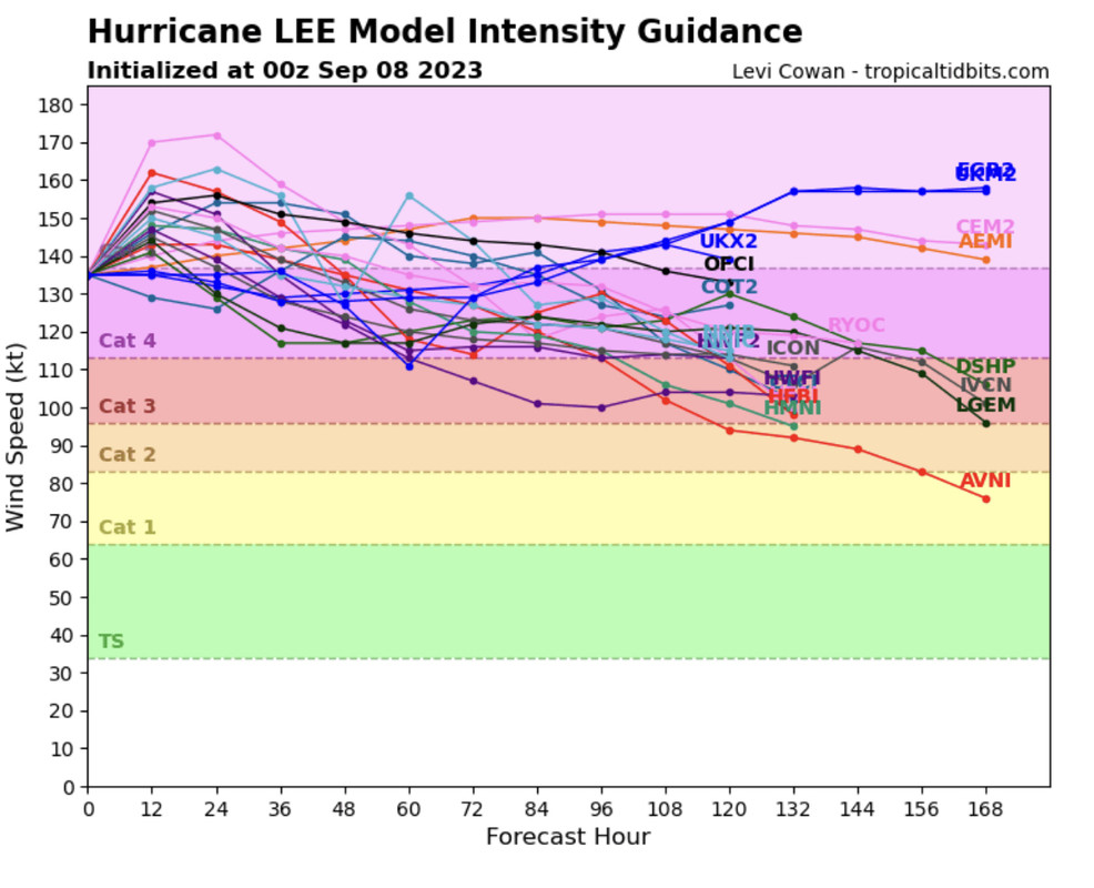
We don’t see a graphic like this very often…
6 likes
Hurricane Eye Experience: David 79, Irene 99, Frances 04, Jeanne 04, Wilma 05… Hurricane Brush Experience: Andrew 92, Erin 95, Floyd 99, Matthew 16, Irma 17, Ian 22, Nicole 22…
Re: ATL: LEE - Models
The hafs b has this moving west then a tad wsw at the end of the run. Hafs a same thing end of run and hafs a similar. Due west. The moment of truth comes next tue I think. Keep getting pushed west like a few ensembles members or turn north.
1 likes
Re: ATL: LEE - Models
My mind keeps going back to both the HAFS A & B hurricane models from yesterday as well as today. Not to say that the EURO and GFS did not pick up on such a forecasted pattern at 120 hr's, but both hurricane model's resolution depicting Lee practically catching up to what appeared to be a newly developed H5 centered around the Florida Straits. A couple of days ago I believed that nearly every model was depicting a deep southwesterly flow as Lee approached 65W-70W as a result of the strong shortwave into the N GOM by next Tue. On both regional models however, it appeared as if the trough had turned full negative with basically slack winds over the E. Gulf instead and northerly steering just to the east of a building H5. Assuming "IF" Lee were slightly further south & west by next Monday, then it would appear that the only dominent steering would practically be northerly under this newly bridged or established H5 anticyclone. Seemingly like the prior H5 that was building west along with the WNW forward motion of Lee, is nearly "handing -off" Lee to a new or weaker level ridge to the southwest. To me, that set-up might imply a SW motion into Cuba. Timing of course would dictate whether this might reflect a sharpening trough allowing Lee to split some weakness along an existant NE/SW angled ridge and turn NNW as forecast.... OR possibly reflect the negatively tilted trough energy pulling out with mid level heights quickly filling in its wake? If none of the above ever transpires though and simply leaving Lee to drift for days well east of the Bahamas, a deeper trough looks to eventually enter the picture by later next week to sweep Lee northward (if still in the neighborhood). Anyhow, the odd tone of NHC's 5:00pm discussion left me pondering the thought.
2 likes
Andy D
(For official information, please refer to the NHC and NWS products.)
(For official information, please refer to the NHC and NWS products.)
Re: ATL: LEE - Models
Joe Snow wrote:chaser1 wrote:Hypercane_Kyle wrote:I'm sure it's been pointed out, but the HAFS-B model takes this to 200mph tomorrow morning.
https://i.imgur.com/ID9NyD7.png
That would certainly nudge the patio furniture around.
Nudge it? LOL it would wind up in another state..............

0 likes
Andy D
(For official information, please refer to the NHC and NWS products.)
(For official information, please refer to the NHC and NWS products.)
-
Blown Away
- S2K Supporter
- Posts: 10253
- Joined: Wed May 26, 2004 6:17 am
Re: ATL: LEE - Models
Ianswfl wrote:The hafs b has this moving west then a tad wsw at the end of the run. Hafs a same thing end of run and hafs a similar. Due west. The moment of truth comes next tue I think. Keep getting pushed west like a few ensembles members or turn north.
18z a whole degree slower and does go above then back below 23N at end run.
1 likes
Hurricane Eye Experience: David 79, Irene 99, Frances 04, Jeanne 04, Wilma 05… Hurricane Brush Experience: Andrew 92, Erin 95, Floyd 99, Matthew 16, Irma 17, Ian 22, Nicole 22…
Re: ATL: LEE - Models
Blown Away wrote:Ianswfl wrote:The hafs b has this moving west then a tad wsw at the end of the run. Hafs a same thing end of run and hafs a similar. Due west. The moment of truth comes next tue I think. Keep getting pushed west like a few ensembles members or turn north.
18z a whole degree slower and does go above then back below 23N at end run.
What concerns me. The intense storms like strong cat4s and the cat5s seem to go more south when influenced by a high to the north. Saw it with Irma, saw it with Andrew.
The 18z euro ensemble is quite a bit south vs 12z and some of the members are bending more west at the end of the run. Compared to the full 12z versions that curve north in the same area.
https://weather.us/cyclone-tracks/euro/ ... 8-240.html
1 likes
-
AxaltaRacing24
- Category 5
- Posts: 1774
- Age: 25
- Joined: Wed Jul 27, 2016 11:14 am
- Location: Jupiter, FL
Re: ATL: LEE - Models
Ianswfl wrote:Blown Away wrote:Ianswfl wrote:The hafs b has this moving west then a tad wsw at the end of the run. Hafs a same thing end of run and hafs a similar. Due west. The moment of truth comes next tue I think. Keep getting pushed west like a few ensembles members or turn north.
18z a whole degree slower and does go above then back below 23N at end run.
What concerns me. The intense storms like strong cat4s and the cat5s seem to go more south when influenced by a high to the north. Saw it with Irma, saw it with Andrew.
The 18z euro ensemble is quite a bit south vs 12z and some of the members are bending more west at the end of the run. Compared to the full 12z versions that curve north in the same area.
https://weather.us/cyclone-tracks/euro/ ... 8-240.html
Yeah still a chance it come close to the extreme SE Bahamas before it turns at this rate.
1 likes
Re: ATL: LEE - Models
chaser1 wrote:My mind keeps going back to both the HAFS A & B hurricane models from yesterday as well as today. Not to say that the EURO and GFS did not pick up on such a forecasted pattern at 120 hr's, but both hurricane model's resolution depicting Lee practically catching up to what appeared to be a newly developed H5 centered around the Florida Straits. A couple of days ago I believed that nearly every model was depicting a deep southwesterly flow as Lee approached 65W-70W as a result of the strong shortwave into the N GOM by next Tue. On both regional models however, it appeared as if the trough had turned full negative with basically slack winds over the E. Gulf instead and northerly steering just to the east of a building H5. Assuming "IF" Lee were slightly further south & west by next Monday, then it would appear that the only dominent steering would practically be northerly under this newly bridged or established H5 anticyclone. Seemingly like the prior H5 that was building west along with the WNW forward motion of Lee, is nearly "handing -off" Lee to a new or weaker level ridge to the southwest. To me, that set-up might imply a SW motion into Cuba. Timing of course would dictate whether this might reflect a sharpening trough allowing Lee to split some weakness along an existant NE/SW angled ridge and turn NNW as forecast.... OR possibly reflect the negatively tilted trough energy pulling out with mid level heights quickly filling in its wake? If none of the above ever transpires though and simply leaving Lee to drift for days well east of the Bahamas, a deeper trough looks to eventually enter the picture by later next week to sweep Lee northward (if still in the neighborhood). Anyhow, the odd tone of NHC's 5:00pm discussion left me pondering the thought.
Actually, a few GFS ensembles members and Euro ensembles members had the SW motion into Cuba, or just north of it a couple days ago. Euro ensembles shifted way north, but the 18z euro ensembles are trending a lot further south than 12z and too showing bending like Hafs B.
1 likes
-
SconnieCane
- Category 5
- Posts: 1013
- Joined: Thu Aug 02, 2018 5:29 pm
- Location: Madison, WI
Re: ATL: LEE - Models
Ianswfl wrote:Actually, a few GFS ensembles members and Euro ensembles members had the SW motion into Cuba, or just north of it a couple days ago. Euro ensembles shifted way north, but the 18z euro ensembles are trending a lot further south than 12z and too showing bending like Hafs B.
Windshield wiper mode in full effect. Some things never change.
1 likes
Who is online
Users browsing this forum: No registered users and 17 guests