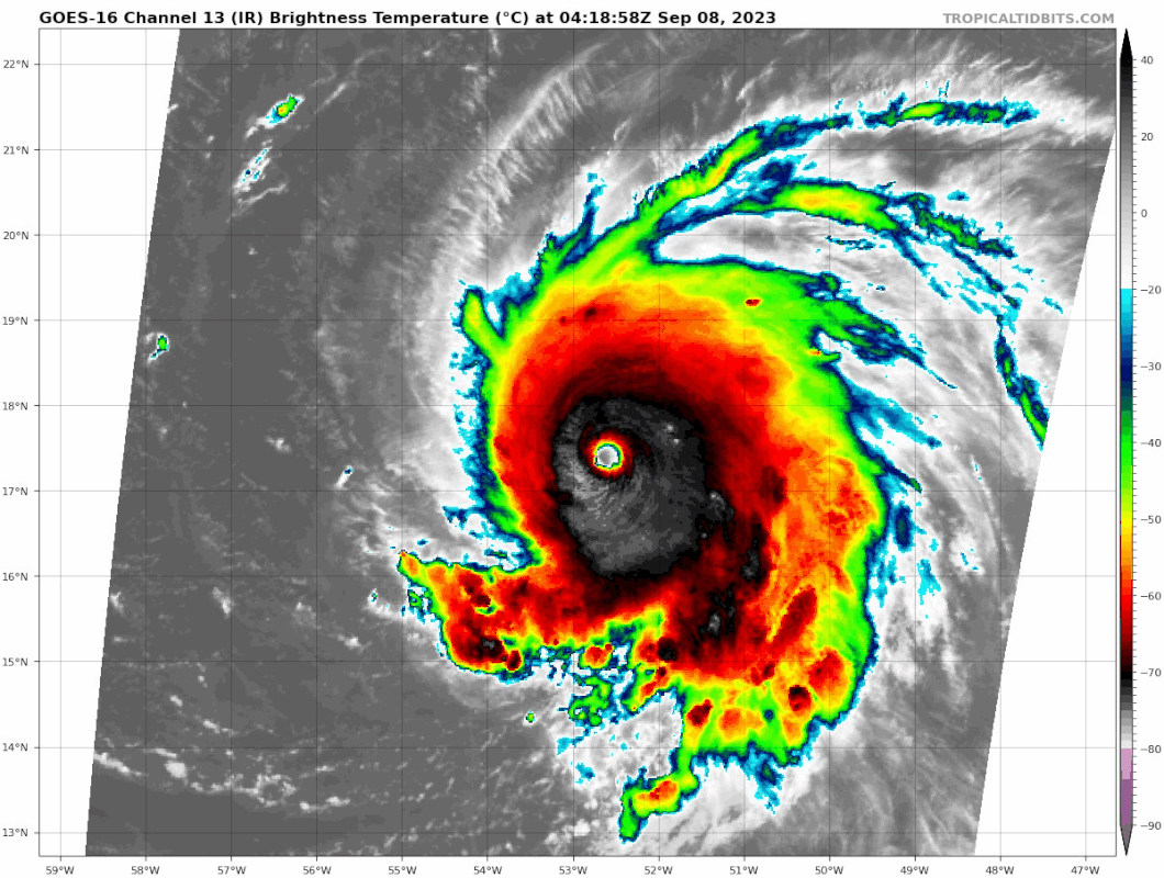
ATL: LEE - Post-Tropical - Discussion

Moderator: S2k Moderators

Message
Author
RevanTheJedi96
Tropical Storm
Tropical Storm
Posts: 106
Joined: Wed Sep 01, 2021 10:40 am

Re: ATL: LEE - Hurricane - Discussion

#1141 Postby RevanTheJedi96 » Thu Sep 07, 2023 11:44 pm

Hurricaneman wrote:
CryHavoc wrote:
psyclone wrote:This is a remarkable peak season system. It's a joy to watch it go crazy while safely offshore.


Practically a dream system to those of us that just want to watch the 'canes blow. Even if it results in a bit less traffic than usual.

Edit: It would be insensitive to forget to mention that I am a bit worried about Atlantic Canada. Esp as the storm continues to nudge S and W of the target track.


I honestly wouldn’t rule out eastern New England yet, the models are adjusting west and as long as that happens eastern New England could get it pretty bad if this keeps adjusting west


Can't really rule out the East Coast above the Carolinas yet tbh but yeah as a Mainer it's weird to have this beast of a storm potentially heading right towards you.
2 likes   

Sciencerocks
Category 5
Category 5
Posts: 9155
Age: 39
Joined: Thu Jul 06, 2017 1:51 am

Re: ATL: LEE - Hurricane - Discussion

#1142 Postby Sciencerocks » Thu Sep 07, 2023 11:47 pm

1 likes   

Poonwalker
Category 1
Category 1
Posts: 270
Joined: Tue Sep 20, 2022 11:12 am

Re: ATL: LEE - Hurricane - Discussion

#1143 Postby Poonwalker » Thu Sep 07, 2023 11:47 pm

Kinda saw this coming. All it was going to take was ideal conditions and the rocket fuel was there. Iam now glad I didn’t buy a condo on the water when I had the chance. Flood insurance has doubled here in Florida in the last couple years. I can’t imagine what will happen if a cat 5 like this hits where I live near the Tampa Bay region. Thank god this one looks to be scooting north of land so far.
0 likes   

User avatar
Teban54
Category 5
Category 5
Posts: 3206
Joined: Sat May 19, 2018 1:19 pm

Re: ATL: LEE - Hurricane - Discussion

#1144 Postby Teban54 » Thu Sep 07, 2023 11:47 pm


Peak is expected to be at 180mph! That’s the strongest explicit NHC forecast on record!
3 likes   

User avatar
Teban54
Category 5
Category 5
Posts: 3206
Joined: Sat May 19, 2018 1:19 pm

Re: ATL: LEE - Hurricane - Discussion

#1145 Postby Teban54 » Thu Sep 07, 2023 11:52 pm

New convective burst with -80C pixels showing up. Lee has not done with intensifying yet.
Image
2 likes   

CrazyC83
Professional-Met
Professional-Met
Posts: 34002
Joined: Tue Mar 07, 2006 11:57 pm
Location: Deep South, for the first time!

Re: ATL: LEE - Hurricane - Discussion

#1146 Postby CrazyC83 » Thu Sep 07, 2023 11:53 pm

Teban54 wrote:New convective burst with -80C pixels showing up. Lee has not done with intensifying yet.
https://i.postimg.cc/Lsp90CMK/goes16-ir-meso2.gif


That could be what brings it to 155 kt or higher.
1 likes   

Fancy1002
Tropical Storm
Tropical Storm
Posts: 135
Joined: Sun Dec 25, 2022 3:47 pm

Re: ATL: LEE - Hurricane - Discussion

#1147 Postby Fancy1002 » Thu Sep 07, 2023 11:54 pm

AJC3 wrote:Hi, gang. I don't really feel like cleaning any more sidebar from this thread right now, so...

https://i.imgur.com/HIexmDP.jpg

Agreed
0 likes   

IsabelaWeather
Category 1
Category 1
Posts: 287
Age: 35
Joined: Tue Jul 07, 2020 7:29 am
Location: Isabela, Puerto Rico

Re: ATL: LEE - Hurricane - Discussion

#1148 Postby IsabelaWeather » Thu Sep 07, 2023 11:55 pm

Teban54 wrote:New convective burst with -80C pixels showing up. Lee has not done with intensifying yet.
https://i.postimg.cc/Lsp90CMK/goes16-ir-meso2.gif


How do you get the 1 minute frames?
0 likes   

User avatar
Teban54
Category 5
Category 5
Posts: 3206
Joined: Sat May 19, 2018 1:19 pm

Re: ATL: LEE - Hurricane - Discussion

#1149 Postby Teban54 » Thu Sep 07, 2023 11:59 pm

IsabelaWeather wrote:
Teban54 wrote:New convective burst with -80C pixels showing up. Lee has not done with intensifying yet.
https://i.postimg.cc/Lsp90CMK/goes16-ir-meso2.gif


How do you get the 1 minute frames?

These are meso floaters that are put in use for storms and other weather systems as needed, but not all storms have them. Currently, GOES-16 has one on Lee and the other on the mid-Atlantic states, while GOES-18 has one on Jova and the other over Texas.

A few websites have the ability to view the meso floaters. I know Tropical Tidbits and RAMMB do.
1 likes   

User avatar
Teban54
Category 5
Category 5
Posts: 3206
Joined: Sat May 19, 2018 1:19 pm

Re: ATL: LEE - Hurricane - Discussion

#1150 Postby Teban54 » Fri Sep 08, 2023 12:04 am

Latest center fix has extrap pressure 920.7mb. SE quad has 131 kt FL and 124 kt SFMR.
0 likes   

RevanTheJedi96
Tropical Storm
Tropical Storm
Posts: 106
Joined: Wed Sep 01, 2021 10:40 am

Re: ATL: LEE - Hurricane - Discussion

#1151 Postby RevanTheJedi96 » Fri Sep 08, 2023 12:07 am

We are witnessing history, folks. Already close to sub 920 mb

:double:
0 likes   

User avatar
cheezyWXguy
Category 5
Category 5
Posts: 6108
Joined: Mon Feb 13, 2006 12:29 am
Location: Dallas, TX

Re: ATL: LEE - Hurricane - Discussion

#1152 Postby cheezyWXguy » Fri Sep 08, 2023 12:12 am

Teban54 wrote:Latest center fix has extrap pressure 920.7mb. SE quad has 131 kt FL and 124 kt SFMR.

I think that’s a 5mb drop from the extrapolated pressure on the last pass?
0 likes   

MarioProtVI
Category 4
Category 4
Posts: 935
Age: 24
Joined: Sun Sep 29, 2019 7:33 pm
Location: New Jersey

Re: ATL: LEE - Hurricane - Discussion

#1153 Postby MarioProtVI » Fri Sep 08, 2023 12:14 am

154 kt FL 158 kt SFMR
0 likes   

User avatar
Teban54
Category 5
Category 5
Posts: 3206
Joined: Sat May 19, 2018 1:19 pm

Re: ATL: LEE - Hurricane - Discussion

#1154 Postby Teban54 » Fri Sep 08, 2023 12:14 am

cheezyWXguy wrote:
Teban54 wrote:Latest center fix has extrap pressure 920.7mb. SE quad has 131 kt FL and 124 kt SFMR.

I think that’s a 5mb drop from the extrapolated pressure on the last pass?

I think so.

Also, NW quad has 153 kt FL and 158 kt SFMR. Interesting how this quad always reported higher SFMR than FL winds, even though SFMR has supposedly been fixed to improve reliability at high intensities.
Last edited by Teban54 on Fri Sep 08, 2023 12:19 am, edited 1 time in total.
0 likes   

User avatar
cheezyWXguy
Category 5
Category 5
Posts: 6108
Joined: Mon Feb 13, 2006 12:29 am
Location: Dallas, TX

Re: ATL: LEE - Hurricane - Discussion

#1155 Postby cheezyWXguy » Fri Sep 08, 2023 12:18 am

Teban54 wrote:
cheezyWXguy wrote:
Teban54 wrote:Latest center fix has extrap pressure 920.7mb. SE quad has 131 kt FL and 124 kt SFMR.

I think that’s a 5mb drop from the extrapolated pressure on the last pass?

I think so.

Also, NW quad has 153 kt FL and 158 kt SFMR. Interesting how this quad always reported higher SFMR than FL winds, even though SFMR has supposedly begun fixed to improve reliability at high intensities.

I wonder if it has to do with the fact that the coldest cloud tops are on the western side, and seem to originate from the nw quad specifically. Maybe that intense convection is increasing the efficiency of mixing down the winds to the surface.
0 likes   

CrazyC83
Professional-Met
Professional-Met
Posts: 34002
Joined: Tue Mar 07, 2006 11:57 pm
Location: Deep South, for the first time!

Re: ATL: LEE - Hurricane - Discussion

#1156 Postby CrazyC83 » Fri Sep 08, 2023 12:20 am

MarioProtVI wrote:154 kt FL 158 kt SFMR


That would support 145 kt, if not 150 kt.
1 likes   

User avatar
Meteorcane
Category 2
Category 2
Posts: 559
Joined: Thu Jul 21, 2011 6:49 am
Location: North Platte Nebraska

Re: ATL: LEE - Hurricane - Discussion

#1157 Postby Meteorcane » Fri Sep 08, 2023 12:20 am

Can definitely make a good case for 145kts based on a blend of flight lvl and SFMR values (and the fact the pressure has continued to drop since last advisory). I mean you could even make a fringe case for 150kts but I would like to either see flight winds go up another 5-10kts and/or the eyewall dropsonde instantaneous winds be a bit higher (maybe like 145kt surface with 150+kt mean lowest 500m winds).
0 likes   

CrazyC83
Professional-Met
Professional-Met
Posts: 34002
Joined: Tue Mar 07, 2006 11:57 pm
Location: Deep South, for the first time!

Re: ATL: LEE - Hurricane - Discussion

#1158 Postby CrazyC83 » Fri Sep 08, 2023 12:23 am

Meteorcane wrote:Can definitely make a good case for 145kts based on a blend of flight lvl and SFMR values (and the fact the pressure has continued to drop since last advisory). I mean you could even make a fringe case for 150kts but I would like to either see flight winds go up another 5-10kts and/or the eyewall dropsonde instantaneous winds be a bit higher (maybe like 145kt surface with 150+kt mean lowest 500m winds).


I agree, although the pressure drop and blending the data makes me lean towards 150 kt.
1 likes   

Chris90
Category 2
Category 2
Posts: 646
Age: 35
Joined: Thu Jun 01, 2017 9:36 pm

Re: ATL: LEE - Hurricane - Discussion

#1159 Postby Chris90 » Fri Sep 08, 2023 12:29 am

Considering that they adjusted the SFMR because of it being frequently higher than flight level in intense hurricanes, and it's still happening now after the adjustment, I think it's time to consider that the 90% rule might be dated methodology. It's my understanding that the strongest winds in a hurricane are located at the top of the boundary layer, which is much closer to the surface than the 10,000ft flight level, I believe it's around 500m above the surface. With strong convection mixing winds to the surface, it doesn't seem unreasonable that they would find stronger winds at the surface than at 10,000ft. Frequent gusts mixing in the boundary layer to the surface are going to result in stronger sustained winds just because of averaging.

Considering the SFMR now giving 158 after giving 157 earlier, and throwing in undersampling, I think Lee is probably at 160kts, especially with flight level coming up to 154kts now. I would say at least 155kts.
8 likes   
Solar Aquarian
Lunar Cancerian
:uarrow: Sagittarian

User avatar
Yellow Evan
Professional-Met
Professional-Met
Posts: 16143
Age: 27
Joined: Fri Jul 15, 2011 12:48 pm
Location: Henderson, Nevada/Honolulu, HI
Contact:

Re: ATL: LEE - Hurricane - Discussion

#1160 Postby Yellow Evan » Fri Sep 08, 2023 12:39 am

Chris90 wrote:Considering that they adjusted the SFMR because of it being frequently higher than flight level in intense hurricanes, and it's still happening now after the adjustment, I think it's time to consider that the 90% rule might be dated methodology. It's my understanding that the strongest winds in a hurricane are located at the top of the boundary layer, which is much closer to the surface than the 10,000ft flight level, I believe it's around 500m above the surface. With strong convection mixing winds to the surface, it doesn't seem unreasonable that they would find stronger winds at the surface than at 10,000ft. Frequent gusts mixing in the boundary layer to the surface are going to result in stronger sustained winds just because of averaging.

Considering the SFMR now giving 158 after giving 157 earlier, and throwing in undersampling, I think Lee is probably at 160kts, especially with flight level coming up to 154kts now. I would say at least 155kts.


The 90% reduction factor only marginally accounts for undersampling and FL reductions as a whole are very situational in my experience (RIing systems and ERC systems tend to fall on opposite ends of the spectrum here). But the possible high bias of SFMR prevents me from reading into this too much for the time being.
3 likes   


Return to “2023”

Who is online

Users browsing this forum: No registered users and 2 guests