ATL: LEE - Post-Tropical - Discussion
Moderator: S2k Moderators
-
jaguars_22
- Category 2

- Posts: 629
- Joined: Tue Jun 20, 2017 2:26 pm
- Location: Victoria TX
-
Craters
- Category 1

- Posts: 428
- Joined: Sat Aug 24, 2013 2:34 pm
- Location: Alvin, TX (south of Houston)
Re: ATL: LEE - Hurricane - Discussion
Teban54 wrote:IsabelaWeather wrote:Teban54 wrote:New convective burst with -80C pixels showing up. Lee has not done with intensifying yet.
https://i.postimg.cc/Lsp90CMK/goes16-ir-meso2.gif
How do you get the 1 minute frames?
These are meso floaters that are put in use for storms and other weather systems as needed, but not all storms have them. Currently, GOES-16 has one on Lee and the other on the mid-Atlantic states, while GOES-18 has one on Jova and the other over Texas.
A few websites have the ability to view the meso floaters. I know Tropical Tidbits and RAMMB do.
College of DuPage does, too: https://weather.cod.edu/satrad/?parms=gulf-02-24-1
1 likes
Nothing that I post here should ever be treated as a forecast or anything resembling one. Please check with your local NWS office or the NHC for forecasts, watches, and warnings.
-
Meteorcane

- Category 2
- Posts: 559
- Joined: Thu Jul 21, 2011 6:49 am
- Location: North Platte Nebraska
Re: ATL: LEE - Hurricane - Discussion
Yellow Evan wrote:Chris90 wrote:Considering that they adjusted the SFMR because of it being frequently higher than flight level in intense hurricanes, and it's still happening now after the adjustment, I think it's time to consider that the 90% rule might be dated methodology. It's my understanding that the strongest winds in a hurricane are located at the top of the boundary layer, which is much closer to the surface than the 10,000ft flight level, I believe it's around 500m above the surface. With strong convection mixing winds to the surface, it doesn't seem unreasonable that they would find stronger winds at the surface than at 10,000ft. Frequent gusts mixing in the boundary layer to the surface are going to result in stronger sustained winds just because of averaging.
Considering the SFMR now giving 158 after giving 157 earlier, and throwing in undersampling, I think Lee is probably at 160kts, especially with flight level coming up to 154kts now. I would say at least 155kts.
The 90% reduction factor only marginally accounts for undersampling and FL reductions as a whole are very situational in my experience (RIing systems and ERC systems tend to fall on opposite ends of the spectrum here). But the possible high bias of SFMR prevents me from reading into this too much for the time being.
Good point I know there is a project underway at HRD which is attempting to use machine learning taking advantage of multiple environmental and storm related predictors (BL stability from model analysis, convective intensity metrics like IR temps/and MW brightness temps) to come up with a dynamic reduction factor that is unique to a particular storm and its environment. The challenge is finding a robust marine hurricane wind observational dataset to train the model on. I think the dropsondes are a decent starting point as the verification dataset to train the model on... as although they are instantaneous they at least give you a full low-lvl profile of winds, and are going to be a much more numerous dataset than say well-placed buoys.
1 likes
-
Chris_in_Tampa
- Category 5

- Posts: 5101
- Age: 42
- Joined: Thu Jun 21, 2007 11:06 pm
- Location: Tampa, Florida, USA
- Contact:
Re: ATL: LEE - Hurricane - Discussion
Craters wrote:Teban54 wrote:IsabelaWeather wrote:
How do you get the 1 minute frames?
These are meso floaters that are put in use for storms and other weather systems as needed, but not all storms have them. Currently, GOES-16 has one on Lee and the other on the mid-Atlantic states, while GOES-18 has one on Jova and the other over Texas.
A few websites have the ability to view the meso floaters. I know Tropical Tidbits and RAMMB do.
College of DuPage does, too: https://weather.cod.edu/satrad/?parms=gulf-02-24-1
Also mesoscale floaters here too:
https://www.star.nesdis.noaa.gov/GOES/meso_index.php
https://weather.ndc.nasa.gov/cgi-bin/sp ... ct=11p20um
On RealEarth, mesoscale floater 1:
https://realearth.ssec.wisc.edu/?produc ... ew=leaflet
On RealEarth, mesoscale floater 2 (what storm is currently on):
https://realearth.ssec.wisc.edu/?produc ... ew=leaflet
Black and white only:
https://www.ssec.wisc.edu/data/geo/
0 likes
-
Chris_in_Tampa
- Category 5
- Posts: 5101
- Age: 42
- Joined: Thu Jun 21, 2007 11:06 pm
- Location: Tampa, Florida, USA
- Contact:
Re: ATL: LEE - Hurricane - Discussion
145 knots, 926 mb, for 2am EDT Friday best track from NHC's ATCF system. Data subject to adjustment.
AL, 13, 2023090806, , BEST, 0, 175N, 530W, 145, 926, HU, 64, NEQ, 40, 30, 30, 30, 1010, 180, 10, 0, 0, L, 0, , 0, 0, LEE, D, 0, , 0, 0, 0, 0, genesis-num, 027,
AL, 13, 2023090806, , BEST, 0, 175N, 530W, 145, 926, HU, 64, NEQ, 40, 30, 30, 30, 1010, 180, 10, 0, 0, L, 0, , 0, 0, LEE, D, 0, , 0, 0, 0, 0, genesis-num, 027,
6 likes


Re: ATL: LEE - Hurricane - Discussion
Some slight shear is becoming evident, though it hasn't really affected things.
The eye seems to be cooling, but so does the CDO. So I dunno.
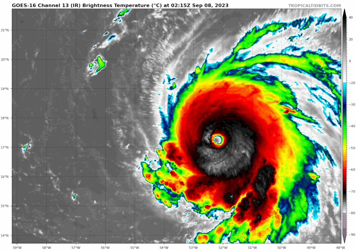
The eye seems to be cooling, but so does the CDO. So I dunno.
2 likes
TC naming lists: retirements and intensity
Most aggressive Advisory #1's in North Atlantic (cr. kevin for starting the list)
Most aggressive Advisory #1's in North Atlantic (cr. kevin for starting the list)
-
REDHurricane

- Category 1
- Posts: 438
- Age: 28
- Joined: Sun Jul 03, 2022 2:36 pm
- Location: Northeast Pacific Ocean
Re: ATL: LEE - Hurricane - Discussion
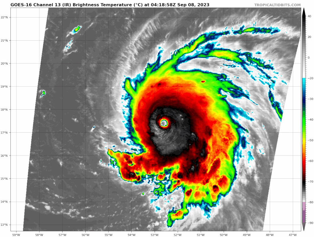
Looks like 25kt wind shear starting to cut right through the center as the upper level ridge shifts to the south -- maybe at least some slight weakening coming up soon?

0 likes
-
Meteorcane
- Category 2
- Posts: 559
- Joined: Thu Jul 21, 2011 6:49 am
- Location: North Platte Nebraska
Re: ATL: LEE - Hurricane - Discussion
REDHurricane wrote:Looks like 25kt wind shear starting to cut right through the center as the upper level ridge shifts to the south -- maybe at least some slight weakening coming up soon?
https://i.ibb.co/tQBpDc8/wg8shr.gif
Yeah looks like some modest weakening as the SWrly shear is clearly inhibiting the western extent of its convective envelop and outflow. We will see how long it lasts.
That being said I wouldn't be too surprised if it is able to overcome this shear better than we might expect though given how favorable the thermodynamic environment is. This will enable it to just continue reinforcing its warm core via efficient latent heat release in deep convection, and with outflow channels present in other quadrants it should still be able to vent somewhat. Now, as long as it is battling the enhanced shear it may keep it from getting to those truly remarkable 160+kt numbers and sub 910 pressures (which require near-perfect conditions), but it should be able to spend the majority of the next few days in the 130-150kt range.
Last edited by Meteorcane on Fri Sep 08, 2023 3:07 am, edited 1 time in total.
2 likes

Re: ATL: LEE - Hurricane - Discussion
Shear seems to be impacting Lee a bit. Still impressive, but might be back to 135 kt. Will probably strengthen again once shear relaxes which shouldn't take long.
0 likes
Re: ATL: LEE - Hurricane - Discussion
https://twitter.com/DrKimWood/status/1699950233692856339
https://twitter.com/DrKimWood/status/1699968947888779335
The second Tweet also has a comment chain with similar animations for Sam and Patricia.
https://twitter.com/DrKimWood/status/1699968947888779335
The second Tweet also has a comment chain with similar animations for Sam and Patricia.
3 likes
TC naming lists: retirements and intensity
Most aggressive Advisory #1's in North Atlantic (cr. kevin for starting the list)
Most aggressive Advisory #1's in North Atlantic (cr. kevin for starting the list)


Re: ATL: LEE - Hurricane - Discussion
The 5am advisory makes no mention of the shear. I wonder if it was written before shear became evident.
4 likes
TC naming lists: retirements and intensity
Most aggressive Advisory #1's in North Atlantic (cr. kevin for starting the list)
Most aggressive Advisory #1's in North Atlantic (cr. kevin for starting the list)
-
johngaltfla

- Category 5
- Posts: 2073
- Joined: Sun Jul 10, 2005 9:17 pm
- Location: Sarasota County, FL
- Contact:

Re: ATL: LEE - Hurricane - Discussion
Teban54 wrote:The 5am advisory makes no mention of the shear. I wonder if it was written before shear became evident.
Maybe they assumed it's a brief hiccup
0 likes
Re: ATL: LEE - Hurricane - Discussion
NOAA3 is on its way for tail doppler radar measurements. An AF plane should depart in 15 - 30 minutes for the next center fix and intensity passes.
1 likes
Re: ATL: LEE - Hurricane - Discussion
lee looking ragged on IR now. wonder if this trend continues.....
1 likes
Re: ATL: LEE - Hurricane - Discussion
https://twitter.com/zeb199818/status/1700076493043548575
Just posting this for the microwave, this guy seems to have a downcasting bias at least with Lee (as seen from his other tweets).
Just posting this for the microwave, this guy seems to have a downcasting bias at least with Lee (as seen from his other tweets).
0 likes
TC naming lists: retirements and intensity
Most aggressive Advisory #1's in North Atlantic (cr. kevin for starting the list)
Most aggressive Advisory #1's in North Atlantic (cr. kevin for starting the list)
Who is online
Users browsing this forum: No registered users and 13 guests