ATL: LEE - Models
Moderator: S2k Moderators
Re: ATL: LEE - Models
0Z EPS through 240: not as many hits on US as 12Z run but there still were 7: 6 on ME and 1 on NY. There may not be any more US hits after 240. Nova Scotia gets clobbered even more than on the 12Z. Newfoundland also gets some direct hits in addition to leftovers from some of the Nova Scotia hits.
1 likes
Personal Forecast Disclaimer:
The posts in this forum are NOT official forecasts and should not be used as such. They are just the opinion of the poster and may or may not be backed by sound meteorological data. They are NOT endorsed by any professional institution or storm2k.org. For official information, please refer to the NHC and NWS products.
The posts in this forum are NOT official forecasts and should not be used as such. They are just the opinion of the poster and may or may not be backed by sound meteorological data. They are NOT endorsed by any professional institution or storm2k.org. For official information, please refer to the NHC and NWS products.
-
RevanTheJedi96
- Tropical Storm

- Posts: 106
- Joined: Wed Sep 01, 2021 10:40 am
Re: ATL: LEE - Models
GFS shifted to the East again. With Lee weakening already, some great signs already in the works.
1 likes
-
PavelGaborik10
- Category 1

- Posts: 472
- Joined: Tue Sep 04, 2018 3:23 pm
Re: ATL: LEE - Models
RevanTheJedi96 wrote:GFS shifted to the East again. With Lee weakening already, some great signs already in the works.
The 06z literally landfalls slightly W of the 0z and is the polar opposite of the million mile shifting Euro.
3 likes
Re: ATL: LEE - Models
PavelGaborik10 wrote:RevanTheJedi96 wrote:GFS shifted to the East again. With Lee weakening already, some great signs already in the works.
The 06z literally landfalls slightly W of the 0z and is the polar opposite of the million mile shifting Euro.
It seems clear that the interaction with Margot is the key here. Euro has them close and that pulls Lee out to see - but also the models dont really do well with these interaction scenarios. GFS has them far enough part that they dont really interact, so it landfalls, and Margot continues on to pull Nigel up to the central Atlantic instead of allowing it to move into a similar position as Lee is now.
1 likes
-
rickcorvin
- Tropical Low

- Posts: 10
- Joined: Wed Jun 03, 2020 7:12 am
Re: ATL: LEE - Models
SouthFLTropics wrote:AxaltaRacing24 wrote:SouthFLTropics wrote:The spread on the 00z GEFS has gotten considerably larger at hour 168. So much so that perhaps even South Carolina is in play. We’ve got a long way to go with this one.
Sent from my iPhone using Tapatalk
The general rule always used to be that wherever the landfall is 6-10+ days out, that’s usually not where it’s going. So those kind of shifts would not shock me.
Yeah, that was, and possibly still is the rule. The best place to be 6 to 10 days out is right in the bullseye. We still have much to learn about a science that is constantly in motion. Can anyone say chaos theory.
Sent from my iPhone using Tapatalk
I agree with the larger point about forecast uncertainty 6-10 days out, particularly with models. But we only need to look back a couple of weeks to see a storm (Idalia) that made landfall near the long range NHC track.
3 likes
Re: ATL: LEE - Models
Teban54 wrote:0z hurricane models. All of them show Lee achieving a first peak within 6 hours from now, but the two HAFS models show a secondary peak in 1.5-2 days (after an EWRC) with even lower pressure.
HAFS-A:HAFS-B:
- Init: 941.0 mb, 148.9 kt
- 6z (now): 920.1 mb, 161.9 kt (First peak)
- Second peak: 18z 9/9 (42 hrs), 910.3 mb, 157.0 kt
HWRF:
- Init: 939.5 mb, 132.7 kt
- 6z (now): 929.5 mb, 144.7 kt
- First peak: 12z 9.8 (12 hrs), 919.5 mb, 160.6 kt
- Second peak: 6z 9/10 (54 hrs), 912.7 mb, 154.4 kt
HMON:
- Init: 933.8 mb, 150.4 kt
- 6z (now): 926.7 mb, 137.0 kt
- First and only peak: 12z 9.8 (12 hrs), 922.4 mb, 140.2 kt
- Init: 932.5 mb, 123.1 kt
- 6z (now): 916.3 mb, 147.5 kt
- First peak: 9z 9.8 (9 hrs), 916.2 mb, 147.9 kt
- Second peak: 21z 9/10 (69 hrs), 928.0 mb, 131.8 kt
Thanks man, this is a great overview.
Please consider doing it again at 12Z to see how it compares
1 likes
-
SouthFLTropics

- Category 5

- Posts: 4258
- Age: 50
- Joined: Thu Aug 14, 2003 8:04 am
- Location: Port St. Lucie, Florida
Re: ATL: LEE - Models
rickcorvin wrote:SouthFLTropics wrote:AxaltaRacing24 wrote:The general rule always used to be that wherever the landfall is 6-10+ days out, that’s usually not where it’s going. So those kind of shifts would not shock me.
Yeah, that was, and possibly still is the rule. The best place to be 6 to 10 days out is right in the bullseye. We still have much to learn about a science that is constantly in motion. Can anyone say chaos theory.
Sent from my iPhone using Tapatalk
I agree with the larger point about forecast uncertainty 6-10 days out, particularly with models. But we only need to look back a couple of weeks to see a storm (Idalia) that made landfall near the long range NHC track.
I can't argue with that point. The NHC has gotten damn good at doing their job over the years.
3 likes
Fourth Generation Florida Native
Personal Storm History: David 79, Andrew 92, Erin 95, Floyd 99, Irene 99, Frances 04, Jeanne 04, Wilma 05, Matthew 16, Irma 17, Ian 22, Nicole 22, Milton 24
Personal Storm History: David 79, Andrew 92, Erin 95, Floyd 99, Irene 99, Frances 04, Jeanne 04, Wilma 05, Matthew 16, Irma 17, Ian 22, Nicole 22, Milton 24
-
tolakram
- Admin

- Posts: 20176
- Age: 62
- Joined: Sun Aug 27, 2006 8:23 pm
- Location: Florence, KY (name is Mark)
Re: ATL: LEE - Models
PavelGaborik10 wrote:RevanTheJedi96 wrote:AxaltaRacing24 wrote:These runs are getting really goofy at the end I cannot lie.
I like the end result of these runs if it keeps Lee off the East Coast!
Sure, but I csnt stand it from a forecasting standpoint.
This is downright embarrassing in 2023.
You're using the long term modelling wrong. Past 5 days accuracy falls off a cliff, the amount of raw data needed to predict that far out is bigger than huge. One small error, and there are many due to not sampling 100% of the atmosphere every second, just keeps compounding the further out it goes. Regardless of the quality of the model there is simply no way to be super accurate past 5 days. Then add to the fact that the further north you get the less data is available ... good luck!
8 likes
M a r k
- - - - -
Join us in chat: Storm2K Chatroom Invite. Android and IOS apps also available.
The posts in this forum are NOT official forecasts and should not be used as such. Posts are NOT endorsed by any professional institution or STORM2K.org. For official information and forecasts, please refer to NHC and NWS products.

Re: ATL: LEE - Models
rickcorvin wrote:SouthFLTropics wrote:AxaltaRacing24 wrote: But we only need to look back a couple of weeks to see a storm (Idalia) that made landfall near the long range NHC track.
That was a remarkably accurate prediction especially given a storm that was virtually stationary at the time.
3 likes
I'm not a meteorologist, I'm an electronics engineer. While I can probably fix your toaster oven, you're not going to learn about storms from me!
New Mexico had no hurricanes. Then I moved to NC right before Fran.....
New Mexico had no hurricanes. Then I moved to NC right before Fran.....
-
wxman57

- Moderator-Pro Met

- Posts: 23171
- Age: 68
- Joined: Sat Jun 21, 2003 8:06 pm
- Location: Houston, TX (southwest)
Re: ATL: LEE - Models
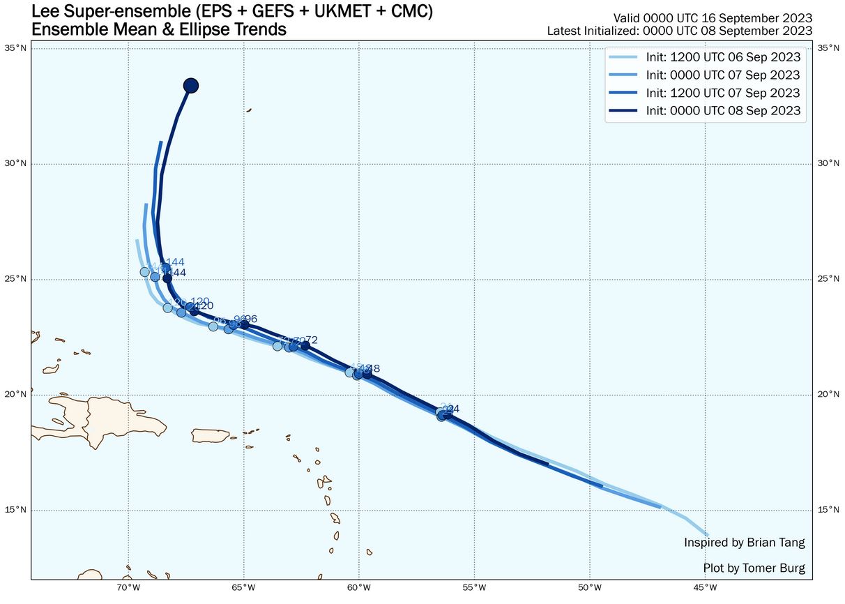
This Univ. of OK PhD student, Tomer Burg, has some excellent data on his site. http://arctic.som.ou.edu/tburg/products/realtime/tropical/?storm=AL132023
Here's a plot of all members of the GFS, EC, CMC, and UKMET ensembles. Plot identifies the chances of the center passing within 150km of a location:

Same plot, but with the operational and ensemble mean lines:

Here's a plot showing a trend of the ensembles for the past 4 runs. Clearly, the trend is farther east of the U.S.
Here's a plot of all members of the GFS, EC, CMC, and UKMET ensembles. Plot identifies the chances of the center passing within 150km of a location:
Same plot, but with the operational and ensemble mean lines:
Here's a plot showing a trend of the ensembles for the past 4 runs. Clearly, the trend is farther east of the U.S.
2 likes
-
cycloneye

- Admin
- Posts: 149220
- Age: 69
- Joined: Thu Oct 10, 2002 10:54 am
- Location: San Juan, Puerto Rico
Re: ATL: LEE - Models
1 likes
Visit the Caribbean-Central America Weather Thread where you can find at first post web cams,radars
and observations from Caribbean basin members Click Here
and observations from Caribbean basin members Click Here
-
invest man
- Tropical Storm
- Posts: 209
- Joined: Sun Aug 17, 2008 8:12 pm
Re: ATL: LEE - Models
cycloneye wrote:https://twitter.com/DerekOrtt/status/1700118073573794009
Question. So then can these models be considered useful for the track? Or should we consider anything passed the NHC forecast of no use for anything other than wishful thinking or entertainment purposes and say again the whole east coast is not safe until it is safe? Along with the slow down, is it possible for it to get trapped south of Hatteras- Bermuda to east of Bahamas way longer than the 6+ day tracks are showing?
1 likes
-
REDHurricane

- Category 1
- Posts: 438
- Age: 28
- Joined: Sun Jul 03, 2022 2:36 pm
- Location: Northeast Pacific Ocean
Re: ATL: LEE - Models
invest man wrote:cycloneye wrote:https://twitter.com/DerekOrtt/status/1700118073573794009
Question. So then can these models be considered useful for the track? Or should we consider anything passed the NHC forecast of no use for anything other than wishful thinking or entertainment purposes and say again the whole east coast is not safe until it is safe? Along with the slow down, is it possible for it to get trapped south of Hatteras- Bermuda to east of Bahamas way longer than the 6+ day tracks are showing?
At this point I wouldn't say that anything is impossible. Something about this setup really seems to be confusing all of the models, so no one actually knows where this storm will end up going 7+ days in the future with any certainty
0 likes
-
TomballEd
- Category 5
- Posts: 1258
- Age: 62
- Joined: Wed Aug 16, 2023 4:52 pm
- Location: Spring/Klein area, not Tomball
Re: ATL: LEE - Models
The models seem to generally do well, sometimes 50 miles wrong, so that someone doesn't get their sensible weather and cries 'bust', within a few days of a NE USA snowstorm. I lived near NYC long enough my wife knew the KU monographs was a great birthday present. NE snowstorms can pump the downstream ridge and increase amplitude and decrease wavelength. Within a few days the 'bust' can be 50 miles, if it moves the R/S line to the 'wrong' side of a big city.
I understand understanding how strong a storm is essential to understanding how it might change the steering around it, but I'd be surprise if Lee hits CONUS anywhere except near Canada border Maine.
Tropical Tidbits recon map suggests weaker winds in a small moat-ish feature, or there is a big max eyewall, a small min, and another relative maximum. Or I think the higher pressure this morning may be an EWRC.
1 likes
-
rickcorvin
- Tropical Low
- Posts: 10
- Joined: Wed Jun 03, 2020 7:12 am
Re: ATL: LEE - Models
invest man wrote:cycloneye wrote:https://twitter.com/DerekOrtt/status/1700118073573794009
Question. So then can these models be considered useful for the track? Or should we consider anything passed the NHC forecast of no use for anything other than wishful thinking or entertainment purposes and say again the whole east coast is not safe until it is safe? Along with the slow down, is it possible for it to get trapped south of Hatteras- Bermuda to east of Bahamas way longer than the 6+ day tracks are showing?
Keep in mind that Derek Ortt regularly trashes the model forecasts, particularly the GFS. He does it for every storm. Models are useful tools, but not perfect. Look to the NHC and ensembles 5+ days out.
1 likes
-
Hybridstorm_November2001

- S2K Supporter

- Posts: 2817
- Joined: Sat Aug 21, 2004 2:50 pm
- Location: SW New Brunswick, Canada
- Contact:
Re: ATL: LEE - Models
Hmmm, curiouser and curiouser, overnight/early this morning the GFS runs had Lee arriving in Nova Scotia on Friday, September 15th while Euro runs had Lee arriving or going just south of Nova Scotia an entire day later Saturday, September 16th. Still a great deal of uncertainty here.
0 likes
-
Hybridstorm_November2001
- S2K Supporter
- Posts: 2817
- Joined: Sat Aug 21, 2004 2:50 pm
- Location: SW New Brunswick, Canada
- Contact:
Re: ATL: LEE - Models
tomatkins wrote:PavelGaborik10 wrote:RevanTheJedi96 wrote:GFS shifted to the East again. With Lee weakening already, some great signs already in the works.
The 06z literally landfalls slightly W of the 0z and is the polar opposite of the million mile shifting Euro.
It seems clear that the interaction with Margot is the key here. Euro has them close and that pulls Lee out to see - but also the models dont really do well with these interaction scenarios. GFS has them far enough part that they dont really interact, so it landfalls, and Margot continues on to pull Nigel up to the central Atlantic instead of allowing it to move into a similar position as Lee is now.
Indeed, the Margot-Lee interaction may save any mainland area from a direct hit, here is hoping.

0 likes
-
PavelGaborik10
- Category 1
- Posts: 472
- Joined: Tue Sep 04, 2018 3:23 pm
Re: ATL: LEE - Models
tolakram wrote:PavelGaborik10 wrote:RevanTheJedi96 wrote:
I like the end result of these runs if it keeps Lee off the East Coast!
Sure, but I csnt stand it from a forecasting standpoint.
This is downright embarrassing in 2023.
You're using the long term modelling wrong. Past 5 days accuracy falls off a cliff, the amount of raw data needed to predict that far out is bigger than huge. One small error, and there are many due to not sampling 100% of the atmosphere every second, just keeps compounding the further out it goes. Regardless of the quality of the model there is simply no way to be super accurate past 5 days. Then add to the fact that the further north you get the less data is available ... good luck!
I'd concur IF this was a regular mishap, which we typically see in the long range
What we do not typically see is storms shift thousands upon thousands of miles in the span of a single run, be it 7 days or not. There are plenty of well respected mets on social media who concur with me as well, Derek in particular blames the current resolution of the Euro and deems the Euro leaping Margot across the entire Atlantic in the span of an entire run completely and totally unacceptable.
I'm not looking for anywhere near perfection but even a slight amount of consistency would be nice.
I'm in agreement with him, it's horrendous modeling :
https://twitter.com/DerekOrtt/status/1700038744122819029
https://twitter.com/DerekOrtt/status/1700040196165718309
https://twitter.com/DerekOrtt/status/1700041220137885939
The only way to "properly" utilize long range modeling that's this poor is to throw it in the garbage :
[url]blob:https://www.tropicaltidbits.com/354a6a8f-fd17-464e-885c-4ed429b29455[/url]
And it starts with its complete and utter failure with Margot in the short to medium range, that's what leads to this mess.
2 likes
-
Spacecoast

- Category 2

- Posts: 773
- Joined: Thu Aug 31, 2017 2:03 pm
Re: ATL: LEE - Models
Perhaps Derek can plot a 10day forecast for Lee, and subject himself to actual verification.
4 likes
Who is online
Users browsing this forum: No registered users and 11 guests