AL, 13, 2023090900, , BEST, 0, 190N, 560W, 105, 958, HU, 64, NEQ, 25, 25, 15, 25, 1011, 150, 10, 0, 0, L, 0, , 0, 0, LEE, D, 0, , 0, 0, 0, 0, genesis-num, 027,
ATL: LEE - Post-Tropical - Discussion
Moderator: S2k Moderators
-
WalterWhite

- Category 1

- Posts: 342
- Joined: Fri Mar 17, 2023 5:53 pm
Re: ATL: LEE - Hurricane - Discussion - Weakened to 105 kt based on BTK data
Lee has weakened to 105 knots.
1 likes
-
ElectricStorm

- Category 5

- Posts: 5141
- Age: 25
- Joined: Tue Aug 13, 2019 11:23 pm
- Location: Norman, OK
Re: ATL: LEE - Hurricane - Discussion
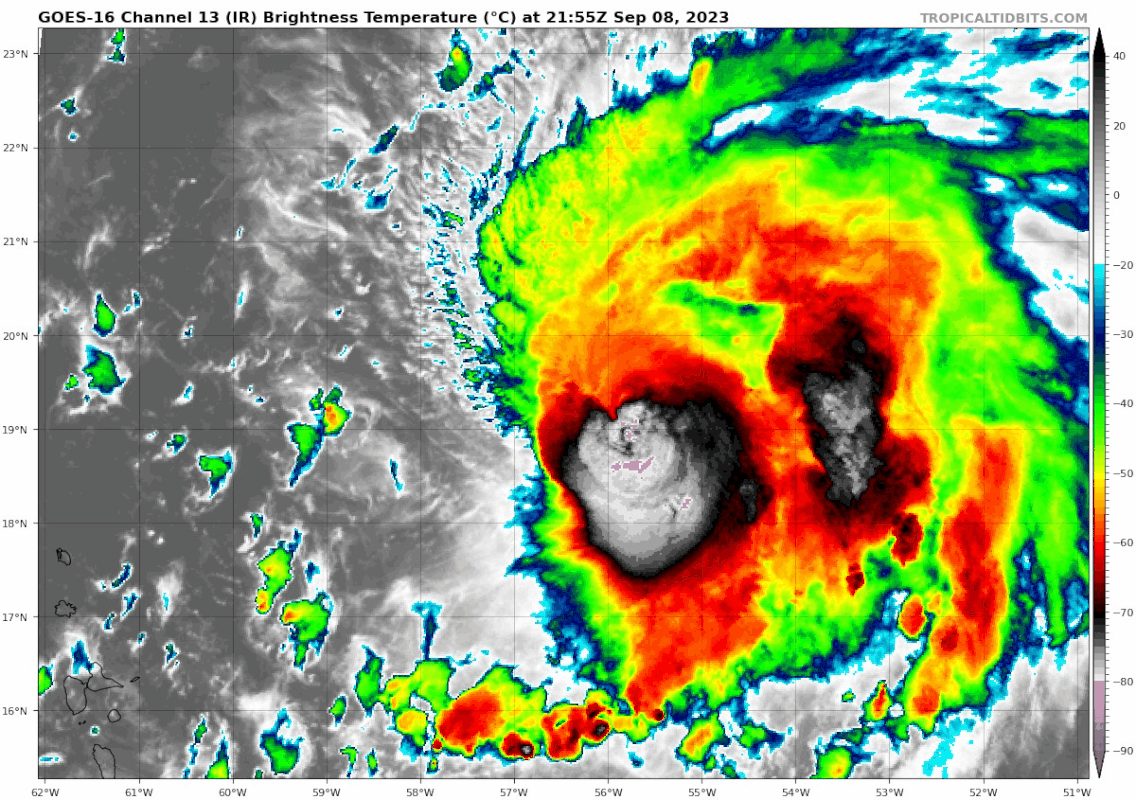
Some dry air in the N eyewall

0 likes
B.S Meteorology, University of Oklahoma '25
Please refer to the NHC, NWS, or SPC for official information.
Please refer to the NHC, NWS, or SPC for official information.
-
cycloneye

- Admin

- Posts: 149283
- Age: 69
- Joined: Thu Oct 10, 2002 10:54 am
- Location: San Juan, Puerto Rico
Re: ATL: LEE - Hurricane - Discussion
TXNT22 KNES 090026
TCSNTL
A. 13L (LEE)
B. 09/0000Z
C. 19.5N
D. 56.4W
E. ONE/GOES-E
F. T5.5/6.5
G. IR/EIR/SWIR
H. REMARKS...SYSTEM CHARACTERIZED BY A MG EYE SURROUNDED BY LG AND
EMBEDDED IN MG FOR A DT=4.0 MET=5.0 PT=4.5. THE FT IS BASED ON THE
CONSTRAINTS LIMITING CHANGE OVER 6HRS.
I. ADDL POSITIONS
NIL
...FISHER
TCSNTL
A. 13L (LEE)
B. 09/0000Z
C. 19.5N
D. 56.4W
E. ONE/GOES-E
F. T5.5/6.5
G. IR/EIR/SWIR
H. REMARKS...SYSTEM CHARACTERIZED BY A MG EYE SURROUNDED BY LG AND
EMBEDDED IN MG FOR A DT=4.0 MET=5.0 PT=4.5. THE FT IS BASED ON THE
CONSTRAINTS LIMITING CHANGE OVER 6HRS.
I. ADDL POSITIONS
NIL
...FISHER
0 likes
Visit the Caribbean-Central America Weather Thread where you can find at first post web cams,radars
and observations from Caribbean basin members Click Here
and observations from Caribbean basin members Click Here
-
ElectricStorm
- Category 5
- Posts: 5141
- Age: 25
- Joined: Tue Aug 13, 2019 11:23 pm
- Location: Norman, OK
Re: ATL: LEE - Hurricane - Discussion
Very weak NW quad and extrap pressure is up to 961.5mb
0 likes
B.S Meteorology, University of Oklahoma '25
Please refer to the NHC, NWS, or SPC for official information.
Please refer to the NHC, NWS, or SPC for official information.
Re: ATL: LEE - Hurricane - Discussion
ElectricStorm wrote:Some dry air in the N eyewall
https://i.imgur.com/0cWVHNl.png
The relative humidity is 85% at 850mb, 100% at 925mb, and 97% at surface. What is giving you the impression of dry air?
I don't mean that to come off rude either, I'm asking because this also happened during Idalia's recon.
0 likes
Solar Aquarian
Lunar Cancerian
 Sagittarian
Lunar Cancerian

Re: ATL: LEE - Hurricane - Discussion
Could the shear be getting weaker? While still messy, CDO now looks a bit more symmetrical, especially the western half
0 likes
-
ElectricStorm
- Category 5
- Posts: 5141
- Age: 25
- Joined: Tue Aug 13, 2019 11:23 pm
- Location: Norman, OK
Re: ATL: LEE - Hurricane - Discussion
Chris90 wrote:ElectricStorm wrote:Some dry air in the N eyewall
https://i.imgur.com/0cWVHNl.png
The relative humidity is 85% at 850mb, 100% at 925mb, and 97% at surface. What is giving you the impression of dry air?
I don't mean that to come off rude either, I'm asking because this also happened during Idalia's recon.
85% seems a little low for an eyewall, most eyewall drops I've seen tend to be very saturated but I could be wrong. It also seems to match up with the dry air near the northern eyewall on IR
1 likes
B.S Meteorology, University of Oklahoma '25
Please refer to the NHC, NWS, or SPC for official information.
Please refer to the NHC, NWS, or SPC for official information.
-
PavelGaborik10
- Category 1
- Posts: 472
- Joined: Tue Sep 04, 2018 3:23 pm
Re: ATL: LEE - Hurricane - Discussion
ElectricStorm wrote:PavelGaborik10 wrote:galaxy401 wrote:
By having doubts do you mean that it could keep weakening until Tropical Storm or will it even restrengthen? Feel like that phrase is vague.
I'm having doubts that we see Lee reintensify into a strong category 4/category 5 again as some of the hurricane models are showing.
I think it's likely a category 2 at the moment based on the recon data I've seen as well.
I mean both HAFS models weaken it to a lower end Cat 1 and they both get back to Cat 5 in a few days. I wouldn't necessarily bet on another Cat 5 peak but assuming shear lessens in around 24 hours or so it will still have a few days to re-intensify
Sure, but they also had Lee nearing an intensity of 200 MPH today, and it's currently a borderline 3 at best.
I do anticipate it will reorganize, but I'm not banking on the cat 5 intensity forecasts to verify either.
Time will tell.
3 likes
-
Hurricane2022

- Category 5
- Posts: 2016
- Joined: Tue Aug 23, 2022 11:38 pm
- Location: Araçatuba, Brazil
Re: ATL: LEE - Hurricane - Discussion
1 likes
Sorry for the bad English sometimes...!
For reliable and detailed information for any meteorological phenomenon, please consult the National Hurricane Center, Joint Typhoon Warning Center , or your local Meteo Center.
--------
ECCE OMNIA NOVA FACIAM (Ap 21,5).
For reliable and detailed information for any meteorological phenomenon, please consult the National Hurricane Center, Joint Typhoon Warning Center , or your local Meteo Center.
--------
ECCE OMNIA NOVA FACIAM (Ap 21,5).
-
GeneralChow
- Tropical Low

- Posts: 12
- Joined: Thu Sep 07, 2023 9:11 pm
- Location: Ft Lauderdale, FL
Re: ATL: LEE - Hurricane - Discussion
Chris90 wrote:ElectricStorm wrote:Some dry air in the N eyewall
https://i.imgur.com/0cWVHNl.png
The relative humidity is 85% at 850mb, 100% at 925mb, and 97% at surface. What is giving you the impression of dry air?
I don't mean that to come off rude either, I'm asking because this also happened during Idalia's recon.
Have you checked out the recon data from the southern side of the storm. That convection to the south is pretty dry.
https://www.tropicaltidbits.com/sat/sat ... uct=wv_rgb
The Relative Humidity with the 700Mb Level is 50%, particularly on the NW side of the system. There are readings of 40-60% around the convective ball, and you can see the sparse rainfall reports from the passes over the southern side. In fact, the pressure falls are a lot flatter on the souther side, which I believe would indicate subsidence.
http://tropicalatlantic.com/recon/recon ... 968-125-81
0 likes
Re: ATL: LEE - Hurricane - Discussion
ElectricStorm wrote:Chris90 wrote:ElectricStorm wrote:Some dry air in the N eyewall
https://i.imgur.com/0cWVHNl.png
The relative humidity is 85% at 850mb, 100% at 925mb, and 97% at surface. What is giving you the impression of dry air?
I don't mean that to come off rude either, I'm asking because this also happened during Idalia's recon.
85% seems a little low for an eyewall, most eyewall drops I've seen tend to be very saturated but I could be wrong. It also seems to match up with the dry air near the northern eyewall on IR
Ahh ok, gotcha. I just wasn't giving too much weight to the 85% without other values being less than 90% too, it seemed to me to be a less moist blip compared to the rest of the column but not detrimental. I also could be very wrong, I'm not quite sure when humidity values start to be detrimental instead of neutral, that's why I was wondering.
0 likes
Solar Aquarian
Lunar Cancerian
Sagittarian
Lunar Cancerian
-
Sciencerocks
- Category 5
- Posts: 10181
- Age: 40
- Joined: Thu Jul 06, 2017 1:51 am

-
TheDreamTraveler

- Category 2

- Posts: 645
- Joined: Sun Aug 22, 2010 3:10 am
- Location: PA
Re: ATL: LEE - Hurricane - Discussion
For people doubting if Lee can regain some of its strength it definitely can. Remember when Florence reached category 4 strength then weakened to a tropical storm and then restrengthened back to a category 4? I just don't think Lee will be anywhere near its former strength but it will probably get a bit stronger than it currently is again once it's in more optimal conditions
4 likes
-
Tekken_Guy
- Tropical Storm

- Posts: 150
- Joined: Fri Sep 01, 2017 8:08 pm
Re: ATL: LEE - Hurricane - Discussion
TheDreamTraveler wrote:For people doubting if Lee can regain some of its strength it definitely can. Remember when Florence reached category 4 strength then weakened to a tropical storm and then restrengthened back to a category 4? I just don't think Lee will be anywhere near its former strength but it will probably get a bit stronger than it currently is again once it's in more optimal conditions
Is there any reason to doubt Lee will regain Category 5 status in the future?
0 likes
Re: ATL: LEE - Hurricane - Discussion
TheDreamTraveler wrote:For people doubting if Lee can regain some of its strength it definitely can. Remember when Florence reached category 4 strength then weakened to a tropical storm and then restrengthened back to a category 4? I just don't think Lee will be anywhere near its former strength but it will probably get a bit stronger than it currently is again once it's in more optimal conditions
It's hard to tell in that IR shot but it looked like the western side of the storm was building back and it was a bit more symmetrical.
0 likes


Re: ATL: LEE - Hurricane - Discussion
Looks like some deep convection is re-firing and the sheared look is fading out. He's likely on way to re-strengthening. Most models have a larger eye-like storm (think Franklin) with the next regrouping phase. Not sure if it will go back to cat 5 but cat 4 seems doable.
0 likes
The above post and any post by Ntxw is NOT an official forecast and should not be used as such. It is just the opinion of the poster and may or may not be backed by sound meteorological data. It is NOT endorsed by any professional institution including Storm2k. For official information, please refer to NWS products.
Help support Storm2K!


Re: ATL: LEE - Hurricane - Discussion
TheDreamTraveler wrote:For people doubting if Lee can regain some of its strength it definitely can. Remember when Florence reached category 4 strength then weakened to a tropical storm and then restrengthened back to a category 4? I just don't think Lee will be anywhere near its former strength but it will probably get a bit stronger than it currently is again once it's in more optimal conditions
This also happened with Sam. Went from a 135 kt Cat 4 (many people believing it was a Cat 5) to a Cat 3 almost Cat 2 due to an EWRC and some shear, then reintensified to a third peak that yet again looked like Cat 5 was plausible.
1 likes
TC naming lists: retirements and intensity
Most aggressive Advisory #1's in North Atlantic (cr. kevin for starting the list)
Most aggressive Advisory #1's in North Atlantic (cr. kevin for starting the list)
-
floridasun
- Tropical Storm
- Posts: 245
- Joined: Tue Sep 14, 2021 3:59 pm
Re: ATL: LEE - Hurricane - Discussion
Satellite presentation is improving with a rounder W CDO. Might start intensifying again soon if shear remains low enough
0 likes
Re: ATL: LEE - Hurricane - Discussion
Over the course of this IR loop, you can see the CDO becoming more symmetrical and expanding to the SW, where it had been restricted since the shear hit Lee yesterday. Not sure if it's shear letting up or simply changing direction, but either way, I won't be surprised if it drops sooner than NHC noted in the advisory (24 hours).
3 likes
TC naming lists: retirements and intensity
Most aggressive Advisory #1's in North Atlantic (cr. kevin for starting the list)
Most aggressive Advisory #1's in North Atlantic (cr. kevin for starting the list)
Who is online
Users browsing this forum: No registered users and 26 guests