ATL: LEE - Post-Tropical - Discussion
Moderator: S2k Moderators
-
Iceresistance

- Category 5

- Posts: 9579
- Age: 22
- Joined: Sat Oct 10, 2020 9:45 am
- Location: Tecumseh, OK/Norman, OK
Re: ATL: LEE - Hurricane - Discussion
The Anti Cyclone that dissipated yesterday has returned south of Lee
0 likes
Bill 2015 & Beta 2020
Winter 2020-2021
All observations are in Tecumseh, OK unless otherwise noted.
Winter posts are focused mainly for Oklahoma & Texas.
Take any of my forecasts with a grain of salt, refer to the NWS, SPC, and NHC for official information
Never say Never with weather! Because ANYTHING is possible!
Winter 2020-2021
All observations are in Tecumseh, OK unless otherwise noted.
Winter posts are focused mainly for Oklahoma & Texas.
Take any of my forecasts with a grain of salt, refer to the NWS, SPC, and NHC for official information
Never say Never with weather! Because ANYTHING is possible!

Re: ATL: LEE - Hurricane - Discussion
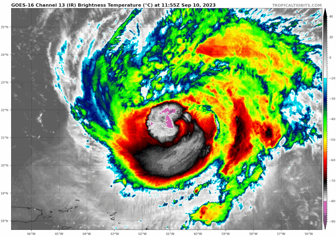
Convection has almost finished wrapping around the eye.
1 likes
TC naming lists: retirements and intensity
Most aggressive Advisory #1's in North Atlantic (cr. kevin for starting the list)
Most aggressive Advisory #1's in North Atlantic (cr. kevin for starting the list)


Re: ATL: LEE - Hurricane - Discussion
Looks like St Kitts to Monserrat, eastward to Barbuda and Antigua are getting some repetitious refreshing squalls training over them from the southwest as as result of Lee's weak outer band. That distant impact is probably nuisance enough to whip around patio umbrellas or small porch items where exposed or somewhat elevated.
0 likes
Andy D
(For official information, please refer to the NHC and NWS products.)
(For official information, please refer to the NHC and NWS products.)


Re: ATL: LEE - Hurricane - Discussion
Teban54 wrote:Convection has almost finished wrapping around the eye.
https://i.postimg.cc/9MMny9HN/goes16-ir-13-L-202309101155.gif
Looking particularly good in the last frames
0 likes
-
Sciencerocks
- Category 5
- Posts: 10181
- Age: 40
- Joined: Thu Jul 06, 2017 1:51 am

Re: ATL: LEE - Hurricane - Discussion
Wow, nothin' like a little bit of northward motion to help mitigate that southerly shear!
On a bit of a side note..... I've got a question for any MET. I swear that Lee's outflow clearly appears to be at a lower elevation then a good deal of its primary core counterclockwise circulation. Both the northern quadrant where outflow appears to be expanding and flowing outward, as well as in the southern quadrant where outflow has been limited. If my observation is correct, then that just doesn't make any rational sense to me. From how I am observing it, the outflow which should be spewing out roughly around the 200 mb level, is occurring a good deal lower in elevation (300-500mb?). That just wouldn't make any sense but if so, am struggling to understand a cause. Anomalous lower height/elevation cool sinking air? A reflection of anomalous dry air at or above 300mb? It's clear from Lee's cold tops that convection is exploding through that layer but is having a battle maintaining more than a relatively small inner core depicting those cloud temps.
On a bit of a side note..... I've got a question for any MET. I swear that Lee's outflow clearly appears to be at a lower elevation then a good deal of its primary core counterclockwise circulation. Both the northern quadrant where outflow appears to be expanding and flowing outward, as well as in the southern quadrant where outflow has been limited. If my observation is correct, then that just doesn't make any rational sense to me. From how I am observing it, the outflow which should be spewing out roughly around the 200 mb level, is occurring a good deal lower in elevation (300-500mb?). That just wouldn't make any sense but if so, am struggling to understand a cause. Anomalous lower height/elevation cool sinking air? A reflection of anomalous dry air at or above 300mb? It's clear from Lee's cold tops that convection is exploding through that layer but is having a battle maintaining more than a relatively small inner core depicting those cloud temps.
0 likes
Andy D
(For official information, please refer to the NHC and NWS products.)
(For official information, please refer to the NHC and NWS products.)
-
WalterWhite

- Category 1

- Posts: 342
- Joined: Fri Mar 17, 2023 5:53 pm
-
Iceresistance
- Category 5
- Posts: 9579
- Age: 22
- Joined: Sat Oct 10, 2020 9:45 am
- Location: Tecumseh, OK/Norman, OK
Re: ATL: LEE - Hurricane - Discussion
WalterWhite wrote:Sciencerocks wrote:https://imagizer.imageshack.com/img924/2513/WMxV2W.gif
I see multiple eyewalls.
Recon does not show any well-defined multiple double wind maximas.

https://s11.gifyu.com/images/S4pIT.png
The eyewall appears to be thicker. Drop #3 is the SW Eyewall and Drop #4 is the eye

https://s11.gifyu.com/images/S4p7y.png
3 likes
Bill 2015 & Beta 2020
Winter 2020-2021
All observations are in Tecumseh, OK unless otherwise noted.
Winter posts are focused mainly for Oklahoma & Texas.
Take any of my forecasts with a grain of salt, refer to the NWS, SPC, and NHC for official information
Never say Never with weather! Because ANYTHING is possible!
Winter 2020-2021
All observations are in Tecumseh, OK unless otherwise noted.
Winter posts are focused mainly for Oklahoma & Texas.
Take any of my forecasts with a grain of salt, refer to the NWS, SPC, and NHC for official information
Never say Never with weather! Because ANYTHING is possible!
-
cycloneye

- Admin

- Posts: 149276
- Age: 69
- Joined: Thu Oct 10, 2002 10:54 am
- Location: San Juan, Puerto Rico
Re: ATL: LEE - Hurricane - Discussion
Drop was at 960 mbs.

0 likes
Visit the Caribbean-Central America Weather Thread where you can find at first post web cams,radars
and observations from Caribbean basin members Click Here
and observations from Caribbean basin members Click Here
-
Iceresistance
- Category 5
- Posts: 9579
- Age: 22
- Joined: Sat Oct 10, 2020 9:45 am
- Location: Tecumseh, OK/Norman, OK
Re: ATL: LEE - Hurricane - Discussion

1 likes
Bill 2015 & Beta 2020
Winter 2020-2021
All observations are in Tecumseh, OK unless otherwise noted.
Winter posts are focused mainly for Oklahoma & Texas.
Take any of my forecasts with a grain of salt, refer to the NWS, SPC, and NHC for official information
Never say Never with weather! Because ANYTHING is possible!
Winter 2020-2021
All observations are in Tecumseh, OK unless otherwise noted.
Winter posts are focused mainly for Oklahoma & Texas.
Take any of my forecasts with a grain of salt, refer to the NWS, SPC, and NHC for official information
Never say Never with weather! Because ANYTHING is possible!

Re: ATL: LEE - Hurricane - Discussion
Eye is a little big but it’ll likely contract if Lee keeps intensifying. The eye drop shows a fully saturated eye from 956-850 mb, so an EWRC doesn’t seem imminent, even though visible imagery suggests there’s a lot of banding. Pressure has remained pretty constant today. Let’s see if Lee’s improved structure ends up resulting in intensification by tonight.
0 likes
Irene '11 Sandy '12 Hermine '16 5/15/2018 Derecho Fay '20 Isaias '20 Elsa '21 Henri '21 Ida '21
I am only a meteorology enthusiast who knows a decent amount about tropical cyclones. Look to the professional mets, the NHC, or your local weather office for the best information.
I am only a meteorology enthusiast who knows a decent amount about tropical cyclones. Look to the professional mets, the NHC, or your local weather office for the best information.
-
IsabelaWeather
- Category 1
- Posts: 316
- Age: 36
- Joined: Tue Jul 07, 2020 7:29 am
- Location: Isabela, Puerto Rico
Re: ATL: LEE - Hurricane - Discussion
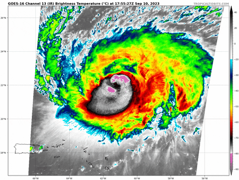
Really looks to be ramping up right now. Almost have a closed ring of <80* showing up
2 likes
-
cycloneye
- Admin
- Posts: 149276
- Age: 69
- Joined: Thu Oct 10, 2002 10:54 am
- Location: San Juan, Puerto Rico
Re: ATL: LEE - Hurricane - Discussion
Breaking news: Back up to cat 3 at 18z Best Track:
AL, 13, 2023091018, , BEST, 0, 219N, 614W, 100, 956, HU
2 likes
Visit the Caribbean-Central America Weather Thread where you can find at first post web cams,radars
and observations from Caribbean basin members Click Here
and observations from Caribbean basin members Click Here
-
SpinnerLover
- Tropical Wave

- Posts: 7
- Joined: Sat Aug 26, 2023 11:48 am

-
REDHurricane

- Category 1
- Posts: 438
- Age: 28
- Joined: Sun Jul 03, 2022 2:36 pm
- Location: Northeast Pacific Ocean
-
Iceresistance
- Category 5
- Posts: 9579
- Age: 22
- Joined: Sat Oct 10, 2020 9:45 am
- Location: Tecumseh, OK/Norman, OK
Re: ATL: LEE - Hurricane - Discussion: 18z Best Track up to cat 3 100 kt
Curses! No signal from AF306!
0 likes
Bill 2015 & Beta 2020
Winter 2020-2021
All observations are in Tecumseh, OK unless otherwise noted.
Winter posts are focused mainly for Oklahoma & Texas.
Take any of my forecasts with a grain of salt, refer to the NWS, SPC, and NHC for official information
Never say Never with weather! Because ANYTHING is possible!
Winter 2020-2021
All observations are in Tecumseh, OK unless otherwise noted.
Winter posts are focused mainly for Oklahoma & Texas.
Take any of my forecasts with a grain of salt, refer to the NWS, SPC, and NHC for official information
Never say Never with weather! Because ANYTHING is possible!
-
WalterWhite
- Category 1
- Posts: 342
- Joined: Fri Mar 17, 2023 5:53 pm
Re: ATL: LEE - Hurricane - Discussion: 18z Best Track up to cat 3 100 kt
cycloneye wrote:Breaking news: Back up to cat 3 at 18z Best Track:AL, 13, 2023091018, , BEST, 0, 219N, 614W, 100, 956, HU
We have Major Hurricane Lee again!
0 likes

Re: ATL: LEE - Hurricane - Discussion: 18z Best Track up to cat 3 100 kt
WalterWhite wrote:cycloneye wrote:Breaking news: Back up to cat 3 at 18z Best Track:AL, 13, 2023091018, , BEST, 0, 219N, 614W, 100, 956, HU
We have Major Hurricane Lee again!
Lee Majors (again).
He is rebuilding...better, stronger, faster!
[youtube]https://youtu.be/BthNjd_jUl4[/youtube]
5 likes

Re: ATL: LEE - Hurricane - Discussion: 18z Best Track up to cat 3 100 kt
Huge burst

5 likes
Igor 2010, Sandy 2012, Fay 2014, Gonzalo 2014, Joaquin 2015, Nicole 2016, Humberto 2019, Imelda 2025
I am only a tropical weather enthusiast. My predictions are not official and may or may not be backed by sound meteorological data. For official information, please refer to the NHC and NWS products.
I am only a tropical weather enthusiast. My predictions are not official and may or may not be backed by sound meteorological data. For official information, please refer to the NHC and NWS products.
Who is online
Users browsing this forum: No registered users and 58 guests