ATL: LEE - Post-Tropical - Discussion

Moderator: S2k Moderators

Message
Author
User avatar
Hurricaneman
Category 5
Category 5
Posts: 7351
Age: 45
Joined: Tue Aug 31, 2004 3:24 pm
Location: central florida

Re: ATL: LEE - Hurricane - Discussion

#1701 Postby Hurricaneman » Sun Sep 10, 2023 11:42 pm

bob rulz wrote:Lee looks so strange on IR. I don't think I've ever seen a hurricane pulse up and down so much over the course of a couple of days. It's like every rotation of the eyewall there's a different amount of convection.


Usually happens with dry air intrusion which seems to be what’s happening here
0 likes   

User avatar
Teban54
Category 5
Category 5
Posts: 3204
Joined: Sat May 19, 2018 1:19 pm

Re: ATL: LEE - Hurricane - Discussion

#1702 Postby Teban54 » Mon Sep 11, 2023 1:35 am

Looks like another EWRC?
Image
0 likes   

RevanTheJedi96
Tropical Storm
Tropical Storm
Posts: 106
Joined: Wed Sep 01, 2021 10:40 am

Re: ATL: LEE - Hurricane - Discussion

#1703 Postby RevanTheJedi96 » Mon Sep 11, 2023 1:44 am


Good, I hope it gets stuck in a permanent EWRC lol
0 likes   

User avatar
REDHurricane
Category 1
Category 1
Posts: 396
Age: 27
Joined: Sun Jul 03, 2022 2:36 pm
Location: Northeast Pacific Ocean

Re: ATL: LEE - Hurricane - Discussion

#1704 Postby REDHurricane » Mon Sep 11, 2023 3:29 am

Lee is putting up a really strong fight here regardless of eventual outcome. Kind of inspiring if you think about it
2 likes   

User avatar
aspen
Category 5
Category 5
Posts: 8818
Joined: Sat Oct 12, 2019 7:10 pm
Location: Connecticut, USA

Re: ATL: LEE - Hurricane - Discussion

#1705 Postby aspen » Mon Sep 11, 2023 4:33 am

RevanTheJedi96 wrote:


Good, I hope it gets stuck in a permanent EWRC lol

That’s what the HAFS-A/B have been showing.
0 likes   
Irene '11 Sandy '12 Hermine '16 5/15/2018 Derecho Fay '20 Isaias '20 Elsa '21 Henri '21 Ida '21

I am only a meteorology enthusiast who knows a decent amount about tropical cyclones. Look to the professional mets, the NHC, or your local weather office for the best information.

User avatar
Teban54
Category 5
Category 5
Posts: 3204
Joined: Sat May 19, 2018 1:19 pm

Re: ATL: LEE - Hurricane - Discussion

#1706 Postby Teban54 » Mon Sep 11, 2023 5:16 am

aspen wrote:
RevanTheJedi96 wrote:


Good, I hope it gets stuck in a permanent EWRC lol

That’s what the HAFS-A/B have been showing.

Another round of hot towers are wrapping around. Doesn't look like EWRC, may just be a pulse down phase.

Image
0 likes   

TallyTracker
Category 2
Category 2
Posts: 734
Joined: Thu Oct 11, 2018 2:46 pm

Re: ATL: LEE - Hurricane - Discussion

#1707 Postby TallyTracker » Mon Sep 11, 2023 5:34 am

The NHC said it was likely dry air entrainment. With the current structure of the storm and holes in the eyewall, that is to be expected. The banding is largely a result of the dry air not EWRCs.
1 likes   
Fran '96, Georges '98, Gordon '00, Gabrielle '01, Charley '04, Frances '04, Jeanne '04, Barry '07, Fay '08, Debby '12, Matthew '16, Emily '17, Irma '17, Michael ‘18, Elsa ‘21, Fred ‘21, Mindy ‘21, Nicole ‘22, Idalia ‘23, Debby ‘24, Helene ‘24

User avatar
aspen
Category 5
Category 5
Posts: 8818
Joined: Sat Oct 12, 2019 7:10 pm
Location: Connecticut, USA

Re: ATL: LEE - Hurricane - Discussion

#1708 Postby aspen » Mon Sep 11, 2023 6:33 am

There’s a clear double wind maxima in the NW quadrant, but the pressure is still dropping, so I’m not totally sure what’s going on. Down to 944.1mb extrap
0 likes   
Irene '11 Sandy '12 Hermine '16 5/15/2018 Derecho Fay '20 Isaias '20 Elsa '21 Henri '21 Ida '21

I am only a meteorology enthusiast who knows a decent amount about tropical cyclones. Look to the professional mets, the NHC, or your local weather office for the best information.

User avatar
Kazmit
Category 5
Category 5
Posts: 2124
Age: 22
Joined: Mon Jul 25, 2016 8:49 am
Location: Williamsburg, VA / Bermuda

Re: ATL: LEE - Hurricane - Discussion

#1709 Postby Kazmit » Mon Sep 11, 2023 6:35 am

Min pressure has continued to fall but winds have not caught up.
0 likes   
Igor 2010, Sandy 2012, Fay 2014, Gonzalo 2014, Joaquin 2015, Nicole 2016, Humberto 2019

I am only a tropical weather enthusiast. My predictions are not official and may or may not be backed by sound meteorological data. For official information, please refer to the NHC and NWS products.

User avatar
Hypercane_Kyle
Category 5
Category 5
Posts: 3352
Joined: Sat Mar 07, 2015 7:58 pm
Location: Cape Canaveral, FL

Re: ATL: LEE - Hurricane - Discussion

#1710 Postby Hypercane_Kyle » Mon Sep 11, 2023 6:56 am

RevanTheJedi96 wrote:


Good, I hope it gets stuck in a permanent EWRC lol


That's how you become a surge monster.
5 likes   
My posts are my own personal opinion, defer to the National Hurricane Center (NHC) and other NOAA products for decision making during hurricane season.

User avatar
abajan
S2K Supporter
S2K Supporter
Posts: 4230
Joined: Sun Sep 07, 2003 5:10 am
Location: Barbados

Re: ATL: LEE - Hurricane - Discussion

#1711 Postby abajan » Mon Sep 11, 2023 7:08 am

Kazmit wrote:Min pressure has continued to fall but winds have not caught up.

The winds will not necessarily increase. If the areal coverage of hurricane-force and storm-force winds continues to expand while the maximum sustained winds remain unchanged, Lee is actually getting stronger because it takes more energy to drive those winds over a larger area.
5 likes   

User avatar
GCANE
S2K Supporter
S2K Supporter
Posts: 11496
Joined: Mon Oct 22, 2007 8:03 am

Re: ATL: LEE - Hurricane - Discussion

#1712 Postby GCANE » Mon Sep 11, 2023 7:22 am

Eye Shape: Concentric (has an inner and outer eye)
Inner Eye Diameter: 23 nautical miles (26 statute miles)
Outer Eye Diameter: 70 nautical miles (81 statute miles)
0 likes   

User avatar
cycloneye
Admin
Admin
Posts: 145294
Age: 68
Joined: Thu Oct 10, 2002 10:54 am
Location: San Juan, Puerto Rico

Re: ATL: LEE - Hurricane - Discussion

#1713 Postby cycloneye » Mon Sep 11, 2023 7:34 am

No change on 12z Best Track.

AL, 13, 2023091112, , BEST, 0, 233N, 632W, 105, 948, HU
1 likes   
Visit the Caribbean-Central America Weather Thread where you can find at first post web cams,radars
and observations from Caribbean basin members Click Here

TallyTracker
Category 2
Category 2
Posts: 734
Joined: Thu Oct 11, 2018 2:46 pm

Re: ATL: LEE - Hurricane - Discussion

#1714 Postby TallyTracker » Mon Sep 11, 2023 7:36 am
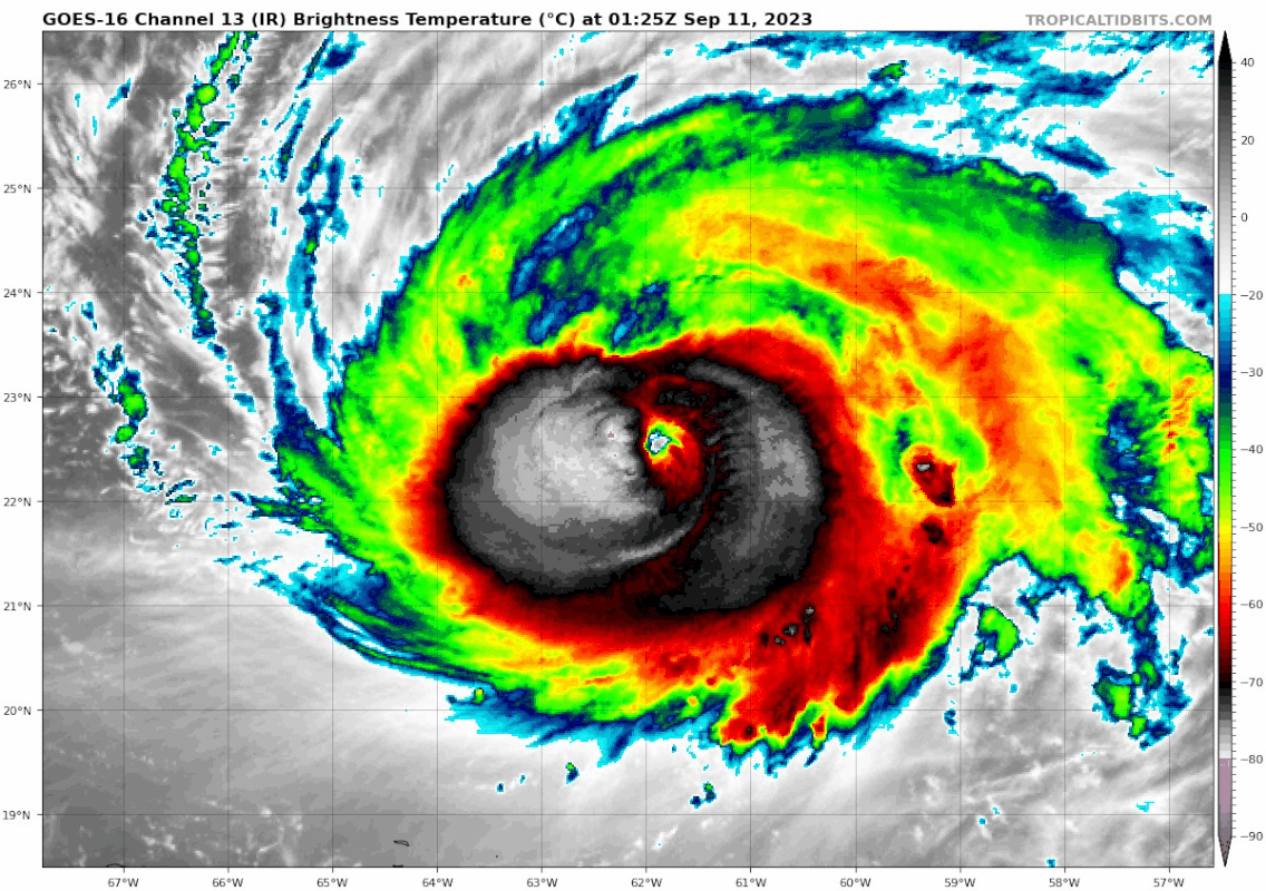
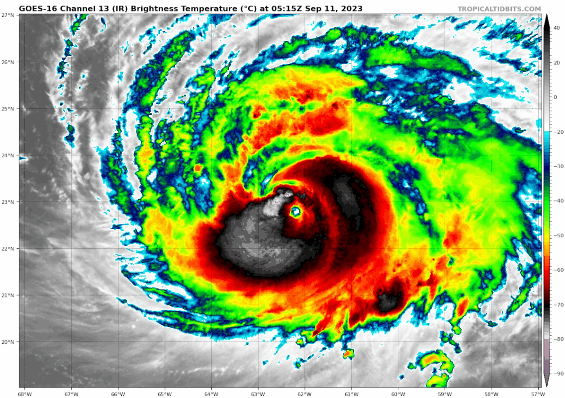
abajan wrote:
Kazmit wrote:Min pressure has continued to fall but winds have not caught up.

The winds will not necessarily increase. If the areal coverage of hurricane-force and storm-force winds continues to expand while the maximum sustained winds remain unchanged, Lee is actually getting stronger because it takes more energy to drive those winds over a larger area.


This could actually be worse than a tight, intense core. Lee will wind down slower over cool waters if it’s more spread out and massive. Also, the odds of having a major impact increases substantially since the storm will cover a vast area. Eastern New England is increasingly likely to have TS impacts and significant surge over a large area early next week. Nova Scotia will get impacted even if the center curves eastward and doesn’t landfall.
5 likes   
Fran '96, Georges '98, Gordon '00, Gabrielle '01, Charley '04, Frances '04, Jeanne '04, Barry '07, Fay '08, Debby '12, Matthew '16, Emily '17, Irma '17, Michael ‘18, Elsa ‘21, Fred ‘21, Mindy ‘21, Nicole ‘22, Idalia ‘23, Debby ‘24, Helene ‘24

User avatar
kevin
Category 5
Category 5
Posts: 2586
Age: 26
Joined: Wed Aug 28, 2019 4:35 am

Re: ATL: LEE - Hurricane - Discussion

#1715 Postby kevin » Mon Sep 11, 2023 7:56 am

Data from the last recon passes. The on average 22 nm RMW results in an undersampling correction factor of 5% for a cat 3.
Based on these passes I'd go with a current intensity of 947 mb and winds of 110 kt. 105 kt is a safe bet, but I'd increase it due to the exceptional eyewall drops.
However, due to Lee's erratic nature and fluctuating intensity I'd understand it if NHC keeps it at 110 kt. The last pass went through the NE and SW part of the eyewall while the N eyewall clearly has the strongest winds based on pass 1 and 2 as well as the eyewall drops so that's why I disregard the 3rd passes' wind measurements for the intensity. It does show how Lee's windfield is still not very symmetrical despite being a MH.

Pass 1
946.7 mb with 32 kt -> 943.5 mb
105 kt SFMR and 106 kt FL -> (106*0.9+105)/2*1.05 = 105 kt
RMW 27 nm

Pass 2
944.1 mb with 6 kt -> 943.5 mb
102 kt SFMR and 106 kt FL -> (106*0.9+102)/2*1.05 = 104 kt
RMW 20 nm

Pass 3
947.7 mb with 5 kt -> 947.2 mb
81 kt SFMR and 101 kt FL -> (101*0.9+81)/2*1.05 = 90 kt
RMW 19 nm

Eyewall drops
Drop 7 -> 09:59z -> 111 kt surface winds
Drop 9 -> 09:59z -> 120 kt surface winds
Slight correction since the eyewall drops can possibly be contaminated with gusts so I estimate winds of 110 - 115 kt.

Eyedrops
949 mb with 11 kt -> 948 mb
948 mb with 2 kt -> 948 mb
3 likes   

User avatar
kevin
Category 5
Category 5
Posts: 2586
Age: 26
Joined: Wed Aug 28, 2019 4:35 am

Re: ATL: LEE - Hurricane - Discussion

#1716 Postby kevin » Mon Sep 11, 2023 8:06 am

Despite sort of looking like it's falling apart, Lee has *finally* entered a region of ~favorable shear (15 kt). Idk how long it'll last though. Only 6 hours ago it was under almost 30 kt of shear. This rapid decrease in shear might also be the reason for some of the weird core behavior by Lee (idk enough about shear to say that with any certainty though). But maybe, just maybe, Lee will intensify later today.

Image
0 likes   

User avatar
ElectricStorm
Category 5
Category 5
Posts: 5044
Age: 24
Joined: Tue Aug 13, 2019 11:23 pm
Location: Skiatook, OK / Norman, OK

Re: ATL: LEE - Hurricane - Discussion

#1717 Postby ElectricStorm » Mon Sep 11, 2023 8:07 am

Looks like it's still struggling with structure/dry air issues. With this structure it's probably not going to get nearly as strong for its second peak as I thought it would, but perhaps it can finally get going later today
0 likes   
B.S Meteorology, University of Oklahoma '25

Please refer to the NHC, NWS, or SPC for official information.

User avatar
cycloneye
Admin
Admin
Posts: 145294
Age: 68
Joined: Thu Oct 10, 2002 10:54 am
Location: San Juan, Puerto Rico

Re: ATL: LEE - Hurricane - Discussion

#1718 Postby cycloneye » Mon Sep 11, 2023 8:42 am

0 likes   
Visit the Caribbean-Central America Weather Thread where you can find at first post web cams,radars
and observations from Caribbean basin members Click Here

User avatar
cheezyWXguy
Category 5
Category 5
Posts: 6108
Joined: Mon Feb 13, 2006 12:29 am
Location: Dallas, TX

Re: ATL: LEE - Hurricane - Discussion

#1719 Postby cheezyWXguy » Mon Sep 11, 2023 8:53 am

Lee has clearly been undergoing a grungy ERC since last night and looks to be more or less wrapping it up now. Looks like a huge outer eye while the inner is generally just a cirrus canopy at this point. I doubt there will be much intensification today, it looks like a lot of dry air has been ingested in the process and the pressure gradient has probably flattened, but I guess we’ll see.
1 likes   

User avatar
Hurricane2022
Category 5
Category 5
Posts: 1541
Joined: Tue Aug 23, 2022 11:38 pm
Location: Araçatuba, Brazil

Re: ATL: LEE - Hurricane - Discussion

#1720 Postby Hurricane2022 » Mon Sep 11, 2023 9:09 am

the inner eyewall is almost gone on VIS now.
0 likes   
Sorry for the bad English sometimes...!
For reliable and detailed information for any meteorological phenomenon, please consult the National Hurricane Center, Joint Typhoon Warning Center , or your local Meteo Center.

--------

Una cvm Christo, pro Christo, et in Christo. Sit nomen Domini benedictvm.


Return to “2023”

Who is online

Users browsing this forum: No registered users and 5 guests