
By the way, NCEP is not the best reanalysis model for VP.
Moderator: S2k Moderators


SFLcane wrote:This pattern currently in place concerns me in October in the caribbean in particualr for the the florida peninsula even though there's a subtropical jet across the Gulf.
jconsor wrote:I think we need to watch the eastern Caribbean in late Sep. Also expecting more NW Caribbean activity than usual in Oct-Nov for an El Nino.
https://twitter.com/yconsor/status/1701549729803297243
https://twitter.com/yconsor/status/1701577706637242411
https://twitter.com/yconsor/status/1701583064885874875


Ianswfl wrote:SFLcane wrote:This pattern currently in place concerns me in October in the caribbean in particualr for the the florida peninsula even though there's a subtropical jet across the Gulf.
You think a risk for an Wilma, or Ian in oct for me? What about November with the warm waters? Another Kate 1985?
IcyTundra wrote:Ianswfl wrote:SFLcane wrote:This pattern currently in place concerns me in October in the caribbean in particualr for the the florida peninsula even though there's a subtropical jet across the Gulf.
You think a risk for an Wilma, or Ian in oct for me? What about November with the warm waters? Another Kate 1985?
There is always a risk for Florida in October when the CAG (Central American Gyre) really starts to get going. We will see if the Nino shear reduces the risk in October but I wouldn't count on it.
SFLcane wrote:It’s almost time to watch the Caribbean!
https://i.postimg.cc/YSBjDqPx/IMG-7617.png
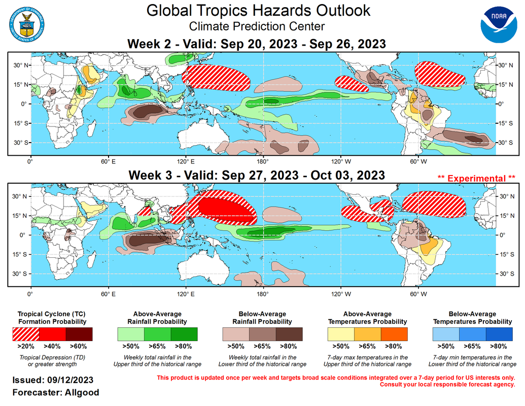
Although both the remnant MJO signal and El Nino conditions are broadly unfavorable for tropical cyclone development during Week-2, warm SSTs and a continued high climatological favorability support at least a slight potential for additional development over the MDR both during Week-2 and Week-3. Suppressed convection has precluded development over the Caribbean and Gulf of Mexico recently, and this pattern is favored to persist into Week-2; however, dynamical models indicate an increasing potential for development in these regions by Week-3.
WalterWhite wrote:Even with the unfavorable MJO in September, however, I still think we are going to get to at the very least Philippe (and likely Rina) by the end of September.

zzzh wrote:WalterWhite wrote:Even with the unfavorable MJO in September, however, I still think we are going to get to at the very least Philippe (and likely Rina) by the end of September.
We never had unfavorable MJO since June. MJO has been stuck in Phase 1-2 for over 80 days and we had 0 Pacific MJO event. It is currently in phase 3/4 which suppresses EPAC and that favors the Atlantic as well.

IcyTundra wrote:Ianswfl wrote:SFLcane wrote:This pattern currently in place concerns me in October in the caribbean in particualr for the the florida peninsula even though there's a subtropical jet across the Gulf.
You think a risk for an Wilma, or Ian in oct for me? What about November with the warm waters? Another Kate 1985?
There is always a risk for Florida in October when the CAG (Central American Gyre) really starts to get going. We will see if the Nino shear reduces the risk in October but I wouldn't count on it.
CFLHurricane wrote:IcyTundra wrote:Ianswfl wrote:You think a risk for an Wilma, or Ian in oct for me? What about November with the warm waters? Another Kate 1985?
There is always a risk for Florida in October when the CAG (Central American Gyre) really starts to get going. We will see if the Nino shear reduces the risk in October but I wouldn't count on it.
Personally I’m feeling mighty relaxed about the foreseeable season here on the Space Coast. These unusually strong autumnal fronts are shielding us from the east and there’s nothing for the rest of September on the models for several runs now. I do think there will be an October major or two due to the record warmth but my gut is saying most of the season is behind us.
zzzh wrote:https://i.imgur.com/B5M7AG4.png
By the way, NCEP is not the best reanalysis model for VP.


NDG wrote:zzzh wrote:https://i.imgur.com/B5M7AG4.png
By the way, NCEP is not the best reanalysis model for VP.
Perhaps, but we all know 2004 had a slow and late start, second half of the hurricane season it paints a different picture on its reanalysis especially for September.
https://i.imgur.com/5cF2Ao0.png
https://i.imgur.com/wbvylZt.png


Cachondo23 wrote:Its been exactly one month since the NHC started tracking what would be TS Gert and we have Nigel coming soon. Crazy stuff.
On another note, GFS “happy hour” tracking yet another wave moving due west into the Caribbean. Cabo Verde season wont stop but still no model support at all.
¿Donde esta El Niño?


Users browsing this forum: No registered users and 166 guests
