Eastern and Central Tropical Atlantic (AL97):
A broad area of low pressure over the eastern tropical Atlantic
continues to produce some disorganized showers and thunderstorms.
Gradual development of this system is expected over the next few
days while the system moves west-northwestward to northwestward at
10 to 15 mph, and a tropical depression is likely to form by this
weekend over the central tropical Atlantic.
* Formation chance through 48 hours...medium...50 percent.
* Formation chance through 7 days...high...80 percent.
$$
Forecaster Bucci
ATL: NIGEL - Post-Tropical - Discussion
Moderator: S2k Moderators
-
Sciencerocks
- Category 5

- Posts: 10181
- Age: 40
- Joined: Thu Jul 06, 2017 1:51 am
Re: ATL: INVEST 97L - Discussion
0 likes

-
MEANINGLESS_NUMBERS
- Category 2

- Posts: 503
- Joined: Mon Nov 02, 2020 1:43 pm
Re: ATL: INVEST 97L - Discussion
Another one to watch in Bermuda. For the third time this season we are under a Warning with the next storm coming down the pike. We’re a magnet this year…
1 likes
Emily '87, Felix '95, Gert '99, Fabian '03, Humberto '19, Paulette '20, Teddy '20, Fiona '22, Lee '23, Ernesto '24, Humberto/Imelda '25

Re: ATL: INVEST 97L - Discussion
MEANINGLESS_NUMBERS wrote:Another one to watch in Bermuda. For the third time this season we are under a Warning with the next storm coming down the pike. We’re a magnet this year…
The past few years have been extremely active for us. Bermuda is near the top of the list of places most frequently hit by hurricanes.
https://hurricanecity.com/rank.htm
Luckily, they're typically quantity over quality. Fabian was the last really bad one.
2 likes
Igor 2010, Sandy 2012, Fay 2014, Gonzalo 2014, Joaquin 2015, Nicole 2016, Humberto 2019, Imelda 2025
I am only a tropical weather enthusiast. My predictions are not official and may or may not be backed by sound meteorological data. For official information, please refer to the NHC and NWS products.
I am only a tropical weather enthusiast. My predictions are not official and may or may not be backed by sound meteorological data. For official information, please refer to the NHC and NWS products.
-
WalterWhite

- Category 1

- Posts: 342
- Joined: Fri Mar 17, 2023 5:53 pm
Re: ATL: INVEST 97L - Discussion
Central Tropical Atlantic (AL97):
Showers and thunderstorms associated with a broad area of low
pressure located several hundred miles west-southwest of the Cabo
Verde Islands continue to become better organized this evening.
Environmental conditions are favorable for further development of
this system, and a tropical depression is likely to form by this
weekend as the low moves west-northwestward to northwestward at 10
to 15 mph across the central tropical Atlantic.
* Formation chance through 48 hours...high...80 percent.
* Formation chance through 7 days...high...90 percent.
1 likes


Re: ATL: INVEST 97L - Discussion
Kazmit wrote:MEANINGLESS_NUMBERS wrote:Another one to watch in Bermuda. For the third time this season we are under a Warning with the next storm coming down the pike. We’re a magnet this year…
The past few years have been extremely active for us. Bermuda is near the top of the list of places most frequently hit by hurricanes.
https://hurricanecity.com/rank.htm
Luckily, they're typically quantity over quality. Fabian was the last really bad one.
My next door neighbor's from there. She, and her son who lives there but frequently visits her, have often spoken of Fabian's ferocity.
2 likes
-
Sciencerocks
- Category 5
- Posts: 10181
- Age: 40
- Joined: Thu Jul 06, 2017 1:51 am

-
IsabelaWeather
- Category 1
- Posts: 316
- Age: 36
- Joined: Tue Jul 07, 2020 7:29 am
- Location: Isabela, Puerto Rico
Re: ATL: INVEST 97L - Discussion
Is it just me, or is this disturbance moving due W? NHC has it moving NW the whole time.
0 likes
-
MEANINGLESS_NUMBERS
- Category 2
- Posts: 503
- Joined: Mon Nov 02, 2020 1:43 pm
Re: ATL: INVEST 97L - Discussion
Kazmit wrote:MEANINGLESS_NUMBERS wrote:Another one to watch in Bermuda. For the third time this season we are under a Warning with the next storm coming down the pike. We’re a magnet this year…
The past few years have been extremely active for us. Bermuda is near the top of the list of places most frequently hit by hurricanes.
https://hurricanecity.com/rank.htm
Luckily, they're typically quantity over quality. Fabian was the last really bad one.
In 2019 Humberto took a piece of my roof. Not as bad as Fabian but it was a proper storm. And Fay and Gonzalo, both making direct landfalls as hurricanes in the same week, that was an interesting pair.
1 likes
Emily '87, Felix '95, Gert '99, Fabian '03, Humberto '19, Paulette '20, Teddy '20, Fiona '22, Lee '23, Ernesto '24, Humberto/Imelda '25
Re: ATL: INVEST 97L - Discussion
Looks like our next tropical depression is about to form:

Central Tropical Atlantic (AL97):
Showers and thunderstorms associated with a broad low pressure area
located about 1000 miles west-southwest of the Cabo Verde Islands
have increased and become a little better organized since yesterday.
Environmental conditions are expected to be conducive for additional
development, and this system is likely to become a tropical
depression during the day or so while it moves west-northwestward to
northwestward at 10 to 15 mph across the central tropical Atlantic.
* Formation chance through 48 hours...high...90 percent.
* Formation chance through 7 days...high...90 percent.
1 likes
-
MarioProtVI
- Category 5
- Posts: 1034
- Age: 24
- Joined: Sun Sep 29, 2019 7:33 pm
- Location: New Jersey
Re: ATL: INVEST 97L - Discussion
abajan wrote:Looks like our next tropical depression is about to form:Central Tropical Atlantic (AL97):
Showers and thunderstorms associated with a broad low pressure area
located about 1000 miles west-southwest of the Cabo Verde Islands
have increased and become a little better organized since yesterday.
Environmental conditions are expected to be conducive for additional
development, and this system is likely to become a tropical
depression during the day or so while it moves west-northwestward to
northwestward at 10 to 15 mph across the central tropical Atlantic.
* Formation chance through 48 hours...high...90 percent.
* Formation chance through 7 days...high...90 percent.
https://images2.imgbox.com/1c/74/RTSoocQi_o.gif
I think NHC’s 48-h is way too high. Still looks very broad and no sign of an LLC forming. Models don’t have genesis until Saturday/Sunday. Should be 60-70% 48-h IMO.
0 likes
-
SconnieCane
- Category 5
- Posts: 1013
- Joined: Thu Aug 02, 2018 5:29 pm
- Location: Madison, WI
Re: ATL: INVEST 97L - Discussion
IsabelaWeather wrote:Is it just me, or is this disturbance moving due W? NHC has it moving NW the whole time.
That shaded area on the TWO isn't a track cone, since there are no forecast track points for something that they aren't issuing advisories on. It's the area where genesis may occur with the disturbance in question.
Its size and orientation does imply a general direction of motion, but it should be used with caution.
1 likes
-
Sciencerocks
- Category 5
- Posts: 10181
- Age: 40
- Joined: Thu Jul 06, 2017 1:51 am

-
MEANINGLESS_NUMBERS
- Category 2
- Posts: 503
- Joined: Mon Nov 02, 2020 1:43 pm
Re: ATL: INVEST 97L - Discussion
MarioProtVI wrote:I think NHC’s 48-h is way too high. Still looks very broad and no sign of an LLC forming. Models don’t have genesis until Saturday/Sunday. Should be 60-70% 48-h IMO.
Today is Thursday; Saturday is <48 hours away.
4 likes
Emily '87, Felix '95, Gert '99, Fabian '03, Humberto '19, Paulette '20, Teddy '20, Fiona '22, Lee '23, Ernesto '24, Humberto/Imelda '25
-
IsabelaWeather
- Category 1
- Posts: 316
- Age: 36
- Joined: Tue Jul 07, 2020 7:29 am
- Location: Isabela, Puerto Rico
Re: ATL: INVEST 97L - Discussion
SconnieCane wrote:IsabelaWeather wrote:Is it just me, or is this disturbance moving due W? NHC has it moving NW the whole time.
That shaded area on the TWO isn't a track cone, since there are no forecast track points for something that they aren't issuing advisories on. It's the area where genesis may occur with the disturbance in question.
Its size and orientation does imply a general direction of motion, but it should be used with caution.
That's not really true, though. The highlighted area is the area they expect a COC to form. Since it is narrow and slanted NW they obviously expect the main disturbed weather to move to the NW.
In fact, the NHC even says so.
...and this system is likely to become a tropical
depression during the day or so while it moves west-northwestward to
northwestward at 10 to 15 mph across the central tropical Atlantic...
As the day goes on it looks more and more westward, so I dont see why they don't show that.
0 likes
-
Sciencerocks
- Category 5
- Posts: 10181
- Age: 40
- Joined: Thu Jul 06, 2017 1:51 am
Re: ATL: INVEST 97L - Discussion

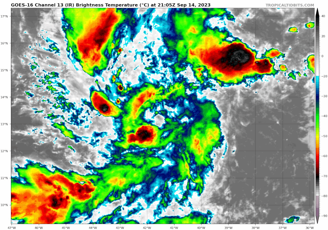
Nice LLC forming! I think we're within 12 or so hours away from a depression with the organization of the convection forming ontop of the LLC.
1 likes
Re: ATL: INVEST 97L - Discussion
MEANINGLESS_NUMBERS wrote:Another one to watch in Bermuda. For the third time this season we are under a Warning with the next storm coming down the pike. We’re a magnet this year…
Everybody gets a turn in the barrel....
0 likes
Cleo - 1964, Betsy - 1965, David - 1979, Andrew - 1992, Charlie (Francis, Ivan, Jeanne) - 2004, Irma - 2017, Ian - 2022, Milton - 2024
-
cycloneye

- Admin

- Posts: 149298
- Age: 69
- Joined: Thu Oct 10, 2002 10:54 am
- Location: San Juan, Puerto Rico
Re: ATL: INVEST 97L - Discussion
Central Tropical Atlantic (AL97):
Showers and thunderstorms continue to show some signs of
organization in association with a broad low pressure area located
about midway between the Lesser Antilles and the Cabo Verde Islands.
Environmental conditions are expected to be conducive for additional
development, and this system is very likely to become a tropical
depression during the next day or so while it moves
west-northwestward to northwestward at 10 to 15 mph across the
central tropical Atlantic.
* Formation chance through 48 hours...high...90 percent.
* Formation chance through 7 days...high...90 percent.
0 likes
Visit the Caribbean-Central America Weather Thread where you can find at first post web cams,radars
and observations from Caribbean basin members Click Here
and observations from Caribbean basin members Click Here
Re: ATL: INVEST 97L - Discussion
Condition looks favorable. Wouldn't be surprised if it becomes another major hurricane.
1 likes
Re: ATL: INVEST 97L - Discussion
And God said, "Let there be convection," and there was convection.
3 likes
TC naming lists: retirements and intensity
Most aggressive Advisory #1's in North Atlantic (cr. kevin for starting the list)
Most aggressive Advisory #1's in North Atlantic (cr. kevin for starting the list)
Who is online
Users browsing this forum: No registered users and 55 guests