2023 Indicators (SST, SAL, MSLP, Wind shear, Steering, Instability) and Day 16+ Models

This is the general tropical discussion area. Anyone can take their shot at predicting a storms path.

Moderator: S2k Moderators

Forum rules

The posts in this forum are NOT official forecasts and should not be used as such. They are just the opinion of the poster and may or may not be backed by sound meteorological data. They are NOT endorsed by any professional institution or STORM2K. For official information, please refer to products from the National Hurricane Center and National Weather Service.

Help Support Storm2K
Message
Author
User avatar
REDHurricane
Category 1
Category 1
Posts: 394
Age: 27
Joined: Sun Jul 03, 2022 2:36 pm
Location: Northeast Pacific Ocean

Re: 2023 Indicators (SST, SAL, MSLP, Wind shear, Steering, Instability) and Day 16+ Models

#1581 Postby REDHurricane » Fri Sep 15, 2023 2:48 pm

aspen wrote:We’ve passed 100 ACE already. With Nigel and possibly Ophelia on the way in the next week or so, this season could finish with 130-140+ ACE, far higher than last year in a La Niña.


I'm thinking 140 ACE should pretty much be a lock at this point, and hyperactive (>165) is looking more likely than not:

Image
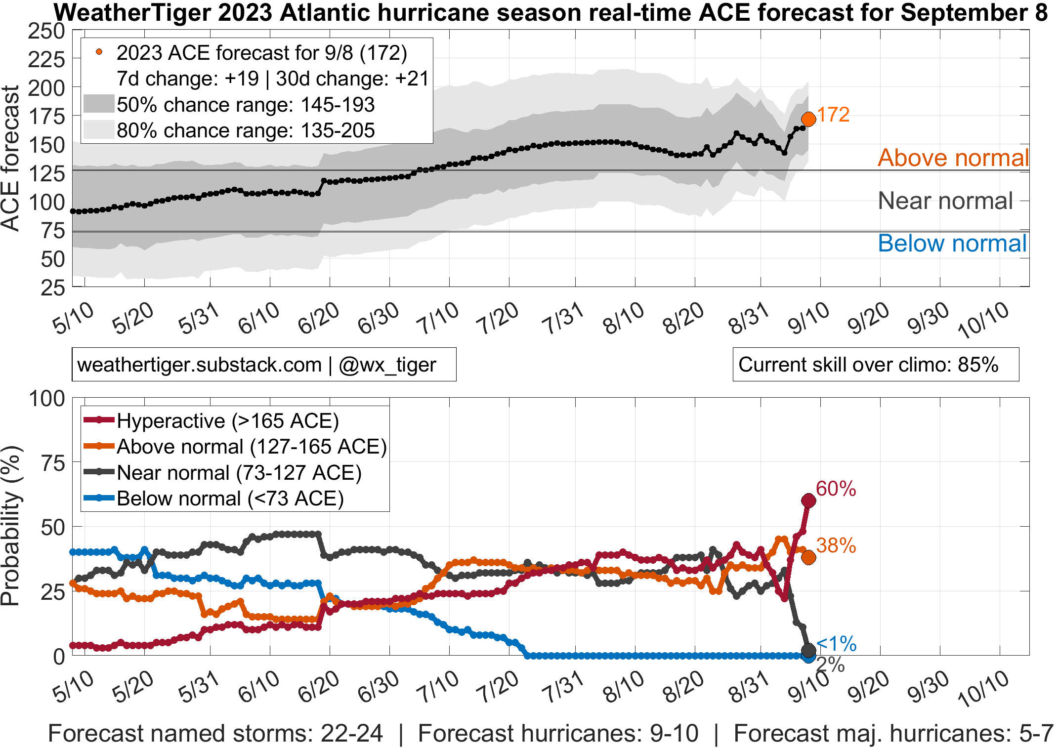
(Note this was last updated a week ago so WeatherTIger's actual forecast for today would be higher)

The real question in my mind is, are we going to approach or exceed ~200 ACE like the UKMET and University of Arizona have been predicting all along? We've probably got at least 2 more CV long trackers coming up in the next few weeks, plus anything that might spin up in the Caribbean or Gulf throughout the entirety of October and November. I'd give it about a 1/3 chance of reaching 200 right now, but it'll depend a lot on how Margot/Nigel end up performing before the CV season starts to subside.
2 likes   

WeatherBoy2000
Category 1
Category 1
Posts: 280
Joined: Mon Apr 10, 2023 9:29 am

Re: 2023 Indicators (SST, SAL, MSLP, Wind shear, Steering, Instability) and Day 16+ Models

#1582 Postby WeatherBoy2000 » Fri Sep 15, 2023 3:18 pm

Despite CDAS's cold bias, since mid August the tropical Atlantic has continued to get even warmer:

Image

Image

Contrasted with the critical enso 3.4:

Image

Both are roughly neck and neck when it comes to anomalous warmth. This is probably a big reason why the el nino so far has failed to suppress the Atlantic in any meaningful way. Nigel looks to be another big ace maker and there's a signal for another long tracking CV storm around the 20th-25th range.
1 likes   

User avatar
Hurricane2022
Category 5
Category 5
Posts: 1496
Joined: Tue Aug 23, 2022 11:38 pm
Location: Araçatuba, Brazil

Re: 2023 Indicators (SST, SAL, MSLP, Wind shear, Steering, Instability) and Day 16+ Models

#1583 Postby Hurricane2022 » Fri Sep 15, 2023 3:53 pm

0 likes   
Sorry for the bad English sometimes...!
For reliable and detailed information for any meteorological phenomenon, please consult the National Hurricane Center, Joint Typhoon Warning Center , or your local Meteo Center.

--------

Una cvm Christo, pro Christo, et in Christo. Sit nomen Domini benedictvm.

Ianswfl
Category 1
Category 1
Posts: 482
Joined: Thu Mar 23, 2023 11:11 pm

Re: 2023 Indicators (SST, SAL, MSLP, Wind shear, Steering, Instability) and Day 16+ Models

#1584 Postby Ianswfl » Sat Sep 16, 2023 4:26 pm

Latest CFSv2 next June has similar very similar warm SST setup to this season, except has the Caribbean sea more above normal that earlier this season. If it's a hyperactive season that would favor stronger Carribean systems, and of course possible stronger system entering the Gulf if we get a long tracker like Ivan. :eek:

Image
0 likes   

User avatar
Teban54
Category 5
Category 5
Posts: 3168
Joined: Sat May 19, 2018 1:19 pm

Re: 2023 Indicators (SST, SAL, MSLP, Wind shear, Steering, Instability) and Day 16+ Models

#1585 Postby Teban54 » Sat Sep 16, 2023 4:42 pm

Ianswfl wrote:Latest CFSv2 next June has similar very similar warm SST setup to this season, except has the Caribbean sea more above normal that earlier this season. If it's a hyperactive season that would favor stronger Carribean systems, and of course possible stronger system entering the Gulf if we get a long tracker like Ivan. :eek:

https://www.tropicaltidbits.com/analysis/models/cfs-mon/2023091606/cfs-mon_01_ssta_atl_9.png

Wrong thread, make a 2024 indicators thread and post it there :lol:
4 likes   

User avatar
Hurricane2022
Category 5
Category 5
Posts: 1496
Joined: Tue Aug 23, 2022 11:38 pm
Location: Araçatuba, Brazil

Re: 2023 Indicators (SST, SAL, MSLP, Wind shear, Steering, Instability) and Day 16+ Models

#1586 Postby Hurricane2022 » Sat Sep 16, 2023 5:01 pm

Teban54 wrote:
Ianswfl wrote:Latest CFSv2 next June has similar very similar warm SST setup to this season, except has the Caribbean sea more above normal that earlier this season. If it's a hyperactive season that would favor stronger Carribean systems, and of course possible stronger system entering the Gulf if we get a long tracker like Ivan. :eek:

https://www.tropicaltidbits.com/analysis/models/cfs-mon/2023091606/cfs-mon_01_ssta_atl_9.png

Wrong thread, make a 2024 indicators thread and post it there :lol:

But we're barely past the peak of the current hurricane season :lol:
0 likes   
Sorry for the bad English sometimes...!
For reliable and detailed information for any meteorological phenomenon, please consult the National Hurricane Center, Joint Typhoon Warning Center , or your local Meteo Center.

--------

Una cvm Christo, pro Christo, et in Christo. Sit nomen Domini benedictvm.

User avatar
weeniepatrol
Category 5
Category 5
Posts: 1252
Joined: Sat Aug 22, 2020 5:30 pm
Location: WA State

Re: 2023 Indicators (SST, SAL, MSLP, Wind shear, Steering, Instability) and Day 16+ Models

#1587 Postby weeniepatrol » Sat Sep 16, 2023 7:43 pm

Ianswfl wrote:Latest CFSv2 next June has similar very similar warm SST setup to this season, except has the Caribbean sea more above normal that earlier this season. If it's a hyperactive season that would favor stronger Carribean systems, and of course possible stronger system entering the Gulf if we get a long tracker like Ivan. :eek:

https://www.tropicaltidbits.com/analysis/models/cfs-mon/2023091606/cfs-mon_01_ssta_atl_9.png


There are reasons to weigh solutions like this one more than usual, but even still given the timeframe we will have to wait and see. As of right now, next year does look spooky. Climate guidance also shows La Niña developing by next Summer
1 likes   

zzzh
Category 3
Category 3
Posts: 833
Joined: Thu Sep 02, 2021 1:13 pm

Re: 2023 Indicators (SST, SAL, MSLP, Wind shear, Steering, Instability) and Day 16+ Models

#1588 Postby zzzh » Sat Sep 16, 2023 8:14 pm

Post Nino years are usually favorable.
2 likes   

User avatar
WalterWhite
Category 1
Category 1
Posts: 342
Joined: Fri Mar 17, 2023 5:53 pm

Re: 2023 Indicators (SST, SAL, MSLP, Wind shear, Steering, Instability) and Day 16+ Models

#1589 Postby WalterWhite » Sat Sep 16, 2023 8:57 pm

2020 now has 15 storms as of September 17 00:00 UTC. The only seasons that had more storms by that time were 2005 and 2020. This means that, depending on how the rest of the season goes, 2021 could exhaust the main naming list.

Exhausting the main naming list would require only 6 more storms to form, which is more realistic than some might think. That could happen if 3 more storms form this September, 2 form in October, and 1 forms in November. Alternatively, that could happen if 4 more storms form this September, 1 forms in October, and 1 forms in November. Alternatively, that could happen if 2 more storms form this September, 3 form in October, and 1 forms in November. Alternatively, that could happen if 3 more storms form this September and 3 form in October.

With how many storms recent Septembers have had (2018 and 2019 with 7, 2020 with 10, 2021 with 9, and 2022 with 6), it seems probable that 2023 will get quite close to exhausting the main list, if not exhausting it outright.

EDIT: Exhausting the main naming list would require 7 more storms to form because Subtropical Storm 01L was unnamed. Still, this is very much possible.
0 likes   

User avatar
WalterWhite
Category 1
Category 1
Posts: 342
Joined: Fri Mar 17, 2023 5:53 pm

Re: 2023 Indicators (SST, SAL, MSLP, Wind shear, Steering, Instability) and Day 16+ Models

#1590 Postby WalterWhite » Sat Sep 16, 2023 9:05 pm

The five most recent seasons have had at least five or more storms form after September 17.

2018: 5 storms (Kirk, Leslie, Michael, Nadine, and Oscar)
2019: 8 storms (Karen, Lorenzo, Melissa, Nestor, Pablo, Olga, Rebekah, and Sebastien)
2020: 7 storms (Gamma, Delta, Epsilon, Zeta, Eta, Theta, and Iota)
2021: 5 storms (Peter, Rose, Sam, Teresa, Victor, and Wanda)
2022: 8 storms (Gaston, Ian, Hermine, Julia, Karl, Lisa, Martin, and Nicole)

The minimum storm count after September 17 is 5, and the average storm count after September 17 is 7. Given that 2023 already has 15 storms, the year should, if it follows the patterns of previous hurricane seasons, end with approximately 22 storms.
0 likes   

User avatar
Hurricane2022
Category 5
Category 5
Posts: 1496
Joined: Tue Aug 23, 2022 11:38 pm
Location: Araçatuba, Brazil

Re: 2023 Indicators (SST, SAL, MSLP, Wind shear, Steering, Instability) and Day 16+ Models

#1591 Postby Hurricane2022 » Sat Sep 16, 2023 9:59 pm

WalterWhite wrote:That could happen if 3 more storms form this September, 2 form in October, and 1 forms in November. Alternatively, that could happen if 4 more storms form this September, 1 forms in October, and 1 forms in November. Alternatively, that could happen if 2 more storms form this September, 3 form in October, and 1 forms in November. Alternatively, that could happen if 3 more storms form this September and 3 form in October.


Image
2 likes   
Sorry for the bad English sometimes...!
For reliable and detailed information for any meteorological phenomenon, please consult the National Hurricane Center, Joint Typhoon Warning Center , or your local Meteo Center.

--------

Una cvm Christo, pro Christo, et in Christo. Sit nomen Domini benedictvm.


Ianswfl
Category 1
Category 1
Posts: 482
Joined: Thu Mar 23, 2023 11:11 pm

Re: 2023 Indicators (SST, SAL, MSLP, Wind shear, Steering, Instability) and Day 16+ Models

#1593 Postby Ianswfl » Sat Sep 16, 2023 10:18 pm

weeniepatrol wrote:
Ianswfl wrote:Latest CFSv2 next June has similar very similar warm SST setup to this season, except has the Caribbean sea more above normal that earlier this season. If it's a hyperactive season that would favor stronger Carribean systems, and of course possible stronger system entering the Gulf if we get a long tracker like Ivan. :eek:

https://www.tropicaltidbits.com/analysis/models/cfs-mon/2023091606/cfs-mon_01_ssta_atl_9.png


There are reasons to weigh solutions like this one more than usual, but even still given the timeframe we will have to wait and see. As of right now, next year does look spooky. Climate guidance also shows La Niña developing by next Summer


Yea, from a landfall standpoint next year I think will be a biggie, especially with the Caribbean possibly boiling. This year it's the open atlantic fish storms. Next year with no El Nino I expect the threads to be in the Gulf and Caribbean more. This could be a 2004 or 2005 landfall type season next year.
1 likes   

User avatar
ScottNAtlanta
Category 5
Category 5
Posts: 2360
Joined: Sat May 25, 2013 3:11 pm
Location: Atlanta, GA

Re: 2023 Indicators (SST, SAL, MSLP, Wind shear, Steering, Instability) and Day 16+ Models

#1594 Postby ScottNAtlanta » Sat Sep 16, 2023 10:20 pm

With the El Nino winter weather preferred storm tracks...that could take some of the heat out of the GOM and the East Coast. Those Miller A type storms are usually very prevalent inn El Nino winters. That produces a lot of snow in the SE US and all the way up the coast. Warmer water in the GOM feeds those type storms too.
0 likes   
The posts in this forum are NOT official forecast and should not be used as such. They are just the opinion of the poster and may or may not be backed by sound meteorological data. They are NOT endorsed by any professional institution or storm2k.org. For official information, please refer to the NHC and NWS products.

User avatar
WalterWhite
Category 1
Category 1
Posts: 342
Joined: Fri Mar 17, 2023 5:53 pm

Re: 2023 Indicators (SST, SAL, MSLP, Wind shear, Steering, Instability) and Day 16+ Models

#1595 Postby WalterWhite » Sun Sep 17, 2023 7:24 am

GEFS ensembles are indicating that later this month:

- Tropical Storm Nigel could become Major Hurricane Nigel.
- The 0%/40% disturbance marked by the National Hurricane Center could become Major Hurricane Ophelia.
- A disturbance off the East Coast could become Tropical Storm Philippe.
- Energy from the Central American Gyre could become Tropical Storm Rina in the Gulf of Mexico or the Caribbean Sea.

This alone would bring the 2023 Atlantic Hurricane Season to 18 storms, 7 hurricanes, and 5 major hurricanes. These past few Septembers (2018, 2019, 2020, 2021, and 2022) have featured a large quantity of storms, and 2023 appears to be no exception.
0 likes   

User avatar
WalterWhite
Category 1
Category 1
Posts: 342
Joined: Fri Mar 17, 2023 5:53 pm

Re: 2023 Indicators (SST, SAL, MSLP, Wind shear, Steering, Instability) and Day 16+ Models

#1596 Postby WalterWhite » Sun Sep 17, 2023 8:31 am

From 2018 to 2022, the Atlantic has produced, on average, 1.8 major hurricanes (approximately 2) after September 20.

2018: Michael
2019: Lorenzo
2020: Delta, Epsilon, Zeta, Eta, and Iota
2021: Sam
2022: Ian

This means that, even if Tropical Storm Nigel becomes a major hurricane, we should expect about 2 more major hurricanes after that, which should give the 2023 Atlantic Hurricane Season about 6 major hurricanes by the time the season is finished.
0 likes   

User avatar
Category5Kaiju
Category 5
Category 5
Posts: 4051
Joined: Thu Dec 24, 2020 12:45 pm
Location: Seattle

Re: 2023 Indicators (SST, SAL, MSLP, Wind shear, Steering, Instability) and Day 16+ Models

#1597 Postby Category5Kaiju » Sun Sep 17, 2023 9:47 am

You can surely bet that this season will really cause wx enthusiasts to re-consider the exact role El Nino plays in relation to Atlantic activity, especially with the idea that the Atlantic basin may not be as cool as it was in past years going forward.
4 likes   
Unless explicitly stated, all info in my posts is based on my own opinions and observations. Tropical storms and hurricanes can be extremely dangerous. Do not think you can beat Mother Nature. Refer to an accredited weather research agency or meteorologist if you need to make serious decisions regarding an approaching storm.

User avatar
WalterWhite
Category 1
Category 1
Posts: 342
Joined: Fri Mar 17, 2023 5:53 pm

Re: 2023 Indicators (SST, SAL, MSLP, Wind shear, Steering, Instability) and Day 16+ Models

#1598 Postby WalterWhite » Sun Sep 17, 2023 9:53 am

Category5Kaiju wrote:You can surely bet that this season will really cause wx enthusiasts to re-consider the exact role El Nino plays in relation to Atlantic activity, especially with the idea that the Atlantic basin may not be as cool as it was in past years going forward.

It is all related to the West African Monsoon. At this point, the West African Monsoon is like an insurance policy for the North Atlantic: it protects the basin from below-average activity.
0 likes   

User avatar
NotSparta
Professional-Met
Professional-Met
Posts: 1668
Age: 23
Joined: Fri Aug 18, 2017 8:24 am
Location: Naples, FL
Contact:

Re: 2023 Indicators (SST, SAL, MSLP, Wind shear, Steering, Instability) and Day 16+ Models

#1599 Postby NotSparta » Sun Sep 17, 2023 11:05 am

Category5Kaiju wrote:You can surely bet that this season will really cause wx enthusiasts to re-consider the exact role El Nino plays in relation to Atlantic activity, especially with the idea that the Atlantic basin may not be as cool as it was in past years going forward.


El Nino still has the same effect, it's just the Atlantic got so warm it overpowered the El Nino signal
6 likes   
This post was probably an opinion of mine, and in no way is official. Please refer to http://www.hurricanes.gov for official tropical analysis and advisories.

My website, with lots of tropical wx graphics, including satellite and recon: http://cyclonicwx.com

User avatar
WalterWhite
Category 1
Category 1
Posts: 342
Joined: Fri Mar 17, 2023 5:53 pm

Re: 2023 Indicators (SST, SAL, MSLP, Wind shear, Steering, Instability) and Day 16+ Models

#1600 Postby WalterWhite » Sun Sep 17, 2023 12:16 pm

NotSparta wrote:
Category5Kaiju wrote:You can surely bet that this season will really cause wx enthusiasts to re-consider the exact role El Nino plays in relation to Atlantic activity, especially with the idea that the Atlantic basin may not be as cool as it was in past years going forward.


El Nino still has the same effect, it's just the Atlantic got so warm it overpowered the El Nino signal


This year, El Niño has barely had an impact on Caribbean vertical wind shear. Wind shear has been near-average these past few months. It might technically be an El Niño year, but atmospherically, it seems more like an ENSO neutral year.
0 likes   


Return to “Talkin' Tropics”

Who is online

Users browsing this forum: Long John and 204 guests