ATL: NIGEL - Models
Moderator: S2k Moderators
-
WalterWhite

- Category 1

- Posts: 342
- Joined: Fri Mar 17, 2023 5:53 pm
ATL: NIGEL - Models
Last edited by WalterWhite on Sat Sep 16, 2023 8:47 pm, edited 1 time in total.
0 likes

Re: ATL: INVEST 97L - Models
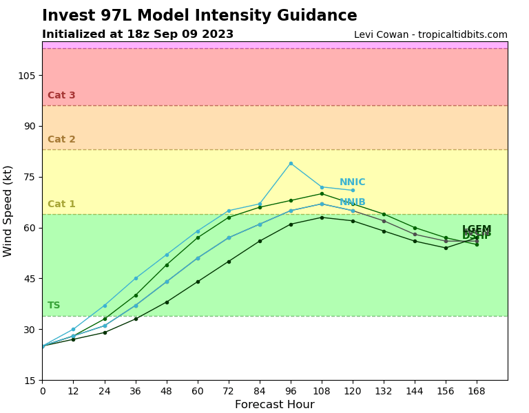
WalterWhite wrote:https://i.postimg.cc/NjW7r1RC/97-L-intensity-latest.png
Surprisingly aggressive intensity forecast considering people thought in the 97L discussion thread that it will likely not become anything more than a TD or weak TS.
0 likes
TC naming lists: retirements and intensity
Most aggressive Advisory #1's in North Atlantic (cr. kevin for starting the list)
Most aggressive Advisory #1's in North Atlantic (cr. kevin for starting the list)
-
WalterWhite
- Category 1
- Posts: 342
- Joined: Fri Mar 17, 2023 5:53 pm

Re: ATL: INVEST 97L - Models
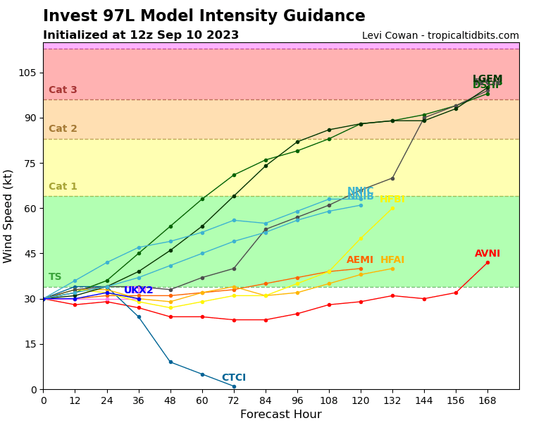
this looks to recurve well east of florida and the entire east coast, however bermuda needs to be alert as the gfs goes just east while the euro goes just west of bermuda
0 likes
-
MEANINGLESS_NUMBERS
- Category 2

- Posts: 503
- Joined: Mon Nov 02, 2020 1:43 pm
Re: ATL: INVEST 97L - Models
12z GFS puts Bermuda in the western eyewall at 180 hours. That would make this our fourth hurricane in three weeks: Franklin, Idalia, Lee, and... I guess this will be Nigel?
1 likes
Emily '87, Felix '95, Gert '99, Fabian '03, Humberto '19, Paulette '20, Teddy '20, Fiona '22, Lee '23, Ernesto '24, Humberto/Imelda '25
-
MEANINGLESS_NUMBERS
- Category 2
- Posts: 503
- Joined: Mon Nov 02, 2020 1:43 pm
Re: ATL: INVEST 97L - Models

Well that's not great.
0 likes
Emily '87, Felix '95, Gert '99, Fabian '03, Humberto '19, Paulette '20, Teddy '20, Fiona '22, Lee '23, Ernesto '24, Humberto/Imelda '25
-
ScottNAtlanta

- Category 5

- Posts: 2535
- Joined: Sat May 25, 2013 3:11 pm
- Location: Atlanta, GA
Re: ATL: INVEST 97L - Models
mantis83 wrote:this looks to recurve well east of florida and the entire east coast, however bermuda needs to be alert as the gfs goes just east while the euro goes just west of bermuda
It's a little too early to make a statement like that. I just looked at the latest GFS and EPS, and it seems future Nigel's track could be heavily influenced by what Margot does long term. The GFS seems to think Margot will curve around west and come back to as far south as 30N. I find that kinda hard to believe looking at the pattern. If Margot does not do that then you will have the high pressure coming off of Atlantic Canada joining with the high pressure in the Atlantic effectively blocking Nigel's northern progress. As of now...everything is on the table because we don't have a classified system to track yet.
4 likes
The posts in this forum are NOT official forecast and should not be used as such. They are just the opinion of the poster and may or may not be backed by sound meteorological data. They are NOT endorsed by any professional institution or storm2k.org. For official information, please refer to the NHC and NWS products.
Re: ATL: INVEST 97L - Models
that's a good point. yesterday's cmc seemed to join the highs together, while the gfs and euro show an escape route
0 likes
-
Iceresistance

- Category 5
- Posts: 9610
- Age: 22
- Joined: Sat Oct 10, 2020 9:45 am
- Location: Tecumseh, OK/Norman, OK
Re: ATL: INVEST 97L - Models
0 likes
Bill 2015 & Beta 2020
Winter 2020-2021
All observations are in Tecumseh, OK unless otherwise noted.
Winter posts are focused mainly for Oklahoma & Texas.
Take any of my forecasts with a grain of salt, refer to the NWS, SPC, and NHC for official information
Never say Never with weather! Because ANYTHING is possible!
Winter 2020-2021
All observations are in Tecumseh, OK unless otherwise noted.
Winter posts are focused mainly for Oklahoma & Texas.
Take any of my forecasts with a grain of salt, refer to the NWS, SPC, and NHC for official information
Never say Never with weather! Because ANYTHING is possible!
-
ElectricStorm

- Category 5
- Posts: 5164
- Age: 25
- Joined: Tue Aug 13, 2019 11:23 pm
- Location: Norman, OK
ATL: FIFTEEN - Tropical Depression - Discussion
12z hurricane models are generally showing a pretty broad core, which would likely prevent this from becoming too strong. Of the four models, only the HWRF has it becoming a major. Not surprised the NHC bumped the peak down slightly, although this becoming a major is still very possible (maybe even likely)
18z runs are about to start, we'll see if they're similar to the 12z runs
18z runs are about to start, we'll see if they're similar to the 12z runs
0 likes
B.S Meteorology, University of Oklahoma '25
Please refer to the NHC, NWS, or SPC for official information.
Please refer to the NHC, NWS, or SPC for official information.
-
ElectricStorm
- Category 5
- Posts: 5164
- Age: 25
- Joined: Tue Aug 13, 2019 11:23 pm
- Location: Norman, OK
Re: ATL: FIFTEEN - Tropical Depression - Discussion
Well so far both HAFS are much stronger with a tighter core. Both have a major by hour 63 and approaching Cat 4
0 likes
B.S Meteorology, University of Oklahoma '25
Please refer to the NHC, NWS, or SPC for official information.
Please refer to the NHC, NWS, or SPC for official information.
-
MEANINGLESS_NUMBERS
- Category 2
- Posts: 503
- Joined: Mon Nov 02, 2020 1:43 pm
Re: ATL: FIFTEEN - Tropical Depression - Discussion
Spaghetti continue to shift east, away from Bermuda.
0 likes
Emily '87, Felix '95, Gert '99, Fabian '03, Humberto '19, Paulette '20, Teddy '20, Fiona '22, Lee '23, Ernesto '24, Humberto/Imelda '25
-
WalterWhite
- Category 1
- Posts: 342
- Joined: Fri Mar 17, 2023 5:53 pm
-
TallyTracker
- Category 2
- Posts: 787
- Joined: Thu Oct 11, 2018 2:46 pm
Re: ATL: NIGEL - Models
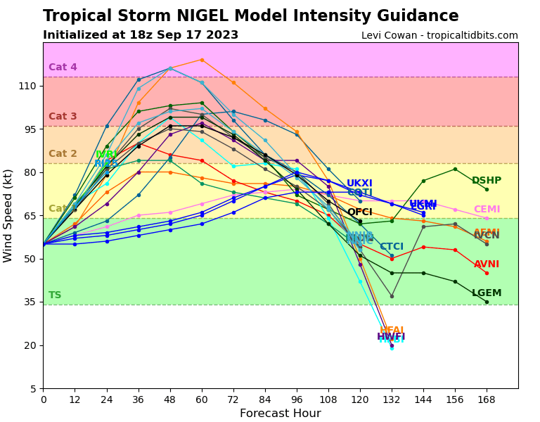
WalterWhite wrote:https://i.postimg.cc/W4sMh6R3/15-L-intensity-latest.png
With that spread, I like the NHC’s prediction of a 115 - 120 mph peak. Small chance of briefly hitting Cat 4 but not likely in my opinion.
0 likes
Fran '96, Georges '98, Gordon '00, Gabrielle '01, Charley '04, Frances '04, Jeanne '04, Barry '07, Fay '08, Debby '12, Matthew '16, Emily '17, Irma '17, Michael ‘18, Elsa ‘21, Fred ‘21, Mindy ‘21, Nicole ‘22, Idalia ‘23, Debby ‘24, Helene ‘24
-
cycloneye

- Admin

- Posts: 149843
- Age: 69
- Joined: Thu Oct 10, 2002 10:54 am
- Location: San Juan, Puerto Rico
Re: ATL: NIGEL - Models
None of the models including HAFS A-B, HWRF and the oficial NHC track go up to cat 3.

0 likes
Visit the Caribbean-Central America Weather Thread where you can find at first post web cams,radars
and observations from Caribbean basin members Click Here
and observations from Caribbean basin members Click Here
Re: ATL: NIGEL - Models
cycloneye wrote:None of the models including HAFS A-B, HWRF and the oficial NHC track go up to cat 3.
https://i.imgur.com/Ivm4Avg.png
I believe the OFCL line is just an interpolation based on the current BT initial intensity and NHC's forecast increments from the last advisory cycle. They'll probably lower the intensity forecast in 30 minutes, though.
1 likes
TC naming lists: retirements and intensity
Most aggressive Advisory #1's in North Atlantic (cr. kevin for starting the list)
Most aggressive Advisory #1's in North Atlantic (cr. kevin for starting the list)
Who is online
Users browsing this forum: No registered users and 38 guests