Moderator: S2k Moderators


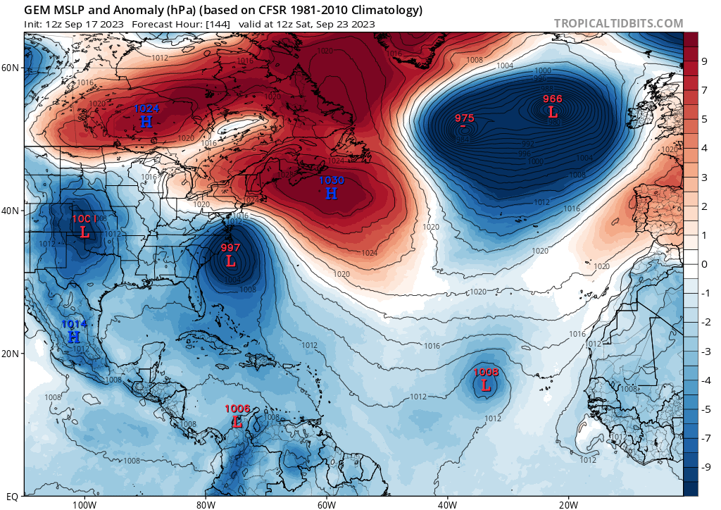
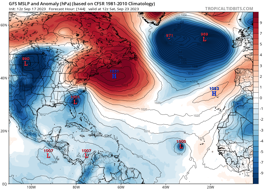
WalterWhite wrote:Both the CMC and the GFS show future Ophelia (the area of low pressure near Cape Verde) and future Philippe (the area of low pressure near the Carolinas) forming later this month.
https://i.postimg.cc/SK8hF4R0/gem-mslpa-atl-25.png
https://i.postimg.cc/nhXx2Bth/gfs-mslpa-atl-25.png


Ianswfl wrote:12z gefs giving off more western Caribbean signals including a SWFL hurricane strike from CAG.
Ianswfl wrote:jlauderdal wrote:We need a seperate thread for SWFL.
Do you think enough signals are there yet for a thread for a possible end of September cag threat though?
SouthFLTropics wrote:Ianswfl wrote:12z gefs giving off more western Caribbean signals including a SWFL hurricane strike from CAG.
That 12z GEFS is giving off serious 1999 Irene vibes.
Sent from my iPhone using Tapatalk
240 is max we need to go and that is often a bridge to farIanswfl wrote:SouthFLTropics wrote:Ianswfl wrote:12z gefs giving off more western Caribbean signals including a SWFL hurricane strike from CAG.
That 12z GEFS is giving off serious 1999 Irene vibes.
Sent from my iPhone using Tapatalk
a few other members weaker and further north too. The 368 hr euro ensembles are not out yet, the 240hr one has a bunch of TD members in the carribean. With the pattern this year IMO the OCt and Nov Gulf threats will be Florida storms.
jlauderdal wrote:240 is max we need to go and that is often a bridge to farIanswfl wrote:SouthFLTropics wrote:That 12z GEFS is giving off serious 1999 Irene vibes.
Sent from my iPhone using Tapatalk
a few other members weaker and further north too. The 368 hr euro ensembles are not out yet, the 240hr one has a bunch of TD members in the carribean. With the pattern this year IMO the OCt and Nov Gulf threats will be Florida storms.


Ianswfl wrote:18z gefs has a cat2 into SWFL, a major into the Keys and south FL as well and some weak systems on it. These seem to originate from the Caribbean, not the wave coming off Africa. The cat2 seems to weaken at landfall, likely shear. But that major member into the Keys could be a monster. Not getting pushed back much so I'd say I'd expect stronger signals in future GEFS runs.


ThunderForce wrote:Ianswfl wrote:18z gefs has a cat2 into SWFL, a major into the Keys and south FL as well and some weak systems on it. These seem to originate from the Caribbean, not the wave coming off Africa. The cat2 seems to weaken at landfall, likely shear. But that major member into the Keys could be a monster. Not getting pushed back much so I'd say I'd expect stronger signals in future GEFS runs.
For the most part they haven't really shown much development until around the forecast hour 180 mark or later, which is usually about when the operational GFS starts getting into fantasy land and things can shift drastically from run to run. In fact, comparing 18z GEFS to the last run, sub-1000 development has been pushed back to roughly hour 204 whereas the last run (12z) had the first one form at forecast hour 186. The first sub-1000 I've seen in the current 18z GEFS run from that area and not from the current tropical wave pops in at about 06z Thursday. In total, I've counted roughly 3-4 members not related to the current tropical wave that go sub-1000 or so. For comparison, here is the 18z GEFS run from 14th of September compared to the current run.
https://i.imgur.com/gE14ytD.png
https://i.imgur.com/YZ9kOeb.png
Overall, the run on the 14th was more actually active than the current one is. This is around the time of season where CAGs start allowing storms to brew more easily in the western Caribbean and Gulf though, so it definitely needs to be watched.
Ianswfl wrote:ThunderForce wrote:Ianswfl wrote:18z gefs has a cat2 into SWFL, a major into the Keys and south FL as well and some weak systems on it. These seem to originate from the Caribbean, not the wave coming off Africa. The cat2 seems to weaken at landfall, likely shear. But that major member into the Keys could be a monster. Not getting pushed back much so I'd say I'd expect stronger signals in future GEFS runs.
For the most part they haven't really shown much development until around the forecast hour 180 mark or later, which is usually about when the operational GFS starts getting into fantasy land and things can shift drastically from run to run. In fact, comparing 18z GEFS to the last run, sub-1000 development has been pushed back to roughly hour 204 whereas the last run (12z) had the first one form at forecast hour 186. The first sub-1000 I've seen in the current 18z GEFS run from that area and not from the current tropical wave pops in at about 06z Thursday. In total, I've counted roughly 3-4 members not related to the current tropical wave that go sub-1000 or so. For comparison, here is the 18z GEFS run from 14th of September compared to the current run.
https://i.imgur.com/gE14ytD.png
https://i.imgur.com/YZ9kOeb.png
Overall, the run on the 14th was more actually active than the current one is. This is around the time of season where CAGs start allowing storms to brew more easily in the western Caribbean and Gulf though, so it definitely needs to be watched.
While the operational gfs shows nothing down there late in the run it does have lower than normal pressures in that area of the basin.
Anything that forms down there could be an eastern gulf threat due to the pattern. I suspect even Nov could be risky. The waters will still be over 80 most likely so if something does get sucked up it could still be strong. Even a mid nov storm sucked up into swfl with upper 70s waters wouldnt have much time to weaken enough if moving fast.
I suspect 10 years from now November will be more like a October for hurricanes due to warmer waters in the Gulf.
ThunderForce wrote:Ianswfl wrote:ThunderForce wrote:For the most part they haven't really shown much development until around the forecast hour 180 mark or later, which is usually about when the operational GFS starts getting into fantasy land and things can shift drastically from run to run. In fact, comparing 18z GEFS to the last run, sub-1000 development has been pushed back to roughly hour 204 whereas the last run (12z) had the first one form at forecast hour 186. The first sub-1000 I've seen in the current 18z GEFS run from that area and not from the current tropical wave pops in at about 06z Thursday. In total, I've counted roughly 3-4 members not related to the current tropical wave that go sub-1000 or so. For comparison, here is the 18z GEFS run from 14th of September compared to the current run.
https://i.imgur.com/gE14ytD.png
https://i.imgur.com/YZ9kOeb.png
Overall, the run on the 14th was more actually active than the current one is. This is around the time of season where CAGs start allowing storms to brew more easily in the western Caribbean and Gulf though, so it definitely needs to be watched.
While the operational gfs shows nothing down there late in the run it does have lower than normal pressures in that area of the basin.
Anything that forms down there could be an eastern gulf threat due to the pattern. I suspect even Nov could be risky. The waters will still be over 80 most likely so if something does get sucked up it could still be strong. Even a mid nov storm sucked up into swfl with upper 70s waters wouldnt have much time to weaken enough if moving fast.
I suspect 10 years from now November will be more like a October for hurricanes due to warmer waters in the Gulf.
That's the thing though, anything after forecast hour 180/200 on the operational GFS should be taken with a grain of salt because of how wildly things can fluctuate between them. Compare how the current tropical wave storm was way further west before recurving in the last 12z run compared to the current 18z one. The further into the run you get, the less accurate the forecast is. They can be useful for certain data and trends though, of course.
I know how problematic Gulf storms are considering I directly went through Michael back in 2018 and had my entire hometown nearly wiped out. Letting my guard down is the last thing I plan on doing.
Ianswfl wrote:ThunderForce wrote:Ianswfl wrote:
While the operational gfs shows nothing down there late in the run it does have lower than normal pressures in that area of the basin.
Anything that forms down there could be an eastern gulf threat due to the pattern. I suspect even Nov could be risky. The waters will still be over 80 most likely so if something does get sucked up it could still be strong. Even a mid nov storm sucked up into swfl with upper 70s waters wouldnt have much time to weaken enough if moving fast.
I suspect 10 years from now November will be more like a October for hurricanes due to warmer waters in the Gulf.
That's the thing though, anything after forecast hour 180/200 on the operational GFS should be taken with a grain of salt because of how wildly things can fluctuate between them. Compare how the current tropical wave storm was way further west before recurving in the last 12z run compared to the current 18z one. The further into the run you get, the less accurate the forecast is. They can be useful for certain data and trends though, of course.
I know how problematic Gulf storms are considering I directly went through Michael back in 2018 and had my entire hometown nearly wiped out. Letting my guard down is the last thing I plan on doing.
The GFS and ensembles did snuff out Ian and Idalia though long range. Of course landfall points vary each run but they give hints something will form. Seems last year and this year less phantom storms on the models.
Users browsing this forum: pepecool20 and 236 guests
