2023 Global Model Runs Discussion (Out thru day 16)
Moderator: S2k Moderators
Forum rules

The posts in this forum are NOT official forecasts and should not be used as such. They are just the opinion of the poster and may or may not be backed by sound meteorological data. They are NOT endorsed by any professional institution or STORM2K. For official information, please refer to products from the National Hurricane Center and National Weather Service.
-
ThunderForce

- Tropical Storm

- Posts: 208
- Age: 26
- Joined: Tue Sep 27, 2022 6:20 pm
- Location: Calhoun County, Florida
Re: 2023 Global Model Runs Discussion (Out thru day 16)
Is there any particular reason the Euro ensembles show little to nothing in that area?
0 likes
Please refer to the NWS, NHC, SPC or a professional meteorologist for information and decision making during storms.
-
AutoPenalti
- Category 5

- Posts: 4091
- Age: 29
- Joined: Mon Aug 17, 2015 4:16 pm
- Location: Ft. Lauderdale, Florida
Re: 2023 Global Model Runs Discussion (Out thru day 16)
ThunderForce wrote:Is there any particular reason the Euro ensembles show little to nothing in that area?
Could be a fantasy cane.
0 likes
The posts in this forum are NOT official forecasts and should not be used as such. They are just the opinion of the poster and may or may not be backed by sound meteorological data. They are NOT endorsed by any professional institution or STORM2K. For official information, please refer to products from the NHC and NWS.
Model Runs Cheat Sheet:
GFS (5:30 AM/PM, 11:30 AM/PM)
HWRF, GFDL, UKMET, NAVGEM (6:30-8:00 AM/PM, 12:30-2:00 AM/PM)
ECMWF (1:45 AM/PM)
TCVN is a weighted averaged
Re: 2023 Global Model Runs Discussion (Out thru day 16)
AutoPenalti wrote:ThunderForce wrote:Is there any particular reason the Euro ensembles show little to nothing in that area?
Could be a fantasy cane.
Seems we've had this with other storms lately. Either the euro or GFS doesn't show it. I like to use ensembles to see a pattern. When it's multiple runs of the GFS ensembles showing it it perks me up a bit. This run the operational GFS finally shows a weak TD so it might be trending towards the ensembles.
There will be a lot of moisutre in the western ATL next week. A wet and humid pattern returns here to SWFL too.
0 likes
-
ThunderForce
- Tropical Storm
- Posts: 208
- Age: 26
- Joined: Tue Sep 27, 2022 6:20 pm
- Location: Calhoun County, Florida
Re: 2023 Global Model Runs Discussion (Out thru day 16)
Ianswfl wrote:AutoPenalti wrote:ThunderForce wrote:Is there any particular reason the Euro ensembles show little to nothing in that area?
Could be a fantasy cane.
Seems we've had this with other storms lately. Either the euro or GFS doesn't show it. I like to use ensembles to see a pattern. When it's multiple runs of the GFS ensembles showing it it perks me up a bit. This run the operational GFS finally shows a weak TD so it might be trending towards the ensembles.
There will be a lot of moisutre in the western ATL next week. A wet and humid pattern returns here to SWFL too.
Personally I'd be happy with no more landfalls anywhere for the rest of the season, so I'm hoping the current Euro ensembles and model are right this time around.
0 likes
Please refer to the NWS, NHC, SPC or a professional meteorologist for information and decision making during storms.
-
toad strangler

- S2K Supporter

- Posts: 4546
- Joined: Sun Jul 28, 2013 3:09 pm
- Location: Earth
- Contact:
Re: 2023 Global Model Runs Discussion (Out thru day 16)
Ianswfl wrote:!8z gfs stronger. Now shows a weak sheared TD forming late next week. Then at end of the run develops a tropical storm down there as well.
The 18z gefs is running. Ensembles much more active 18z so far for the first possible system and stronger too. One of the members takes a cat3 right into Tampa Bay slowly like Ian only further north. With the 18z showing a brief sheared TD finally it seems the operational gradually caving to the ensembles.
https://www.tropicaltidbits.com/analysis/models/gfs-ens/2023092318/gfs-ememb_lowlocs_watl_38.png
https://www.tropicaltidbits.com/analysis/models/gfs-ens/2023092318/gfs-ememb_lowlocs_watl_31.png
I’m always watching until the end of October but those signals from the GFS are weak sauce IMO.
It will be getting late very quickly soon for the CONUS.
1 likes
My Weather Station
https://www.wunderground.com/dashboard/pws/KFLPORTS603
https://www.wunderground.com/dashboard/pws/KFLPORTS603
-
SFLcane

- S2K Supporter
- Posts: 10281
- Age: 48
- Joined: Sat Jun 05, 2010 1:44 pm
- Location: Lake Worth Florida
Re: 2023 Global Model Runs Discussion (Out thru day 16)
toad strangler wrote:Ianswfl wrote:!8z gfs stronger. Now shows a weak sheared TD forming late next week. Then at end of the run develops a tropical storm down there as well.
The 18z gefs is running. Ensembles much more active 18z so far for the first possible system and stronger too. One of the members takes a cat3 right into Tampa Bay slowly like Ian only further north. With the 18z showing a brief sheared TD finally it seems the operational gradually caving to the ensembles.
https://www.tropicaltidbits.com/analysis/models/gfs-ens/2023092318/gfs-ememb_lowlocs_watl_38.png
https://www.tropicaltidbits.com/analysis/models/gfs-ens/2023092318/gfs-ememb_lowlocs_watl_31.png
I’m always watching until the end of October but those signals from the GFS are weak sauce IMO.
It will be getting late very quickly soon for the CONUS.
More hurricanes showering up on the 18z gefs .Surely something to watch for now waters are extra warm.

0 likes
-
CFLHurricane

- Category 1

- Posts: 350
- Joined: Thu Mar 27, 2014 5:56 pm
- Location: Floriduh
Re: 2023 Global Model Runs Discussion (Out thru day 16)
SFLcane wrote:toad strangler wrote:Ianswfl wrote:!8z gfs stronger. Now shows a weak sheared TD forming late next week. Then at end of the run develops a tropical storm down there as well.
The 18z gefs is running. Ensembles much more active 18z so far for the first possible system and stronger too. One of the members takes a cat3 right into Tampa Bay slowly like Ian only further north. With the 18z showing a brief sheared TD finally it seems the operational gradually caving to the ensembles.
https://www.tropicaltidbits.com/analysis/models/gfs-ens/2023092318/gfs-ememb_lowlocs_watl_38.png
https://www.tropicaltidbits.com/analysis/models/gfs-ens/2023092318/gfs-ememb_lowlocs_watl_31.png
I’m always watching until the end of October but those signals from the GFS are weak sauce IMO.
It will be getting late very quickly soon for the CONUS.
More hurricanes showering up on the 18z gefs .Surely something to watch for now waters are extra warm.
https://i.postimg.cc/3R1SL9Vs/IMG-7641.jpg
I’m not convinced with the models vacillating between feast and famine so close to October. We’ve got about two weeks left for the models to show a consistent signal on something before I’m going into off-season mode here on the Space Coast.
2 likes
I'm not a meteorologist, but I did stay at a motel 8.
-
floridasun
- Tropical Storm
- Posts: 245
- Joined: Tue Sep 14, 2021 3:59 pm
Re: 2023 Global Model Runs Discussion (Out thru day 16)
No hurr on Oct 1 wife birthday weekend
2 likes
Re: 2023 Global Model Runs Discussion (Out thru day 16)
Ianswfl wrote:!8z gfs stronger. Now shows a weak sheared TD forming late next week. Then at end of the run develops a tropical storm down there as well.
The 18z gefs is running. Ensembles much more active 18z so far for the first possible system and stronger too. One of the members takes a cat3 right into Tampa Bay slowly like Ian only further north. With the 18z showing a brief sheared TD finally it seems the operational gradually caving to the ensembles.
https://www.tropicaltidbits.com/analysis/models/gfs-ens/2023092318/gfs-ememb_lowlocs_watl_38.png
https://www.tropicaltidbits.com/analysis/models/gfs-ens/2023092318/gfs-ememb_lowlocs_watl_31.png
Just like the 12Z, this run has 5 moderate TS to H members out of 31.
This bears watching.
2 likes
Personal Forecast Disclaimer:
The posts in this forum are NOT official forecasts and should not be used as such. They are just the opinion of the poster and may or may not be backed by sound meteorological data. They are NOT endorsed by any professional institution or storm2k.org. For official information, please refer to the NHC and NWS products.
The posts in this forum are NOT official forecasts and should not be used as such. They are just the opinion of the poster and may or may not be backed by sound meteorological data. They are NOT endorsed by any professional institution or storm2k.org. For official information, please refer to the NHC and NWS products.
Re: 2023 Global Model Runs Discussion (Out thru day 16)
LarryWx wrote:Ianswfl wrote:!8z gfs stronger. Now shows a weak sheared TD forming late next week. Then at end of the run develops a tropical storm down there as well.
The 18z gefs is running. Ensembles much more active 18z so far for the first possible system and stronger too. One of the members takes a cat3 right into Tampa Bay slowly like Ian only further north. With the 18z showing a brief sheared TD finally it seems the operational gradually caving to the ensembles.
https://www.tropicaltidbits.com/analysis/models/gfs-ens/2023092318/gfs-ememb_lowlocs_watl_38.png
https://www.tropicaltidbits.com/analysis/models/gfs-ens/2023092318/gfs-ememb_lowlocs_watl_31.png
Just like the 12Z, this run has 5 moderate TS to H members out of 31.
This bears watching.
The operation at the very end also forms another TS down there. The ensembles at the end of the run kinda hints too at something that might form down there.
I wonder if oct will crank out CAGS like what's going on in the east atl right now! Well, not that many that's not possible.
0 likes

Re: 2023 Global Model Runs Discussion (Out thru day 16)
Well the Euro has something different with Phillepe and the storm behind. 

1 likes
The following post is NOT an official forecast and should not be used as such. It is just the opinion of the poster and may or may not be backed by sound meteorological data. It is NOT endorsed by any professional institution including storm2k.org For Official Information please refer to the NHC and NWS products.

Re: 2023 Global Model Runs Discussion (Out thru day 16)
Anyone else see the spin in the thunderstorms in the Gulf just west of Florida?
No real model support, however some of the mesoscale show a weak low forming, apparently there is already a broad area of low(er) pressure.
While chances are low of development, I would have say to say there's a chance.
No real model support, however some of the mesoscale show a weak low forming, apparently there is already a broad area of low(er) pressure.
While chances are low of development, I would have say to say there's a chance.
0 likes
-
gatorcane

- S2K Supporter
- Posts: 23708
- Age: 48
- Joined: Sun Mar 13, 2005 3:54 pm
- Location: Boca Raton, FL
Re: 2023 Global Model Runs Discussion (Out thru day 16)
The Gulf continues to be unfavorable due to strong wind shear and the Western Caribbean doesn’t look favorable either, according to the GFS. El Niño continues to exert its influence across the Western portions of the basin and could continue to do so into October limiting any significant development. Can’t rule out something trying to get going but there should be shear there and tracks east of Florida through Cuba would be favored with the pattern.
Last edited by gatorcane on Sun Sep 24, 2023 8:15 am, edited 1 time in total.
0 likes
-
WalterWhite

- Category 1
- Posts: 342
- Joined: Fri Mar 17, 2023 5:53 pm
Re: 2023 Global Model Runs Discussion (Out thru day 16)
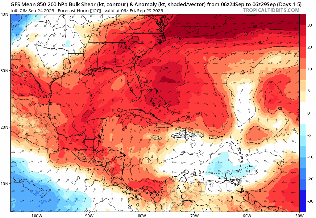
gatorcane wrote:The Gulf continues to be unfavorable due to strong wind shear and the Western Caribbean doesn’t look favorable either, according to the GFS. El Niño continues to exert its influence across the Western portions of the basin and could continue to do so into October limiting any significant development.
https://i.postimg.cc/HsMnSCSz/gfs-ashear-Mean-watl-fh120-384.gif
Shear forecasts are not very reliable.
1 likes
-
CourierPR

- Category 5
- Posts: 1336
- Age: 72
- Joined: Tue Aug 31, 2004 7:53 pm
- Location: Pompano Beach, Florida
Re: 2023 Global Model Runs Discussion (Out thru day 16)
gatorcane wrote:The Gulf continues to be unfavorable due to strong wind shear and the Western Caribbean doesn’t look favorable either, according to the GFS. El Niño continues to exert its influence across the Western portions of the basin and could continue to do so into October limiting any significant development. Can’t rule out something trying to get going but there should be shear there and tracks east of Florida through Cuba would be favored with the pattern.
https://i.postimg.cc/HsMnSCSz/gfs-ashear-Mean-watl-fh120-384.gif
Bastardi is looking for Gulf development later this week. I'll go with his well-educated opinion.
1 likes
Re: 2023 Global Model Runs Discussion (Out thru day 16)
CourierPR wrote:gatorcane wrote:The Gulf continues to be unfavorable due to strong wind shear and the Western Caribbean doesn’t look favorable either, according to the GFS. El Niño continues to exert its influence across the Western portions of the basin and could continue to do so into October limiting any significant development. Can’t rule out something trying to get going but there should be shear there and tracks east of Florida through Cuba would be favored with the pattern.
https://i.postimg.cc/HsMnSCSz/gfs-ashear-Mean-watl-fh120-384.gif
Bastardi is looking for Gulf development later this week. I'll go with his well-educated opinion.
Ensembles still as of 06z show a hurricane hit swfl either sept 30th or next sunday. One member 971 mb, strong cat2 and another member strong cat1
0 likes
-
ThunderForce
- Tropical Storm
- Posts: 208
- Age: 26
- Joined: Tue Sep 27, 2022 6:20 pm
- Location: Calhoun County, Florida
Re: 2023 Global Model Runs Discussion (Out thru day 16)
At this point either the Euro or the GFS is going to end up having to cave to the other eventually, especially since it's not that far out. Both models' ensembles seem pretty different not even 120 hours out.


0 likes
Please refer to the NWS, NHC, SPC or a professional meteorologist for information and decision making during storms.
-
SFLcane
- S2K Supporter
- Posts: 10281
- Age: 48
- Joined: Sat Jun 05, 2010 1:44 pm
- Location: Lake Worth Florida
Re: 2023 Global Model Runs Discussion (Out thru day 16)
Looks like an epac storm incoming potentially GEFS backed away from the Caribbean.
0 likes
Re: 2023 Global Model Runs Discussion (Out thru day 16)
SFLcane wrote:Looks like an epac storm incoming potentially GEFS backed away from the Caribbean.
So we know something might be down there. Question is where.
0 likes
-
Category5Kaiju

- Category 5
- Posts: 4346
- Joined: Thu Dec 24, 2020 12:45 pm
- Location: Seattle during the summer, Phoenix during the winter
Re: 2023 Global Model Runs Discussion (Out thru day 16)
Most recent CMC run seems to suggest two more storms forming (including the 10/40 AOI (91L) and another one right off the Eastern Seaboard) in the coming week or so. 
0 likes
Unless explicitly stated, all information in my posts is based on my own opinions and observations. Tropical storms and hurricanes can be extremely dangerous. Refer to an accredited weather research agency or meteorologist if you need to make serious decisions regarding an approaching storm.
Who is online
Users browsing this forum: USTropics and 151 guests