ATL: PHILIPPE - Models
Moderator: S2k Moderators
-
Iceresistance

- Category 5

- Posts: 9610
- Age: 22
- Joined: Sat Oct 10, 2020 9:45 am
- Location: Tecumseh, OK/Norman, OK
ATL: PHILIPPE - Models
Only model runs here
0 likes
Bill 2015 & Beta 2020
Winter 2020-2021
All observations are in Tecumseh, OK unless otherwise noted.
Winter posts are focused mainly for Oklahoma & Texas.
Take any of my forecasts with a grain of salt, refer to the NWS, SPC, and NHC for official information
Never say Never with weather! Because ANYTHING is possible!
Winter 2020-2021
All observations are in Tecumseh, OK unless otherwise noted.
Winter posts are focused mainly for Oklahoma & Texas.
Take any of my forecasts with a grain of salt, refer to the NWS, SPC, and NHC for official information
Never say Never with weather! Because ANYTHING is possible!
-
cycloneye

- Admin

- Posts: 149843
- Age: 69
- Joined: Thu Oct 10, 2002 10:54 am
- Location: San Juan, Puerto Rico
Re: ATL: INVEST 90L - Models
12z Euro is all recurve.

1 likes
Visit the Caribbean-Central America Weather Thread where you can find at first post web cams,radars
and observations from Caribbean basin members Click Here
and observations from Caribbean basin members Click Here
-
PavelGaborik10
- Category 1

- Posts: 472
- Joined: Tue Sep 04, 2018 3:23 pm
Re: ATL: INVEST 90L - Models
Very early but early signs certainly pointing to another recurve OTS
0 likes
-
PTrackerLA

- Category 5
- Posts: 5281
- Age: 42
- Joined: Thu Oct 10, 2002 8:40 pm
- Location: Lafayette, LA
-
cycloneye
- Admin
- Posts: 149843
- Age: 69
- Joined: Thu Oct 10, 2002 10:54 am
- Location: San Juan, Puerto Rico
Re: ATL: INVEST 90L - Models


0 likes
Visit the Caribbean-Central America Weather Thread where you can find at first post web cams,radars
and observations from Caribbean basin members Click Here
and observations from Caribbean basin members Click Here
-
cycloneye
- Admin
- Posts: 149843
- Age: 69
- Joined: Thu Oct 10, 2002 10:54 am
- Location: San Juan, Puerto Rico
Re: ATL: INVEST 90L - Models
12z GFS continues to recurve sharply well away from the northern Leewards.

1 likes
Visit the Caribbean-Central America Weather Thread where you can find at first post web cams,radars
and observations from Caribbean basin members Click Here
and observations from Caribbean basin members Click Here
-
cycloneye
- Admin
- Posts: 149843
- Age: 69
- Joined: Thu Oct 10, 2002 10:54 am
- Location: San Juan, Puerto Rico
Re: ATL: INVEST 90L - Models
12z CMC with the same recurving.

0 likes
Visit the Caribbean-Central America Weather Thread where you can find at first post web cams,radars
and observations from Caribbean basin members Click Here
and observations from Caribbean basin members Click Here
-
cycloneye
- Admin
- Posts: 149843
- Age: 69
- Joined: Thu Oct 10, 2002 10:54 am
- Location: San Juan, Puerto Rico
Re: ATL: INVEST 90L - Models
12z UKMET the same with the recurving.
TROPICAL DEPRESSION 90L ANALYSED POSITION : 15.3N 33.3W
ATCF IDENTIFIER : AL902023
LEAD CENTRAL MAXIMUM WIND
VERIFYING TIME TIME POSITION PRESSURE (MB) SPEED (KNOTS)
-------------- ---- -------- ------------- -------------
1200UTC 22.09.2023 0 15.3N 33.3W 1010 26
0000UTC 23.09.2023 12 15.6N 36.4W 1010 27
1200UTC 23.09.2023 24 16.1N 39.4W 1010 28
0000UTC 24.09.2023 36 15.9N 42.2W 1010 28
1200UTC 24.09.2023 48 16.4N 45.0W 1010 27
0000UTC 25.09.2023 60 16.9N 47.8W 1010 28
1200UTC 25.09.2023 72 17.2N 50.2W 1009 28
0000UTC 26.09.2023 84 17.5N 52.2W 1009 31
1200UTC 26.09.2023 96 17.8N 53.7W 1007 33
0000UTC 27.09.2023 108 18.0N 54.6W 1005 37
1200UTC 27.09.2023 120 18.9N 55.8W 1004 42
0000UTC 28.09.2023 132 19.6N 57.4W 1002 44
1200UTC 28.09.2023 144 21.1N 57.9W 1002 37
0000UTC 29.09.2023 156 22.5N 57.7W 1001 34
1200UTC 29.09.2023 168 23.8N 57.7W 1001 35
0 likes
Visit the Caribbean-Central America Weather Thread where you can find at first post web cams,radars
and observations from Caribbean basin members Click Here
and observations from Caribbean basin members Click Here
-
cycloneye
- Admin
- Posts: 149843
- Age: 69
- Joined: Thu Oct 10, 2002 10:54 am
- Location: San Juan, Puerto Rico
Re: ATL: INVEST 90L - Models
The 12z ECMWF has the same recurving scenario.

0 likes
Visit the Caribbean-Central America Weather Thread where you can find at first post web cams,radars
and observations from Caribbean basin members Click Here
and observations from Caribbean basin members Click Here
-
cycloneye
- Admin
- Posts: 149843
- Age: 69
- Joined: Thu Oct 10, 2002 10:54 am
- Location: San Juan, Puerto Rico
Re: ATL: INVEST 90L - Models
The consensus of recurving continues strong.

0 likes
Visit the Caribbean-Central America Weather Thread where you can find at first post web cams,radars
and observations from Caribbean basin members Click Here
and observations from Caribbean basin members Click Here
-
cycloneye
- Admin
- Posts: 149843
- Age: 69
- Joined: Thu Oct 10, 2002 10:54 am
- Location: San Juan, Puerto Rico
Re: ATL: INVEST 90L - Models
Models are not as bullish on this 12z run.

0 likes
Visit the Caribbean-Central America Weather Thread where you can find at first post web cams,radars
and observations from Caribbean basin members Click Here
and observations from Caribbean basin members Click Here
-
cycloneye
- Admin
- Posts: 149843
- Age: 69
- Joined: Thu Oct 10, 2002 10:54 am
- Location: San Juan, Puerto Rico
Re: ATL: SEVENTEEN - Models
12z GFS not as bullish in 5 days, but later it has it stronger north of 30N.

0 likes
Visit the Caribbean-Central America Weather Thread where you can find at first post web cams,radars
and observations from Caribbean basin members Click Here
and observations from Caribbean basin members Click Here

Re: ATL: PHILIPPE - Models
What is the Euro doing no recurve dives under the ridge  Need to see confirmation on next run.

0 likes
The following post is NOT an official forecast and should not be used as such. It is just the opinion of the poster and may or may not be backed by sound meteorological data. It is NOT endorsed by any professional institution including storm2k.org For Official Information please refer to the NHC and NWS products.
Re: ATL: PHILIPPE - Models
blp wrote:What is the Euro doing no recurve dives under the ridge
https://i.ibb.co/Qd32cDg/ec-fast-uv850-vort-atl-fh48-216.gif
Not much left though and dives towards Hispaniola. Now if it's stronger and stays just offshore and heads west then it's an issue.
Ensembles are going to be interesting
0 likes

Re: ATL: PHILIPPE - Models
Ianswfl wrote:blp wrote:What is the Euro doing no recurve dives under the ridge
https://i.ibb.co/Qd32cDg/ec-fast-uv850-vort-atl-fh48-216.gif
Not much left though and dives towards Hispaniola. Now if it's stronger and stays just offshore and heads west then it's an issue.
Ensembles are going to be interesting
Euro ens says the op is an outlier and has hardly any threatening members to the CONUS or any land for that matter through 360 from any TC. However, I still think a potential home brew via ridge over troubled waters setup part 2 (Ophelia was part 1) bears watching for the W Car, GOM, or SW Atlantic.
0 likes
Personal Forecast Disclaimer:
The posts in this forum are NOT official forecasts and should not be used as such. They are just the opinion of the poster and may or may not be backed by sound meteorological data. They are NOT endorsed by any professional institution or storm2k.org. For official information, please refer to the NHC and NWS products.
The posts in this forum are NOT official forecasts and should not be used as such. They are just the opinion of the poster and may or may not be backed by sound meteorological data. They are NOT endorsed by any professional institution or storm2k.org. For official information, please refer to the NHC and NWS products.


Re: ATL: PHILIPPE - Models
LarryWx wrote:Ianswfl wrote:blp wrote:What is the Euro doing no recurve dives under the ridge
https://i.ibb.co/Qd32cDg/ec-fast-uv850-vort-atl-fh48-216.gif
Not much left though and dives towards Hispaniola. Now if it's stronger and stays just offshore and heads west then it's an issue.
Ensembles are going to be interesting
Euro ens says the op is an outlier and has hardly any threatening members to the CONUS or any land for that matter through 360 from any TC. However, I still think a potential home brew via ridge over troubled waters setup part 2 (Ophelia was part 1) bears watching for the W Car, GOM, or SW Atlantic.
Uncertainty grows after that point, with the
track seemingly dependent on the intensity. A stronger system
would probably turn northward, like the GFS/HWRF/HMON models, while
a weaker one, like the UKMET/ECMWF solutions, would take a left
turn under the low-level subtropical ridge.
track seemingly dependent on the intensity. A stronger system
would probably turn northward, like the GFS/HWRF/HMON models, while
a weaker one, like the UKMET/ECMWF solutions, would take a left
turn under the low-level subtropical ridge.
0 likes
TC naming lists: retirements and intensity
Most aggressive Advisory #1's in North Atlantic (cr. kevin for starting the list)
Most aggressive Advisory #1's in North Atlantic (cr. kevin for starting the list)
-
WalterWhite

- Category 1
- Posts: 342
- Joined: Fri Mar 17, 2023 5:53 pm
Re: ATL: PHILIPPE - Models
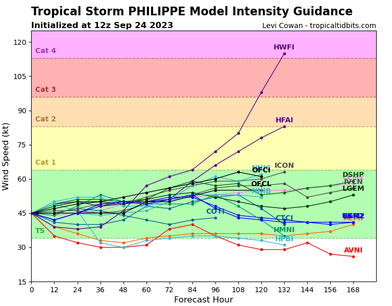
I would not call that "believing in Philippe", especially given that it does not take the storm to major hurricane status.
0 likes
Re: ATL: PHILIPPE - Models
WalterWhite wrote:
I would not call that "believing in Philippe", especially given that it does not take the storm to major hurricane status.
It does count when most intensity guidance and the NHC forecast don't even make this a hurricane.
1 likes
TC naming lists: retirements and intensity
Most aggressive Advisory #1's in North Atlantic (cr. kevin for starting the list)
Most aggressive Advisory #1's in North Atlantic (cr. kevin for starting the list)
-
cycloneye
- Admin
- Posts: 149843
- Age: 69
- Joined: Thu Oct 10, 2002 10:54 am
- Location: San Juan, Puerto Rico
Re: ATL: PHILIPPE - Models
12z GFS a little bit more stronger.

0 likes
Visit the Caribbean-Central America Weather Thread where you can find at first post web cams,radars
and observations from Caribbean basin members Click Here
and observations from Caribbean basin members Click Here
Who is online
Users browsing this forum: No registered users and 33 guests