ATL: RINA - Remnants - Discussion
Moderator: S2k Moderators
-
floridasun
- Tropical Storm

- Posts: 245
- Joined: Tue Sep 14, 2021 3:59 pm
-
Sciencerocks
- Category 5

- Posts: 10193
- Age: 40
- Joined: Thu Jul 06, 2017 1:51 am


Re: ATL: INVEST 91L - Discussion
2AM:
Central Tropical Atlantic (AL91):
Showers and thunderstorms have changed little in organization in
association with an area of low pressure located roughly halfway
between the Cabo Verde Islands and the Lesser Antilles.
Environmental conditions are forecast to be conducive for
development, as long as this system remains far enough removed from
Tropical Storm Philippe to its west. A tropical depression or storm
is expected to form in the next day or so while the system moves
northwestward across the central tropical Atlantic. Additional
information on this system, including gale warnings, can be found in
High Seas Forecasts issued by the National Weather Service.
* Formation chance through 48 hours...high...90 percent.
* Formation chance through 7 days...high...90 percent.
0 likes
-
WalterWhite

- Category 1

- Posts: 342
- Joined: Fri Mar 17, 2023 5:53 pm
-
floridasun
- Tropical Storm
- Posts: 245
- Joined: Tue Sep 14, 2021 3:59 pm
Re: ATL: INVEST 91L - Discussion
WalterWhite wrote:91L has been a disappointment so far.
Because philippe want take over 91l
0 likes
Re: ATL: INVEST 91L - Discussion
8AM:
Central Tropical Atlantic (AL91):
Showers and thunderstorms continue to show signs of organization
in association with an area of low pressure located roughly halfway
between the Cabo Verde Islands and the Lesser Antilles.
Environmental conditions are forecast to be conducive for
development, as long as this system remains far enough removed from
Tropical Storm Philippe to its west. A tropical depression or storm
is expected to form later today or on Friday while the system moves
northwestward across the central tropical Atlantic. Additional
information on this system, including gale warnings, can be found in
High Seas Forecasts issued by the National Weather Service.
* Formation chance through 48 hours...high...90 percent.
* Formation chance through 7 days...high...90 percent.
0 likes
-
cycloneye

- Admin

- Posts: 149702
- Age: 69
- Joined: Thu Oct 10, 2002 10:54 am
- Location: San Juan, Puerto Rico
Re: ATL: INVEST 91L - Discussion
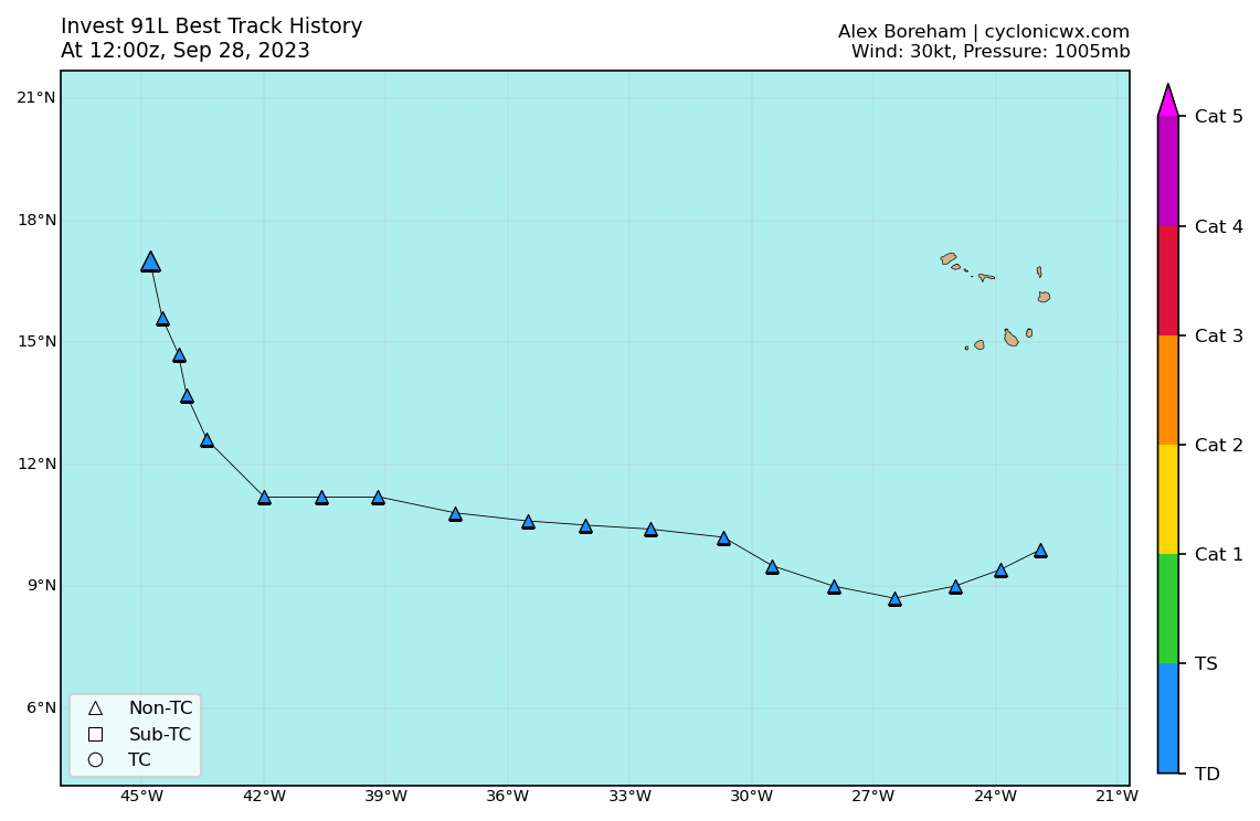
AL, 91, 2023092812, , BEST, 0, 170N, 448W, 30, 1005, LO
1 likes
Visit the Caribbean-Central America Weather Thread where you can find at first post web cams,radars
and observations from Caribbean basin members Click Here
and observations from Caribbean basin members Click Here
Re: ATL: INVEST 91L - Discussion
cycloneye wrote:AL, 91, 2023092812, , BEST, 0, 170N, 448W, 30, 1005, LO
There's been a significant change in 91L's trajectory over the last 24 hours or so.
I think it's mainly due to the close proximity of Philippe.
0 likes
Re: ATL: INVEST 91L - Discussion

2 likes
-
Sciencerocks
- Category 5
- Posts: 10193
- Age: 40
- Joined: Thu Jul 06, 2017 1:51 am
Re: ATL: INVEST 91L - Discussion
AL, 18, 2023092812, , BEST, 0, 170N, 448W, 30, 1005, LO, 34, NEQ, 0, 0, 0, 0, 1011, 160, 60, 0, 0, L, 0, , 0, 0, EIGHTEEN, S, 0, , 0, 0, 0, 0, genesis-num, 034, TRANSITIONED, alC12023 to al182023,
2 likes
-
Sciencerocks
- Category 5
- Posts: 10193
- Age: 40
- Joined: Thu Jul 06, 2017 1:51 am
-
Sciencerocks
- Category 5
- Posts: 10193
- Age: 40
- Joined: Thu Jul 06, 2017 1:51 am

-
Extratropical94

- Professional-Met

- Posts: 3545
- Age: 31
- Joined: Wed Oct 20, 2010 6:36 am
- Location: Hamburg, Germany
- Contact:
Re: ATL: INVEST 91L - Discussion
Sciencerocks wrote:https://twitter.com/AlanSevere/status/1707397396978700674
BT has been revised to 35kts. Good chance of seeing Rina in a couple minutes.
AL, 18, 2023092812, , BEST, 0, 170N, 448W, 35, 1005, TS
3 likes
54° 11' 59'' N, 9° 9' 20'' E
Boomer Sooner!
Go Broncos! Go Cards!
Clinching counties, one at a time: https://mob-rule.com/user-gifs/USA/xtrp94.gif
- Daniel
Boomer Sooner!
Go Broncos! Go Cards!
Clinching counties, one at a time: https://mob-rule.com/user-gifs/USA/xtrp94.gif
- Daniel
-
HurricaneEnzo

- Category 2

- Posts: 744
- Joined: Wed Mar 14, 2018 12:18 pm
- Location: Newport, NC (Hurricane Alley)
Re: ATL: INVEST 91L - Discussion
Phillippe has put up a good fight but it looks like future Rina is starting to gain the upper hand and is about to have Phil for a snack. That is based on nothing scientific just the way this big conglomeration is looking on satellite lol.
0 likes
Bertha 96' - Fran 96' - Bonnie 98' - Dennis 99' - Floyd 99' - Isabel 03' - Alex 04' - Ophelia 05' - Irene 11' - Arthur 14' - Matthew 16' - Florence 18' - Dorian 19' - Isaias 20' (countless other tropical storms and Hurricane swipes)
I am not a Professional Met just an enthusiast. Get your weather forecasts from the Pros!
I am not a Professional Met just an enthusiast. Get your weather forecasts from the Pros!
-
Iceresistance

- Category 5
- Posts: 9605
- Age: 22
- Joined: Sat Oct 10, 2020 9:45 am
- Location: Tecumseh, OK/Norman, OK
Re: ATL: INVEST 91L - Discussion
Just noticed the title being TD 18, is it official?
0 likes
Bill 2015 & Beta 2020
Winter 2020-2021
All observations are in Tecumseh, OK unless otherwise noted.
Winter posts are focused mainly for Oklahoma & Texas.
Take any of my forecasts with a grain of salt, refer to the NWS, SPC, and NHC for official information
Never say Never with weather! Because ANYTHING is possible!
Winter 2020-2021
All observations are in Tecumseh, OK unless otherwise noted.
Winter posts are focused mainly for Oklahoma & Texas.
Take any of my forecasts with a grain of salt, refer to the NWS, SPC, and NHC for official information
Never say Never with weather! Because ANYTHING is possible!
-
AnnularCane

- S2K Supporter

- Posts: 2964
- Joined: Thu Jun 08, 2006 9:18 am
- Location: Wytheville, VA
Re: ATL: RINA - Tropical Storm - Discussion
Apparently they referred to it as Rina in Philippe's discussion.
0 likes
"But it never rained rain. It never snowed snow. And it never blew just wind. It rained things like soup and juice. It snowed mashed potatoes and green peas. And sometimes the wind blew in storms of hamburgers." -- Judi Barrett, Cloudy with a Chance of Meatballs
-
ElectricStorm

- Category 5
- Posts: 5153
- Age: 25
- Joined: Tue Aug 13, 2019 11:23 pm
- Location: Norman, OK
Re: ATL: RINA - Tropical Storm - Discussion
Iceresistance wrote:Just noticed the title being TD 18, is it official?
Technically not official yet, but it should be in the next 10min or so
0 likes
B.S Meteorology, University of Oklahoma '25
Please refer to the NHC, NWS, or SPC for official information.
Please refer to the NHC, NWS, or SPC for official information.
-
ElectricStorm
- Category 5
- Posts: 5153
- Age: 25
- Joined: Tue Aug 13, 2019 11:23 pm
- Location: Norman, OK
Re: ATL: RINA - Tropical Storm - Discussion
AnnularCane wrote:Apparently they referred to it as Rina in Philippe's discussion.
Yep
The track forecast is challenging, in part due to Philippe's close proximity
to newly formed Tropical Storm Rina.
to newly formed Tropical Storm Rina.
0 likes
B.S Meteorology, University of Oklahoma '25
Please refer to the NHC, NWS, or SPC for official information.
Please refer to the NHC, NWS, or SPC for official information.
Who is online
Users browsing this forum: No registered users and 59 guests