If Invest 91L develops into Rina before the end of the month, that would bring the season to 18 storms, 6 hurricanes, and 3 major hurricanes. If 91L becomes a major hurricane, that would bring the season to 18 storms, 7 hurricanes, and 4 major hurricanes. This would put 2023 only behind 2020 and 2021 and equal to 2005 in terms of storm count by the end of September. What happens next all comes down to how the late season performs. The big question will be whether the late season of 2023 performs similarly to 2005, 2020, or 2021.
1) A 2005-esque late season (10 storms, 5 hurricanes, and 2 major hurricanes): While most of these storms are weak, some hurricanes and a few major hurricanes (notably Wilma) form. This combines "quantity" and "quality".
2) A 2020-esque late season (7 storms, 6 hurricanes, and 5 major hurricanes): While there are fewer storms in this late season than in the 2005 late season, most of these become major hurricanes. This maximizes "quality".
3) A 2023-esque late season (1 storm, 0 hurricanes, and 0 major hurricanes): This is a late season shutdown, with only one storm forming. For 2021, this happened because of a strong suppressive MJO phase in early to mid October combined with a southwardly-displaced ITCZ, forcing any tropical waves to develop in the East Pacific.
Averaging these late seasons gives 6 storms, 4 hurricanes, and 2 major hurricanes. If this is the late season (OND) for 2023, the season would end with a moderately respectable 24 storms, 10-11 hurricanes, and 5-6 major hurricanes.
2023 Indicators (SST, SAL, MSLP, Wind shear, Steering, Instability) and Day 16+ Models
Moderator: S2k Moderators
Forum rules

The posts in this forum are NOT official forecasts and should not be used as such. They are just the opinion of the poster and may or may not be backed by sound meteorological data. They are NOT endorsed by any professional institution or STORM2K. For official information, please refer to products from the National Hurricane Center and National Weather Service.
-
WalterWhite

- Category 1

- Posts: 342
- Joined: Fri Mar 17, 2023 5:53 pm

Re: 2023 Indicators (SST, SAL, MSLP, Wind shear, Steering, Instability) and Day 16+ Models
WalterWhite wrote:If Invest 91L develops into Rina before the end of the month, that would bring the season to 18 storms, 6 hurricanes, and 3 major hurricanes. If 91L becomes a major hurricane, that would bring the season to 18 storms, 7 hurricanes, and 4 major hurricanes. This would put 2023 only behind 2020 and 2021 and equal to 2005 in terms of storm count by the end of September. What happens next all comes down to how the late season performs. The big question will be whether the late season of 2023 performs similarly to 2005, 2020, or 2021.
1) A 2005-esque late season (10 storms, 5 hurricanes, and 2 major hurricanes): While most of these storms are weak, some hurricanes and a few major hurricanes (notably Wilma) form. This combines "quantity" and "quality".
2) A 2020-esque late season (7 storms, 6 hurricanes, and 5 major hurricanes): While there are fewer storms in this late season than in the 2005 late season, most of these become major hurricanes. This maximizes "quality".
3) A 2023-esque late season (1 storm, 0 hurricanes, and 0 major hurricanes): This is a late season shutdown, with only one storm forming. For 2021, this happened because of a strong suppressive MJO phase in early to mid October combined with a southwardly-displaced ITCZ, forcing any tropical waves to develop in the East Pacific.
Averaging these late seasons gives 6 storms, 4 hurricanes, and 2 major hurricanes. If this is the late season (OND) for 2023, the season would end with a moderately respectable 24 storms, 10-11 hurricanes, and 5-6 major hurricanes.
Your sample is two hyperactive late seasons and one completely dead late season lol… very safe to say we will be somewhere between the two. Rina alone may bring us to above-average.
2 likes
Kendall -> SLO -> PBC
Memorable Storms: Katrina (for its Florida landfall...) Wilma Matthew Irma
Memorable Storms: Katrina (for its Florida landfall...) Wilma Matthew Irma
-
WeatherBoy2000
- Category 1
- Posts: 463
- Joined: Mon Apr 10, 2023 9:29 am
Re: 2023 Indicators (SST, SAL, MSLP, Wind shear, Steering, Instability) and Day 16+ Models
WalterWhite wrote:If Invest 91L develops into Rina before the end of the month, that would bring the season to 18 storms, 6 hurricanes, and 3 major hurricanes. If 91L becomes a major hurricane, that would bring the season to 18 storms, 7 hurricanes, and 4 major hurricanes. This would put 2023 only behind 2020 and 2021 and equal to 2005 in terms of storm count by the end of September. What happens next all comes down to how the late season performs. The big question will be whether the late season of 2023 performs similarly to 2005, 2020, or 2021.
1) A 2005-esque late season (10 storms, 5 hurricanes, and 2 major hurricanes): While most of these storms are weak, some hurricanes and a few major hurricanes (notably Wilma) form. This combines "quantity" and "quality".
2) A 2020-esque late season (7 storms, 6 hurricanes, and 5 major hurricanes): While there are fewer storms in this late season than in the 2005 late season, most of these become major hurricanes. This maximizes "quality".
3) A 2023-esque late season (1 storm, 0 hurricanes, and 0 major hurricanes): This is a late season shutdown, with only one storm forming. For 2021, this happened because of a strong suppressive MJO phase in early to mid October combined with a southwardly-displaced ITCZ, forcing any tropical waves to develop in the East Pacific.
Averaging these late seasons gives 6 storms, 4 hurricanes, and 2 major hurricanes. If this is the late season (OND) for 2023, the season would end with a moderately respectable 24 storms, 10-11 hurricanes, and 5-6 major hurricanes.
You can't create a reliable average using such a small sample of seasons, especially ones that vary so wildly.
The average for October-December since 2010 is 4 tropical storms, 2 hurricanes, and 1 major hurricane. 2020 and 2021 were exceptions in wildly different ways. Assuming 91l becomes the 18th ts to close out September then the season should end with around 22 storms.
3 likes
-
Deshaunrob17
- Tropical Storm

- Posts: 211
- Joined: Tue Aug 18, 2020 7:49 am
Re: 2023 Indicators (SST, SAL, MSLP, Wind shear, Steering, Instability) and Day 16+ Models
https://x.com/bennollweather/status/170 ... fgBzt9XFkw
Isn’t the positive IOD the reason 2019 basically shut down in October?
Isn’t the positive IOD the reason 2019 basically shut down in October?
0 likes
-
WalterWhite
- Category 1
- Posts: 342
- Joined: Fri Mar 17, 2023 5:53 pm
Re: 2023 Indicators (SST, SAL, MSLP, Wind shear, Steering, Instability) and Day 16+ Models
Deshaunrob17 wrote:https://x.com/bennollweather/status/1706725991538999802?s=46&t=GyOY2wS5KQCGfgBzt9XFkw
Isn’t the positive IOD the reason 2019 basically shut down in October?
2019 did not shut down in October.
2 likes
-
Deshaunrob17
- Tropical Storm
- Posts: 211
- Joined: Tue Aug 18, 2020 7:49 am
Re: 2023 Indicators (SST, SAL, MSLP, Wind shear, Steering, Instability) and Day 16+ Models
WalterWhite wrote:Deshaunrob17 wrote:https://x.com/bennollweather/status/1706725991538999802?s=46&t=GyOY2wS5KQCGfgBzt9XFkw
Isn’t the positive IOD the reason 2019 basically shut down in October?
2019 did not shut down in October.
Or yeah my bad! It didn’t shut down but the October I remember didn’t meet expectations. I remember there was a lot of talk about below average shear in October of that year, but nothing really took advantage of the favorable conditions. We just had weak systems.
0 likes
-
WalterWhite
- Category 1
- Posts: 342
- Joined: Fri Mar 17, 2023 5:53 pm
Re: 2023 Indicators (SST, SAL, MSLP, Wind shear, Steering, Instability) and Day 16+ Models
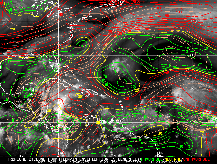
WalterWhite wrote:tolakram wrote:WalterWhite wrote:For some reason, wind shear seems to be unfavorable throughout most of the Atlantic basin.
https://i.postimg.cc/W1KW0f7p/wg8shr.gif
El Nino finally starting to win the battle. Maybe. Models show unfavorable wind shear in the future as well, but the model shear forecasts can be horribly inaccurate. If el nino does start winning I still expect a lot of storms to spin up when they find favorable spots. We shall see.
The fact that wind shear is very low throughout the Gulf of Mexico and certain portions of the Caribbean makes me think it is not because of the El Nino but rather something else.
I think it is related to the MJO transitioning from Phase IV to Phase V, which is less favorable for Atlantic activity. Unfavorable MJO phases lead to sinking air over the Atlantic, which increases vertical wind shear. Shear will probably more favorable circa October 10, when the MJO is expected come back in phase.
3 likes
-
galaxy401

- Category 5

- Posts: 2446
- Age: 30
- Joined: Sat Aug 25, 2012 9:04 pm
- Location: Casa Grande, Arizona
Re: 2023 Indicators (SST, SAL, MSLP, Wind shear, Steering, Instability) and Day 16+ Models
Considering it's late September, it's quite interesting that all the major basins are inactive at the moment especially in the Pacific. Atlantic had least has a Tropical Storm active.
0 likes
Got my eyes on moving right into Hurricane Alley: Florida.
Re: 2023 Indicators (SST, SAL, MSLP, Wind shear, Steering, Instability) and Day 16+ Models
WalterWhite wrote:WalterWhite wrote:tolakram wrote:
El Nino finally starting to win the battle. Maybe. Models show unfavorable wind shear in the future as well, but the model shear forecasts can be horribly inaccurate. If el nino does start winning I still expect a lot of storms to spin up when they find favorable spots. We shall see.
The fact that wind shear is very low throughout the Gulf of Mexico and certain portions of the Caribbean makes me think it is not because of the El Nino but rather something else.
I think it is related to the MJO transitioning from Phase IV to Phase V, which is less favorable for Atlantic activity. Unfavorable MJO phases lead to sinking air over the Atlantic, which increases vertical wind shear. Shear will probably more favorable circa October 10, when the MJO is expected come back in phase.
Could explain why the Canadian ensembles go bonkers after the 10th.
1 likes
-
Sciencerocks
- Category 5
- Posts: 10189
- Age: 40
- Joined: Thu Jul 06, 2017 1:51 am
-
REDHurricane

- Category 1
- Posts: 438
- Age: 28
- Joined: Sun Jul 03, 2022 2:36 pm
- Location: Northeast Pacific Ocean
Re: 2023 Indicators (SST, SAL, MSLP, Wind shear, Steering, Instability) and Day 16+ Models
galaxy401 wrote:Considering it's late September, it's quite interesting that all the major basins are inactive at the moment especially in the Pacific. Atlantic had least has a Tropical Storm active.
To me this could certainly portend an active October/November; it's not like all that warm water is going anywhere anytime soon...
0 likes
-
WalterWhite
- Category 1
- Posts: 342
- Joined: Fri Mar 17, 2023 5:53 pm
Re: 2023 Indicators (SST, SAL, MSLP, Wind shear, Steering, Instability) and Day 16+ Models
The GEFs ensembles are hinting at more MDR activity circa October 12.
1 likes

Re: 2023 Indicators (SST, SAL, MSLP, Wind shear, Steering, Instability) and Day 16+ Models
The 2023 season already has 18 named storms. With just one more, it will be tied with 1887, 1995, 2010, 2011 and 2012 as the fifth most active season on record in terms of named storm count. With three more, it will be tied with 2021 as the third most active season.
None of the storms this year were questionable in naming, either. Even short-lived storms like Arlene, Emily and Ophelia were clearly TSes.
None of the storms this year were questionable in naming, either. Even short-lived storms like Arlene, Emily and Ophelia were clearly TSes.
1 likes
TC naming lists: retirements and intensity
Most aggressive Advisory #1's in North Atlantic (cr. kevin for starting the list)
Most aggressive Advisory #1's in North Atlantic (cr. kevin for starting the list)
-
WalterWhite
- Category 1
- Posts: 342
- Joined: Fri Mar 17, 2023 5:53 pm
Re: 2023 Indicators (SST, SAL, MSLP, Wind shear, Steering, Instability) and Day 16+ Models
Teban54 wrote:The 2023 season already has 18 named storms. With just one more, it will be tied with 1887, 1995, 2010, 2011 and 2012 as the fifth most active season on record in terms of named storm count. With three more, it will be tied with 2021 as the third most active season.
None of the storms this year were questionable in naming, either. Even short-lived storms like Arlene, Emily and Ophelia were clearly TSes.
So far, however, these storms have been lacking in quality. Only 1/3 of these have become hurricanes. Typically, 1/2 of the storms in a season become hurricanes.
That will probably change soon, though. Either Rina or Philippe will probably become a hurricane. Hurricanes could also form in October and November.
1 likes
-
WalterWhite
- Category 1
- Posts: 342
- Joined: Fri Mar 17, 2023 5:53 pm
Re: 2023 Indicators (SST, SAL, MSLP, Wind shear, Steering, Instability) and Day 16+ Models
The 2013-2022 mean ACE for Atlantic hurricane seasons during OND is 34.9 hkt^2. Currently, the 2023 Atlantic Hurricane has an accumulated cyclone energy of 123.9 hkt^2. The official NHC forecast is calling for an additional 0.25 hkt^2 of ACE from Phillipe and an additional 0.16 hkt^2 of ACE from Rina; thus, according to official NHC forecasts, the 2023 Atlantic Hurricane Season should end with 124.3 hkt^2 of accumulated cyclone energy. Adding an additional 34.9 hkt^2 of ACE for OND gives a seasonal total of 159.2 hkt^2 of ACE, which is just below the hyperactive threshold. There is still a realistic chance this season ends as a hyperactive one. (In fact, whether or not this season becomes hyperactive is a tossup in my opinion.)
1 likes
-
tolakram
- Admin

- Posts: 20186
- Age: 62
- Joined: Sun Aug 27, 2006 8:23 pm
- Location: Florence, KY (name is Mark)
Re: 2023 Indicators (SST, SAL, MSLP, Wind shear, Steering, Instability) and Day 16+ Models
WalterWhite wrote:Teban54 wrote:The 2023 season already has 18 named storms. With just one more, it will be tied with 1887, 1995, 2010, 2011 and 2012 as the fifth most active season on record in terms of named storm count. With three more, it will be tied with 2021 as the third most active season.
None of the storms this year were questionable in naming, either. Even short-lived storms like Arlene, Emily and Ophelia were clearly TSes.
So far, however, these storms have been lacking in quality. Only 1/3 of these have become hurricanes. Typically, 1/2 of the storms in a season become hurricanes.
That will probably change soon, though. Either Rina or Philippe will probably become a hurricane. Hurricanes could also form in October and November.
If I was asked last year what would an el nino year look like if every condition was favorable except for upper air I think my guess would have been numerous storms, a few reaching major status if they found a small area of favorable conditions. This seems to be exactly what is happening, regardless of actual "nino like" conditions.
4 likes
M a r k
- - - - -
Join us in chat: Storm2K Chatroom Invite. Android and IOS apps also available.
The posts in this forum are NOT official forecasts and should not be used as such. Posts are NOT endorsed by any professional institution or STORM2K.org. For official information and forecasts, please refer to NHC and NWS products.
-
gatorcane

- S2K Supporter

- Posts: 23708
- Age: 48
- Joined: Sun Mar 13, 2005 3:54 pm
- Location: Boca Raton, FL
Re: 2023 Indicators (SST, SAL, MSLP, Wind shear, Steering, Instability) and Day 16+ Models
Models showing an active EPAC over the next 10-14 days = quiet Caribbean and Gulf. It is quite possible significant threats to the Gulf and Florida are done despite October being a high strike probability month for peninsula Florida. El Niño should exert its influence even more as we head into October. Still can’t rule out something sheared that tries to get going down there or something which tracks NE through Cuba or the Caribbean.
1 likes
-
Hurricane2022

- Category 5
- Posts: 2090
- Joined: Tue Aug 23, 2022 11:38 pm
- Location: Araçatuba, Brazil
Re: 2023 Indicators (SST, SAL, MSLP, Wind shear, Steering, Instability) and Day 16+ Models
gatorcane wrote:Models showing an active EPAC over the next 10-14 days = quiet Caribbean and Gulf. It is quite possible significant threats to the Gulf and Florida are done despite October being a high strike probability month for peninsula Florida. El Niño should exert its influence even more as we head into October.
Maybe not.
https://youtu.be/R6MlFEmLwF8?si=8843uQsomRgcaeTX
0 likes
Sorry for the bad English sometimes...!
For reliable and detailed information for any meteorological phenomenon, please consult the National Hurricane Center, Joint Typhoon Warning Center , or your local Meteo Center.
--------
ECCE OMNIA NOVA FACIAM (Ap 21,5).
For reliable and detailed information for any meteorological phenomenon, please consult the National Hurricane Center, Joint Typhoon Warning Center , or your local Meteo Center.
--------
ECCE OMNIA NOVA FACIAM (Ap 21,5).
-
REDHurricane
- Category 1
- Posts: 438
- Age: 28
- Joined: Sun Jul 03, 2022 2:36 pm
- Location: Northeast Pacific Ocean
Re: 2023 Indicators (SST, SAL, MSLP, Wind shear, Steering, Instability) and Day 16+ Models
gatorcane wrote:Models showing an active EPAC over the next 10-14 days = quiet Caribbean and Gulf. It is quite possible significant threats to the Gulf and Florida are done despite October being a high strike probability month for peninsula Florida. El Niño should exert its influence even more as we head into October. Still can’t rule out something sheared that tries to get going down there or something which tracks NE through Cuba or the Caribbean.
I wouldn't be so sure just yet -- remember how all the models in the middle of August were showing basically zero activity through 10-14 days out? As we've seen, the models oftentimes are slow to pick up on these seasonal pattern changes, so any model forecast past ~7 days out should be taken with a boulder of salt at this point.
1 likes
-
WeatherBoy2000
- Category 1
- Posts: 463
- Joined: Mon Apr 10, 2023 9:29 am
Re: 2023 Indicators (SST, SAL, MSLP, Wind shear, Steering, Instability) and Day 16+ Models
Hurricane2022 wrote:gatorcane wrote:Models showing an active EPAC over the next 10-14 days = quiet Caribbean and Gulf. It is quite possible significant threats to the Gulf and Florida are done despite October being a high strike probability month for peninsula Florida. El Niño should exert its influence even more as we head into October.
Maybe not.
https://youtu.be/R6MlFEmLwF8?si=8843uQsomRgcaeTX
I'm really in the "I'll believe when I see it" attitude when it comes the El nino shutting down the Atlantic. Ever since Aug people have been saying on Twitter and even here that the Atlantic will be shutting down soon and it just hasn't happened. Outside a two week slowdown mid September where only Nigel formed, the Atlantic has been very active.
1 likes
Who is online
Users browsing this forum: No registered users and 192 guests