EPAC: LIDIA - Remnants - Discussion
Moderator: S2k Moderators
-
Hurricane2022

- Category 5

- Posts: 2093
- Joined: Tue Aug 23, 2022 11:38 pm
- Location: Araçatuba, Brazil
Re: EPAC: LYDIA - Tropical Storm - Discussion
Lydia?
0 likes
Sorry for the bad English sometimes...!
For reliable and detailed information for any meteorological phenomenon, please consult the National Hurricane Center, Joint Typhoon Warning Center , or your local Meteo Center.
--------
ECCE OMNIA NOVA FACIAM (Ap 21,5).
For reliable and detailed information for any meteorological phenomenon, please consult the National Hurricane Center, Joint Typhoon Warning Center , or your local Meteo Center.
--------
ECCE OMNIA NOVA FACIAM (Ap 21,5).
-
cycloneye

- Admin

- Posts: 149730
- Age: 69
- Joined: Thu Oct 10, 2002 10:54 am
- Location: San Juan, Puerto Rico
Re: EPAC: LYDIA - Tropical Storm - Discussion
Hurricane2022 wrote:Lydia?
Fixed it.
0 likes
Visit the Caribbean-Central America Weather Thread where you can find at first post web cams,radars
and observations from Caribbean basin members Click Here
and observations from Caribbean basin members Click Here
-
Sciencerocks
- Category 5
- Posts: 10193
- Age: 40
- Joined: Thu Jul 06, 2017 1:51 am

-
cycloneye
- Admin
- Posts: 149730
- Age: 69
- Joined: Thu Oct 10, 2002 10:54 am
- Location: San Juan, Puerto Rico
Re: EPAC: LIDIA - Tropical Storm - Discussion
Tropical Storm Lidia Discussion Number 2
NWS National Hurricane Center Miami FL EP152023
900 AM MDT Tue Oct 03 2023
Lidia continues to have bursts of deep convection this morning,
with cold cloud tops to -80 degrees Celsius. An earlier AMSR2
microwave pass depicted a curved banding feature developing to the
west and north of the low-level center, as Lidia's convection
continues to organize. A blend of subjective and objective
satellite intensity estimates are around 35 kt, which is in good
agreement with the earlier scatterometer passes from this morning.
Therefore, the initial intensity for this advisory remains 35 kt.
The system is moving west-northwest at 300/8 kt, around the southern
edge of a mid-level ridge located over Mexico. A mid- to
upper-level trough to the northwest will begin to weaken the ridge
allowing Lidia to move more northwest to north-northwest the next
few days. The guidance envelope is in fairly good agreement with
this general motion the next 48 hours or so. Beyond day 2, there is
a little more uncertainty in the forecast as models differ on the
timing of the mid-level ridge building back in as the trough lifts
out of the area. The GFS and ECMWF turn the system more westward as
the ridge strengthens, compared to some of the hurricane regional
models, like HAFS-A and HAFS-B, which continue a more northward
motion. The NHC forecast is closer to the ECMWF/GFS solutions
through the end of the forecast period, with a slow turn westward.
Lidia is currently dealing with some moderate easterly vertical wind
shear. The ECMWF/GFS SHIPS guidance depicts that moderate shear will
remain over the system throughout the forecast period. The system
will remain over fairly warm sea-surface temperatures near 30 C, and
a favorable upper-level wind pattern with divergence aloft. RI
parameters are slightly lower in the short-term compared to the
previous cycle. However, the ECMWF-SHIPS has a 55 percent chance of
a 65-kt increase in 72 hours. While this will not be explicitly
forecast we will continue to monitor these parameters and trends in
subsequent forecasts. The NHC intensity forecast is fairly similar
to the previous showing gradual intensification throughout the
period, and lies near the IVCN simple consensus aid.
FORECAST POSITIONS AND MAX WINDS
INIT 03/1500Z 12.3N 107.6W 35 KT 40 MPH
12H 04/0000Z 13.1N 108.5W 40 KT 45 MPH
24H 04/1200Z 14.0N 109.3W 45 KT 50 MPH
36H 05/0000Z 14.8N 109.7W 50 KT 60 MPH
48H 05/1200Z 15.4N 110.0W 55 KT 65 MPH
60H 06/0000Z 15.9N 110.4W 60 KT 70 MPH
72H 06/1200Z 16.0N 111.0W 65 KT 75 MPH
96H 07/1200Z 15.9N 112.3W 65 KT 75 MPH
120H 08/1200Z 15.9N 114.0W 65 KT 75 MPH
0 likes
Visit the Caribbean-Central America Weather Thread where you can find at first post web cams,radars
and observations from Caribbean basin members Click Here
and observations from Caribbean basin members Click Here
-
Yellow Evan

- Professional-Met

- Posts: 16257
- Age: 27
- Joined: Fri Jul 15, 2011 12:48 pm
- Location: Henderson, Nevada/Honolulu, HI
- Contact:
Re: EPAC: LIDIA - Tropical Storm - Discussion
Given the small size the shear will likely be too high of magnitude for significant strengthening even if the shear is deep layer.
0 likes
-
cycloneye
- Admin
- Posts: 149730
- Age: 69
- Joined: Thu Oct 10, 2002 10:54 am
- Location: San Juan, Puerto Rico
Re: EPAC: LIDIA - Tropical Storm - Discussion
Euro joins GFS on making landfall in Mexico.

0 likes
Visit the Caribbean-Central America Weather Thread where you can find at first post web cams,radars
and observations from Caribbean basin members Click Here
and observations from Caribbean basin members Click Here
-
Sciencerocks
- Category 5
- Posts: 10193
- Age: 40
- Joined: Thu Jul 06, 2017 1:51 am

-
cycloneye
- Admin
- Posts: 149730
- Age: 69
- Joined: Thu Oct 10, 2002 10:54 am
- Location: San Juan, Puerto Rico
Re: EPAC: LIDIA - Tropical Storm - Discussion
Tropical Storm Lidia Discussion Number 3
NWS National Hurricane Center Miami FL EP152023
300 PM MDT Tue Oct 03 2023
Lidia continues to exhibit a curved band on geostationary and
microwave satellite imagery this afternoon. Deep convection is
predominately developing to the west of the low-level center due to
the influence of moderate easterly vertical wind shear. The initial
intensity is held at 35 kt for this advisory in agreement with the
subjective Dvorak intensity estimates from TAFB and SAB, and the
objective intensity estimates, ADT and AiDT from UW-CIMSS.
The system is moving northwest at 320/7 kt around the southwestern
edge of a mid-level ridge located over Mexico. A mid- to upper-level
trough to the northwest will begin to weaken the ridge allowing
Lidia to move northwest to north-northwest during the next 48 hours.
Most models are now in agreement with a more westward motion in
Lidia between 48 and 72 hours. There are large differences in the
speed of the system, with the UKMET accelerating towards the west
faster than the other global models. The forward speed of the system
was adjusted slightly faster for this advisory in the short term,
and the track forecast is in line with the simple consensus aids.
Lidia is still battling some moderate easterly vertical wind shear.
The ECMWF/GFS SHIPS guidance depicts that moderate shear will remain
over the system throughout much of the forecast period despite
otherwise favorable environmental conditions. The guidance for RI
continues to lessen the probability with this cycle. The GFS, HWRF,
and SHIPS models still strengthen Lidia into a hurricane beyond 2
days, however much of the other guidance, including the HAFS models,
does not intensify Lidia as much. The NHC intensity forecast was
lowered slightly from the previous advisory and continues to show
gradual strengthening to a hurricane by day 5.
FORECAST POSITIONS AND MAX WINDS
INIT 03/2100Z 12.8N 107.6W 35 KT 40 MPH
12H 04/0600Z 13.7N 108.2W 40 KT 45 MPH
24H 04/1800Z 14.5N 108.9W 40 KT 45 MPH
36H 05/0600Z 15.2N 109.3W 45 KT 50 MPH
48H 05/1800Z 15.7N 109.8W 50 KT 60 MPH
60H 06/0600Z 15.9N 110.3W 55 KT 65 MPH
72H 06/1800Z 15.9N 111.1W 55 KT 65 MPH
96H 07/1800Z 15.7N 112.5W 60 KT 70 MPH
120H 08/1800Z 15.8N 114.1W 65 KT 75 MPH
0 likes
Visit the Caribbean-Central America Weather Thread where you can find at first post web cams,radars
and observations from Caribbean basin members Click Here
and observations from Caribbean basin members Click Here
-
Sciencerocks
- Category 5
- Posts: 10193
- Age: 40
- Joined: Thu Jul 06, 2017 1:51 am

-
cycloneye
- Admin
- Posts: 149730
- Age: 69
- Joined: Thu Oct 10, 2002 10:54 am
- Location: San Juan, Puerto Rico
Re: EPAC: LIDIA - Tropical Storm - Discussion
Tropical Storm Lidia Discussion Number 4
NWS National Hurricane Center Miami FL EP152023
900 PM MDT Tue Oct 03 2023
Lidia has changed little since the last advisory. Last-light
geostationary satellite imagery showed a small, deep burst of
convection forming over the low-level center, with the majority of
the cold cloud tops in the northwestern portion of the circulation.
Subjective and objective satellite intensity estimates have held
steady this cycle, and the initial intensity remains at 35 kt.
The storm is moving northwestward at an estimated 6 kt. A mid-level
ridge centered over the northwestern Gulf of Mexico should continue
to steer the storm generally northwestward for the next day or so.
By Thursday, Lidia should turn west-northwestward to westward along
the south side of the ridge as it builds westward. While the model
guidance generally agrees on the turn westward, there is still quite
a bit of spread in the along-track speed. The corrected consensus
aid, HCCA, favors a slower solution while the simple consensus aids,
TVCN and TVCE, show faster forward speeds and a progression farther
to the west. The latest NHC track guidance is similar to the
previous advisory and favors the simple consensus aids.
Lidia is in an environment of moderate-to-strong easterly vertical
wind shear. Global models predict that these atmospheric conditions
should persist for the majority of the forecast period. Still,
other conditions such as the warm sea surface temperatures and a
relatively moist surrounding airmass, should allow for some gradual
strengthening. Only minor adjustments have been made to the
official intensity forecast, which is close to the consensus aid,
IVCN.
FORECAST POSITIONS AND MAX WINDS
INIT 04/0300Z 13.4N 107.9W 35 KT 40 MPH
12H 04/1200Z 14.2N 108.4W 40 KT 45 MPH
24H 05/0000Z 15.0N 108.9W 40 KT 45 MPH
36H 05/1200Z 15.5N 109.4W 40 KT 45 MPH
48H 06/0000Z 15.7N 109.9W 45 KT 50 MPH
60H 06/1200Z 15.7N 110.5W 50 KT 60 MPH
72H 07/0000Z 15.7N 111.4W 55 KT 65 MPH
96H 08/0000Z 15.5N 112.9W 60 KT 70 MPH
120H 09/0000Z 15.7N 114.1W 65 KT 75 MPH
0 likes
Visit the Caribbean-Central America Weather Thread where you can find at first post web cams,radars
and observations from Caribbean basin members Click Here
and observations from Caribbean basin members Click Here
-
Sciencerocks
- Category 5
- Posts: 10193
- Age: 40
- Joined: Thu Jul 06, 2017 1:51 am

-
Kingarabian

- S2K Supporter

- Posts: 16379
- Joined: Sat Aug 08, 2009 3:06 am
- Location: Honolulu, Hawaii
Re: EPAC: LIDIA - Tropical Storm - Discussion
Clear signs of moderate-strong easterly shear. Euro keeps it weak over the next 7 days before finally intensifying when it moves east back close to Mexico.
0 likes
RIP Kobe Bryant

Re: EPAC: LIDIA - Tropical Storm - Discussion
Lmao, HWRF went from Cat 4 to TS in a single run 
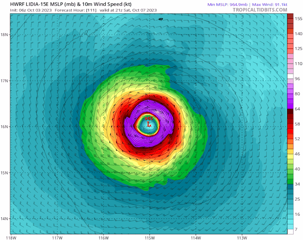
Within the forecast period, no models really make Lidia a hurricane anymore. Well see whether Lidia has better luck when it swings back east.
Within the forecast period, no models really make Lidia a hurricane anymore. Well see whether Lidia has better luck when it swings back east.
0 likes
TC naming lists: retirements and intensity
Most aggressive Advisory #1's in North Atlantic (cr. kevin for starting the list)
Most aggressive Advisory #1's in North Atlantic (cr. kevin for starting the list)
-
cycloneye
- Admin
- Posts: 149730
- Age: 69
- Joined: Thu Oct 10, 2002 10:54 am
- Location: San Juan, Puerto Rico
Re: EPAC: LIDIA - Tropical Storm - Discussion
Tropical Storm Lidia Discussion Number 5
NWS National Hurricane Center Miami FL EP152023
300 AM MDT Wed Oct 04 2023
Earlier microwave imagery and recent geostationary satellite data
indicate that the low-level center of Lidia is located just beneath
the eastern edge of a large convective mass with cloud top
temperatures below -80 degrees C. The most recent subjective Dvorak
intensity estimates from TAFB and SAB were T3.0 (45 kt) and T2.5 (35
kt), respectively. Since the center appears to be slightly more
embedded within the deep convection, the initial intensity is raised
to 40 kt, using a blend of the subjective Dvorak estimates. A very
recently arriving GMI microwave overpass shows that there has been
some increase in organization, but the mid-level center is
displaced about 30-40 n mi west of the low-level center.
The initial motion estimate is north-northwestward or 330 degrees at
7 kt. The track forecast reasoning is unchanged from before. A
mid-level ridge over the northwestern Gulf of Mexico is expected to
steer the cyclone northwestward to north-northwestward during the
next 24 to 36 hours. After that time, a narrow ridge is forecast to
build to the north of Lidia which should result in a slower westward
motion through much of the remainder of the forecast period. There
is still a large amount of along-track spread in the guidance after
the westward turn, with the UKMET and ECMWF on the faster side of
the guidance envelope. The GFS and HAFS-A/B models are much
slower. It should also be noted that there is unusually large
spread between the HFIP corrected consensus model and the various
multi-model consensus aids. This results in lower-than-normal
confidence in Lidia's long range track forecast. The NHC track
forecast is close to a blend of the GFS, ECMWF, and regional
hurricane models.
The SHIPS guidance indicates that moderate-to-strong easterly
vertical wind shear will persist over Lidia during the next several
days. However, other environmental conditions consisting of warm
sea surface temperatures and a moist environment favor some
strengthening. As a result, the NHC intensity forecast calls from
slow intensification during the next several days, but it is a
little lower than the previous forecast at the long range. The
updated NHC wind speed forecast is a little above the latest HCCA
and IVCN consensus models.
FORECAST POSITIONS AND MAX WINDS
INIT 04/0900Z 14.0N 108.3W 40 KT 45 MPH
12H 04/1800Z 14.8N 108.7W 45 KT 50 MPH
24H 05/0600Z 15.3N 109.1W 45 KT 50 MPH
36H 05/1800Z 15.7N 109.5W 45 KT 50 MPH
48H 06/0600Z 15.8N 110.1W 50 KT 60 MPH
60H 06/1800Z 15.7N 110.9W 50 KT 60 MPH
72H 07/0600Z 15.6N 111.8W 55 KT 65 MPH
96H 08/0600Z 15.5N 113.4W 60 KT 70 MPH
120H 09/0600Z 15.9N 114.3W 60 KT 70 MPH
0 likes
Visit the Caribbean-Central America Weather Thread where you can find at first post web cams,radars
and observations from Caribbean basin members Click Here
and observations from Caribbean basin members Click Here
-
cycloneye
- Admin
- Posts: 149730
- Age: 69
- Joined: Thu Oct 10, 2002 10:54 am
- Location: San Juan, Puerto Rico
Re: EPAC: LIDIA - Tropical Storm - Discussion
EP, 15, 2023100412, , BEST, 0, 145N, 1086W, 45, 1001, TS
0 likes
Visit the Caribbean-Central America Weather Thread where you can find at first post web cams,radars
and observations from Caribbean basin members Click Here
and observations from Caribbean basin members Click Here
-
Sciencerocks
- Category 5
- Posts: 10193
- Age: 40
- Joined: Thu Jul 06, 2017 1:51 am

-
cycloneye
- Admin
- Posts: 149730
- Age: 69
- Joined: Thu Oct 10, 2002 10:54 am
- Location: San Juan, Puerto Rico
Re: EPAC: LIDIA - Tropical Storm - Discussion
Tropical Storm Lidia Discussion Number 6
NWS National Hurricane Center Miami FL EP152023
900 AM MDT Wed Oct 04 2023
Lidia continues to produce a large convective rain shield, with
a deep convective burst and cloud top temperatures around -80
degrees Celsius. An earlier microwave pass depicts that the system
continues to gradually organize with a mid-level core developing,
but the low-level center is still displaced to the east of the
mid-level core, due to easterly vertical wind shear. Subjective
Dvorak intensity estimates this cycle from TAFB and SAB were T3.0/45
kt. Given the improved satellite depiction and intensity estimates
the initial intensity is raised to 45 kt for this advisory.
The initial motion is north-northwestward or 335 degrees at 7 kt. A
mid-level ridge over Mexico will continue to steer the system
north-northwestward during the next day or so. Afterwards, a ridge
will build to the north of Lidia which will result in a slower
forward motion and a turn towards the west through the remainder of
the forecast period. There continues to be a large spread in the
along-track guidance as the system turns westward. Most of the
global models are faster, while the hurricane regional models and
HCCA corrected consensus are slower. Therefore, there is increased
uncertainty in the long range track forecast. The NHC track is
slightly faster than the previous, and lies between the faster
global models and the slower regional models.
Models are in fairly good agreement that the moderate-to-strong
easterly vertical wind shear will continue to persist over Lidia the
next several days. However, warm sea surface temperatures, a moist
environment and upper-level diffluence will allow slow strengthening
of the system. The NHC intensity forecast is similar to the previous
forecast, and the intensity forecast lies near the IVCN consensus
aid.
FORECAST POSITIONS AND MAX WINDS
INIT 04/1500Z 14.8N 108.6W 45 KT 50 MPH
12H 05/0000Z 15.5N 109.2W 45 KT 50 MPH
24H 05/1200Z 16.0N 109.8W 50 KT 60 MPH
36H 06/0000Z 16.1N 110.4W 50 KT 60 MPH
48H 06/1200Z 16.1N 111.0W 50 KT 60 MPH
60H 07/0000Z 15.9N 111.8W 55 KT 65 MPH
72H 07/1200Z 15.7N 112.7W 60 KT 70 MPH
96H 08/1200Z 16.0N 114.3W 60 KT 70 MPH
120H 09/1200Z 16.3N 115.0W 60 KT 70 MPH
0 likes
Visit the Caribbean-Central America Weather Thread where you can find at first post web cams,radars
and observations from Caribbean basin members Click Here
and observations from Caribbean basin members Click Here
-
Sciencerocks
- Category 5
- Posts: 10193
- Age: 40
- Joined: Thu Jul 06, 2017 1:51 am

-
cycloneye
- Admin
- Posts: 149730
- Age: 69
- Joined: Thu Oct 10, 2002 10:54 am
- Location: San Juan, Puerto Rico
Re: EPAC: LIDIA - Tropical Storm - Discussion
Tropical Storm Lidia Discussion Number 7
NWS National Hurricane Center Miami FL EP152023
300 PM MDT Wed Oct 04 2023
Lidia is experiencing a robust burst of convection very near the
center of low-level circulation in the past couple of hours, but
displays little overall change in appearance and organization since
this morning. Shortly after the previous advisory the low-level
center became exposed to the east of the deep convection on visible
GOES-18 satellite. Within the past few hours, the low-level center
is now under a deep burst of convection, allowing subjective Dvorak
intensity estimates this cycle from TAFB and SAB to remain at
T3.0/45 kt. Thus, initial intensity remains at 45 kt for this
advisory.
The initial motion is north-northwestward or 335 degrees at 6 kt. A
mid-level ridge over Mexico will continue to steer the system
north-northwestward during the next day or so. Afterwards, a ridge
will build to the north of Lidia which will result in a slower
forward motion and a turn towards the west through the remainder of
the forecast period. There continues to be a large spread in the
along-track guidance as the system turns westward. Most of the
global models are faster, while the hurricane regional models and
HCCA corrected consensus aid are slower. Therefore, there is
increased uncertainty in the long range track forecast. The NHC
track exhibits little change from the previous advisory, and lies
between the faster global models and the slower regional models.
Models are in fairly good agreement that the moderate-to-strong
easterly vertical wind shear will persist over Lidia the next
several days. However, warm sea surface temperatures, a moist
environment and upper-level diffluence will allow slow strengthening
of the system. The NHC intensity forecast is similar to the previous
forecast, and the intensity forecast lies near the IVCN consensus
aid.
FORECAST POSITIONS AND MAX WINDS
INIT 04/2100Z 15.2N 108.9W 45 KT 50 MPH
12H 05/0600Z 15.7N 109.3W 45 KT 50 MPH
24H 05/1800Z 16.1N 109.9W 50 KT 60 MPH
36H 06/0600Z 16.1N 110.5W 50 KT 60 MPH
48H 06/1800Z 16.0N 111.3W 50 KT 60 MPH
60H 07/0600Z 15.8N 112.2W 55 KT 65 MPH
72H 07/1800Z 15.8N 113.0W 60 KT 70 MPH
96H 08/1800Z 16.1N 114.4W 60 KT 70 MPH
120H 09/1800Z 16.6N 114.9W 60 KT 70 MPH
0 likes
Visit the Caribbean-Central America Weather Thread where you can find at first post web cams,radars
and observations from Caribbean basin members Click Here
and observations from Caribbean basin members Click Here
-
cycloneye
- Admin
- Posts: 149730
- Age: 69
- Joined: Thu Oct 10, 2002 10:54 am
- Location: San Juan, Puerto Rico
Re: EPAC: LIDIA - Tropical Storm - Discussion
Tropical Storm Lidia Discussion Number 8
NWS National Hurricane Center Miami FL EP152023
900 PM MDT Wed Oct 04 2023
Lidia has maintained its small, sheared structure for the past
several hours. Convection has been waning, but infrared
geostationary imagery shows a growing burst of convection
developing west of the estimated low-level center. Microwave
imagery also revealed a large curved band around the western and
northern portion of the circulation. Subjective and objective
satellite intensity guidance nearly all agree on a 45-kt estimate,
and therefore, the initial intensity is held constant for this
advisory.
The storm has a somewhat uncertain motion since the center position
is obscured by the cirrus canopy, but the direction is estimated to
be northwestward, or 325/6 kt. A mid-level ridge over Mexico is
steering Lidia, and the storm is expected to maintain its current
motion for the next 12 hours or so. Then the ridge is forecast to
build and turn the cyclone westward in the next day or so, with a
slight decrease in forward motion. By day 5, global models predict
the ridge will erode and turn Lidia northwestward. There is still
above average spread in the model guidance, largely due to the
along-track differences in the westward progression of the storm.
The latest official track forecast has shifted slightly north of the
previous advisory and favors the simple consensus aid, TVCE.
There are competing factors contributing to the intensity forecast.
While the storm is forecast to be over warm ocean waters and in an
area of decent mid-level moisture, a limiting factor is still the
moderate-to-strong deep-layer vertical wind shear. Most models
show gradual strengthening, and minor adjustments have been made to
the latest NHC intensity forecast, which is closest to the IVCN
consensus aid.
FORECAST POSITIONS AND MAX WINDS
INIT 05/0300Z 15.6N 109.4W 45 KT 50 MPH
12H 05/1200Z 16.0N 109.8W 45 KT 50 MPH
24H 06/0000Z 16.2N 110.4W 50 KT 60 MPH
36H 06/1200Z 16.3N 111.1W 50 KT 60 MPH
48H 07/0000Z 16.1N 112.0W 55 KT 65 MPH
60H 07/1200Z 16.0N 112.8W 60 KT 70 MPH
72H 08/0000Z 16.1N 113.6W 60 KT 70 MPH
96H 09/0000Z 16.5N 114.7W 60 KT 70 MPH
120H 10/0000Z 17.0N 115.0W 60 KT 70 MPH
0 likes
Visit the Caribbean-Central America Weather Thread where you can find at first post web cams,radars
and observations from Caribbean basin members Click Here
and observations from Caribbean basin members Click Here
Who is online
Users browsing this forum: No registered users and 73 guests