
EPAC: LIDIA - Remnants - Discussion
Moderator: S2k Moderators
-
Sciencerocks
- Category 5

- Posts: 10193
- Age: 40
- Joined: Thu Jul 06, 2017 1:51 am
-
Yellow Evan

- Professional-Met

- Posts: 16257
- Age: 27
- Joined: Fri Jul 15, 2011 12:48 pm
- Location: Henderson, Nevada/Honolulu, HI
- Contact:
Re: EPAC: LIDIA - Tropical Storm - Discussion
0z GFS came in with 40 knots of shear in the 3-4 day range now.
0 likes
-
cycloneye

- Admin

- Posts: 149702
- Age: 69
- Joined: Thu Oct 10, 2002 10:54 am
- Location: San Juan, Puerto Rico
Re: EPAC: LIDIA - Tropical Storm - Discussion
Tropical Storm Lidia Discussion Number 9
NWS National Hurricane Center Miami FL EP152023
300 AM MDT Thu Oct 05 2023
This morning's satellite presentation consists of a sheared cloud
pattern with the surface center located near the eastern edge of the
convective canopy. Although the upper wind pattern is quite
diffluent over Lidia, easterly shear continues to restrict the
intensification rate. The Dvorak satellite intensity estimates
yield 45 kt from TAFB and SAB, and the initial intensity remains
unchanged for this advisory. However, based on the 0411 UTC METOP-B
scatterometer overpass, this could be generous.
The statistical GFS/ECMWF SHIPS guidance indicates that the moderate
deep-layer shear should persist over Lidia through the majority of
the forecast period. Warm oceanic surface temperatures and a very
moist surrounding low- to mid-tropospheric thermodynamic environment
support modest strengthening over the next few days, and the NHC
forecast follows suit. The official intensity forecast shows a
peak intensity in 3 days and now indicates some weakening
afterward due to an increase in shear magnitude (a combination of
the cyclone's eastward trajectory and persistent easterly shear) and
is based on a blend of the SHIPS and IVCN intensity guidance.
Lidia's is still moving northwestward, or 315/4 kt, and is being
steered by a subtropical high located to the northeast over the
west coast of central Mexico. Around the 36-hour period, the ridge
is forecast to build temporarily and turn Lidia westward with some
further reduction in forward speed. In 72 hours, the cyclone should
gradually turn toward the northwest to north followed by a turn
toward the northeast near the end of the period in response to an
approaching sharp shortwave trough from the northwest, causing a
break in the aforementioned subtropical ridge. The NHC track
forecast is based on a blend of the TVCE and HFIP HCCA consensus
models and is shifted a little to the right of the previous
advisory beyond day 3.
Based on the METOP-B scatterometer swath, Lidia's wind radii were
increased slightly northeast through southwest.
FORECAST POSITIONS AND MAX WINDS
INIT 05/0900Z 15.7N 109.5W 45 KT 50 MPH
12H 05/1800Z 15.9N 109.8W 45 KT 50 MPH
24H 06/0600Z 16.1N 110.4W 50 KT 60 MPH
36H 06/1800Z 16.0N 111.1W 50 KT 60 MPH
48H 07/0600Z 15.9N 111.9W 55 KT 65 MPH
60H 07/1800Z 16.0N 112.7W 60 KT 70 MPH
72H 08/0600Z 16.2N 113.3W 60 KT 70 MPH
96H 09/0600Z 17.1N 114.2W 55 KT 65 MPH
120H 10/0600Z 17.8N 113.5W 50 KT 60 MPH
0 likes
Visit the Caribbean-Central America Weather Thread where you can find at first post web cams,radars
and observations from Caribbean basin members Click Here
and observations from Caribbean basin members Click Here
-
Sciencerocks
- Category 5
- Posts: 10193
- Age: 40
- Joined: Thu Jul 06, 2017 1:51 am

-
cycloneye
- Admin
- Posts: 149702
- Age: 69
- Joined: Thu Oct 10, 2002 10:54 am
- Location: San Juan, Puerto Rico
Re: EPAC: LIDIA - Tropical Storm - Discussion
EP, 15, 2023100512, , BEST, 0, 158N, 1097W, 50, 999, TS
0 likes
Visit the Caribbean-Central America Weather Thread where you can find at first post web cams,radars
and observations from Caribbean basin members Click Here
and observations from Caribbean basin members Click Here
-
cycloneye
- Admin
- Posts: 149702
- Age: 69
- Joined: Thu Oct 10, 2002 10:54 am
- Location: San Juan, Puerto Rico
Re: EPAC: LIDIA - Tropical Storm - Discussion
Tropical Storm Lidia Discussion Number 10
NWS National Hurricane Center Miami FL EP152023
900 AM MDT Thu Oct 05 2023
Lidia continues to have bursts of deep convection, with cold cloud
tops to -80 degrees Celsius, within the overall convective shield.
An AMSR2 microwave pass depicts that the mid-level core continues to
develop, with the low-level center displaced to the east of the
mid-level center. There is a wide range of satellite estimates this
morning. Subjective Dvorak intensity estimates from SAB and TAFB
were T3.5/55kt this cycle, while objective estimates from UW-CIMSS
AiDT and ADT range from 50 kt to 65 kt, respectively. However, an
earlier scatterometer pass around 0500 UTC had much lower winds
than anticipated near 35 kt. Given these higher satellite estimates
and satellite imagery, the initial intensity is raised to 50 kt,
which is on the lower end of the estimates and a little uncertain.
Another scatterometer pass is anticipated over the system this
afternoon.
Lidia continues to move slowly northwestward at 315/4 kt. The
system is being steered by a mid-level ridge centered over central
Mexico. By tonight, the ridge is forecast to strengthen to the
north which will cause the system to slow even more and turn
west-northwest then westward. In about 3 days, a mid-/upper-level
trough is forecast to approach from the northwest which
will weaken the aforementioned ridge. This will induce another turn
of Lidia to the northwest, then north to northeastward through
the end of the forecast period. There continues to be some spread
within the guidance envelope on the along-track forward speed and
when the turn back to the northeast occurs later in the forecast
period. The NHC track forecast is similar to the previous one and is
based on a blend of the TVCE and HCCA consensus aids.
Moderate deep-layer easterly shear should continue over Lidia
throughout the forecast period. Oceanic sea surface temperatures
remain warm along the forecast track, and the oceanic heat content
remains high. The system should remain a small compact system,
which may allow for fluctuations in intensity. GFS/ECMWF SHIPS
intensity probabilities of a 25-kt increase in 24 hr have increased
to 32 and 39 percent this cycle, respectively. While this is not
explicitly forecast, it is something where the trends will have to
continue to be monitored. The official intensity forecast has been
slightly raised in the short-term, with Lidia forecast to become a
hurricane in 48 h. Some weakening is forecast beyond 3 days due to
an increase in drier mid-level air and continued easterly shear. The
NHC intensity forecast lies near the simple corrected consensus,
IVCN intensity guidance.
FORECAST POSITIONS AND MAX WINDS
INIT 05/1500Z 15.9N 109.8W 50 KT 60 MPH
12H 06/0000Z 16.1N 110.1W 55 KT 65 MPH
24H 06/1200Z 16.1N 110.9W 55 KT 65 MPH
36H 07/0000Z 16.0N 111.7W 60 KT 70 MPH
48H 07/1200Z 16.0N 112.6W 65 KT 75 MPH
60H 08/0000Z 16.3N 113.5W 70 KT 80 MPH
72H 08/1200Z 16.9N 114.0W 65 KT 75 MPH
96H 09/1200Z 17.7N 114.0W 55 KT 65 MPH
120H 10/1200Z 18.1N 112.6W 55 KT 65 MPH
0 likes
Visit the Caribbean-Central America Weather Thread where you can find at first post web cams,radars
and observations from Caribbean basin members Click Here
and observations from Caribbean basin members Click Here
-
zeehag
- Tropical Storm

- Posts: 181
- Age: 77
- Joined: Sun Jul 17, 2011 9:49 pm
- Location: mazatlan,sinaloa, mexico, fixing patricia's mess.
- Contact:
Re: EPAC: LIDIA - Tropical Storm - Discussion
watching from mazatlan. i see the models with the landfall in area of mazatlan to san blas.. ok. not looking forward to this landfall. unless itis a remnant or weakening ts when it lands here.
0 likes
-
Sciencerocks
- Category 5
- Posts: 10193
- Age: 40
- Joined: Thu Jul 06, 2017 1:51 am

-
Sciencerocks
- Category 5
- Posts: 10193
- Age: 40
- Joined: Thu Jul 06, 2017 1:51 am

-
cycloneye
- Admin
- Posts: 149702
- Age: 69
- Joined: Thu Oct 10, 2002 10:54 am
- Location: San Juan, Puerto Rico
Re: EPAC: LIDIA - Tropical Storm - Discussion
Tropical Storm Lidia Discussion Number 11
NWS National Hurricane Center Miami FL EP152023
300 PM MDT Thu Oct 05 2023
Lidia's overall satellite depiction has not changed much from the
previous advisory. There continues to be intermittent burst of
deeper convection within the convective shield. A SSMIS microwave
pass depicts that the low-level center remains displaced to the east
of the mid-level core, suggesting that Lidia has not become any
better organized as it continues to battle easterly wind shear. The
subjective and objective intensity estimates range from 50 to 65 kt.
A partial scatterometer pass hit the NW side of the system but did
not depict winds as high as the current estimates, but missed the
central core. Given the overall satellite depiction remains similar
to this morning, the peak intensity remains 50 kt for this
advisory.
Lidia continues to move slowly northwestward at 315/3 kt. The system
is being steered by a strengthening mid-level ridge centered over
central Mexico. As the ridge strengthens, the system will continue
to move slowly and turn towards west-northwest then westward. In a
few days, a mid-/upper-level trough is forecast to approach from
the northwest which will weaken the aforementioned ridge. This will
induce another turn of Lidia to the northwest, then north to
northeastward through the end of the forecast period. There
continues to be some spread within the guidance envelope on the
along-track forward speed and when the turn back to the northeast
occurs later in the forecast period. The NHC track forecast is
similar to the previous in the short-term, but is a little faster
towards the end of the forecast period based on a blend of the TVCE
and HCCA consensus aids.
Moderate deep-layer easterly shear should continue over Lidia
throughout the forecast period. Sea surface temperatures remain warm
along the forecast track, with moist mid-level RH values the next
few days. The cyclone should remain a small compact system, which
may allow for fluctuations in intensity. The official intensity
forecast is similar to the previous, and Lidia could become a
hurricane this weekend. Some weakening is forecast in about 3 days
due to an increase in drier mid-level air and continued easterly
shear. The NHC intensity forecast is similar to the previous
advisory, which lies near the HCCA and IVCN consensus aids.
FORECAST POSITIONS AND MAX WINDS
INIT 05/2100Z 16.0N 109.9W 50 KT 60 MPH
12H 06/0600Z 16.1N 110.3W 55 KT 65 MPH
24H 06/1800Z 16.2N 111.1W 55 KT 65 MPH
36H 07/0600Z 16.2N 112.0W 60 KT 70 MPH
48H 07/1800Z 16.4N 113.0W 65 KT 75 MPH
60H 08/0600Z 17.0N 113.8W 70 KT 80 MPH
72H 08/1800Z 17.5N 113.9W 65 KT 75 MPH
96H 09/1800Z 18.3N 113.1W 55 KT 65 MPH
120H 10/1800Z 18.8N 111.6W 55 KT 65 MPH
0 likes
Visit the Caribbean-Central America Weather Thread where you can find at first post web cams,radars
and observations from Caribbean basin members Click Here
and observations from Caribbean basin members Click Here
-
Sciencerocks
- Category 5
- Posts: 10193
- Age: 40
- Joined: Thu Jul 06, 2017 1:51 am
-
cycloneye
- Admin
- Posts: 149702
- Age: 69
- Joined: Thu Oct 10, 2002 10:54 am
- Location: San Juan, Puerto Rico
Re: EPAC: LIDIA - Tropical Storm - Discussion
Up to 55kt.
EP, 15, 2023100600, , BEST, 0, 157N, 1100W, 55, 996, TS
0 likes
Visit the Caribbean-Central America Weather Thread where you can find at first post web cams,radars
and observations from Caribbean basin members Click Here
and observations from Caribbean basin members Click Here
-
Sciencerocks
- Category 5
- Posts: 10193
- Age: 40
- Joined: Thu Jul 06, 2017 1:51 am

-
cycloneye
- Admin
- Posts: 149702
- Age: 69
- Joined: Thu Oct 10, 2002 10:54 am
- Location: San Juan, Puerto Rico
Re: EPAC: LIDIA - Tropical Storm - Discussion
Tropical Storm Lidia Discussion Number 12
NWS National Hurricane Center Miami FL EP152023
900 PM MDT Thu Oct 05 2023
Lidia seems to gradually be getting better organized. The estimated
low-level center appears to be more closely aligned with the deepest
convection, with cloud top temperatures of -90 degrees C. Still,
the majority of the convection is on the western portion of the
circulation. The latest subjective satellite intensity estimates
from TAFB and SAB are T3.5/55kt and the initial wind speed is raised
to 55 kt for this advisory.
The storm is moving very slowly westward, at an estimated 270/2 kt.
Lidia is being steered by the weak currents of a mid-level ridge
located over Mexico. As the ridge strengthens, the cyclone will
continue to move westward at a slightly quicker pace for about the
next day. In a day or two, Lidia should begin to slowly turn
northward as the ridge begins to retreat eastward. By days 4 and
5, the system should accelerate northeastward in the flow ahead of
an upper-level trough. The initial position needed to be adjusted
slightly southward based on the last-light visible imagery showing
the low-level spiral bands becoming more co-located with the deep
convection. This relocation shifted the official track forecast
southward from the previous advisory, which still lies between the
various consensus aids.
In terms of the intensity forecast, the atmospheric and oceanic
conditions are still mixed. The upper-level winds are expected to
induce moderate-to-strong vertical wind shear through the majority
of the forecast period. However, the warm sea surface temperature
and relatively decent mid-level humdities create conducive
conditions for strengthening. The model guidance indicates this
should lead to gradual strengthening for the next couple of days or
so. As the surrounding mid-level moisture decreases, the storm
should slowly weaken between days 3 through 5. The latest NHC
forecast shifted the peak intensity to 48 h and lies a little above
the various consensus aids.
FORECAST POSITIONS AND MAX WINDS
INIT 06/0300Z 15.8N 110.1W 55 KT 65 MPH
12H 06/1200Z 15.9N 110.6W 55 KT 65 MPH
24H 07/0000Z 15.9N 111.4W 60 KT 70 MPH
36H 07/1200Z 16.0N 112.4W 65 KT 75 MPH
48H 08/0000Z 16.4N 113.2W 70 KT 80 MPH
60H 08/1200Z 16.8N 113.7W 70 KT 80 MPH
72H 09/0000Z 17.3N 113.7W 65 KT 75 MPH
96H 10/0000Z 18.2N 112.5W 55 KT 65 MPH
120H 11/0000Z 18.6N 110.6W 55 KT 65 MPH
0 likes
Visit the Caribbean-Central America Weather Thread where you can find at first post web cams,radars
and observations from Caribbean basin members Click Here
and observations from Caribbean basin members Click Here
-
Kingarabian

- S2K Supporter

- Posts: 16377
- Joined: Sat Aug 08, 2009 3:06 am
- Location: Honolulu, Hawaii
Re: EPAC: LIDIA - Tropical Storm - Discussion
Dvorak does support 50-60kts. Still lacking in terms of core organization.
0 likes
RIP Kobe Bryant
-
cycloneye
- Admin
- Posts: 149702
- Age: 69
- Joined: Thu Oct 10, 2002 10:54 am
- Location: San Juan, Puerto Rico
Re: EPAC: LIDIA - Tropical Storm - Discussion
Tropical Storm Lidia Discussion Number 13
NWS National Hurricane Center Miami FL EP152023
300 AM MDT Fri Oct 06 2023
Lidia's satellite presentation has improved during the past several
hours. Cloud tops remain very cold (-88 Celsius) and the cloud mass
has increased with a primary curved banding wrapping around from the
northwest to southeast side of the cyclone. Based on a recent
GPM/GMI overpass, however, the center is still located near the
northeastern edge of the convective canopy. Using a blend of the
subjective intensity estimates from TAFB and SAB, the UW-CIMSS Deep
Multi-spectral Intensity TC estimator (D-MINT) objective analysis,
and the latest ATMS microwave intensity estimate, the initial
intensity is raised to 60 kt for this advisory.
Although the 20-25 kt of easterly shear has continued to impinge on
the eastern portion of the cyclone, the upper-wind pattern has
become appreciably diffluent. This favorable contribution along
with warm oceanic surface temperatures and a relatively moist
surrounding atmosphere should support further strengthening during
the next 48 hours. Afterward, a gradual weakening trend should
commence due to increasing southwesterly shear and Lidia moving into
a highly stable marine air mass. The official forecast shows Lidia
becoming a hurricane a little sooner than the previous intensity
forecast, and is based on a compromise of the statistical SHIPS and
LGEM intensity guidance.
The center of Lidia has been difficult to pinpoint this morning, and
Lidia is estimated to be moving in a somewhat uncertain direction
and forward speed of 295/4 kt. The cyclone is being steered by weak
mid-tropospheric flow produced by a subtropical ridge extending over
the eastern Pacific from the west coast of central Mexico. Near the
60 hour period, Lidia is forecast to turn northwestward to
north-northwestward while rounding the southwestern periphery of the
ridge. By the 72 hour period, the system should turn northward to
north-northeastward in response to a mid-latitude shortwave trough
approaching Lidia from the northwest. The NHC track forecast
adjusted a little to the north of the previous one due to the
initial position adjustment, and closely follows the TVCE
multi-model consensus aid.
FORECAST POSITIONS AND MAX WINDS
INIT 06/0900Z 16.2N 110.3W 60 KT 70 MPH
12H 06/1800Z 16.4N 110.8W 65 KT 75 MPH
24H 07/0600Z 16.6N 111.8W 65 KT 75 MPH
36H 07/1800Z 16.8N 112.8W 70 KT 80 MPH
48H 08/0600Z 17.1N 113.5W 70 KT 80 MPH
60H 08/1800Z 17.6N 113.7W 65 KT 75 MPH
72H 09/0600Z 18.2N 113.5W 60 KT 70 MPH
96H 10/0600Z 19.1N 111.7W 55 KT 65 MPH
120H 11/0600Z 20.5N 109.3W 50 KT 60 MPH
$$
Forecaster Roberts
0 likes
Visit the Caribbean-Central America Weather Thread where you can find at first post web cams,radars
and observations from Caribbean basin members Click Here
and observations from Caribbean basin members Click Here
-
Kingarabian
- S2K Supporter
- Posts: 16377
- Joined: Sat Aug 08, 2009 3:06 am
- Location: Honolulu, Hawaii
Re: EPAC: LIDIA - Tropical Storm - Discussion
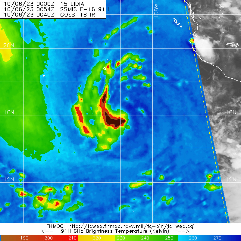
It does not look like shear is backing off as it now has a CCC. Not the healthiest of TCs right now. Mid level and low level circulations continue to be way off.
1 likes
RIP Kobe Bryant
-
Sciencerocks
- Category 5
- Posts: 10193
- Age: 40
- Joined: Thu Jul 06, 2017 1:51 am

-
cycloneye
- Admin
- Posts: 149702
- Age: 69
- Joined: Thu Oct 10, 2002 10:54 am
- Location: San Juan, Puerto Rico
Re: EPAC: LIDIA - Tropical Storm - Discussion
Tropical Storm Lidia Discussion Number 14
NWS National Hurricane Center Miami FL EP152023
900 AM MDT Fri Oct 06 2023
Lidia continues to produce very intense convection. Cloud tops as
cold as -95 deg C have been observed in the center of the main
convective mass during the past few hours. However, microwave data
from multiple polar-orbiting satellites during the past 6 hours
indicate that Lidia's center is not co-located with this convection.
Instead, the surface center appears to be displaced to the east,
with the tropical storm tilted by continued easterly shear. Recent
Dvorak estimates are not representative of this tilted structure, so
the intensity estimate is based more on the UW-CIMSS DPRINT, DMINT,
and SATCON techniques which incorporate microwave-based intensity
information. Based on those, the intensity remains 60 kt for this
advisory.
Although Lidia is tilted, its center is still obscured by the cirrus
canopy produced by its deep convection. Consequently, there is more
uncertainty than normal with the tropical storm's center location.
This is probably the largest source of uncertainty associated with
Lidia's track for the next 2 to 3 days. Lidia should move slowly
west-northwestward for the next day or so, and then gradually begin
to turn northward after that. After about 72 h, Lidia should begin
to accelerate northeastward, steered by a shortwave trough
approaching from the northwest. While the dynamical models agree
quite well on this general forecast, there is quite a bit of
disagreement on how fast Lidia will accelerate around day 4 and 5.
The NHC official track forecast has been nudged eastward, and lies
roughly halfway between the TVCN and HCCA consensus models.
Continued easterly wind shear should prevent significant
strengthening during the next few days. That said, if the center can
co-locate slightly better with the convection, even temporarily,
some strengthening is possible. Beginning around 72 h, the upper-air
environment will change, with the shear direction switching to
westerly and upper-level difluence likely increasing. However, Lidia
will be moving into a drier environment at the same time, and most
intensity models do not show much change in the winds at that time,
up or down. The official intensity forecast is very similar to the
previous one, and is higher than the model consensus in the short
term, in part out of respect to the higher-than-normal uncertainty
associated with Lidia's initial position and strength.
FORECAST POSITIONS AND MAX WINDS
INIT 06/1500Z 16.5N 110.3W 60 KT 70 MPH
12H 07/0000Z 16.6N 111.0W 70 KT 80 MPH
24H 07/1200Z 16.8N 112.0W 70 KT 80 MPH
36H 08/0000Z 17.0N 112.6W 65 KT 75 MPH
48H 08/1200Z 17.5N 113.1W 60 KT 70 MPH
60H 09/0000Z 18.2N 113.2W 60 KT 70 MPH
72H 09/1200Z 18.8N 112.5W 60 KT 70 MPH
96H 10/1200Z 19.5N 110.5W 60 KT 70 MPH
120H 11/1200Z 21.0N 108.0W 55 KT 65 MPH
$$
Forecaster D. Zelinsky
0 likes
Visit the Caribbean-Central America Weather Thread where you can find at first post web cams,radars
and observations from Caribbean basin members Click Here
and observations from Caribbean basin members Click Here
-
Kingarabian
- S2K Supporter
- Posts: 16377
- Joined: Sat Aug 08, 2009 3:06 am
- Location: Honolulu, Hawaii
Who is online
Users browsing this forum: No registered users and 80 guests