EPAC: LIDIA - Remnants - Discussion
Moderator: S2k Moderators
-
Kingarabian

- S2K Supporter

- Posts: 16378
- Joined: Sat Aug 08, 2009 3:06 am
- Location: Honolulu, Hawaii
Re: EPAC: LIDIA - Tropical Storm - Discussion
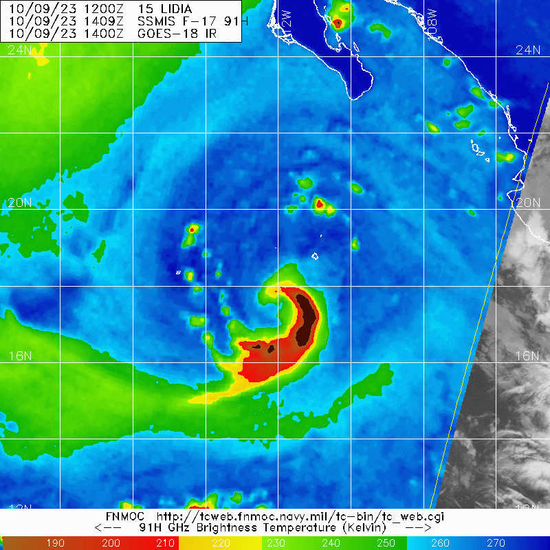
A lot better now, curved band is almost finished wrapping around. Strong winds likely in the eastern quad. Fortunately it is a large core on microwave that could limit the rate of intensification before landfall.
0 likes
RIP Kobe Bryant
-
Kingarabian
- S2K Supporter
- Posts: 16378
- Joined: Sat Aug 08, 2009 3:06 am
- Location: Honolulu, Hawaii
Re: EPAC: LIDIA - Tropical Storm - Discussion
Recon pretty much supports 65kts.
0 likes
RIP Kobe Bryant
-
Sciencerocks
- Category 5

- Posts: 10193
- Age: 40
- Joined: Thu Jul 06, 2017 1:51 am
-
Sciencerocks
- Category 5
- Posts: 10193
- Age: 40
- Joined: Thu Jul 06, 2017 1:51 am

-
Yellow Evan

- Professional-Met

- Posts: 16257
- Age: 27
- Joined: Fri Jul 15, 2011 12:48 pm
- Location: Henderson, Nevada/Honolulu, HI
- Contact:
Re: EPAC: LIDIA - Tropical Storm - Discussion
Convection is quickly rotating upshear. Shear has relaxed, last recon suggested deepening at a steady clip, and a favorable trough interaction has begun. I wouldn’t be surprised if this reached Category 3 before landfall.
2 likes
-
Netzero9455
- Tropical Low

- Posts: 19
- Joined: Sun Oct 23, 2016 6:23 pm
Re: EPAC: LIDIA - Tropical Storm - Discussion
Yellow Evan wrote:Convection is quickly rotating upshear. Shear has relaxed, last recon suggested deepening at a steady clip, and a favorable trough interaction has begun. I wouldn’t be surprised if this reached Category 3 before landfall.
Possible impacts in Puerto Vallarta proper? The angle of apporach means that if its core comes in close enough to the north of us, storm surge would pile into the Bay of Banderas....what's the lileihood of it coming in more to the south than currently predicted? Would its intensity have any impact on whether it comes in more to the north or not?
0 likes
-
cycloneye

- Admin

- Posts: 149703
- Age: 69
- Joined: Thu Oct 10, 2002 10:54 am
- Location: San Juan, Puerto Rico
Re: EPAC: LIDIA - Tropical Storm - Discussion
Tropical Storm Lidia Discussion Number 27
NWS National Hurricane Center Miami FL EP152023
300 PM MDT Mon Oct 09 2023
Satellite images indicate that Lidia is becoming better organized.
Deep convection is consolidating near the center and it appears that
an inner core is forming. In addition, a large curved band has
developed on the south and east sides of the circulation. The Air
Force Hurricane Hunters investigated Lidia earlier this afternoon
and found that the minimum pressure was quite low, around 985 mb. A
combination of the aircraft flight-level wind and SFMR data support
increasing the wind speed to 60 kt, and is possible that this is
conservative. The aircraft data and recent satellite images
suggest that the center has reformed to the south of the previous
positions.
Since the center of Lidia appears to have reformed, the initial
motion of 065/7 kt is uncertain. Water vapor images show a mid- to
upper-level trough approaching Lidia, and that feature should steer
the storm relatively quickly to the east-northeast toward
west-central Mexico. The main change for this forecast cycle is
associated with Lidia's reformation, which is roughly 1 degree south
of the previous estimates. Based on the initial position
adjustment, the new track forecast lies to the south of the previous
prediction. This forecast is close to the consensus aids and
roughly halfway between the fast GFS solution and the much slower
ECMWF run. Based on the new forecast, Lidia is expected to reach
the coast of Mexico Tuesday afternoon/evening.
Since Lidia appears to be developing an inner core while moving into
conducive environmental conditions, significant strengthening is
forecast. The storm is expected to move over SSTs near 30 C and
into a favorable upper-level wind pattern. The NHC intensity
forecast is similar to the previous one, and is in good agreement
with the hurricane regional models. Rapid weakening is forecast once
Lidia moves inland due to the rugged terrain in west-central Mexico.
Key Messages:
1. Lidia is forecast to strengthen before it reaches west-central
Mexico, and hurricane conditions are expected within the Hurricane
Warning area beginning Tuesday.
2. Heavy rains from Lidia will likely produce flash and urban
flooding, along with possible mudslides in areas of higher terrain
across the the state of Nayarit, southern portions of the state of
Sinaloa, and coastal portions of the state of Jalisco in western
Mexico.
3. A dangerous storm surge is expected near and to the south of
where the center of Lidia moves over the Islas Marias and the coast
of west-central Mexico.
4. Swells from Lidia will cause dangerous surf and rip current
conditions along the west coast of Mexico and the Baja California
peninsula during the next couple of days.
FORECAST POSITIONS AND MAX WINDS
INIT 09/2100Z 18.1N 110.9W 60 KT 70 MPH
12H 10/0600Z 18.7N 109.5W 75 KT 85 MPH
24H 10/1800Z 20.0N 107.2W 85 KT 100 MPH
36H 11/0600Z 21.8N 104.3W 40 KT 45 MPH...INLAND
48H 11/1800Z...DISSIPATED
$$
Forecaster Cangialosi
0 likes
Visit the Caribbean-Central America Weather Thread where you can find at first post web cams,radars
and observations from Caribbean basin members Click Here
and observations from Caribbean basin members Click Here

Re: EPAC: LIDIA - Tropical Storm - Discussion
Looks like it ate a bunch of dry air.
0 likes
Irene '11 Sandy '12 Hermine '16 5/15/2018 Derecho Fay '20 Isaias '20 Elsa '21 Henri '21 Ida '21
I am only a meteorology enthusiast who knows a decent amount about tropical cyclones. Look to the professional mets, the NHC, or your local weather office for the best information.
I am only a meteorology enthusiast who knows a decent amount about tropical cyclones. Look to the professional mets, the NHC, or your local weather office for the best information.
-
cycloneye
- Admin
- Posts: 149703
- Age: 69
- Joined: Thu Oct 10, 2002 10:54 am
- Location: San Juan, Puerto Rico
Re: EPAC: LIDIA - Tropical Storm - Discussion
Hurricane.
EP, 15, 2023101000, , BEST, 0, 182N, 1106W, 65, 983, HU
1 likes
Visit the Caribbean-Central America Weather Thread where you can find at first post web cams,radars
and observations from Caribbean basin members Click Here
and observations from Caribbean basin members Click Here
-
Sciencerocks
- Category 5
- Posts: 10193
- Age: 40
- Joined: Thu Jul 06, 2017 1:51 am

-
Sciencerocks
- Category 5
- Posts: 10193
- Age: 40
- Joined: Thu Jul 06, 2017 1:51 am
-
cycloneye
- Admin
- Posts: 149703
- Age: 69
- Joined: Thu Oct 10, 2002 10:54 am
- Location: San Juan, Puerto Rico
Re: EPAC: LIDIA - Hurricane - Discussion
Hurricane Lidia Discussion Number 28
NWS National Hurricane Center Miami FL EP152023
900 PM MDT Mon Oct 09 2023
Lidia has become better organized this evening, with an increase in
deep convection and banding near the center. An 0122 UTC SSMIS
microwave overpass revealed a well-defined mid-level center that
could be slight tilted from the low-level center. The upper-level
outflow has also become a little better established over the western
portion of the system. Subjective Dvorak data T-numbers from TAFB
and SAB are both T4.0 (65 kt), and the objective estimates are
close to that value as well. Based on the increase in organization
and recent subjective and objective estimates, the initial
intensity is raised to 65 kt, making Lidia a hurricane.
The initial motion estimate is east-northeast or 065 kt degrees at
9 kt. Lidia should accelerate east-northeastward ahead of mid- to
upper-level trough approaching from the northwest. On this
motion, the center of Lidia will approach the west-central coast of
Mexico on Tuesday. This storm is forecast to move inland along
the west-central coast of Mexico within the hurricane warning area
by Tuesday evening. The track guidance is in good agreement, but
it has again trended slightly south. The updated NHC forecast has
been nudged in that direction, and it lies close to the TVCE
multi-model consensus aid.
Low vertical wind shear and warm SSTs along the track of Lidia
is likely to allow for significant strengthening while the storm
heads toward west-central Mexico. The global and regional
dynamical models nearly unanimously call for significant deepening
during the next 12-24 hours, and the latest NHC intensity forecast
is a little higher than before. This is near the upper-end of the
interpolated intensity guidance, but a little lower than the raw
regional hurricane model output. Increasing shear near the time of
landfall, and interaction with land after Lidia moves onshore is
expected to result in rapid weakening and dissipation of the
cyclone by 48 hours.
Key Messages:
1. Lidia is now a hurricane and it is expected to continue to
strengthen as it approaches west-central Mexico on Tuesday.
Dangerous hurricane-force winds are expected within the Hurricane
Warning area beginning Tuesday afternoon.
2. Heavy rains from Lidia will likely produce flash and urban
flooding, along with possible mudslides in areas of higher terrain
across the the state of Nayarit, southern portions of the state of
Sinaloa, and coastal portions of the state of Jalisco in western
Mexico.
3. A dangerous storm surge is expected near and to the south of
where the center of Lidia moves onshore along the coast of
west-central Mexico.
4. Swells from Lidia will cause dangerous surf and rip current
conditions along the west coast of Mexico and the Baja California
peninsula during the next couple of days.
FORECAST POSITIONS AND MAX WINDS
INIT 10/0300Z 18.2N 110.2W 65 KT 75 MPH
12H 10/1200Z 19.1N 108.5W 80 KT 90 MPH
24H 11/0000Z 20.6N 105.9W 90 KT 105 MPH
36H 11/1200Z 22.5N 103.0W 35 KT 40 MPH...INLAND
48H 12/0000Z...DISSIPATED
$$
Forecaster Brown
0 likes
Visit the Caribbean-Central America Weather Thread where you can find at first post web cams,radars
and observations from Caribbean basin members Click Here
and observations from Caribbean basin members Click Here
-
Sciencerocks
- Category 5
- Posts: 10193
- Age: 40
- Joined: Thu Jul 06, 2017 1:51 am

-
cycloneye
- Admin
- Posts: 149703
- Age: 69
- Joined: Thu Oct 10, 2002 10:54 am
- Location: San Juan, Puerto Rico
Re: EPAC: LIDIA - Hurricane - Discussion
Hurricane Lidia Discussion Number 29
NWS National Hurricane Center Miami FL EP152023
300 AM MDT Tue Oct 10 2023
Lidia continues to have robust burst of convection this morning,
with cold cloud tops near -90 degrees Celsius. The recent
convective burst is near the well-defined mid-level core that was
depicted from an earlier SSMIS microwave pass. Subjective Dvorak
final T-numbers from TAFB and SAB are T4.0 (65 kt) and T4.5 (77 kt),
respectively. UW-CIMSS objective estimates range between 70-77 kt as
well. Based on the improved satellite imagery and recent
subjective and objective estimates, the initial intensity is raised
to 75 kt.
Lidia's estimated motion is east-northeast or 70 degrees at 10 kt.
The hurricane should move faster to the east-northeast later today
ahead of a mid- to upper-level trough advancing from the northwest.
The center of Lidia will approach the west-central coast of Mexico
later this afternoon and evening, with the system forecast to move
inland along the west-central coast of Mexico within the hurricane
warning area by tonight. The track guidance has once again trended
southward this cycle. The NHC forecast has been nudged further south
by about 20 n mi, and it lies close to the multi-model consensus
aids.
Low vertical wind shear and warm sea surface temperatures along the
track of Lidia should allow for further strengthening up until
landfall, consistent with the regional hurricane models and the
global model suite. While the 12 h intensity forecast of
90 kt is unchanged from the peak of the previous forecast (near the
upper-end of the intensity guidance), Lidia could intensify further
up to landfall. Increasing shear and the high terrain of Mexico
will result in rapid weakening after landfall and Lidia is expected
to dissipate by 36 hours.
Key Messages:
1. Lidia is expected to continue to strengthen as it approaches
west-central Mexico today. Dangerous hurricane-force winds are
expected within the Hurricane Warning area beginning this afternoon.
2. Heavy rains from Lidia will likely produce flash and urban
flooding, along with possible mudslides in areas of higher terrain
across the the state of Nayarit, southern portions of the state of
Sinaloa, and coastal portions of the state of Jalisco in western
Mexico.
3. A dangerous storm surge is expected near and to the south of
where the center of Lidia moves onshore along the coast of
west-central Mexico.
4. Swells from Lidia will cause dangerous surf and rip current
conditions along the west coast of Mexico and the Baja California
peninsula during the next couple of days.
FORECAST POSITIONS AND MAX WINDS
INIT 10/0900Z 18.6N 109.2W 75 KT 85 MPH
12H 10/1800Z 19.5N 107.2W 90 KT 105 MPH
24H 11/0600Z 21.1N 104.4W 45 KT 50 MPH...INLAND
36H 11/1800Z...DISSIPATED
$$
Forecaster Kelly
0 likes
Visit the Caribbean-Central America Weather Thread where you can find at first post web cams,radars
and observations from Caribbean basin members Click Here
and observations from Caribbean basin members Click Here
-
cycloneye
- Admin
- Posts: 149703
- Age: 69
- Joined: Thu Oct 10, 2002 10:54 am
- Location: San Juan, Puerto Rico
Re: EPAC: LIDIA - Hurricane - Discussion
0 likes
Visit the Caribbean-Central America Weather Thread where you can find at first post web cams,radars
and observations from Caribbean basin members Click Here
and observations from Caribbean basin members Click Here
-
Sciencerocks
- Category 5
- Posts: 10193
- Age: 40
- Joined: Thu Jul 06, 2017 1:51 am

-
cycloneye
- Admin
- Posts: 149703
- Age: 69
- Joined: Thu Oct 10, 2002 10:54 am
- Location: San Juan, Puerto Rico
Re: EPAC: LIDIA - Hurricane - Discussion
BULLETIN
Hurricane Lidia Intermediate Advisory Number 29A
NWS National Hurricane Center Miami FL EP152023
600 AM MDT Tue Oct 10 2023
...LIDIA FORECAST TO STRENGTHEN BEFORE LANDFALL IN WEST-CENTRAL
MEXICO...
...HURRICANE-FORCE WINDS AND FLOODING RAINS EXPECTED TO BEGIN THIS
AFTERNOON...
SUMMARY OF 600 AM MDT...1200 UTC...INFORMATION
----------------------------------------------
LOCATION...18.8N 108.3W
ABOUT 235 MI...380 KM WSW OF PUERTO VALLARTA MEXICO
MAXIMUM SUSTAINED WINDS...85 MPH...140 KM/H
PRESENT MOVEMENT...ENE OR 70 DEGREES AT 13 MPH...20 KM/H
MINIMUM CENTRAL PRESSURE...977 MB...28.85 INCHES
0 likes
Visit the Caribbean-Central America Weather Thread where you can find at first post web cams,radars
and observations from Caribbean basin members Click Here
and observations from Caribbean basin members Click Here
-
Yellow Evan
- Professional-Met
- Posts: 16257
- Age: 27
- Joined: Fri Jul 15, 2011 12:48 pm
- Location: Henderson, Nevada/Honolulu, HI
- Contact:

-
cycloneye
- Admin
- Posts: 149703
- Age: 69
- Joined: Thu Oct 10, 2002 10:54 am
- Location: San Juan, Puerto Rico
Re: EPAC: LIDIA - Hurricane - Discussion
EP, 15, 2023101012, , BEST, 0, 189N, 1084W, 80, 973, HU
0 likes
Visit the Caribbean-Central America Weather Thread where you can find at first post web cams,radars
and observations from Caribbean basin members Click Here
and observations from Caribbean basin members Click Here
-
Yellow Evan
- Professional-Met
- Posts: 16257
- Age: 27
- Joined: Fri Jul 15, 2011 12:48 pm
- Location: Henderson, Nevada/Honolulu, HI
- Contact:
Re: EPAC: LIDIA - Hurricane - Discussion
10/1200 UTC 18.6N 108.7W T5.0/5.0 LIDIA -- East Pacific
0 likes
Who is online
Users browsing this forum: No registered users and 69 guests