

Iota and Eta were less than 3 years ago. It's a very small part of the basin comparatively. Expecting activity there every year is crazy. It's a the right place, right time kinda thing.Ianswfl wrote:MarioProtVI wrote:WalterWhite wrote:Hyperactivity is very much possible. The mean OND ACE for 2013-2022 is 34.9. If the Atlantic just adds 30 more ACE for the rest of the season (which is BELOW the mean), we would already have about 156 ACE, which is quite close to the hyperactivity threshold.
Octobers for the most part of the last decade sans 2016, 2018 and 2020 have been underwhelming, since the Caribbean doesn’t seem to want to produce any major hurricanes, meaning the best shot is in the subtropics. Just because models say October is favorable doesn’t mean it’ll be active, I’ve see this part happen over and over again - where people expect a decent October and it ends up producing either weak sloppy TSs or short lived C1s in the subtropics, both which generate on average only 3-5 ACE. I don’t expect 2023 to deviate from that especially with El Niño. So no, hyperactivity is dead in the water and people seem to be -removed-.
The other question is why isn't the Caribbean producing the large in size monster cat4s and cat5s like they did in the past despite being so active and warm the Atl these days?
I mean like your Ivan's, Gilbert's, Wilmas, Dennis, Mitch, Isidore. When we do get a cat4 or cat5 in the Caribbean Sea now they seem to be more compact in size and not the insane 180mph monsters like Mitch.
I mean bombing out in the Caribbean, not waiting until getting into the Gulf like Michael or Ian to reach their peak.
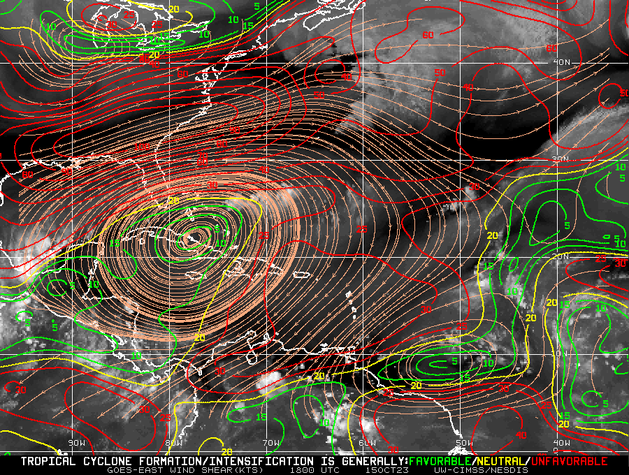
2023 Indicators (SST, SAL, MSLP, Wind shear, Steering, Instability) and Day 16+ Models
Moderator: S2k Moderators
Forum rules

The posts in this forum are NOT official forecasts and should not be used as such. They are just the opinion of the poster and may or may not be backed by sound meteorological data. They are NOT endorsed by any professional institution or STORM2K. For official information, please refer to products from the National Hurricane Center and National Weather Service.
Re: 2023 Indicators (SST, SAL, MSLP, Wind shear, Steering, Instability) and Day 16+ Models
0 likes
Re: 2023 Indicators (SST, SAL, MSLP, Wind shear, Steering, Instability) and Day 16+ Models
Woofde wrote:Iota and Eta were less than 3 years ago. It's a very small part of the basin comparatively. Expecting activity there every year is crazy. It's a the right place, right time kinda thing.Ianswfl wrote:MarioProtVI wrote:Octobers for the most part of the last decade sans 2016, 2018 and 2020 have been underwhelming, since the Caribbean doesn’t seem to want to produce any major hurricanes, meaning the best shot is in the subtropics. Just because models say October is favorable doesn’t mean it’ll be active, I’ve see this part happen over and over again - where people expect a decent October and it ends up producing either weak sloppy TSs or short lived C1s in the subtropics, both which generate on average only 3-5 ACE. I don’t expect 2023 to deviate from that especially with El Niño. So no, hyperactivity is dead in the water and people seem to be -removed-.
The other question is why isn't the Caribbean producing the large in size monster cat4s and cat5s like they did in the past despite being so active and warm the Atl these days?
I mean like your Ivan's, Gilbert's, Wilmas, Dennis, Mitch, Isidore. When we do get a cat4 or cat5 in the Caribbean Sea now they seem to be more compact in size and not the insane 180mph monsters like Mitch.
I mean bombing out in the Caribbean, not waiting until getting into the Gulf like Michael or Ian to reach their peak.
Yea, but those were still fairly compact in size. For 2020 being so active you'd think they'd been a lot stronger. Intensities in the 2020 season underachieved IMO. Didn't get those Irma and Wilma looking storms. We're not seeing storms in the Caribbean that are large and resemble super typhoons like in the past. Mitch and also Wilma after her EWRC looked more like a super typhoon. 2005 those hurricanes in the western Atl looked more like super typhoons than Atlantic hurricanes!
1 likes
-
ElectricStorm

- Category 5

- Posts: 5153
- Age: 25
- Joined: Tue Aug 13, 2019 11:23 pm
- Location: Norman, OK
Re: 2023 Indicators (SST, SAL, MSLP, Wind shear, Steering, Instability) and Day 16+ Models
Ianswfl wrote:Woofde wrote:Iota and Eta were less than 3 years ago. It's a very small part of the basin comparatively. Expecting activity there every year is crazy. It's a the right place, right time kinda thing.Ianswfl wrote:
The other question is why isn't the Caribbean producing the large in size monster cat4s and cat5s like they did in the past despite being so active and warm the Atl these days?
I mean like your Ivan's, Gilbert's, Wilmas, Dennis, Mitch, Isidore. When we do get a cat4 or cat5 in the Caribbean Sea now they seem to be more compact in size and not the insane 180mph monsters like Mitch.
I mean bombing out in the Caribbean, not waiting until getting into the Gulf like Michael or Ian to reach their peak.
Yea, but those were still fairly compact in size. For 2020 being so active you'd think they'd been a lot stronger. Intensities in the 2020 season underachieved IMO. Didn't get those Irma and Wilma looking storms. We're not seeing storms in the Caribbean that are large and resemble super typhoons like in the past. Mitch and also Wilma after her EWRC looked more like a super typhoon. 2005 those hurricanes in the western Atl looked more like super typhoons than Atlantic hurricanes!
I mean storms like Irma and Wilma in the Atlantic are very rare, you can't really expect something like that to happen very often
5 likes
B.S Meteorology, University of Oklahoma '25
Please refer to the NHC, NWS, or SPC for official information.
Please refer to the NHC, NWS, or SPC for official information.
-
WalterWhite

- Category 1

- Posts: 342
- Joined: Fri Mar 17, 2023 5:53 pm
Re: 2023 Indicators (SST, SAL, MSLP, Wind shear, Steering, Instability) and Day 16+ Models
I would also like to point out that while absolute MDR SST anomalies might indicate a Moderate/Strong El Nino (+1.4 C at the moment), MDR SST anomalies RELATIVE TO global tropic SST anomalies indicate a warm-neutral/Weak El Nino (+0.7 C at the moment). While this year might be technically a Moderate/Strong El Nino year, it will probably function like a warm-neutral or Weak El Nino year. In that sense, exceeding the 126 ACE threshold is not particularly impressive, given that there have been warm-neutral years (relative to the global tropics) that have featured above-average Atlantic hurricane seasons.
0 likes
-
WeatherBoy2000
- Category 1
- Posts: 463
- Joined: Mon Apr 10, 2023 9:29 am
Re: 2023 Indicators (SST, SAL, MSLP, Wind shear, Steering, Instability) and Day 16+ Models
Ianswfl wrote:Woofde wrote:Iota and Eta were less than 3 years ago. It's a very small part of the basin comparatively. Expecting activity there every year is crazy. It's a the right place, right time kinda thing.Ianswfl wrote:
The other question is why isn't the Caribbean producing the large in size monster cat4s and cat5s like they did in the past despite being so active and warm the Atl these days?
I mean like your Ivan's, Gilbert's, Wilmas, Dennis, Mitch, Isidore. When we do get a cat4 or cat5 in the Caribbean Sea now they seem to be more compact in size and not the insane 180mph monsters like Mitch.
I mean bombing out in the Caribbean, not waiting until getting into the Gulf like Michael or Ian to reach their peak.
Yea, but those were still fairly compact in size. For 2020 being so active you'd think they'd been a lot stronger. Intensities in the 2020 season underachieved IMO. Didn't get those Irma and Wilma looking storms. We're not seeing storms in the Caribbean that are large and resemble super typhoons like in the past. Mitch and also Wilma after her EWRC looked more like a super typhoon. 2005 those hurricanes in the western Atl looked more like super typhoons than Atlantic hurricanes!
2005 is hardly representative of any normal Atlantic hurricane season, past nor present, it was an extremely active/rare Atlantic hurricane season. It's the type of season you expect to see once every several decades. I don't get how you can say 2020 underachieved, especially in the late season, there isn't really a season comparable to 2020's late season Caribbean/gulf activity. 5 major hurricanes from October-November is extremely anomalous (admittedly one was in the subtropics).
9 likes
-
tolakram
- Admin

- Posts: 20186
- Age: 62
- Joined: Sun Aug 27, 2006 8:23 pm
- Location: Florence, KY (name is Mark)
Re: 2023 Indicators (SST, SAL, MSLP, Wind shear, Steering, Instability) and Day 16+ Models
Once again it seems we fall down on what impressive means. There's also a lot of recency bias.
X starts paying attention to hurricane season when Y happens.
In the following seasons when Y does not repeat the season is unimpressive or somehow abnormal.
If two or three seasons "under perform" based on Y then then something major has changed.
Each season is unique, and we never really know how the season will unfold until it does. Short sightedness, in hurricane season terms, can be less than 20 years, quite possibly longer.
13 likes
M a r k
- - - - -
Join us in chat: Storm2K Chatroom Invite. Android and IOS apps also available.
The posts in this forum are NOT official forecasts and should not be used as such. Posts are NOT endorsed by any professional institution or STORM2K.org. For official information and forecasts, please refer to NHC and NWS products.

Re: 2023 Indicators (SST, SAL, MSLP, Wind shear, Steering, Instability) and Day 16+ Models
Ianswfl wrote:MarioProtVI wrote:WalterWhite wrote:Hyperactivity is very much possible. The mean OND ACE for 2013-2022 is 34.9. If the Atlantic just adds 30 more ACE for the rest of the season (which is BELOW the mean), we would already have about 156 ACE, which is quite close to the hyperactivity threshold.
Octobers for the most part of the last decade sans 2016, 2018 and 2020 have been underwhelming, since the Caribbean doesn’t seem to want to produce any major hurricanes, meaning the best shot is in the subtropics. Just because models say October is favorable doesn’t mean it’ll be active, I’ve see this part happen over and over again - where people expect a decent October and it ends up producing either weak sloppy TSs or short lived C1s in the subtropics, both which generate on average only 3-5 ACE. I don’t expect 2023 to deviate from that especially with El Niño. So no, hyperactivity is dead in the water and people seem to be -removed-.
The other question is why isn't the Caribbean producing the large in size monster cat4s and cat5s like they did in the past despite being so active and warm the Atl these days?
I mean like your Ivan's, Gilbert's, Wilmas, Dennis, Mitch, Isidore. When we do get a cat4 or cat5 in the Caribbean Sea now they seem to be more compact in size and not the insane 180mph monsters like Mitch.
I mean bombing out in the Caribbean, not waiting until getting into the Gulf like Michael or Ian to reach their peak.
Iota was the same size roughly as Dennis (and stronger), Eta was larger (and also stronger) and Mitch was smaller than any of the storms listed as far as size, so it could arguably fall into the 'relatively compact' category.
Matthew in 2016 was also quite large once the rapid easterly flow to the north died down.
1 likes
The above post is not official and should not be used as such. It is the opinion of the poster and may or may not be backed by sound meteorological data. It is not endorsed by any professional institution or storm2k.org. For official information, please refer to the NHC and NWS products.
-
WalterWhite
- Category 1
- Posts: 342
- Joined: Fri Mar 17, 2023 5:53 pm
Re: 2023 Indicators (SST, SAL, MSLP, Wind shear, Steering, Instability) and Day 16+ Models
tolakram wrote:Once again it seems we fall down on what impressive means. There's also a lot of recency bias.
X starts paying attention to hurricane season when Y happens.
In the following seasons when Y does not repeat the season is unimpressive or somehow abnormal.
If two or three seasons "under perform" based on Y then then something major has changed.
Each season is unique, and we never really know how the season will unfold until it does. Short sightedness, in hurricane season terms, can be less than 20 years, quite possibly longer.
There are factors that STRONGLY influence hurricane seasons. La Nina seasons tend to have stronger peak and late seasons that El Nino seasons. Seasons that buck these trends must be investigated, and doing so could reveal useful information for future hurricane seasons: examples include the very weak late seasons for 2007 and 2021, and the impressive peak season for 2004.
When a season bucks a general trend, it must be investigated. There is ALWAYS a reason might overperform or underperform in a specific way relative to seasons with season patterns; chalking it up to the "uniqueness" of each season is antithetical to scientific research.
3 likes
-
tolakram
- Admin
- Posts: 20186
- Age: 62
- Joined: Sun Aug 27, 2006 8:23 pm
- Location: Florence, KY (name is Mark)
Re: 2023 Indicators (SST, SAL, MSLP, Wind shear, Steering, Instability) and Day 16+ Models
WalterWhite wrote:tolakram wrote:Once again it seems we fall down on what impressive means. There's also a lot of recency bias.
X starts paying attention to hurricane season when Y happens.
In the following seasons when Y does not repeat the season is unimpressive or somehow abnormal.
If two or three seasons "under perform" based on Y then then something major has changed.
Each season is unique, and we never really know how the season will unfold until it does. Short sightedness, in hurricane season terms, can be less than 20 years, quite possibly longer.
There are factors that STRONGLY influence hurricane seasons. La Nina seasons tend to have stronger peak and late seasons that El Nino seasons. Seasons that buck these trends must be investigated, and doing so could reveal useful information for future hurricane seasons: examples include the very weak late seasons for 2007 and 2021, and the impressive peak season for 2004.
When a season bucks a general trend, it must be investigated. There is ALWAYS a reason might overperform or underperform in a specific way relative to seasons with season patterns; chalking it up to the "uniqueness" of each season is antithetical to scientific research.
What trends? How long are these trends? Who is NOT investigating? I find unexpected seasons fascinating and I've said this for years, but this has nothing to do with what I posted.
1 likes
M a r k
- - - - -
Join us in chat: Storm2K Chatroom Invite. Android and IOS apps also available.
The posts in this forum are NOT official forecasts and should not be used as such. Posts are NOT endorsed by any professional institution or STORM2K.org. For official information and forecasts, please refer to NHC and NWS products.
- - - - -
Join us in chat: Storm2K Chatroom Invite. Android and IOS apps also available.
The posts in this forum are NOT official forecasts and should not be used as such. Posts are NOT endorsed by any professional institution or STORM2K.org. For official information and forecasts, please refer to NHC and NWS products.
-
CyclonicFury

- Category 5
- Posts: 2038
- Age: 27
- Joined: Sun Jul 02, 2017 12:32 pm
- Location: NC
- Contact:
Re: 2023 Indicators (SST, SAL, MSLP, Wind shear, Steering, Instability) and Day 16+ Models
This season has really quieted down since mid-September. Nigel underperformed, and Philippe failed to even get to 50kt. 92L will probably be a weak TS at most due to a limited window of favorable conditions. The subtropical jet has really ramped up, shutting down the Gulf of Mexico. Makes me wonder if we'll see another hurricane or not at this point.
2 likes
NCSU B.S. in Meteorology Class of 2021. Tropical weather blogger at http://www.cyclonicfury.com. My forecasts and thoughts are NOT official, for official forecasts please consult the National Hurricane Center.
-
MarioProtVI
- Category 5
- Posts: 1039
- Age: 24
- Joined: Sun Sep 29, 2019 7:33 pm
- Location: New Jersey
Re: 2023 Indicators (SST, SAL, MSLP, Wind shear, Steering, Instability) and Day 16+ Models
CyclonicFury wrote:This season has really quieted down since mid-September. Nigel underperformed, and Philippe failed to even get to 50kt. 92L will probably be a weak TS at most due to a limited window of favorable conditions. The subtropical jet has really ramped up, shutting down the Gulf of Mexico. Makes me wonder if we'll see another hurricane or not at this point.
Probably El Niño finally coupling with the atmosphere in late September if I were to guess, before definitely doing so now (see the last 24 hours in the Pacific). It’s quite possible Nigel could’ve been the last hurricane although personally I believe it was very briefly Ophelia.
2 likes
-
WeatherBoy2000
- Category 1
- Posts: 463
- Joined: Mon Apr 10, 2023 9:29 am
Re: 2023 Indicators (SST, SAL, MSLP, Wind shear, Steering, Instability) and Day 16+ Models
https://twitter.com/AndyHazelton/status/1712091375599043049
https://twitter.com/yconsor/status/1712132070988738834
https://twitter.com/AndyHazelton/status/1712136548664189031
I'd be careful saying that this season is truly winding down (outside or what's climatologically expected). There's a decent signal for another storm after Sean, one that might have better conditions to work with. Models indicate shear lowering for the second half of October in the Caribbean and western mdr. This isn't typical for a strong el nino, and the mdr activity is atypical in general.
8 likes
-
hurricanetrack

- HurricaneTrack.com
- Posts: 1781
- Joined: Tue Dec 02, 2003 10:46 pm
- Location: Wilmington, NC
- Contact:
Re: 2023 Indicators (SST, SAL, MSLP, Wind shear, Steering, Instability) and Day 16+ Models
I included this thread in today's video discussion. Very interesting to see the CV season extending as long as it is. Makes me think that 2024 will pick up real quick....but this is 2023, so we shall deal with that first I guess.
[youtube]https://youtu.be/l6JKV5dE_YU[/youtube]
[youtube]https://youtu.be/l6JKV5dE_YU[/youtube]
8 likes

-
Deshaunrob17
- Tropical Storm

- Posts: 211
- Joined: Tue Aug 18, 2020 7:49 am
Re: 2023 Indicators (SST, SAL, MSLP, Wind shear, Steering, Instability) and Day 16+ Models
Shear is usually the problem with October storms in the MDR, dry air is usually not . Would be interesting to see what happens with reduced shear and extra warm waters this year.
1 likes
-
CyclonicFury
- Category 5
- Posts: 2038
- Age: 27
- Joined: Sun Jul 02, 2017 12:32 pm
- Location: NC
- Contact:
Re: 2023 Indicators (SST, SAL, MSLP, Wind shear, Steering, Instability) and Day 16+ Models
A couple days ago, models suggested 94L could become an unprecedented mid-October Cabo Verde hurricane, now its development is looking less certain and a hurricane is starting to appear unlikely. Seems like that October Nino shutdown Andy Hazelton speculated is happening after all. We haven't had a single hurricane since September 22; if no more hurricanes form Nigel will be the earliest last hurricane in the basin since 2013.
3 likes
NCSU B.S. in Meteorology Class of 2021. Tropical weather blogger at http://www.cyclonicfury.com. My forecasts and thoughts are NOT official, for official forecasts please consult the National Hurricane Center.


Re: 2023 Indicators (SST, SAL, MSLP, Wind shear, Steering, Instability) and Day 16+ Models
CyclonicFury wrote:A couple days ago, models suggested 94L could become an unprecedented mid-October Cabo Verde hurricane, now its development is looking less certain and a hurricane is starting to appear unlikely. Seems like that October Nino shutdown Andy Hazelton speculated is happening after all. We haven't had a single hurricane since September 22; if no more hurricanes form Nigel will be the earliest last hurricane in the basin since 2013.
Who else would have thought that? So much untapped heat energy in the Caribbean and not an excess amount of shear, just unfavorable upper level winds. Doubt we will see much more the next 6 weeks.
1 likes
-
Iceresistance

- Category 5
- Posts: 9605
- Age: 22
- Joined: Sat Oct 10, 2020 9:45 am
- Location: Tecumseh, OK/Norman, OK
Re: 2023 Indicators (SST, SAL, MSLP, Wind shear, Steering, Instability) and Day 16+ Models
3 likes
Bill 2015 & Beta 2020
Winter 2020-2021
All observations are in Tecumseh, OK unless otherwise noted.
Winter posts are focused mainly for Oklahoma & Texas.
Take any of my forecasts with a grain of salt, refer to the NWS, SPC, and NHC for official information
Never say Never with weather! Because ANYTHING is possible!
Winter 2020-2021
All observations are in Tecumseh, OK unless otherwise noted.
Winter posts are focused mainly for Oklahoma & Texas.
Take any of my forecasts with a grain of salt, refer to the NWS, SPC, and NHC for official information
Never say Never with weather! Because ANYTHING is possible!

Re: 2023 Indicators (SST, SAL, MSLP, Wind shear, Steering, Instability) and Day 16+ Models
CyclonicFury wrote:A couple days ago, models suggested 94L could become an unprecedented mid-October Cabo Verde hurricane, now its development is looking less certain and a hurricane is starting to appear unlikely. Seems like that October Nino shutdown Andy Hazelton speculated is happening after all. We haven't had a single hurricane since September 22; if no more hurricanes form Nigel will be the earliest last hurricane in the basin since 2013.
We’ll see what happens to 94L. But regardless, El Niño says “I’m in charge now and have been for awhile!” In reality though, it has thankfully been in charge all season as far as tracks are concerned with only one TC moving W or WNW west of 74W! That’s extra impressive considering the higher than average number of storms. Thanks largely to El Niño, the mean Bermuda high has been significantly weaker than average, a common feature of El Niño. As a result, the bulk of the tracks W of 50W have been more dominated by NW to NE headings than W to WNW headings.
1 likes
Personal Forecast Disclaimer:
The posts in this forum are NOT official forecasts and should not be used as such. They are just the opinion of the poster and may or may not be backed by sound meteorological data. They are NOT endorsed by any professional institution or storm2k.org. For official information, please refer to the NHC and NWS products.
The posts in this forum are NOT official forecasts and should not be used as such. They are just the opinion of the poster and may or may not be backed by sound meteorological data. They are NOT endorsed by any professional institution or storm2k.org. For official information, please refer to the NHC and NWS products.