JMA now at 900 hPa / 115 knots
JMA expects the peak to reach 895 hPa / 120 knots
WPAC: BOLAVEN - Post-Tropical
Moderator: S2k Moderators
-
mrbagyo

- Category 5

- Posts: 4002
- Age: 33
- Joined: Thu Apr 12, 2012 9:18 am
- Location: 14.13N 120.98E
- Contact:
Re: WPAC: BOLAVEN - Typhoon
0 likes
The posts in this forum are NOT official forecast and should not be used as such. They are just the opinion of the poster and may or may not be backed by sound meteorological data. They are NOT endorsed by any professional institution or storm2k.org. For official information, please refer to RSMC, NHC and NWS products.

Re: WPAC: BOLAVEN - Typhoon
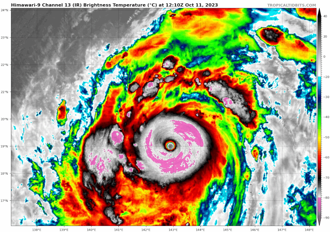
15W BOLAVEN 231011 1200 18.9N 142.9E WPAC 155 904
edit: pressure corrected to 904
Last edited by Hayabusa on Wed Oct 11, 2023 8:18 am, edited 1 time in total.
0 likes
ヤンデレ女が寝取られるているのを見たい!!!
ECMWF ensemble NWPAC plots: https://ecmwfensnwpac.imgbb.com/
Multimodel NWPAC plots: https://multimodelnwpac.imgbb.com/
GFS Ensemble NWPAC plots (16 & 35 day forecast): https://gefsnwpac.imgbb.com/
Plots updated automatically
ECMWF ensemble NWPAC plots: https://ecmwfensnwpac.imgbb.com/
Multimodel NWPAC plots: https://multimodelnwpac.imgbb.com/
GFS Ensemble NWPAC plots (16 & 35 day forecast): https://gefsnwpac.imgbb.com/
Plots updated automatically
Re: WPAC: BOLAVEN - Typhoon
It would be the first sub 900 since Surigae unless JMA reanalyzes Mawar
T2315(Bolaven)
Issued at 2023/10/11 12:45 UTC
Analysis at 10/11 12 UTC
Grade TY
Scale Large
Intensity Violent
Center position N18°55′ (18.9°)
E143°00′ (143.0°)
Direction and speed of movement NNW 15 km/h (9 kt)
Central pressure 900 hPa
Maximum sustained wind speed near center 60 m/s (115 kt)
Maximum wind gust speed 85 m/s (165 kt)
Radius of 50-kt wind area 120 km (65 NM)
Radius of 30-kt wind area 560 km (300 NM)
Forecast for 10/12 00 UTC
Grade TY
Intensity Violent
Center position of probability circle N20°35′ (20.6°)
E143°00′ (143.0°)
Direction and speed of movement N 15 km/h (9 kt)
Central pressure 895 hPa
Maximum sustained wind speed near center 60 m/s (120 kt)
Maximum wind gust speed 85 m/s (170 kt)
Radius of probability circle 55 km (30 NM)
Radius of storm warning area 200 km (110 NM)
0 likes
ヤンデレ女が寝取られるているのを見たい!!!
ECMWF ensemble NWPAC plots: https://ecmwfensnwpac.imgbb.com/
Multimodel NWPAC plots: https://multimodelnwpac.imgbb.com/
GFS Ensemble NWPAC plots (16 & 35 day forecast): https://gefsnwpac.imgbb.com/
Plots updated automatically
ECMWF ensemble NWPAC plots: https://ecmwfensnwpac.imgbb.com/
Multimodel NWPAC plots: https://multimodelnwpac.imgbb.com/
GFS Ensemble NWPAC plots (16 & 35 day forecast): https://gefsnwpac.imgbb.com/
Plots updated automatically
-
mrbagyo
- Category 5
- Posts: 4002
- Age: 33
- Joined: Thu Apr 12, 2012 9:18 am
- Location: 14.13N 120.98E
- Contact:
Re: WPAC: BOLAVEN - Typhoon

bullseye pass
1 likes
The posts in this forum are NOT official forecast and should not be used as such. They are just the opinion of the poster and may or may not be backed by sound meteorological data. They are NOT endorsed by any professional institution or storm2k.org. For official information, please refer to RSMC, NHC and NWS products.
Re: WPAC: BOLAVEN - Typhoon
HFAS 06Z init 144kts@878mb

0 likes
ヤンデレ女が寝取られるているのを見たい!!!
ECMWF ensemble NWPAC plots: https://ecmwfensnwpac.imgbb.com/
Multimodel NWPAC plots: https://multimodelnwpac.imgbb.com/
GFS Ensemble NWPAC plots (16 & 35 day forecast): https://gefsnwpac.imgbb.com/
Plots updated automatically
ECMWF ensemble NWPAC plots: https://ecmwfensnwpac.imgbb.com/
Multimodel NWPAC plots: https://multimodelnwpac.imgbb.com/
GFS Ensemble NWPAC plots (16 & 35 day forecast): https://gefsnwpac.imgbb.com/
Plots updated automatically

Re: WPAC: BOLAVEN - Typhoon
1 likes
TC naming lists: retirements and intensity
Most aggressive Advisory #1's in North Atlantic (cr. kevin for starting the list)
Most aggressive Advisory #1's in North Atlantic (cr. kevin for starting the list)

Re: WPAC: BOLAVEN - Typhoon
mrbagyo wrote:https://i.imgur.com/upcu0SV.png
bullseye pass
What are the max winds this pass recorded?
0 likes
Irene '11 Sandy '12 Hermine '16 5/15/2018 Derecho Fay '20 Isaias '20 Elsa '21 Henri '21 Ida '21
I am only a meteorology enthusiast who knows a decent amount about tropical cyclones. Look to the professional mets, the NHC, or your local weather office for the best information.
I am only a meteorology enthusiast who knows a decent amount about tropical cyclones. Look to the professional mets, the NHC, or your local weather office for the best information.
-
mrbagyo
- Category 5
- Posts: 4002
- Age: 33
- Joined: Thu Apr 12, 2012 9:18 am
- Location: 14.13N 120.98E
- Contact:
Re: WPAC: BOLAVEN - Typhoon
aspen wrote:mrbagyo wrote:https://i.imgur.com/upcu0SV.png
bullseye pass
What are the max winds this pass recorded?
155 knots (300m - level 2)
https://twitter.com/zeb199818/status/1712079876025631124
147 knots at 3km resolution

2 likes
The posts in this forum are NOT official forecast and should not be used as such. They are just the opinion of the poster and may or may not be backed by sound meteorological data. They are NOT endorsed by any professional institution or storm2k.org. For official information, please refer to RSMC, NHC and NWS products.
-
Sciencerocks
- Category 5
- Posts: 10194
- Age: 40
- Joined: Thu Jul 06, 2017 1:51 am

Re: WPAC: BOLAVEN - Typhoon
Wow,.what a beauty! It's that time of year that we start getting the monsters in El Nino years... Oct-Nov
0 likes
Georges '98, Irene '99, Frances '04, Jeanne '04, Katrina '05, Wilma '05, Gustav '08, Isaac '12, Matthew '16, Florence '18, Michael '18, Ian '22
-
cycloneye

- Admin

- Posts: 149843
- Age: 69
- Joined: Thu Oct 10, 2002 10:54 am
- Location: San Juan, Puerto Rico
Re: WPAC: BOLAVEN - Typhoon
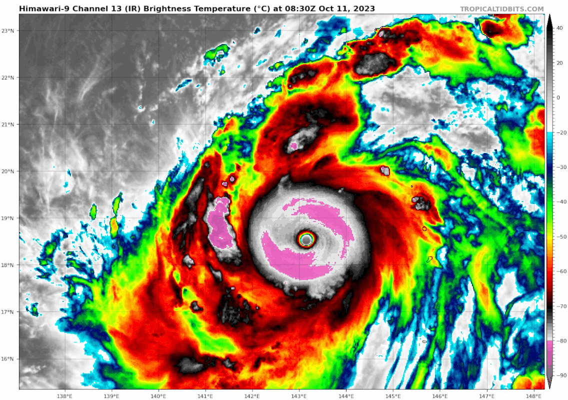
Wow. This is one of the most symmetrical systems I have seen in my lifetime.

6 likes
Visit the Caribbean-Central America Weather Thread where you can find at first post web cams,radars
and observations from Caribbean basin members Click Here
and observations from Caribbean basin members Click Here
-
mrbagyo
- Category 5
- Posts: 4002
- Age: 33
- Joined: Thu Apr 12, 2012 9:18 am
- Location: 14.13N 120.98E
- Contact:
Re: WPAC: BOLAVEN - Typhoon
Bolaven has already maintained an eye temp greater than 20°C for 14 consecutive hrs on the Himawari-9. whoaw.
1 likes
The posts in this forum are NOT official forecast and should not be used as such. They are just the opinion of the poster and may or may not be backed by sound meteorological data. They are NOT endorsed by any professional institution or storm2k.org. For official information, please refer to RSMC, NHC and NWS products.
-
mrbagyo
- Category 5
- Posts: 4002
- Age: 33
- Joined: Thu Apr 12, 2012 9:18 am
- Location: 14.13N 120.98E
- Contact:
Re: WPAC: BOLAVEN - Typhoon
JMA maintains its 900 hPa / 115 knots estimate on their 15z fix
0 likes
The posts in this forum are NOT official forecast and should not be used as such. They are just the opinion of the poster and may or may not be backed by sound meteorological data. They are NOT endorsed by any professional institution or storm2k.org. For official information, please refer to RSMC, NHC and NWS products.
Re: WPAC: BOLAVEN - Typhoon (current peak JTWC=155kt, JMA=900mb)
0 likes
TC naming lists: retirements and intensity
Most aggressive Advisory #1's in North Atlantic (cr. kevin for starting the list)
Most aggressive Advisory #1's in North Atlantic (cr. kevin for starting the list)
-
StormTracker89
- Tropical Depression

- Posts: 57
- Joined: Sat May 16, 2020 3:47 pm
- Location: Somewhere in the Pacific
Re: WPAC: BOLAVEN - Typhoon
Foxfires wrote:StormTracker89 wrote:aspen wrote:How much you wanna bet this is never operationally classified as a Cat 5?
I'll bet you a lot!
You lost lol
Afraid not.
0 likes
-
Hurricane2022

- Category 5
- Posts: 2096
- Joined: Tue Aug 23, 2022 11:38 pm
- Location: Araçatuba, Brazil
Re: WPAC: BOLAVEN - Typhoon (current peak JTWC=155kt, JMA=900mb)
1 likes
Sorry for the bad English sometimes...!
For reliable and detailed information for any meteorological phenomenon, please consult the National Hurricane Center, Joint Typhoon Warning Center , or your local Meteo Center.
--------
ECCE OMNIA NOVA FACIAM (Ap 21,5).
For reliable and detailed information for any meteorological phenomenon, please consult the National Hurricane Center, Joint Typhoon Warning Center , or your local Meteo Center.
--------
ECCE OMNIA NOVA FACIAM (Ap 21,5).
-
Sciencerocks
- Category 5
- Posts: 10194
- Age: 40
- Joined: Thu Jul 06, 2017 1:51 am
Re: WPAC: BOLAVEN - Typhoon (current peak JTWC=155kt, JMA=900mb)
I am going to estimate that this peaked at ~160 knts/884mbs(+- 5mb's)
0 likes
-
MarioProtVI
- Category 5
- Posts: 1039
- Age: 24
- Joined: Sun Sep 29, 2019 7:33 pm
- Location: New Jersey
Re: WPAC: BOLAVEN - Typhoon (current peak JTWC=155kt, JMA=900mb)
Sciencerocks wrote:I am going to estimate that this peaked at ~160 knts/884mbs(+- 5mb's)
I think a more probable peak is around 170 kt/881 mb. Remember, Dorian in the Atlantic was 160 kt but on satellite looked like your average 115 kt storm.
3 likes
-
StormChaser75

- Tropical Storm

- Posts: 101
- Age: 24
- Joined: Sat Feb 06, 2016 4:23 pm
- Location: Corpus Christi TX
- Contact:

-
Hurricane2022
- Category 5
- Posts: 2096
- Joined: Tue Aug 23, 2022 11:38 pm
- Location: Araçatuba, Brazil
Re: WPAC: BOLAVEN - Typhoon (current peak JTWC=155kt, JMA=900mb)
Oh. My. God.


Last edited by Hurricane2022 on Wed Nov 15, 2023 1:57 pm, edited 1 time in total.
4 likes
Sorry for the bad English sometimes...!
For reliable and detailed information for any meteorological phenomenon, please consult the National Hurricane Center, Joint Typhoon Warning Center , or your local Meteo Center.
--------
ECCE OMNIA NOVA FACIAM (Ap 21,5).
For reliable and detailed information for any meteorological phenomenon, please consult the National Hurricane Center, Joint Typhoon Warning Center , or your local Meteo Center.
--------
ECCE OMNIA NOVA FACIAM (Ap 21,5).
Who is online
Users browsing this forum: No registered users and 19 guests