EPAC: LIDIA - Remnants - Discussion
Moderator: S2k Moderators
-
Kingarabian

- S2K Supporter

- Posts: 16379
- Joined: Sat Aug 08, 2009 3:06 am
- Location: Honolulu, Hawaii
Re: EPAC: LIDIA - Hurricane - Discussion update: 140 mph / Makes Landfall
Lol I was away all day and it finally did this. Prayers out to those in its way. Wow it came quite a long considering the dry air and shear it faced just 24 hours ago.
1 likes
RIP Kobe Bryant
-
Sciencerocks
- Category 5

- Posts: 10193
- Age: 40
- Joined: Thu Jul 06, 2017 1:51 am
-
cycloneye

- Admin

- Posts: 149730
- Age: 69
- Joined: Thu Oct 10, 2002 10:54 am
- Location: San Juan, Puerto Rico
Re: EPAC: LIDIA - Hurricane - Discussion
Hurricane Lidia Discussion Number 32
NWS National Hurricane Center Miami FL EP152023
1000 PM CDT Tue Oct 10 2023
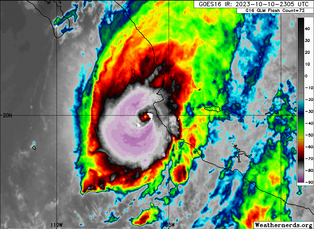
Lidia is estimated to have made landfall around 2350 UTC near Las
Penitas in the Mexican state of Jalisco. Satellite imagery showed
an eye briefly clearing and warming before reaching the coastline,
and the maximum sustained wind speed was estimated to be 120 kt.
Since that time, the structure of Lidia has degraded. The eye is
no longer apparent and convection around the center is no longer
symmetric. The initial intensity for this advisory is lowered to
90 kt. Continued rapid weakening is expected for the next day
while Lidia moves over the elevated terrain in west-central Mexico.
Model guidance shows the storm will dissipate within 24 hours, and
this is reflected in the official intensity forecast.
The hurricane's motion is estimated to be 60/15 kt. Lidia is
expected to accelerate northeastward in the flow of a mid- to
upper-level trough located over northern Mexico. Minor adjustments
have been made to the NHC track forecast. Even as Lidia dissipates,
remnant moisture could result in flooding rainfall and possible
mudslides as it moves inland.
Key Messages:
1. Lidia is moving inland over west-central Mexico as a hurricane.
Life-threatening hurricane-force winds are expected along the path
of the storm overnight.
2. Heavy rains from Lidia will likely produce flash and urban
flooding, along with possible mudslides in areas of higher terrain
across the state of Nayarit, southern portions of the state of
Sinaloa, and coastal portions of the state of Jalisco in western
Mexico.
3. Dangerous water levels along the coast of west-central Mexico
will gradually subside overnight.
4. Swells from Lidia will cause dangerous surf and rip current
conditions along the west coast of Mexico and the Baja California
peninsula through Wednesday.
FORECAST POSITIONS AND MAX WINDS
INIT 11/0300Z 20.6N 104.7W 90 KT 105 MPH
12H 11/1200Z 22.1N 102.2W 35 KT 40 MPH...INLAND
24H 12/0000Z...DISSIPATED
$$
Forecaster Bucci
NWS National Hurricane Center Miami FL EP152023
1000 PM CDT Tue Oct 10 2023
Lidia is estimated to have made landfall around 2350 UTC near Las
Penitas in the Mexican state of Jalisco. Satellite imagery showed
an eye briefly clearing and warming before reaching the coastline,
and the maximum sustained wind speed was estimated to be 120 kt.
Since that time, the structure of Lidia has degraded. The eye is
no longer apparent and convection around the center is no longer
symmetric. The initial intensity for this advisory is lowered to
90 kt. Continued rapid weakening is expected for the next day
while Lidia moves over the elevated terrain in west-central Mexico.
Model guidance shows the storm will dissipate within 24 hours, and
this is reflected in the official intensity forecast.
The hurricane's motion is estimated to be 60/15 kt. Lidia is
expected to accelerate northeastward in the flow of a mid- to
upper-level trough located over northern Mexico. Minor adjustments
have been made to the NHC track forecast. Even as Lidia dissipates,
remnant moisture could result in flooding rainfall and possible
mudslides as it moves inland.
Key Messages:
1. Lidia is moving inland over west-central Mexico as a hurricane.
Life-threatening hurricane-force winds are expected along the path
of the storm overnight.
2. Heavy rains from Lidia will likely produce flash and urban
flooding, along with possible mudslides in areas of higher terrain
across the state of Nayarit, southern portions of the state of
Sinaloa, and coastal portions of the state of Jalisco in western
Mexico.
3. Dangerous water levels along the coast of west-central Mexico
will gradually subside overnight.
4. Swells from Lidia will cause dangerous surf and rip current
conditions along the west coast of Mexico and the Baja California
peninsula through Wednesday.
FORECAST POSITIONS AND MAX WINDS
INIT 11/0300Z 20.6N 104.7W 90 KT 105 MPH
12H 11/1200Z 22.1N 102.2W 35 KT 40 MPH...INLAND
24H 12/0000Z...DISSIPATED
$$
Forecaster Bucci
0 likes
Visit the Caribbean-Central America Weather Thread where you can find at first post web cams,radars
and observations from Caribbean basin members Click Here
and observations from Caribbean basin members Click Here
-
Sciencerocks
- Category 5
- Posts: 10193
- Age: 40
- Joined: Thu Jul 06, 2017 1:51 am
-
Netzero9455
- Tropical Low

- Posts: 19
- Joined: Sun Oct 23, 2016 6:23 pm
Re: EPAC: LIDIA - Hurricane - Discussion
Fortunately here in Puerto Vallarta we got the north side coming from the mountains, I lost a pair of polycarbonate skylights only. I would estimate max wind gusts to be around 100km/h , and steady date not exceeding 75 or so. If it had come 50 km to the north it could have been a true disaster with All the storm surge funneling into the bay. No power, internet or running water since about 5 hours ago but all in all seems like we dodged a huge bullet yet again. One day we won't be so lucky anymore I predict....
1 likes
-
cycloneye
- Admin
- Posts: 149730
- Age: 69
- Joined: Thu Oct 10, 2002 10:54 am
- Location: San Juan, Puerto Rico
Re: EPAC: LIDIA - Remnants - Discussion
Remnants Of Lidia Discussion Number 33
NWS National Hurricane Center Miami FL EP152023
400 AM CDT Wed Oct 11 2023
The satellite structure of Lidia has rapidly deteriorated overnight
over the mountainous terrain of western Mexico. Surface observations
and satellite data indicate the system no longer has a well-defined
center, and therefore this will be the final NHC advisory on Lidia.
Even though the system has dissipated, moisture associated with
Lidia's remnants could result in additional heavy rainfall and
flooding over portions of western Mexico today.
Key Messages:
1. Additional rainfall associated with the remnants of Lidia may
produce flash and urban flooding across portions of western Mexico
today, along with possible mudslides in areas of higher terrain near
the coast.
FORECAST POSITIONS AND MAX WINDS
INIT 11/0900Z 22.5N 102.5W 30 KT 35 MPH...REMNANTS OF LIDIA
12H 11/1800Z...DISSIPATED
$$
Forecaster Reinhart
1 likes
Visit the Caribbean-Central America Weather Thread where you can find at first post web cams,radars
and observations from Caribbean basin members Click Here
and observations from Caribbean basin members Click Here
-
Sciencerocks
- Category 5
- Posts: 10193
- Age: 40
- Joined: Thu Jul 06, 2017 1:51 am
-
cycloneye
- Admin
- Posts: 149730
- Age: 69
- Joined: Thu Oct 10, 2002 10:54 am
- Location: San Juan, Puerto Rico
Re: EPAC: LIDIA - Remnants - Discussion
1 likes
Visit the Caribbean-Central America Weather Thread where you can find at first post web cams,radars
and observations from Caribbean basin members Click Here
and observations from Caribbean basin members Click Here
Who is online
Users browsing this forum: No registered users and 35 guests