https://twitter.com/sayakasofiamori/status/1712217024477437971
WPAC: BOLAVEN - Post-Tropical
Moderator: S2k Moderators

Re: WPAC: BOLAVEN - Typhoon
mrbagyo wrote:https://i.imgur.com/upcu0SV.png
bullseye pass
I checked the 500m data, and it’s clear that the wind speeds are artificially capped at 80.0 m/s, so there is a low bias.
0 likes
-
mrbagyo

- Category 5

- Posts: 4003
- Age: 33
- Joined: Thu Apr 12, 2012 9:18 am
- Location: 14.13N 120.98E
- Contact:
Re: WPAC: BOLAVEN - Typhoon (current peak JTWC=155kt, JMA=900mb)
The eyewall is still thick and intense on the last 2 microwaves


0 likes
The posts in this forum are NOT official forecast and should not be used as such. They are just the opinion of the poster and may or may not be backed by sound meteorological data. They are NOT endorsed by any professional institution or storm2k.org. For official information, please refer to RSMC, NHC and NWS products.
-
doomhaMwx

- Category 5
- Posts: 2496
- Age: 27
- Joined: Tue Apr 18, 2017 4:01 am
- Location: Baguio/Benguet, Philippines
- Contact:
Re: WPAC: BOLAVEN - Typhoon (current peak JTWC=155kt, JMA=900mb)
It did look like concentric eyewalls were present on microwave data at ~16Z, particularly on 37 GHz frequency which scans the low levels, but it's incredible how we still have yet to see an EWRC actually happen.
(FY-3D MWRI images courtesy of Dapiya)


(FY-3D MWRI images courtesy of Dapiya)
0 likes
-
doomhaMwx
- Category 5
- Posts: 2496
- Age: 27
- Joined: Tue Apr 18, 2017 4:01 am
- Location: Baguio/Benguet, Philippines
- Contact:
Re: WPAC: BOLAVEN - Typhoon (current peak JTWC=155kt, JMA=900mb)
Latest microwave scan finally shows a legit EWRC, and cloud tops around the eye have significantly warmed up as a result.


0 likes

Re: WPAC: BOLAVEN - Typhoon (current peak JTWC=155kt, JMA=900mb)
Looks stronger than 900 millibars.
0 likes
-
doomhaMwx
- Category 5
- Posts: 2496
- Age: 27
- Joined: Tue Apr 18, 2017 4:01 am
- Location: Baguio/Benguet, Philippines
- Contact:
Re: WPAC: BOLAVEN - Typhoon (current peak JTWC=155kt, JMA=900mb)
15W BOLAVEN 231012 0000 20.6N 143.0E WPAC 150 908
0 likes
-
mrbagyo
- Category 5
- Posts: 4003
- Age: 33
- Joined: Thu Apr 12, 2012 9:18 am
- Location: 14.13N 120.98E
- Contact:
Re: WPAC: BOLAVEN - Typhoon (current peak JTWC=155kt, JMA=900mb)
15W BOLAVEN 231012 0600 21.8N 143.5E WPAC 155 905
They'll probably revise this
They'll probably revise this
0 likes
The posts in this forum are NOT official forecast and should not be used as such. They are just the opinion of the poster and may or may not be backed by sound meteorological data. They are NOT endorsed by any professional institution or storm2k.org. For official information, please refer to RSMC, NHC and NWS products.
-
doomhaMwx
- Category 5
- Posts: 2496
- Age: 27
- Joined: Tue Apr 18, 2017 4:01 am
- Location: Baguio/Benguet, Philippines
- Contact:
Re: WPAC: BOLAVEN - Typhoon (current peak JTWC=155kt, JMA=900mb)
Interesting that JTWC bumped up the intensity back to 155kts after giving 150kts at 00Z, especially now that the system is in the midst of an EWRC.


Huh, JTWC in its 09Z prognostic reasoning says that EWRC has been completed. That ~06Z MW image definitely says otherwise.
15W BOLAVEN 231012 0600 21.8N 143.5E WPAC 155 905
15W BOLAVEN 231012 0000 20.6N 143.0E WPAC 150 908
15W BOLAVEN 231011 1800 19.7N 142.9E WPAC 155 903
15W BOLAVEN 231012 0000 20.6N 143.0E WPAC 150 908
15W BOLAVEN 231011 1800 19.7N 142.9E WPAC 155 903
Huh, JTWC in its 09Z prognostic reasoning says that EWRC has been completed. That ~06Z MW image definitely says otherwise.
SATELLITE ANALYSIS, INITIAL POSITION AND INTENSITY DISCUSSION:
ANIMATED ENHANCED INFRARED (EIR) SATELLITE IMAGERY SHOWS THE SYSTEM
HAS COMPLETED AN EYEWALL REPLACEMENT AND HAS RE-INTENSIFIED IN THE
LAST FEW HOURS, SPORTING A NEW SHARPLY-OUTLINED 13-NM EYE. THE
INITIAL POSITION IS PLACED WITH HIGH CONFIDENCE BASED ON THE EYE IN
THE EIR LOOP AND SPOT ON WITH A MICROWAVE EYE FEATURE IN THE
120613Z SSMIS 37GHZ IMAGE. THE INITIAL INTENSITY OF 155KTS IS ALSO
PLACED WITH HIGH CONFIDENCE BASED ON THE DVORAK ESTIMATES FROM
PGTW, KNES, AND RJTD AND REFLECTS THE 6-HR IMPROVEMENT.
0 likes

Re: WPAC: BOLAVEN - Typhoon (current peak JTWC=155kt, JMA=900mb)
Bolaven’s persistence is quite impressive. It’s been holding on to a fantastic structure for so long despite an EWRC trying to start for the last 12+ hours. I would’ve expected the eye to have collapsed by now.
I think this could’ve hit 160 kt. That 8z SAR pass from yesterday found 155 kt at its 300m resolution, so assuming there could’ve been some undersampling, 160 kt seems possible, especially when Bolaven’s eye hit 26C. Maybe 165 kt is possible. However, I think 155 kt is a fair estimate based on Dvorak (once it finally caught up) and the SAR pass. The pressure was probably deep into the 890s.
I think this could’ve hit 160 kt. That 8z SAR pass from yesterday found 155 kt at its 300m resolution, so assuming there could’ve been some undersampling, 160 kt seems possible, especially when Bolaven’s eye hit 26C. Maybe 165 kt is possible. However, I think 155 kt is a fair estimate based on Dvorak (once it finally caught up) and the SAR pass. The pressure was probably deep into the 890s.
1 likes
Irene '11 Sandy '12 Hermine '16 5/15/2018 Derecho Fay '20 Isaias '20 Elsa '21 Henri '21 Ida '21
I am only a meteorology enthusiast who knows a decent amount about tropical cyclones. Look to the professional mets, the NHC, or your local weather office for the best information.
I am only a meteorology enthusiast who knows a decent amount about tropical cyclones. Look to the professional mets, the NHC, or your local weather office for the best information.
-
mrbagyo
- Category 5
- Posts: 4003
- Age: 33
- Joined: Thu Apr 12, 2012 9:18 am
- Location: 14.13N 120.98E
- Contact:
Re: WPAC: BOLAVEN - Typhoon (current peak JTWC=155kt, JMA=900mb)
Wow, It's still at 155 knots / 905 hPa at 12z
15W BOLAVEN 231012 1200 22.6N 144.3E WPAC 155 905
15W BOLAVEN 231012 1200 22.6N 144.3E WPAC 155 905
0 likes
The posts in this forum are NOT official forecast and should not be used as such. They are just the opinion of the poster and may or may not be backed by sound meteorological data. They are NOT endorsed by any professional institution or storm2k.org. For official information, please refer to RSMC, NHC and NWS products.
-
mrbagyo
- Category 5
- Posts: 4003
- Age: 33
- Joined: Thu Apr 12, 2012 9:18 am
- Location: 14.13N 120.98E
- Contact:
Re: WPAC: BOLAVEN - Typhoon (current peak JTWC=155kt, JMA=900mb)
Fresh microwave still shows a very intense inner core.
looks like a gigantic Fibonacci spiral


looks like a gigantic Fibonacci spiral
2 likes
The posts in this forum are NOT official forecast and should not be used as such. They are just the opinion of the poster and may or may not be backed by sound meteorological data. They are NOT endorsed by any professional institution or storm2k.org. For official information, please refer to RSMC, NHC and NWS products.
-
doomhaMwx
- Category 5
- Posts: 2496
- Age: 27
- Joined: Tue Apr 18, 2017 4:01 am
- Location: Baguio/Benguet, Philippines
- Contact:
Re: WPAC: BOLAVEN - Typhoon (current peak JTWC=155kt, JMA=900mb)
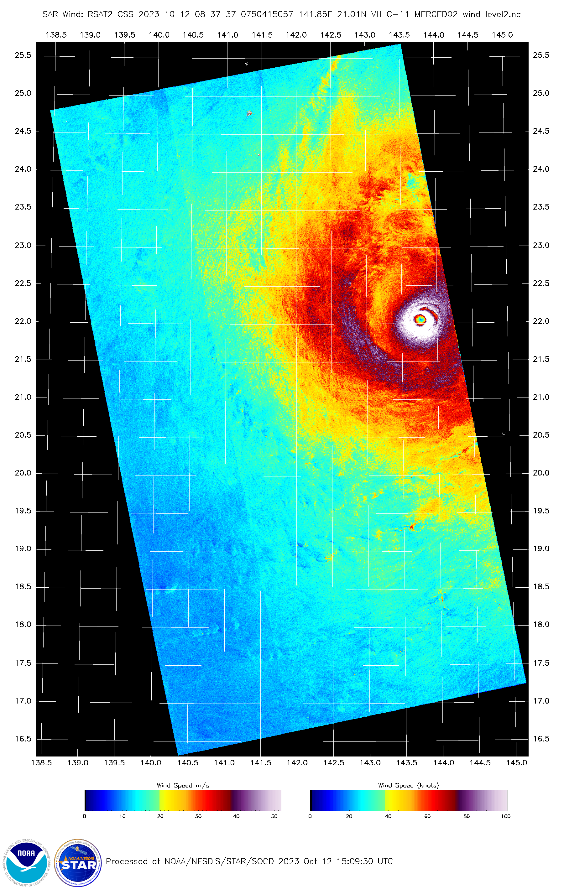
SAR pass at ~08Z found 155kts.

0 likes
-
Sciencerocks
- Category 5
- Posts: 10194
- Age: 40
- Joined: Thu Jul 06, 2017 1:51 am

Re: WPAC: BOLAVEN - Typhoon (current peak JTWC=155kt, JMA=900mb)
169 kts from AMSU @ 1012/11z

0 likes
ヤンデレ女が寝取られるているのを見たい!!!
ECMWF ensemble NWPAC plots: https://ecmwfensnwpac.imgbb.com/
Multimodel NWPAC plots: https://multimodelnwpac.imgbb.com/
GFS Ensemble NWPAC plots (16 & 35 day forecast): https://gefsnwpac.imgbb.com/
Plots updated automatically
ECMWF ensemble NWPAC plots: https://ecmwfensnwpac.imgbb.com/
Multimodel NWPAC plots: https://multimodelnwpac.imgbb.com/
GFS Ensemble NWPAC plots (16 & 35 day forecast): https://gefsnwpac.imgbb.com/
Plots updated automatically
Re: WPAC: BOLAVEN - Typhoon (current peak JTWC=155kt, JMA=900mb)
This has to be the lowest init yet since HFSA began operations. 853 and 855 mb


1 likes
ヤンデレ女が寝取られるているのを見たい!!!
ECMWF ensemble NWPAC plots: https://ecmwfensnwpac.imgbb.com/
Multimodel NWPAC plots: https://multimodelnwpac.imgbb.com/
GFS Ensemble NWPAC plots (16 & 35 day forecast): https://gefsnwpac.imgbb.com/
Plots updated automatically
ECMWF ensemble NWPAC plots: https://ecmwfensnwpac.imgbb.com/
Multimodel NWPAC plots: https://multimodelnwpac.imgbb.com/
GFS Ensemble NWPAC plots (16 & 35 day forecast): https://gefsnwpac.imgbb.com/
Plots updated automatically
Re: WPAC: BOLAVEN - Typhoon (current peak JTWC=155kt, JMA=900mb)
doomhaMwx wrote:SAR pass at ~08Z found 155kts.
https://www.star.nesdis.noaa.gov/socd/mecb/sar/AKDEMO_products/APL_winds/tropical/2023/WP152023_BOLAVEN/RSAT2_GSS_2023_10_12_08_37_37_0750415057_141.85E_21.01N_VH_C-11_MERGED02_RadialWinds_4Quads_3.0km.png
https://www.star.nesdis.noaa.gov/socd/mecb/sar/AKDEMO_products/APL_winds/tropical/2023/WP152023_BOLAVEN/RSAT2_GSS_2023_10_12_08_37_37_0750415057_141.85E_21.01N_VH_C-11_MERGED02_wind.png
It took me 5 seconds to realise it’s 08Z of the 12th, not the 11th lol, Bolaven has maintained its intensity too well
0 likes
-
doomhaMwx
- Category 5
- Posts: 2496
- Age: 27
- Joined: Tue Apr 18, 2017 4:01 am
- Location: Baguio/Benguet, Philippines
- Contact:
Re: WPAC: BOLAVEN - Typhoon (current peak JTWC=155kt, JMA=900mb)
Downgraded below category 5 for the first time in two days.
15W BOLAVEN 231013 0000 25.4N 146.9E WPAC 130 923
T2315(Bolaven)
Issued at 2023/10/13 00:50 UTC
Analysis at 10/13 00 UTC
Grade TY
Scale Large
Intensity Violent
Center position N25°25′ (25.4°)
E146°55′ (146.9°)
Direction and speed of movement NE 35 km/h (20 kt)
Central pressure 915 hPa
Maximum sustained wind speed near center 55 m/s (105 kt)
Maximum wind gust speed 75 m/s (150 kt)
Radius of 50-kt wind area 200 km (110 NM)
Radius of 30-kt wind area E560 km (300 NM)
W440 km (240 NM)
2 likes

Re: WPAC: BOLAVEN - Typhoon
So.. EWRC or no? latest microwave passes don't exactly look EWRC-y anymore but I'm no expert.
0 likes
-
StormTracker89
- Tropical Depression

- Posts: 57
- Joined: Sat May 16, 2020 3:47 pm
- Location: Somewhere in the Pacific
Re: WPAC: BOLAVEN - Typhoon (current peak JTWC=155kt, JMA=900mb)
doomhaMwx wrote:It did look like concentric eyewalls were present on microwave data at ~16Z, particularly on 37 GHz frequency which scans the low levels, but it's incredible how we still have yet to see an EWRC actually happen.
(FY-3D MWRI images courtesy of Dapiya)
https://i.imgur.com/tfNXtrM.png
https://i.imgur.com/kjyW57g.png
Are these FY-3D MWRI images posted anywhere publicly available?
0 likes
Who is online
Users browsing this forum: No registered users and 20 guests