

BULLETIN
Tropical Storm Norma Advisory Number 1
NWS National Hurricane Center Miami FL EP172023
300 PM MDT Tue Oct 17 2023
...TROPICAL STORM NORMA DEVELOPS IN THE EASTERN PACIFIC...
SUMMARY OF 300 PM MDT...2100 UTC...INFORMATION
----------------------------------------------
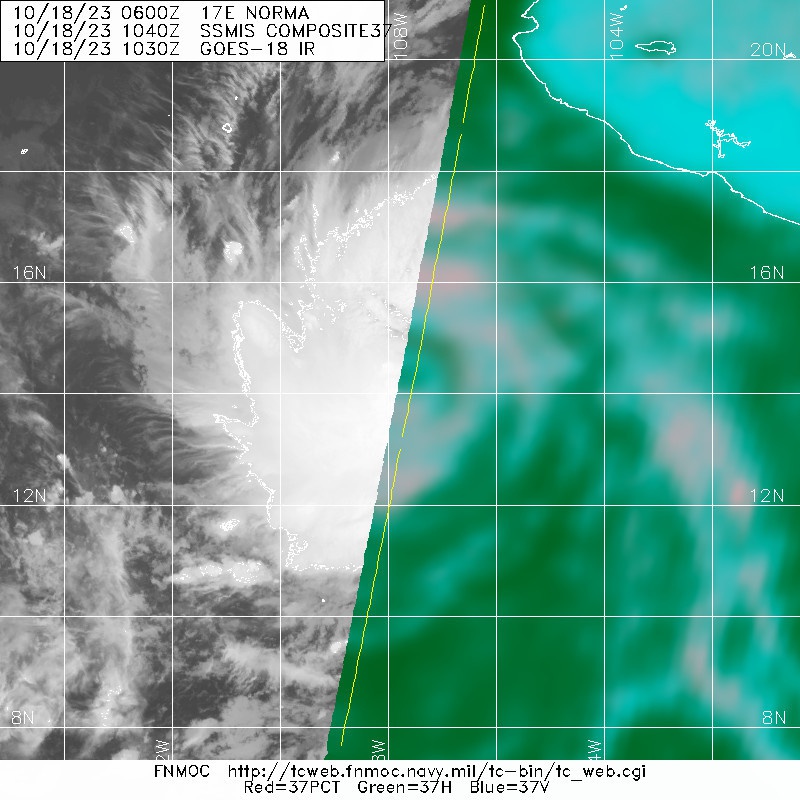
LOCATION...13.2N 107.3W
ABOUT 445 MI...720 KM SSW OF MANZANILLO MEXICO
ABOUT 690 MI...1110 KM SSE OF CABO SAN LUCAS MEXICO
MAXIMUM SUSTAINED WINDS...40 MPH...65 KM/H
PRESENT MOVEMENT...WNW OR 285 DEGREES AT 10 MPH...17 KM/H
MINIMUM CENTRAL PRESSURE...1004 MB...29.65 INCHES
TCDEP2
Tropical Storm Norma Discussion Number 1
NWS National Hurricane Center Miami FL EP172023
300 PM MDT Tue Oct 17 2023
Satellite imagery this afternoon depicts that the area the National
Hurricane Center has been monitoring offshore of the southwestern
coast of Mexico (EP90) has become better organized. Showers and
thunderstorms have been consolidating, with curved band features
developing around a recently well-defined low-level center.
Subjective Dvorak satellite intensity estimates are T2.5/T3.0 from
TAFB and SAB, respectively. Given the improved satellite
presentation and these intensity estimates, advisories are being
initiated on Tropical Storm Norma with an initial intensity of 35
kt.
Norma is in a fairly conducive environment for intensification. Low
vertical wind shear, warm sea surface temperatures, and favorable
upper-level diffluence will likely lead to steady to rapid
strengthening for the next few days. DTOPS and SHIPS rapid
intensification (RI) indices are between 60 to 70 percent for a 55
kt increase over the next 48 hours, and the NHC forecast is near
that value, explicitly forecasting RI between 12 to 36 hours.
Towards the end of the forecast, increasing vertical wind shear and
potential drier air intrusions could cause the system to gradually
weaken. The NHC forecast lies just below the HCCA HFIP corrected
consensus aids, and it is noted that the HAFS-A/B hurricane regional
models show a higher, but still plausible, peak intensity.
Norma is moving west-northwestward at an estimated motion of 285/9
kt. The system is expected to turn more northwestward at a slightly
slower forward speed during the next few days around the western
periphery of a mid-level ridge. Towards the end of the forecast
period as the system moves toward the Baja peninsula, there is a
notable divergence among the model suite. A stronger vortex, as
depicted in the GFS/CMC model, would be picked up by an approaching
trough from the northwest and move the system northeastward towards
the Baja peninsula. However, a weaker vortex would tend to meander
south of the peninsula and be missed by the approaching trough,
like the ECMWF/UKMET solutions. Since the NHC intensity forecast
is on the strong side of the guidance, the official track is closer
to the right side of the guidance envelope, more similar to the GFS
and HCCA models.
FORECAST POSITIONS AND MAX WINDS
INIT 17/2100Z 13.2N 107.3W 35 KT 40 MPH
12H 18/0600Z 13.8N 108.0W 45 KT 50 MPH
24H 18/1800Z 15.0N 108.4W 60 KT 70 MPH
36H 19/0600Z 16.0N 108.6W 75 KT 85 MPH
48H 19/1800Z 16.9N 108.8W 85 KT 100 MPH
60H 20/0600Z 17.8N 109.1W 95 KT 110 MPH
72H 20/1800Z 18.7N 109.6W 95 KT 110 MPH
96H 21/1800Z 20.9N 110.3W 90 KT 105 MPH
120H 22/1800Z 22.5N 110.0W 85 KT 100 MPH
$$
Forecaster Kelly
Tropical Storm Norma Advisory Number 1
NWS National Hurricane Center Miami FL EP172023
300 PM MDT Tue Oct 17 2023
...TROPICAL STORM NORMA DEVELOPS IN THE EASTERN PACIFIC...
SUMMARY OF 300 PM MDT...2100 UTC...INFORMATION
----------------------------------------------
LOCATION...13.2N 107.3W
ABOUT 445 MI...720 KM SSW OF MANZANILLO MEXICO
ABOUT 690 MI...1110 KM SSE OF CABO SAN LUCAS MEXICO
MAXIMUM SUSTAINED WINDS...40 MPH...65 KM/H
PRESENT MOVEMENT...WNW OR 285 DEGREES AT 10 MPH...17 KM/H
MINIMUM CENTRAL PRESSURE...1004 MB...29.65 INCHES
TCDEP2
Tropical Storm Norma Discussion Number 1
NWS National Hurricane Center Miami FL EP172023
300 PM MDT Tue Oct 17 2023
Satellite imagery this afternoon depicts that the area the National
Hurricane Center has been monitoring offshore of the southwestern
coast of Mexico (EP90) has become better organized. Showers and
thunderstorms have been consolidating, with curved band features
developing around a recently well-defined low-level center.
Subjective Dvorak satellite intensity estimates are T2.5/T3.0 from
TAFB and SAB, respectively. Given the improved satellite
presentation and these intensity estimates, advisories are being
initiated on Tropical Storm Norma with an initial intensity of 35
kt.
Norma is in a fairly conducive environment for intensification. Low
vertical wind shear, warm sea surface temperatures, and favorable
upper-level diffluence will likely lead to steady to rapid
strengthening for the next few days. DTOPS and SHIPS rapid
intensification (RI) indices are between 60 to 70 percent for a 55
kt increase over the next 48 hours, and the NHC forecast is near
that value, explicitly forecasting RI between 12 to 36 hours.
Towards the end of the forecast, increasing vertical wind shear and
potential drier air intrusions could cause the system to gradually
weaken. The NHC forecast lies just below the HCCA HFIP corrected
consensus aids, and it is noted that the HAFS-A/B hurricane regional
models show a higher, but still plausible, peak intensity.
Norma is moving west-northwestward at an estimated motion of 285/9
kt. The system is expected to turn more northwestward at a slightly
slower forward speed during the next few days around the western
periphery of a mid-level ridge. Towards the end of the forecast
period as the system moves toward the Baja peninsula, there is a
notable divergence among the model suite. A stronger vortex, as
depicted in the GFS/CMC model, would be picked up by an approaching
trough from the northwest and move the system northeastward towards
the Baja peninsula. However, a weaker vortex would tend to meander
south of the peninsula and be missed by the approaching trough,
like the ECMWF/UKMET solutions. Since the NHC intensity forecast
is on the strong side of the guidance, the official track is closer
to the right side of the guidance envelope, more similar to the GFS
and HCCA models.
FORECAST POSITIONS AND MAX WINDS
INIT 17/2100Z 13.2N 107.3W 35 KT 40 MPH
12H 18/0600Z 13.8N 108.0W 45 KT 50 MPH
24H 18/1800Z 15.0N 108.4W 60 KT 70 MPH
36H 19/0600Z 16.0N 108.6W 75 KT 85 MPH
48H 19/1800Z 16.9N 108.8W 85 KT 100 MPH
60H 20/0600Z 17.8N 109.1W 95 KT 110 MPH
72H 20/1800Z 18.7N 109.6W 95 KT 110 MPH
96H 21/1800Z 20.9N 110.3W 90 KT 105 MPH
120H 22/1800Z 22.5N 110.0W 85 KT 100 MPH
$$
Forecaster Kelly


