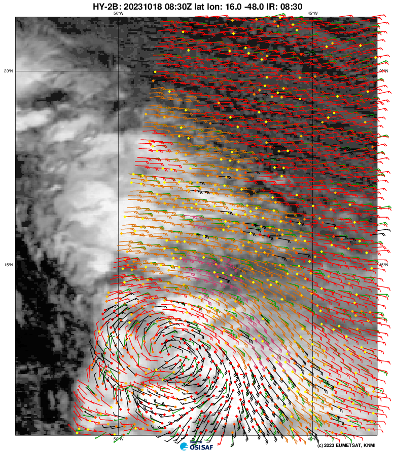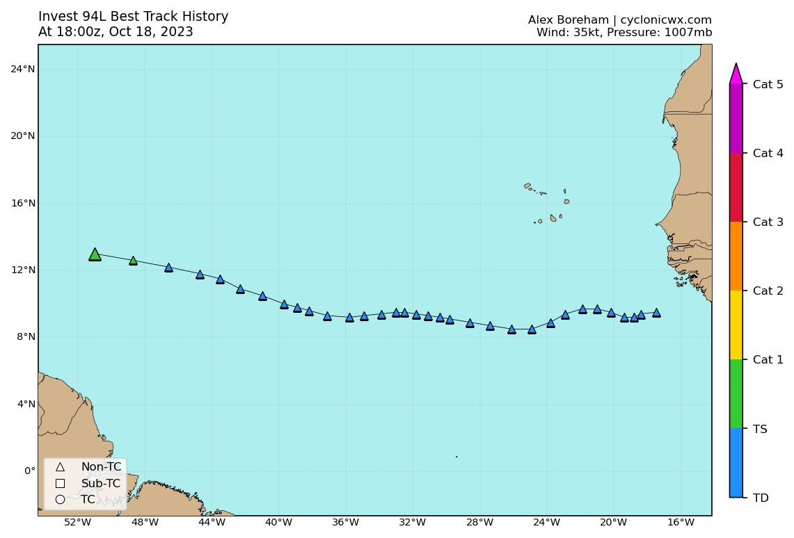
ATL: TAMMY - Post-Tropical - Discussion
Moderator: S2k Moderators
- cycloneye
- Admin

- Posts: 149712
- Age: 69
- Joined: Thu Oct 10, 2002 10:54 am
- Location: San Juan, Puerto Rico
Re: ATL: INVEST 94L - Discussion
Pressure down to 1008 mbs.

AL, 94, 2023101800, , BEST, 0, 118N, 447W, 30, 1008, LO

1 likes
Visit the Caribbean-Central America Weather Thread where you can find at first post web cams,radars
and observations from Caribbean basin members Click Here
and observations from Caribbean basin members Click Here
Re: ATL: INVEST 94L - Discussion
cycloneye wrote:Pressure down to 1008 mbs.AL, 94, 2023101800, , BEST, 0, 118N, 447W, 30, 1008, LO
https://i.imgur.com/ApTyrCm.png
Yes, and there's a slight bend in the track back towards the west too.
1 likes
Re: ATL: INVEST 94L - Discussion
abajan wrote:cycloneye wrote:Pressure down to 1008 mbs.AL, 94, 2023101800, , BEST, 0, 118N, 447W, 30, 1008, LO
https://i.imgur.com/ApTyrCm.png
Yes, and there's a slight bend in the track back towards the west too.
All interesting to watch down the road. 12z euro has it weak and bending back due west just north of Haiti with a strong high. Trof coming in at the end of teh run but who knows if that stalls or not over FL. GFS shows stronger ridging on the 18z run. But totally out to lunch on 94l. Pattern later in Oct favors warmer temps, stronger ridging in the southeast though. Something to watch.
2 likes
Re: ATL: INVEST 94L - Discussion
Tropical Weather Outlook
NWS National Hurricane Center Miami FL
200 AM EDT Wed Oct 18 2023
For the North Atlantic...Caribbean Sea and the Gulf of Mexico:
1. Central Tropical Atlantic (AL94):
Showers and thunderstorms associated with a broad area of low
pressure located about 1000 miles east of the Windward Islands
continue to show signs of organization. Environmental conditions
are expected to remain conducive for gradual development, and a
tropical depression is likely to form during the next day or so
while the system moves westward to west-northwestward across the
central and western tropical Atlantic. Interests in the Lesser
Antilles should monitor the progress of this system. Additional
information, including gale warnings, can be found in High Seas
Forecasts issued by the National Weather Service. Regardless of
development, this system has the potential to bring gusty winds,
heavy rainfall, and flooding to portions of the Lesser Antilles
beginning Friday.
* Formation chance through 48 hours...high...80 percent.
* Formation chance through 7 days...high...80 percent.
High Seas Forecasts issued by the National Weather Service
can be found under AWIPS header NFDHSFAT1, WMO header FZNT01
KWBC, and online at ocean.weather.gov/shtml/NFDHSFAT1.php
Forecaster Bucci

AL, 94, 2023101806, , BEST, 0, 122N, 461W, 30, 1008, LO
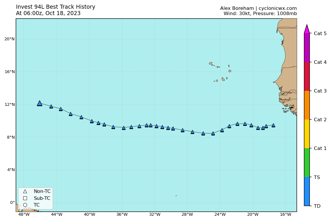
0 likes
- cycloneye
- Admin

- Posts: 149712
- Age: 69
- Joined: Thu Oct 10, 2002 10:54 am
- Location: San Juan, Puerto Rico
Re: ATL: INVEST 94L - Discussion
Tropical Weather Outlook
NWS National Hurricane Center Miami FL
800 AM EDT Wed Oct 18 2023
For the North Atlantic...Caribbean Sea and the Gulf of Mexico:
1. East of the Windward Islands (AL94):
Showers and thunderstorms associated with a broad area of low
pressure located about 850 miles east of the Windward Islands
continue to show signs of organization, however it is not yet clear
if the system has a well-defined surface circulation. Environmental
conditions are expected to remain conducive for additional
development, and a tropical depression is likely to form during the
next day or so while the system moves westward to west-northwestward
across the western tropical Atlantic toward the Lesser Antilles.
Interests in the Lesser Antilles should monitor the progress of this
system, and watches may be required for some of the islands later
today. Additional information, including storm warnings, can be
found in High Seas Forecasts issued by the National Weather Service.
Regardless of development, this system has the potential to bring
gusty winds, heavy rainfall, and flooding to portions of the Lesser
Antilles beginning Friday.
* Formation chance through 48 hours...high...80 percent.
* Formation chance through 7 days...high...80 percent.
High Seas Forecasts issued by the National Weather Service can be
found under AWIPS header NFDHSFAT1, WMO header FZNT01 KWBC, and
online at ocean.weather.gov/shtml/NFDHSFAT1.php
Forecaster Berg
1 likes
Visit the Caribbean-Central America Weather Thread where you can find at first post web cams,radars
and observations from Caribbean basin members Click Here
and observations from Caribbean basin members Click Here
- wxman57
- Moderator-Pro Met

- Posts: 23175
- Age: 68
- Joined: Sat Jun 21, 2003 8:06 pm
- Location: Houston, TX (southwest)
Re: ATL: INVEST 94L - Discussion
It seems that it's mainly the GFS that develops this wave. I don't doubt that it may develop enough of a circulation for the NHC to classify it. If it has a single squall, then it will be called a TS. That said, the faster it does develop, the earlier the northerly turn. If it remains a wave, it may move across the NE Caribbean, perhaps producing 3-6 inches of rain. A track clipping the NE Caribbean would likely keep TS wind east of the islands, as I don't expect much weather west of the center.
3 likes
Re: ATL: INVEST 94L - Discussion
Ianswfl wrote:abajan wrote:cycloneye wrote:Pressure down to 1008 mbs.AL, 94, 2023101800, , BEST, 0, 118N, 447W, 30, 1008, LO
https://i.imgur.com/ApTyrCm.png
Yes, and there's a slight bend in the track back towards the west too.
All interesting to watch down the road. 12z euro has it weak and bending back due west just north of Haiti with a strong high. Trof coming in at the end of teh run but who knows if that stalls or not over FL. GFS shows stronger ridging on the 18z run. But totally out to lunch on 94l. Pattern later in Oct favors warmer temps, stronger ridging in the southeast though. Something to watch.
BEST has this about 11.8N but looks more like 11.3 N to me as it really hasn't got a center yet.
Trough would dig and pick up anything stronger than a wave before Florida but the island forecast still looks a little unsure.
0 likes
Re: ATL: INVEST 94L - Discussion
The turn towards the west continues:
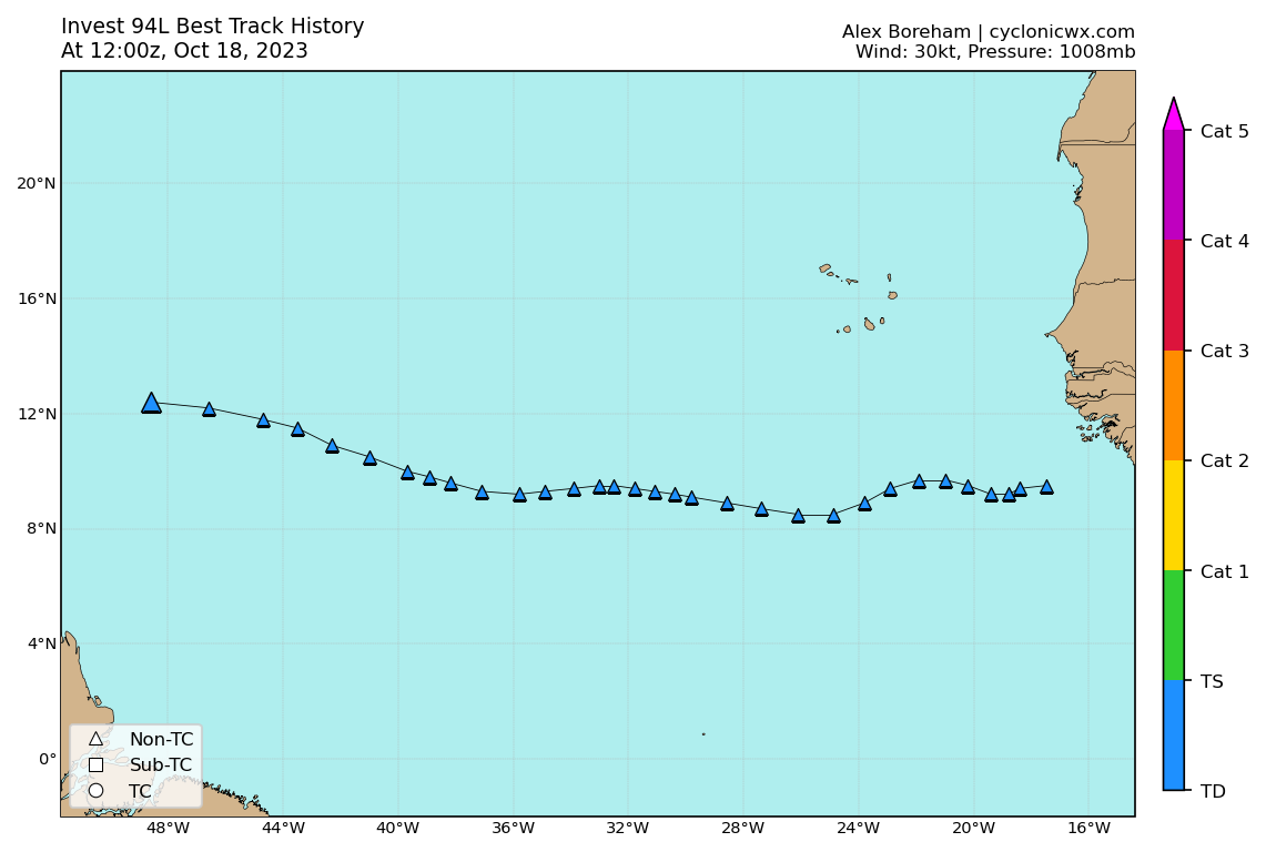
AL, 94, 2023101812, , BEST, 0, 124N, 486W, 30, 1008, LO

1 likes
- ScottNAtlanta
- Category 5

- Posts: 2535
- Joined: Sat May 25, 2013 3:11 pm
- Location: Atlanta, GA
Re: ATL: INVEST 94L - Discussion
Maybe it's just me, but this is looking just about as good as it ever has. For the first time I am seeing westerly inflow of the south side. I think this will develop within the nest day or two. I have also noticed the intensity models are on the upswing again. The models all seem to initialize this a bit too far north
1 likes
The posts in this forum are NOT official forecast and should not be used as such. They are just the opinion of the poster and may or may not be backed by sound meteorological data. They are NOT endorsed by any professional institution or storm2k.org. For official information, please refer to the NHC and NWS products.
Re: ATL: INVEST 94L - Discussion
ScottNAtlanta wrote:Maybe it's just me, but this is looking just about as good as it ever has. For the first time I am seeing westerly inflow of the south side. I think this will develop within the nest day or two. I have also noticed the intensity models are on the upswing again. The models all seem to initialize this a bit too far north
It's not just you Scott, I agree, as probably everyone does that 94L is looking healthy this morning, and to me, looks fairly low in latitude?...Xman 57s previous post seems most sensible to me as a bystander, but I can't help wonder, like you mention Scott, if 94Ls intensity will do as the modeks are hinting at?....like they say, bears watching...
1 likes
- cycloneye
- Admin

- Posts: 149712
- Age: 69
- Joined: Thu Oct 10, 2002 10:54 am
- Location: San Juan, Puerto Rico
Re: ATL: INVEST 94L - Discussion
Ummm, 12z Best Track updated up to 35kt and pressure down to 1007 mbs.

AL, 94, 2023101812, , BEST, 0, 124N, 486W, 35, 1007, LO

1 likes
Visit the Caribbean-Central America Weather Thread where you can find at first post web cams,radars
and observations from Caribbean basin members Click Here
and observations from Caribbean basin members Click Here
- Iceresistance
- Category 5

- Posts: 9606
- Age: 22
- Joined: Sat Oct 10, 2020 9:45 am
- Location: Tecumseh, OK/Norman, OK
Re: ATL: INVEST 94L - Discussion
5 likes
Bill 2015 & Beta 2020
Winter 2020-2021
All observations are in Tecumseh, OK unless otherwise noted.
Winter posts are focused mainly for Oklahoma & Texas.
Take any of my forecasts with a grain of salt, refer to the NWS, SPC, and NHC for official information
Never say Never with weather! Because ANYTHING is possible!
Winter 2020-2021

All observations are in Tecumseh, OK unless otherwise noted.
Winter posts are focused mainly for Oklahoma & Texas.
Take any of my forecasts with a grain of salt, refer to the NWS, SPC, and NHC for official information
Never say Never with weather! Because ANYTHING is possible!
-
Sciencerocks
- Category 5

- Posts: 10193
- Age: 40
- Joined: Thu Jul 06, 2017 1:51 am
Re: ATL: INVEST 94L - Discussion
Looks like a well defined LLC and I'd expect an upgrade at anytime. 


2 likes
- AubreyStorm
- Category 1

- Posts: 337
- Age: 45
- Joined: Fri Jun 16, 2017 6:21 pm
- Location: Texas, USA
Re: ATL: INVEST 94L - Discussion
By Dr. Levi Cowan
Invest #94L is becoming better organized, with the wave cusp now rolling into what may be a closed circulation, if a bit elongated. 94L could become a tropical storm at any time, and @NHC_Atlantic may issue Tropical Storm Watches soon for the Leeward Islands, as a west-northwestward track will take 94L close to the islands on Friday or Saturday.
Which islands experience heavy weather will depend on which side of 94L they fall on. Westerly wind shear is likely to keep the western/southern side of the circulation drier and less windy than the eastern/northern side. There is some spread in model forecasts for the exact track near the islands, so anyone between Puerto Rico and the Lesser Antilles has a chance to see Tropical Storm conditions. The track possibilities should narrow once a tropical storm forms.
1 likes
The posts are NOT an official forecast. Please REFER to the NHC and NWS for official forecasts and products.
- cycloneye
- Admin

- Posts: 149712
- Age: 69
- Joined: Thu Oct 10, 2002 10:54 am
- Location: San Juan, Puerto Rico
Re: ATL: INVEST 94L - Discussion
For Msbee, Patti, GustyWind, watches will be up later this afternoon.
Tropical Weather Outlook
NWS National Hurricane Center Miami FL
200 PM EDT Wed Oct 18 2023
For the North Atlantic...Caribbean Sea and the Gulf of Mexico:
1. East of the Windward Islands (AL94):
Recent visible satellite images indicate that the circulation
associated with an area of low pressure located about 700 miles
east of the Windward Islands is gradually becoming better defined.
In addition, the associated shower and thunderstorm activity is
becoming more organized, and satellite-derived wind data indicated
that the system is already producing winds to tropical storm force.
Continued development is anticipated, and a tropical storm is
expected to form later today or tonight while moving westward or
west-northwestward toward the Lesser Antilles.
Interests in the Lesser Antilles should continue to monitor the
progress of the disturbance. Advisories may be initiated on this
system as early as later this afternoon, and could include the
issuance of watches for some of the islands. Regardless of
development, this system has the potential to bring gusty winds,
heavy rainfall, and flash flooding to portions of the Lesser
Antilles beginning on Friday. Additional information, including
storm warnings, can be found in High Seas Forecasts issued by the
National Weather Service.
* Formation chance through 48 hours...high...90 percent.
* Formation chance through 7 days...high...90 percent.
High Seas Forecasts issued by the National Weather Service can be
found under AWIPS header NFDHSFAT1, WMO header FZNT01 KWBC, and
online at ocean.weather.gov/shtml/NFDHSFAT1.php
Forecaster Berg
5 likes
Visit the Caribbean-Central America Weather Thread where you can find at first post web cams,radars
and observations from Caribbean basin members Click Here
and observations from Caribbean basin members Click Here
-
floridasun
- Tropical Storm

- Posts: 245
- Joined: Tue Sep 14, 2021 3:59 pm
Re: ATL: INVEST 94L - Discussion
Sciencerocks wrote:https://imagizer.imageshack.com/img922/1686/jv2X4Y.gif
I am floored that this isn't being upgraded at 5pm. That is a well defined LLC and already producing tropical storm force winds.
Not 5pm nhc say iikely watch later today
0 likes
- DorkyMcDorkface
- Category 5

- Posts: 1043
- Age: 28
- Joined: Mon Sep 30, 2019 1:32 pm
- Location: Mid-Atlantic
Re: ATL: INVEST 94L - Discussion
floridasun wrote:Sciencerocks wrote:https://imagizer.imageshack.com/img922/1686/jv2X4Y.gif
I am floored that this isn't being upgraded at 5pm. That is a well defined LLC and already producing tropical storm force winds.
Not 5pm nhc say iikely watch later today
Looks like it will be 5:


2 likes
Please note the thoughts expressed by this account are solely those of the user and are from a hobbyist perspective. For more comprehensive analysis, consult an actual professional meteorologist or meteorological agency.
Floyd 1999 | Isabel 2003 | Hanna 2008 | Irene 2011 | Sandy 2012 | Isaias 2020
- DorkyMcDorkface
- Category 5

- Posts: 1043
- Age: 28
- Joined: Mon Sep 30, 2019 1:32 pm
- Location: Mid-Atlantic
Re: ATL: INVEST 94L - Discussion
6 likes
Please note the thoughts expressed by this account are solely those of the user and are from a hobbyist perspective. For more comprehensive analysis, consult an actual professional meteorologist or meteorological agency.
Floyd 1999 | Isabel 2003 | Hanna 2008 | Irene 2011 | Sandy 2012 | Isaias 2020
Re: ATL: TAMMY - Tropical Storm - Discussion
Wow, two named MDR storms in October during a strong El Niño. Even if Tammy ends up as a repeat of Sean, it’s still an impressive feat.
1 likes
Irene '11 Sandy '12 Hermine '16 5/15/2018 Derecho Fay '20 Isaias '20 Elsa '21 Henri '21 Ida '21
I am only a meteorology enthusiast who knows a decent amount about tropical cyclones. Look to the professional mets, the NHC, or your local weather office for the best information.
I am only a meteorology enthusiast who knows a decent amount about tropical cyclones. Look to the professional mets, the NHC, or your local weather office for the best information.
Who is online
Users browsing this forum: No registered users and 67 guests


