
ATL: TAMMY - Models
Moderator: S2k Moderators
-
tolakram
- Admin

- Posts: 20186
- Age: 62
- Joined: Sun Aug 27, 2006 8:23 pm
- Location: Florence, KY (name is Mark)
Re: ATL: TAMMY - Models
0 likes
M a r k
- - - - -
Join us in chat: Storm2K Chatroom Invite. Android and IOS apps also available.
The posts in this forum are NOT official forecasts and should not be used as such. Posts are NOT endorsed by any professional institution or STORM2K.org. For official information and forecasts, please refer to NHC and NWS products.
-
tolakram
- Admin
- Posts: 20186
- Age: 62
- Joined: Sun Aug 27, 2006 8:23 pm
- Location: Florence, KY (name is Mark)
Re: ATL: TAMMY - Models
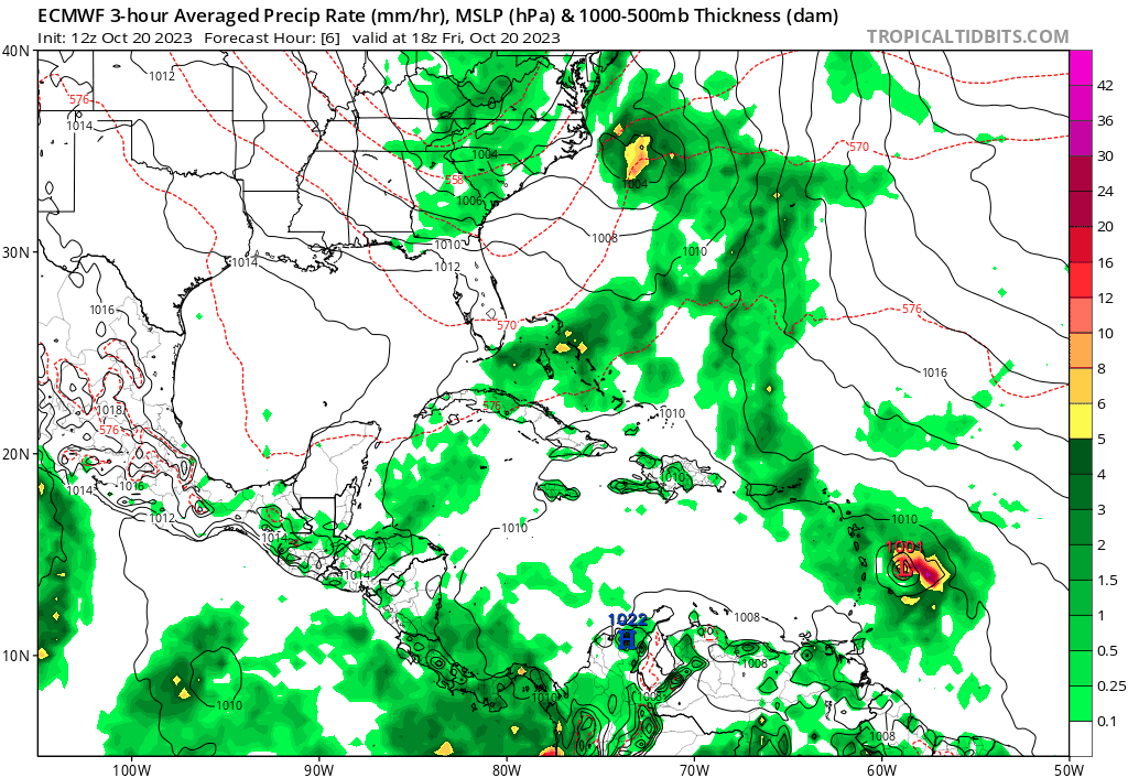
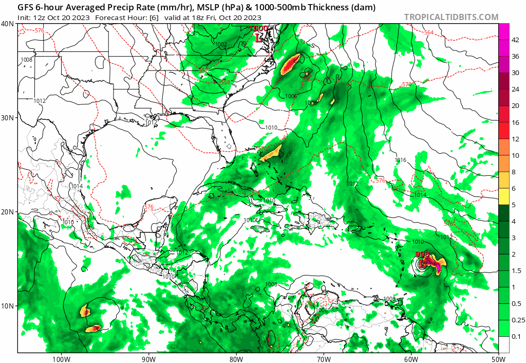
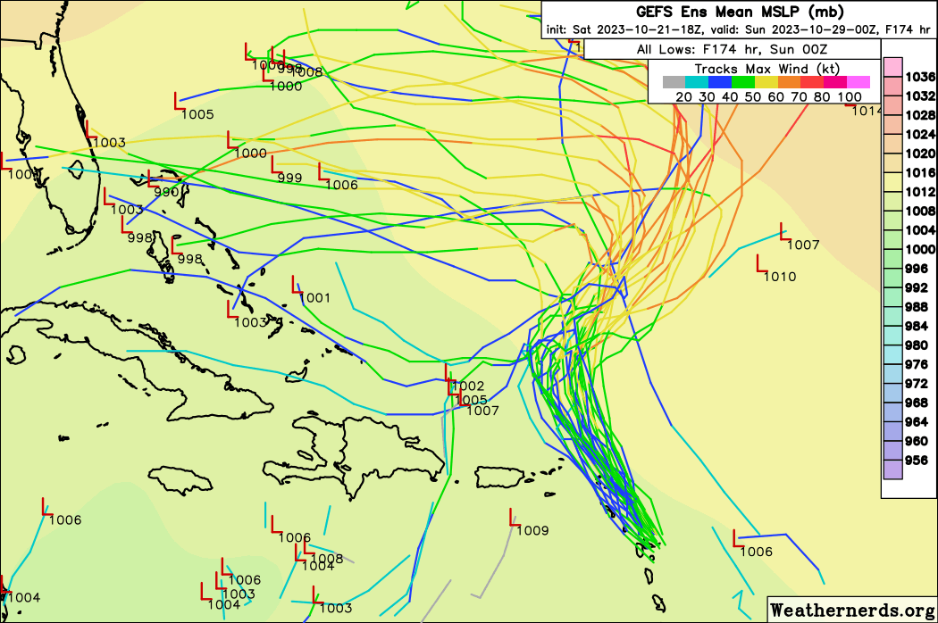
3 models, 3 different passes near the islands. GFS is rightmost, CMC left most.


0 likes
M a r k
- - - - -
Join us in chat: Storm2K Chatroom Invite. Android and IOS apps also available.
The posts in this forum are NOT official forecasts and should not be used as such. Posts are NOT endorsed by any professional institution or STORM2K.org. For official information and forecasts, please refer to NHC and NWS products.
- - - - -
Join us in chat: Storm2K Chatroom Invite. Android and IOS apps also available.
The posts in this forum are NOT official forecasts and should not be used as such. Posts are NOT endorsed by any professional institution or STORM2K.org. For official information and forecasts, please refer to NHC and NWS products.
-
tolakram
- Admin
- Posts: 20186
- Age: 62
- Joined: Sun Aug 27, 2006 8:23 pm
- Location: Florence, KY (name is Mark)
Re: ATL: TAMMY - Models
GFS continues to correct west.

0 likes
M a r k
- - - - -
Join us in chat: Storm2K Chatroom Invite. Android and IOS apps also available.
The posts in this forum are NOT official forecasts and should not be used as such. Posts are NOT endorsed by any professional institution or STORM2K.org. For official information and forecasts, please refer to NHC and NWS products.
- - - - -
Join us in chat: Storm2K Chatroom Invite. Android and IOS apps also available.
The posts in this forum are NOT official forecasts and should not be used as such. Posts are NOT endorsed by any professional institution or STORM2K.org. For official information and forecasts, please refer to NHC and NWS products.
-
ThunderForce

- Tropical Storm

- Posts: 208
- Age: 26
- Joined: Tue Sep 27, 2022 6:20 pm
- Location: Calhoun County, Florida
Re: ATL: TAMMY - Models
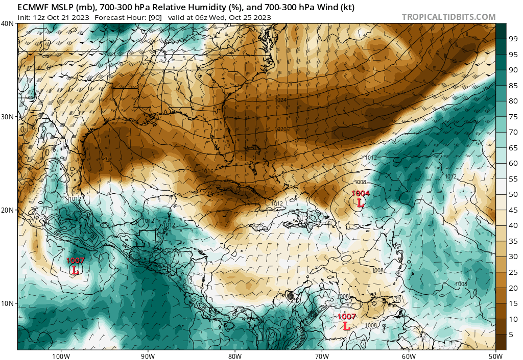
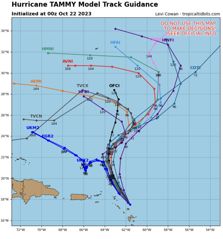
Well, this is... quite a difference. Tammy is now much slower in the Euro than the GFS and seems to stall after making it north of the islands, whereas it gets picked up by the trough and moves northeastward in the GFS. Euro is also a lot weaker in comparison to the GFS for the whole run, for some reason.
12z Euro:
12z GFS:
12z Euro:
12z GFS:
1 likes
Please refer to the NWS, NHC, SPC or a professional meteorologist for information and decision making during storms.
-
ElectricStorm

- Category 5

- Posts: 5157
- Age: 25
- Joined: Tue Aug 13, 2019 11:23 pm
- Location: Norman, OK
Re: ATL: TAMMY - Models
All 4 hurricane models for the 0z cycle are showing this making a run at Cat 3 north of the islands. Latest NHC disco doesn't really mention future intensity much outside of the next couple days but it'll be interesting to see if they start bumping it up it a bit soon.
0 likes
B.S Meteorology, University of Oklahoma '25
Please refer to the NHC, NWS, or SPC for official information.
Please refer to the NHC, NWS, or SPC for official information.
-
tolakram
- Admin
- Posts: 20186
- Age: 62
- Joined: Sun Aug 27, 2006 8:23 pm
- Location: Florence, KY (name is Mark)
Re: ATL: TAMMY - Models
ElectricStorm wrote:All 4 hurricane models for the 0z cycle are showing this making a run at Cat 3 north of the islands. Latest NHC disco doesn't really mention future intensity much outside of the next couple days but it'll be interesting to see if they start bumping it up it a bit soon.
The hurricane models are showing how bad it can be to be based off the GFS IF the GFS is horribly wrong. No real other option right now, but I hope they revisit the decision not to go a new direction with the GFS. If the GFS scores a rare win with the upper levels, and it did so over the last few days, then the models look awesome.
1 likes
M a r k
- - - - -
Join us in chat: Storm2K Chatroom Invite. Android and IOS apps also available.
The posts in this forum are NOT official forecasts and should not be used as such. Posts are NOT endorsed by any professional institution or STORM2K.org. For official information and forecasts, please refer to NHC and NWS products.
- - - - -
Join us in chat: Storm2K Chatroom Invite. Android and IOS apps also available.
The posts in this forum are NOT official forecasts and should not be used as such. Posts are NOT endorsed by any professional institution or STORM2K.org. For official information and forecasts, please refer to NHC and NWS products.
-
ScottNAtlanta

- Category 5
- Posts: 2535
- Joined: Sat May 25, 2013 3:11 pm
- Location: Atlanta, GA
Re: ATL: TAMMY - Models
Quite a few of the GFS members are taking this west now north of the islands. That's a very big change

0 likes
The posts in this forum are NOT official forecast and should not be used as such. They are just the opinion of the poster and may or may not be backed by sound meteorological data. They are NOT endorsed by any professional institution or storm2k.org. For official information, please refer to the NHC and NWS products.
-
DunedinDave
- Category 1

- Posts: 269
- Joined: Fri Aug 25, 2023 10:31 am
Re: ATL: TAMMY - Models
Almost seems like some models want to Jeanne with this and turn this thing around and west. Icon definitely on board with this solution albeit not as a strong system.
0 likes
-
Weathertracker96
- Tropical Storm
- Posts: 150
- Joined: Mon Oct 16, 2023 3:41 pm
Re: ATL: TAMMY - Models
Any thoughts on what Tammy could do post the islands? Looking the models, some still head NE while others trend west. The 12Z Euro looks interesting and I’m confused as to what it does with Tammy.
0 likes
-
ThunderForce
- Tropical Storm
- Posts: 208
- Age: 26
- Joined: Tue Sep 27, 2022 6:20 pm
- Location: Calhoun County, Florida
Re: ATL: TAMMY - Models
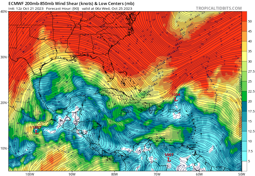
It seems the reason why Euro has Tammy weakening into a remnant low is due to both dry air and wind shear.
1 likes
Please refer to the NWS, NHC, SPC or a professional meteorologist for information and decision making during storms.
Re: ATL: TAMMY - Models
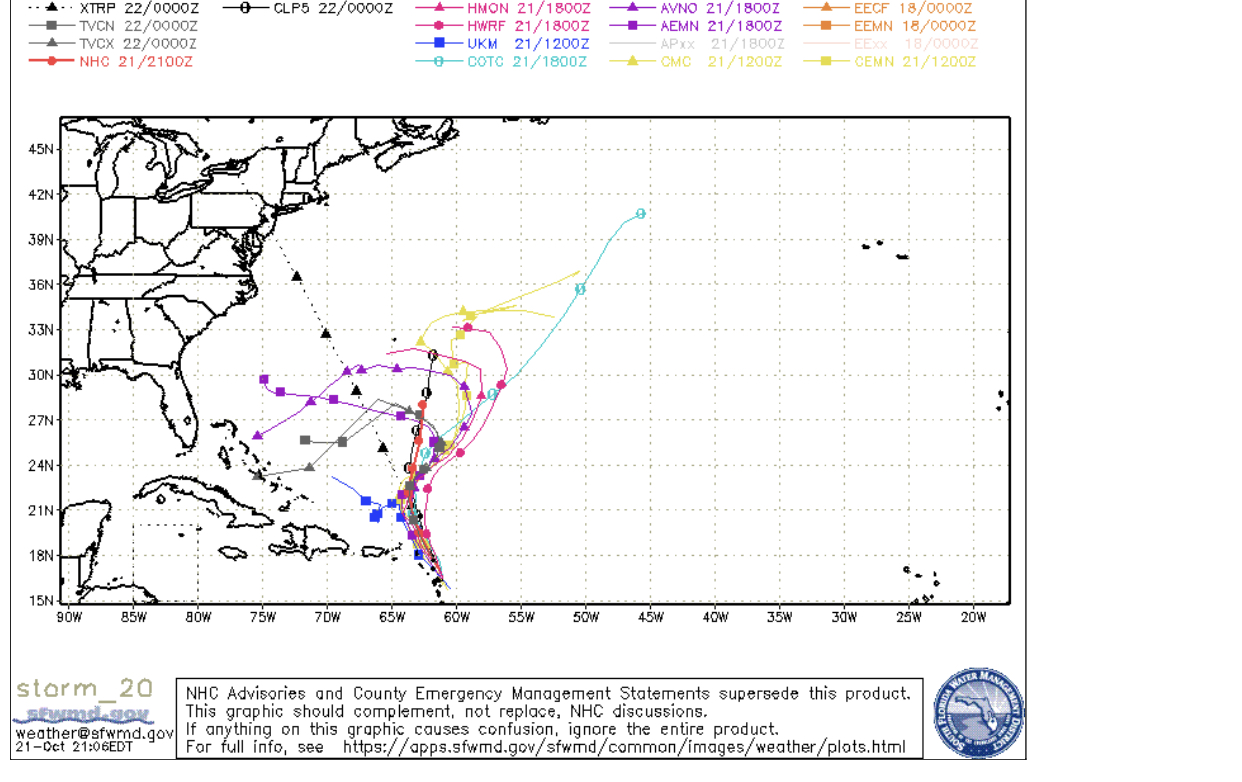
12Z UKMET turns it WNW starting hour 132 and continuing to end of run when it ends E of the Bahamas:
HURRICANE TAMMY ANALYSED POSITION : 15.8N 60.5W
ATCF IDENTIFIER : AL202023
LEAD CENTRAL MAXIMUM WIND
VERIFYING TIME TIME POSITION PRESSURE (MB) SPEED (KNOTS)
-------------- ---- -------- ------------- -------------
1200UTC 21.10.2023 0 15.8N 60.5W 993 59
0000UTC 22.10.2023 12 17.2N 61.9W 1003 43
1200UTC 22.10.2023 24 18.0N 62.9W 1005 36
0000UTC 23.10.2023 36 19.5N 63.8W 1004 39
1200UTC 23.10.2023 48 20.5N 64.3W 1005 39
0000UTC 24.10.2023 60 21.4N 64.4W 1005 33
1200UTC 24.10.2023 72 21.4N 65.0W 1005 29
0000UTC 25.10.2023 84 21.2N 65.7W 1005 28
1200UTC 25.10.2023 96 20.7N 66.1W 1004 29
0000UTC 26.10.2023 108 20.2N 66.1W 1003 30
1200UTC 26.10.2023 120 20.5N 66.3W 1002 31
0000UTC 27.10.2023 132 21.4N 65.9W 1001 37
1200UTC 27.10.2023 144 21.6N 67.0W 1001 35
0000UTC 28.10.2023 156 22.4N 68.0W 1002 30
1200UTC 28.10.2023 168 23.2N 69.6W 1004 31
Last edited by LarryWx on Sat Oct 21, 2023 8:37 pm, edited 1 time in total.
0 likes
Personal Forecast Disclaimer:
The posts in this forum are NOT official forecasts and should not be used as such. They are just the opinion of the poster and may or may not be backed by sound meteorological data. They are NOT endorsed by any professional institution or storm2k.org. For official information, please refer to the NHC and NWS products.
The posts in this forum are NOT official forecasts and should not be used as such. They are just the opinion of the poster and may or may not be backed by sound meteorological data. They are NOT endorsed by any professional institution or storm2k.org. For official information, please refer to the NHC and NWS products.
-
Blown Away

- S2K Supporter

- Posts: 10253
- Joined: Wed May 26, 2004 6:17 am
Re: ATL: TAMMY - Models
Getting Nicole vibes once Tammy clears the NE Caribbean.
1 likes
Hurricane Eye Experience: David 79, Irene 99, Frances 04, Jeanne 04, Wilma 05… Hurricane Brush Experience: Andrew 92, Erin 95, Floyd 99, Matthew 16, Irma 17, Ian 22, Nicole 22…
-
Blown Away
- S2K Supporter
- Posts: 10253
- Joined: Wed May 26, 2004 6:17 am
Re: ATL: TAMMY - Models
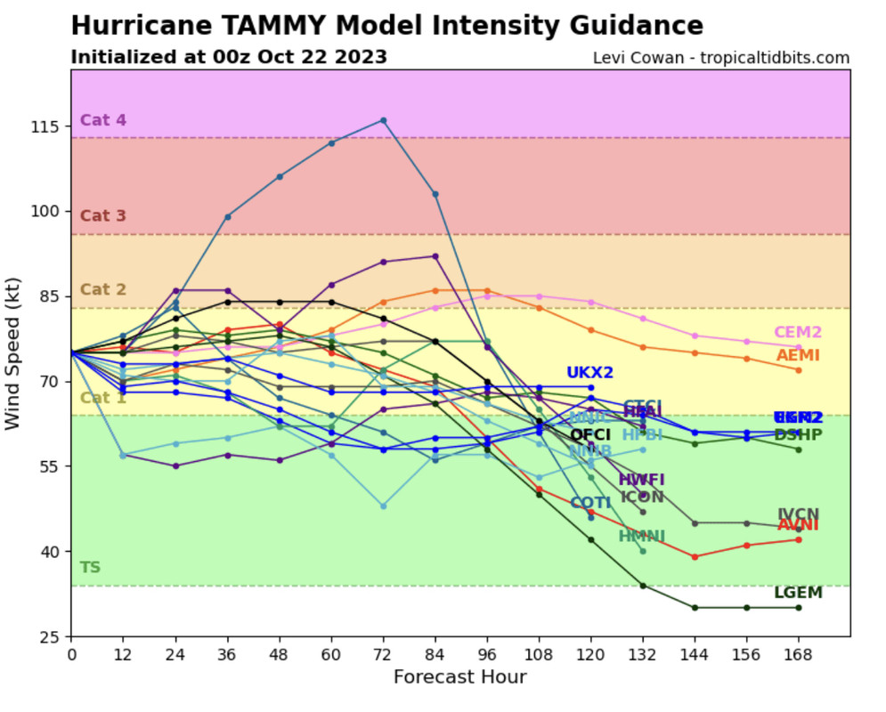
The earlier W turn models maintain strong TS/Cat1.
3 likes
Hurricane Eye Experience: David 79, Irene 99, Frances 04, Jeanne 04, Wilma 05… Hurricane Brush Experience: Andrew 92, Erin 95, Floyd 99, Matthew 16, Irma 17, Ian 22, Nicole 22…
-
SFLcane

- S2K Supporter
- Posts: 10281
- Age: 48
- Joined: Sat Jun 05, 2010 1:44 pm
- Location: Lake Worth Florida
Re: ATL: TAMMY - Models
Blown Away wrote:[url]https://i.postimg.cc/HLrtN89m/D1-BB96-D9-8-B8-A-4559-971-D-B45877419554.jpg [/url]
[url]https://i.postimg.cc/ZY8xXSpW/362-A0108-744-F-40-B1-AD96-2259646-D564-D.jpg [/url]
The earlier W turn models maintain strong TS/Cat1.

0 likes
-
Weathertracker96
- Tropical Storm
- Posts: 150
- Joined: Mon Oct 16, 2023 3:41 pm
Re: ATL: TAMMY - Models
Blown Away wrote:[url]https://i.postimg.cc/43s8FxFN/25233201-761-D-4-B00-9164-B087-A736957-E.jpg [/url]
Getting Nicole vibes once Tammy clears the NE Caribbean.
So basically high pressure is possibly building in pushing this possibly to the West? I know troughs have been the theme this year so I’m kinda surprised high pressure may come in especially in October.
I do remember Nicole from last year though.
0 likes
-
AutoPenalti
- Category 5
- Posts: 4091
- Age: 29
- Joined: Mon Aug 17, 2015 4:16 pm
- Location: Ft. Lauderdale, Florida
Re: ATL: TAMMY - Models
Excuse me??? lol
0 likes
The posts in this forum are NOT official forecasts and should not be used as such. They are just the opinion of the poster and may or may not be backed by sound meteorological data. They are NOT endorsed by any professional institution or STORM2K. For official information, please refer to products from the NHC and NWS.
Model Runs Cheat Sheet:
GFS (5:30 AM/PM, 11:30 AM/PM)
HWRF, GFDL, UKMET, NAVGEM (6:30-8:00 AM/PM, 12:30-2:00 AM/PM)
ECMWF (1:45 AM/PM)
TCVN is a weighted averaged
Who is online
Users browsing this forum: No registered users and 40 guests