ATL: TWENTY-ONE - Remnants - Discussion
Moderator: S2k Moderators
-
wxman57

- Moderator-Pro Met

- Posts: 23172
- Age: 68
- Joined: Sat Jun 21, 2003 8:06 pm
- Location: Houston, TX (southwest)
Re: ATL: INVEST 95L - Discussion
Consensus has it inland into Nicaragua late this evening. Final advisory would be by 4AM CDT tomorrow if the NHC starts them this afternoon. Are advisories really necessary?
0 likes
-
cycloneye

- Admin

- Posts: 149298
- Age: 69
- Joined: Thu Oct 10, 2002 10:54 am
- Location: San Juan, Puerto Rico
Re: ATL: INVEST 95L - Discussion
TD 21.
AL, 21, 2023102318, , BEST, 0, 114N, 833W, 25, 1007, TD, 34, NEQ, 0, 0, 0, 0, 1009, 100, 60, 0, 0, L, 0, , 0, 0, TWENTY-ONE, S, 0, , 0, 0, 0, 0, genesis-num, 041, TRANSITIONED, alD52023 to al212023,
1 likes
Visit the Caribbean-Central America Weather Thread where you can find at first post web cams,radars
and observations from Caribbean basin members Click Here
and observations from Caribbean basin members Click Here
-
Sciencerocks
- Category 5

- Posts: 10181
- Age: 40
- Joined: Thu Jul 06, 2017 1:51 am
-
Sciencerocks
- Category 5
- Posts: 10181
- Age: 40
- Joined: Thu Jul 06, 2017 1:51 am
-
MarioProtVI
- Category 5
- Posts: 1034
- Age: 24
- Joined: Sun Sep 29, 2019 7:33 pm
- Location: New Jersey
Re: ATL: TWENTY-ONE - Discussion
MarioProtVI wrote:Very disorganized at low levels. Don’t see this developing at all. It’s just about out of time and will move inland later tonight early tomorrow. Euro was correct in keeping this broad and weak and not developing it. Main threat will be mudslides and heavy rain.
This aged poorly.
1 likes
-
cycloneye
- Admin
- Posts: 149298
- Age: 69
- Joined: Thu Oct 10, 2002 10:54 am
- Location: San Juan, Puerto Rico
Re: ATL: TWENTY-ONE - Tropical Depression - Discussion
NHC will initiate advisories on Tropical Depression Twenty-One, located near the southern coast of Nicaragua, at 500 PM AST.
0 likes
Visit the Caribbean-Central America Weather Thread where you can find at first post web cams,radars
and observations from Caribbean basin members Click Here
and observations from Caribbean basin members Click Here

Re: ATL: INVEST 95L - Discussion
wxman57 wrote:Consensus has it inland into Nicaragua late this evening. Final advisory would be by 4AM CDT tomorrow if the NHC starts them this afternoon. Are advisories really necessary?
Yes, for the sake of accurate records.
5 likes
-
FrontRunner
- Tropical Depression

- Posts: 68
- Age: 42
- Joined: Wed Aug 23, 2006 9:01 pm
- Location: Westchester, NY
Re: ATL: INVEST 95L - Discussion
wxman57 wrote:Consensus has it inland into Nicaragua late this evening. Final advisory would be by 4AM CDT tomorrow if the NHC starts them this afternoon. Are advisories really necessary?
What's the downside to issuing advisories on a classifiable cyclone?
5 likes
-
cycloneye
- Admin
- Posts: 149298
- Age: 69
- Joined: Thu Oct 10, 2002 10:54 am
- Location: San Juan, Puerto Rico
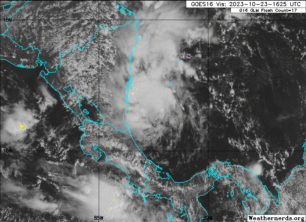
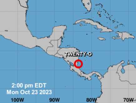
ATL: TWENTY-ONE - Advisories
Tropical Depression Twenty-One Discussion Number 1
NWS National Hurricane Center Miami FL AL212023
500 PM EDT Mon Oct 23 2023
The area of low pressure in the southwestern Caribbean Sea that the
NHC has been monitoring for the past few days has developed a
well-defined circulation. Convection is well-organized and has
persisted for over 12 hours, thus the disturbance is upgraded to
Tropical Depression Twenty-One. Scatterometer satellite data from a
few hours ago indicate that the intensity is around 25 kt. This is
also confirmed by the most recent Dvorak estimates provided by
TAFB and SAB.
The initial motion is estimated at an uncertain 280/4. The tropical
depression is on the western periphery of the upper level ridge,
which should keep it on a generally westward track over the next few
days. On this track, this system will be making landfall in southern
Nicaragua later this evening or tonight.
The tropical depression is in a favorable environment with low
wind shear values and warm sea-surface temperatures. However,
no strengthening is forecast since the depression is expected to
move inland soon. The depression will weaken quickly over Nicaragua
and dissipation is likely to occur tomorrow.
KEY MESSAGES:
1. Heavy rains from the depression will continue to impact portions
of Nicaragua through Tuesday night with heavy rainfall spreading
into Honduras during the day on Tuesday. This rainfall is likely to
produce flash and urban flooding, along with possible mudslides in
areas of higher terrain.
FORECAST POSITIONS AND MAX WINDS
INIT 23/2100Z 11.6N 83.5W 25 KT 30 MPH
12H 24/0600Z 12.0N 84.2W 20 KT 25 MPH...INLAND
24H 24/1800Z...DISSIPATED
$$
Forecaster Delgado/Cangialosi
0 likes
Visit the Caribbean-Central America Weather Thread where you can find at first post web cams,radars
and observations from Caribbean basin members Click Here
and observations from Caribbean basin members Click Here
-
Iceresistance

- Category 5
- Posts: 9579
- Age: 22
- Joined: Sat Oct 10, 2020 9:45 am
- Location: Tecumseh, OK/Norman, OK
Re: ATL: TWENTY-ONE - Tropical Depression - Discussion
3 likes
Bill 2015 & Beta 2020
Winter 2020-2021
All observations are in Tecumseh, OK unless otherwise noted.
Winter posts are focused mainly for Oklahoma & Texas.
Take any of my forecasts with a grain of salt, refer to the NWS, SPC, and NHC for official information
Never say Never with weather! Because ANYTHING is possible!
Winter 2020-2021
All observations are in Tecumseh, OK unless otherwise noted.
Winter posts are focused mainly for Oklahoma & Texas.
Take any of my forecasts with a grain of salt, refer to the NWS, SPC, and NHC for official information
Never say Never with weather! Because ANYTHING is possible!

Re: ATL: TWENTY-ONE - Tropical Depression - Discussion
The tropical depression is in a favorable environment with low
wind shear values and warm sea-surface temperatures. However,
no strengthening is forecast since the depression is expected to
move inland soon. The depression will weaken quickly over Nicaragua
and dissipation is likely to occur tomorrow.
wind shear values and warm sea-surface temperatures. However,
no strengthening is forecast since the depression is expected to
move inland soon. The depression will weaken quickly over Nicaragua
and dissipation is likely to occur tomorrow.
Poor TD21 whose only inhibitor is location (and steering currents pushing it inland). Probably would have been a lot stronger if only it had 24-48 more hours.
Low wind shear here is also atypical of an El Nino.
0 likes
TC naming lists: retirements and intensity
Most aggressive Advisory #1's in North Atlantic (cr. kevin for starting the list)
Most aggressive Advisory #1's in North Atlantic (cr. kevin for starting the list)

Re: ATL: TWENTY-ONE - Tropical Depression - Discussion
Breakfast might not be served at the best view hotel in Pearl Lagoon tomorrow.
Good roof though I think it will handle the wind.

Good roof though I think it will handle the wind.
0 likes
-
Sciencerocks
- Category 5
- Posts: 10181
- Age: 40
- Joined: Thu Jul 06, 2017 1:51 am
-
WalterWhite

- Category 1

- Posts: 342
- Joined: Fri Mar 17, 2023 5:53 pm
Re: ATL: TWENTY-ONE - Tropical Depression - Discussion
Before 21L, every single depression attained tropical storm strength at the minimum. It seems possible that Tropical Depression 21L will be break this trend.
1 likes
-
Sciencerocks
- Category 5
- Posts: 10181
- Age: 40
- Joined: Thu Jul 06, 2017 1:51 am
Re: ATL: TWENTY-ONE - Tropical Depression - Discussion
A lot of the models and intensity models suggest that this will become a 45-60 knot tropical storm in the eastern pacific. ;0)
0 likes
-
HurricaneBelle

- S2K Supporter

- Posts: 1209
- Joined: Sun Aug 27, 2006 6:12 pm
- Location: Clearwater, FL
Re: ATL: INVEST 95L - Discussion
wxman57 wrote:Consensus has it inland into Nicaragua late this evening. Final advisory would be by 4AM CDT tomorrow if the NHC starts them this afternoon. Are advisories really necessary?
You could say the NHC has doubled down on 21
0 likes
-
cycloneye
- Admin
- Posts: 149298
- Age: 69
- Joined: Thu Oct 10, 2002 10:54 am
- Location: San Juan, Puerto Rico
Re: ATL: TWENTY-ONE - Tropical Depression - Discussion
Sciencerocks wrote:A lot of the models and intensity models suggest that this will become a 45-60 knot tropical storm in the eastern pacific. ;0)
NHC already added it to EPAC TWO.
0 likes
Visit the Caribbean-Central America Weather Thread where you can find at first post web cams,radars
and observations from Caribbean basin members Click Here
and observations from Caribbean basin members Click Here
-
Sciencerocks
- Category 5
- Posts: 10181
- Age: 40
- Joined: Thu Jul 06, 2017 1:51 am
-
cycloneye
- Admin
- Posts: 149298
- Age: 69
- Joined: Thu Oct 10, 2002 10:54 am
- Location: San Juan, Puerto Rico
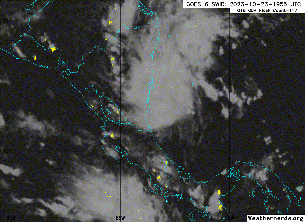
Re: ATL: TWENTY-ONE - Advisories
Tropical Depression Twenty-One Discussion Number 2
NWS National Hurricane Center Miami FL AL212023
1100 PM EDT Mon Oct 23 2023
It has been a challenge to find the center of the depression this
evening. Surface observations from Bluefields Airport in Nicaragua
indicated that the center of the depression likely moved northeast
of the observing station earlier this evening, but pressures in the
area were not particularly low. Since then, a robust mid-level
circulation has been visible in shortwave-infrared imagery, but it
isn't clear if this extends to the surface. ASCAT data is expected
within the next couple of hours, which should provide clarity over
whether the center of the depression has reformed under the
mid-level circulation, or if has already moved inland. TAFB and SAB
Dvorak estimates still support an intensity near 25 kt.
Once inland, the depression should quickly weaken and dissipate.
However, its worth noting that if the center is still over water
and remains there for any period of time overnight, some slight
strengthening could occur since the environment is otherwise
favorable for intensification. The long-term estimated motion is
around 310/4 kt, but this is highly uncertain. The depression, or
its remnants, are forecast to continue northwestward tonight, and
then generally head westward toward the eastern Pacific after that.
KEY MESSAGES:
1. Heavy rains from the depression will continue to impact portions
of Nicaragua through Tuesday night with heavy rainfall spreading
into Honduras during the day on Tuesday. This rainfall is likely to
produce flash and urban flooding, along with possible mudslides in
areas of higher terrain.
FORECAST POSITIONS AND MAX WINDS
INIT 24/0300Z 12.4N 83.4W 25 KT 30 MPH
12H 24/1200Z 13.1N 84.2W 25 KT 30 MPH...POST-TROP/REMNT LOW
24H 25/0000Z...DISSIPATED
$$
Forecaster D. Zelinsky
0 likes
Visit the Caribbean-Central America Weather Thread where you can find at first post web cams,radars
and observations from Caribbean basin members Click Here
and observations from Caribbean basin members Click Here
-
cycloneye
- Admin
- Posts: 149298
- Age: 69
- Joined: Thu Oct 10, 2002 10:54 am
- Location: San Juan, Puerto Rico
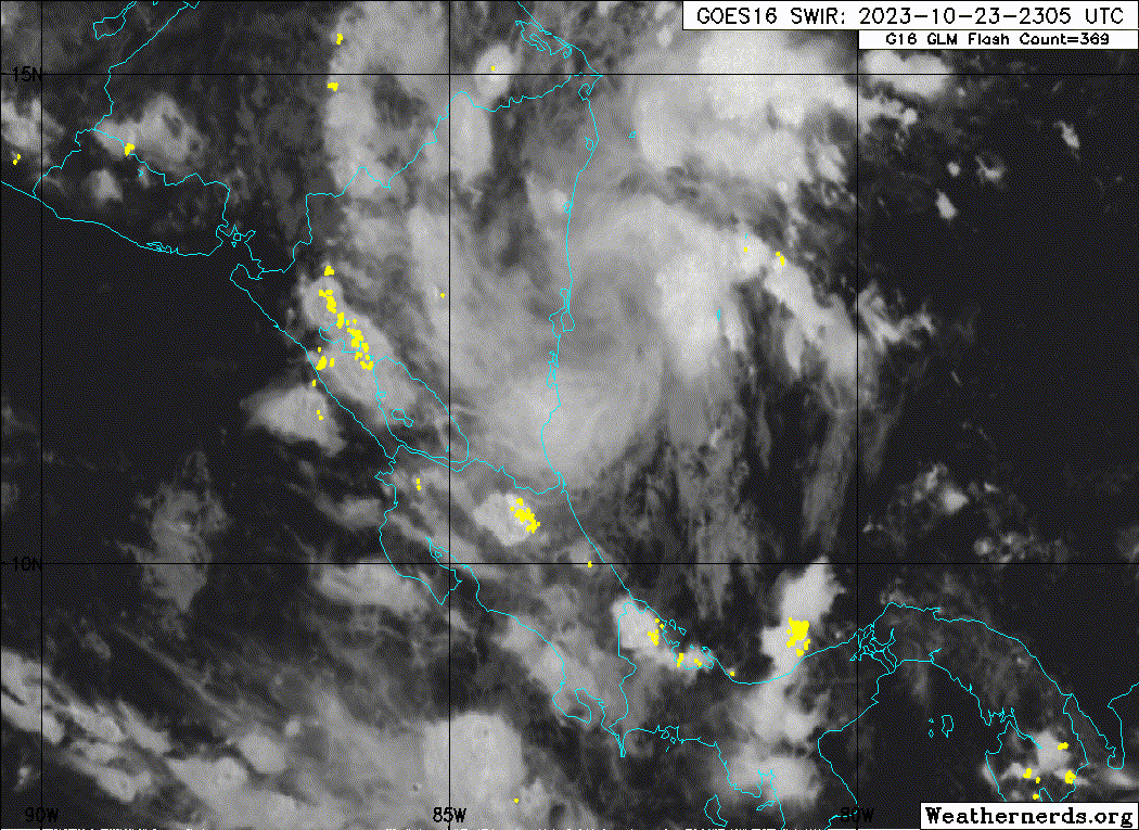
Re: ATL: TWENTY-ONE - Tropical Depression - Discussion
TTAA00 KNHC DDHHMM
Tropical Depression Twenty-One Discussion Number 3
NWS National Hurricane Center Miami FL AL212023
500 AM EDT Tue Oct 24 2023
Proxy-vis satellite imagery indicates that the center of Tropical
Depression Twenty-One has moved inland over Nicaragua tonight. This
was confirmed from both ASCAT B and -C scatterometer passes that
depicted there was no circulation offshore. Infrared imagery
indicates that deep convection remains just offshore. The initial
intensity is held at 25 kt for this advisory.
Since the center of the circulation has moved inland, the depression
should become a remnant low or dissipate later today. Heavy
rainfall with flash and urban flooding remain the primary impacts
even as the system dissipates. The estimated motion is around 310/5
kt. The depression and then the remnants, are forecast to continue
northwestward, and then generally head westward toward the eastern
Pacific after that.
KEY MESSAGES:
1. Heavy rains from the depression will continue to impact portions
of Nicaragua through Tuesday night with heavy rainfall spreading
into Honduras during the day on Tuesday. This rainfall is likely to
produce flash and urban flooding, along with possible mudslides in
areas of higher terrain.
FORECAST POSITIONS AND MAX WINDS
INIT 24/0900Z 13.1N 84.0W 25 KT 30 MPH
12H 24/1800Z 13.2N 84.8W 25 KT 30 MPH...POST-TROP/REMNT LOW
24H 25/0600Z...DISSIPATED
$$
Forecaster Kelly
0 likes
Visit the Caribbean-Central America Weather Thread where you can find at first post web cams,radars
and observations from Caribbean basin members Click Here
and observations from Caribbean basin members Click Here
Who is online
Users browsing this forum: No registered users and 51 guests