Since 1951, that area has not had a landfall.
https://twitter.com/pppapin/status/1716994016678392164
EPAC: OTIS - Aftermath - Discussion
Moderator: S2k Moderators
-
cycloneye

- Admin

- Posts: 149720
- Age: 69
- Joined: Thu Oct 10, 2002 10:54 am
- Location: San Juan, Puerto Rico
Re: EPAC: OTIS - Hurricane - Discussion
2 likes
Visit the Caribbean-Central America Weather Thread where you can find at first post web cams,radars
and observations from Caribbean basin members Click Here
and observations from Caribbean basin members Click Here
-
Yellow Evan

- Professional-Met

- Posts: 16257
- Age: 27
- Joined: Fri Jul 15, 2011 12:48 pm
- Location: Henderson, Nevada/Honolulu, HI
- Contact:
Re: EPAC: OTIS - Hurricane - Discussion
Only SAB uses CDG embedded anyway. It’s not an original part of Dvorak (1984).
1 likes

Re: EPAC: OTIS - Hurricane - Discussion
Eye is quickly clearing out even on 1-min imagery. So much for the hopes of shear - this is not like Eta which never really managed to clear out its eye as much as Raw #.
2 likes
TC naming lists: retirements and intensity
Most aggressive Advisory #1's in North Atlantic (cr. kevin for starting the list)
Most aggressive Advisory #1's in North Atlantic (cr. kevin for starting the list)
-
CrazyC83
- Professional-Met
- Posts: 34316
- Joined: Tue Mar 07, 2006 11:57 pm
- Location: Deep South, for the first time!
Re: EPAC: OTIS - Hurricane - Discussion
As for the advisory, the question is how high to place the intensity.
Based on the recent trends and analysis, I'd trust the Raw T# and go with 140 kt at the 10 pm advisory (pressure 927 mb). With landfall right around 12Z, I'd put a forecast intensity of 155 kt there, saying "On Coast", with a track shifted east to almost directly over Acapulco.
Based on the recent trends and analysis, I'd trust the Raw T# and go with 140 kt at the 10 pm advisory (pressure 927 mb). With landfall right around 12Z, I'd put a forecast intensity of 155 kt there, saying "On Coast", with a track shifted east to almost directly over Acapulco.
Last edited by CrazyC83 on Tue Oct 24, 2023 9:20 pm, edited 1 time in total.
5 likes


Re: EPAC: OTIS - Hurricane - Discussion
Scary. Wishing the best for everyone.
0 likes
Too many hurricanes to remember
-
Hurricane2022

- Category 5

- Posts: 2092
- Joined: Tue Aug 23, 2022 11:38 pm
- Location: Araçatuba, Brazil
Re: EPAC: OTIS - Hurricane - Discussion
I think that NHC will go with 135 kt for the 03z advisory, and 140 - 145 kt at 06z intermediate advisory, if Otis continues his ERI.
0 likes
Sorry for the bad English sometimes...!
For reliable and detailed information for any meteorological phenomenon, please consult the National Hurricane Center, Joint Typhoon Warning Center , or your local Meteo Center.
--------
ECCE OMNIA NOVA FACIAM (Ap 21,5).
For reliable and detailed information for any meteorological phenomenon, please consult the National Hurricane Center, Joint Typhoon Warning Center , or your local Meteo Center.
--------
ECCE OMNIA NOVA FACIAM (Ap 21,5).
-
Hurricane2022
- Category 5
- Posts: 2092
- Joined: Tue Aug 23, 2022 11:38 pm
- Location: Araçatuba, Brazil
Re: EPAC: OTIS - Hurricane - Discussion
Ok folks...many of us know that hope is just a water gun in a situation like this...Unless the people of Acapulco get informed and try to organize themselves quickly...I think that only a miracle from divine forces can prevent a major disaster here, unfortunately...
Last edited by Hurricane2022 on Tue Oct 24, 2023 9:39 pm, edited 1 time in total.
2 likes
Sorry for the bad English sometimes...!
For reliable and detailed information for any meteorological phenomenon, please consult the National Hurricane Center, Joint Typhoon Warning Center , or your local Meteo Center.
--------
ECCE OMNIA NOVA FACIAM (Ap 21,5).
For reliable and detailed information for any meteorological phenomenon, please consult the National Hurricane Center, Joint Typhoon Warning Center , or your local Meteo Center.
--------
ECCE OMNIA NOVA FACIAM (Ap 21,5).
-
CrazyC83
- Professional-Met
- Posts: 34316
- Joined: Tue Mar 07, 2006 11:57 pm
- Location: Deep South, for the first time!
Re: EPAC: OTIS - Hurricane - Discussion: 4 PM CDT=125 mph (CAT 4)
KirbyDude25 wrote:Hurricane2022 wrote::lol:
https://imageshack.com/i/poqEJovkj
That's definitely getting changed in the TCR post-season, but for now, it definitely shows just how rapid Otis's intensification has been. Even after it's smoothed out to account for inaccuracies in pre-recon estimates, it still likely strengthened about 65 knots in 24 hours.
My guess for the BT intensities for the last 24 hours:
24/0000 - 45 kt, 1005 mb
24/0600 - 55 kt, 1000 mb
24/1200 - 70 kt, 991 mb
24/1800 - 100 kt, 971 mb
25/0000 - 130 kt, 940 mb
That's still an 85 kt increase in 24 hours if that is how it is set, even though hurricane status is a little earlier.
1 likes
-
Astromanía
- Category 2

- Posts: 798
- Age: 27
- Joined: Sat Aug 25, 2018 10:34 pm
- Location: Monterrey, N.L, México
Re: EPAC: OTIS - Hurricane - Discussion
He is getting closer and closer to Acapulco, pray for my fellows there please
1 likes
-
KirbyDude25

- Tropical Storm

- Posts: 162
- Age: 21
- Joined: Mon Sep 20, 2021 8:03 am
- Location: Westfield, New Jersey
Re: EPAC: OTIS - Hurricane - Discussion: 4 PM CDT=125 mph (CAT 4)
CrazyC83 wrote:KirbyDude25 wrote:Hurricane2022 wrote::lol:
https://imageshack.com/i/poqEJovkj
That's definitely getting changed in the TCR post-season, but for now, it definitely shows just how rapid Otis's intensification has been. Even after it's smoothed out to account for inaccuracies in pre-recon estimates, it still likely strengthened about 65 knots in 24 hours.
My guess for the BT intensities for the last 24 hours:
24/0000 - 45 kt, 1005 mb
24/0600 - 55 kt, 1000 mb
24/1200 - 70 kt, 991 mb
24/1800 - 100 kt, 971 mb
25/0000 - 130 kt, 940 mb
That's still an 85 kt increase in 24 hours if that is how it is set, even though hurricane status is a little earlier.
Considering that it's been 5 hours since I posted that when the 5 PM EDT advisory pegged this at 110 knots, your estimate is likely accurate given Otis's continued RI
0 likes
New Jersey, Rutgers '27
Irene 2011 | Sandy 2012 | Fay 2020 | Isaias 2020 | Ida 2021
Irene 2011 | Sandy 2012 | Fay 2020 | Isaias 2020 | Ida 2021
Re: EPAC: OTIS - Hurricane - Discussion
Cat 5.
WTPZ23 KNHC 250247
TCMEP3
HURRICANE OTIS FORECAST/ADVISORY NUMBER 12
NWS NATIONAL HURRICANE CENTER MIAMI FL EP182023
0300 UTC WED OCT 25 2023
NOTICE... LAND-BASED TROPICAL CYCLONE WATCHES AND WARNINGS ARE NO
LONGER INCLUDED IN THE TROPICAL CYCLONE FORECAST/ADVISORY...(TCM).
CURRENT LAND-BASED COASTAL WATCHES AND WARNINGS CAN BE FOUND IN THE
MOST RECENTLY ISSUED TROPICAL CYCLONE PUBLIC ADVISORY...(TCP).
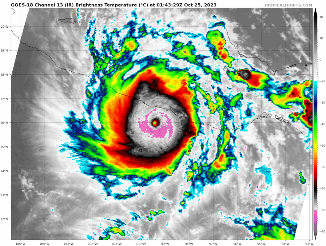
HURRICANE CENTER LOCATED NEAR 16.1N 99.7W AT 25/0300Z
POSITION ACCURATE WITHIN 20 NM
PRESENT MOVEMENT TOWARD THE NORTH-NORTHWEST OR 345 DEGREES AT 8 KT
ESTIMATED MINIMUM CENTRAL PRESSURE 927 MB
EYE DIAMETER 15 NM
MAX SUSTAINED WINDS 140 KT WITH GUSTS TO 170 KT.
64 KT....... 25NE 20SE 20SW 20NW.
50 KT....... 40NE 30SE 30SW 30NW.
34 KT....... 60NE 50SE 40SW 60NW.
12 FT SEAS.. 75NE 60SE 60SW 75NW.
WINDS AND SEAS VARY GREATLY IN EACH QUADRANT. RADII IN NAUTICAL
MILES ARE THE LARGEST RADII EXPECTED ANYWHERE IN THAT QUADRANT.
TCMEP3
HURRICANE OTIS FORECAST/ADVISORY NUMBER 12
NWS NATIONAL HURRICANE CENTER MIAMI FL EP182023
0300 UTC WED OCT 25 2023
NOTICE... LAND-BASED TROPICAL CYCLONE WATCHES AND WARNINGS ARE NO
LONGER INCLUDED IN THE TROPICAL CYCLONE FORECAST/ADVISORY...(TCM).
CURRENT LAND-BASED COASTAL WATCHES AND WARNINGS CAN BE FOUND IN THE
MOST RECENTLY ISSUED TROPICAL CYCLONE PUBLIC ADVISORY...(TCP).
HURRICANE CENTER LOCATED NEAR 16.1N 99.7W AT 25/0300Z
POSITION ACCURATE WITHIN 20 NM
PRESENT MOVEMENT TOWARD THE NORTH-NORTHWEST OR 345 DEGREES AT 8 KT
ESTIMATED MINIMUM CENTRAL PRESSURE 927 MB
EYE DIAMETER 15 NM
MAX SUSTAINED WINDS 140 KT WITH GUSTS TO 170 KT.
64 KT....... 25NE 20SE 20SW 20NW.
50 KT....... 40NE 30SE 30SW 30NW.
34 KT....... 60NE 50SE 40SW 60NW.
12 FT SEAS.. 75NE 60SE 60SW 75NW.
WINDS AND SEAS VARY GREATLY IN EACH QUADRANT. RADII IN NAUTICAL
MILES ARE THE LARGEST RADII EXPECTED ANYWHERE IN THAT QUADRANT.
5 likes
-
Iceresistance

- Category 5
- Posts: 9607
- Age: 22
- Joined: Sat Oct 10, 2020 9:45 am
- Location: Tecumseh, OK/Norman, OK
Re: EPAC: OTIS - Hurricane - Discussion
They actually did it! Otis is a Category 5! 
...OTIS RAPIDLY INTENSIFIES TO A CATEGORY 5 HURRICANE... ...CATASTROPHIC DAMAGE LIKELY WHERE THE CORE OF THE HURRICANE MOVES ONSHORE...
10:00 PM CDT Tue Oct 24
Location: 16.1°N 99.7°W
Moving: NNW at 9 mph
Min pressure: 927 mb
Max sustained: 160 mph
10:00 PM CDT Tue Oct 24
Location: 16.1°N 99.7°W
Moving: NNW at 9 mph
Min pressure: 927 mb
Max sustained: 160 mph
5 likes
Bill 2015 & Beta 2020
Winter 2020-2021
All observations are in Tecumseh, OK unless otherwise noted.
Winter posts are focused mainly for Oklahoma & Texas.
Take any of my forecasts with a grain of salt, refer to the NWS, SPC, and NHC for official information
Never say Never with weather! Because ANYTHING is possible!
Winter 2020-2021
All observations are in Tecumseh, OK unless otherwise noted.
Winter posts are focused mainly for Oklahoma & Texas.
Take any of my forecasts with a grain of salt, refer to the NWS, SPC, and NHC for official information
Never say Never with weather! Because ANYTHING is possible!
-
cycloneye
- Admin
- Posts: 149720
- Age: 69
- Joined: Thu Oct 10, 2002 10:54 am
- Location: San Juan, Puerto Rico
Re: EPAC: OTIS - Hurricane - Discussion: 10 PM CDT Advisory=140kt / Cat 5
BULLETIN
Hurricane Otis Advisory Number 12
NWS National Hurricane Center Miami FL EP182023
1000 PM CDT Tue Oct 24 2023
...OTIS RAPIDLY INTENSIFIES TO A CATEGORY 5 HURRICANE...
...CATASTROPHIC DAMAGE LIKELY WHERE THE CORE OF THE HURRICANE MOVES
ONSHORE...
SUMMARY OF 1000 PM CDT...0300 UTC...INFORMATION
-----------------------------------------------
LOCATION...16.1N 99.7W
ABOUT 55 MI...90 KM SSE OF ACAPULCO MEXICO
MAXIMUM SUSTAINED WINDS...160 MPH...260 KM/H
PRESENT MOVEMENT...NNW OR 345 DEGREES AT 9 MPH...15 KM/H
MINIMUM CENTRAL PRESSURE...927 MB...27.38 INCHES
Hurricane Otis Discussion Number 12
NWS National Hurricane Center Miami FL EP182023
1000 PM CDT Tue Oct 24 2023
A nightmare scenario is unfolding for southern Mexico this evening
with rapidly intensifying Otis approaching the coastline. Satellite
images show that Otis has continued to intensify, with Dvorak
Data-T estimates between 130-145 kt during the past few hours. The
initial wind speed is set to 140 kt as a blend of these values,
making Otis a Category 5 hurricane. Otis has explosively
intensified 95 kt during the past 24 hours, a mark only exceeded in
modern times by Patricia in 2015.
Otis should maintain category 5 status before the hurricane makes
landfall near the Acapulco area overnight or early on Wednesday.
The only significant change to mention to the track forecast is
that it has been shifted to the right due to a recent wobble to the
east and the latest model trends, and a general north-northwest
motion at about 8 kt is anticipated through landfall. Rapid
weakening is anticipated after landfall, and Otis should dissipate
tomorrow night over the higher terrain of Mexico.
This is an extremely serious situation for the Acapulco
metropolitan area with the core of the destructive hurricane likely
to come near or over that large city early on Wednesday. There are
no hurricanes on record even close to this intensity for this part
of Mexico.
Key Messages:
1. Otis is forecast to be a potentially catastrophic Category 5
hurricane when it reaches the southern coast of Mexico early
Wednesday. Life-threatening hurricane-force winds are expected in
portions of the Hurricane Warning area with catastrophic damage
expected.
2. A potentially catastrophic storm surge is expected to produce
life-threatening coastal flooding near and to the east of where the
center makes landfall. Near the coast, the surge will be
accompanied by large and destructive waves.
3. Heavy rains from Otis will continue to impact areas of southwest
Mexico this week. This rainfall will produce flash and urban
flooding, along with mudslides in areas of higher terrain.
FORECAST POSITIONS AND MAX WINDS
INIT 25/0300Z 16.1N 99.7W 140 KT 160 MPH
12H 25/1200Z 17.3N 100.1W 105 KT 120 MPH...INLAND
24H 26/0000Z 18.0N 100.5W 45 KT 50 MPH...INLAND
36H 26/1200Z...DISSIPATED
$$
Forecaster Blake
5 likes
Visit the Caribbean-Central America Weather Thread where you can find at first post web cams,radars
and observations from Caribbean basin members Click Here
and observations from Caribbean basin members Click Here
-
Astromanía
- Category 2
- Posts: 798
- Age: 27
- Joined: Sat Aug 25, 2018 10:34 pm
- Location: Monterrey, N.L, México
Re: EPAC: OTIS - Hurricane - Discussion: 10 PM CDT Advisory=140kt / Cat 5
0 likes
-
Iceresistance
- Category 5
- Posts: 9607
- Age: 22
- Joined: Sat Oct 10, 2020 9:45 am
- Location: Tecumseh, OK/Norman, OK
Re: EPAC: OTIS - Hurricane - Discussion: 10 PM CDT Advisory=140kt / Cat 5
cycloneye wrote:BULLETIN
Hurricane Otis Advisory Number 12
NWS National Hurricane Center Miami FL EP182023
1000 PM CDT Tue Oct 24 2023
...OTIS RAPIDLY INTENSIFIES TO A CATEGORY 5 HURRICANE...
...CATASTROPHIC DAMAGE LIKELY WHERE THE CORE OF THE HURRICANE MOVES
ONSHORE...
SUMMARY OF 1000 PM CDT...0300 UTC...INFORMATION
-----------------------------------------------
LOCATION...16.1N 99.7W
ABOUT 55 MI...90 KM SSE OF ACAPULCO MEXICO
MAXIMUM SUSTAINED WINDS...160 MPH...260 KM/H
PRESENT MOVEMENT...NNW OR 345 DEGREES AT 9 MPH...15 KM/H
MINIMUM CENTRAL PRESSURE...927 MB...27.38 INCHES
Hurricane Otis Discussion Number 12
NWS National Hurricane Center Miami FL EP182023
1000 PM CDT Tue Oct 24 2023
A nightmare scenario is unfolding for southern Mexico this evening
with rapidly intensifying Otis approaching the coastline. Satellite
images show that Otis has continued to intensify, with Dvorak
Data-T estimates between 130-145 kt during the past few hours. The
initial wind speed is set to 140 kt as a blend of these values,
making Otis a Category 5 hurricane. Otis has explosively
intensified 95 kt during the past 24 hours, a mark only exceeded in
modern times by Patricia in 2015.
Otis should maintain category 5 status before the hurricane makes
landfall near the Acapulco area overnight or early on Wednesday.
The only significant change to mention to the track forecast is
that it has been shifted to the right due to a recent wobble to the
east and the latest model trends, and a general north-northwest
motion at about 8 kt is anticipated through landfall. Rapid
weakening is anticipated after landfall, and Otis should dissipate
tomorrow night over the higher terrain of Mexico.
This is an extremely serious situation for the Acapulco
metropolitan area with the core of the destructive hurricane likely
to come near or over that large city early on Wednesday. There are
no hurricanes on record even close to this intensity for this part
of Mexico.
Key Messages:
1. Otis is forecast to be a potentially catastrophic Category 5
hurricane when it reaches the southern coast of Mexico early
Wednesday. Life-threatening hurricane-force winds are expected in
portions of the Hurricane Warning area with catastrophic damage
expected.
2. A potentially catastrophic storm surge is expected to produce
life-threatening coastal flooding near and to the east of where the
center makes landfall. Near the coast, the surge will be
accompanied by large and destructive waves.
3. Heavy rains from Otis will continue to impact areas of southwest
Mexico this week. This rainfall will produce flash and urban
flooding, along with mudslides in areas of higher terrain.
FORECAST POSITIONS AND MAX WINDS
INIT 25/0300Z 16.1N 99.7W 140 KT 160 MPH
12H 25/1200Z 17.3N 100.1W 105 KT 120 MPH...INLAND
24H 26/0000Z 18.0N 100.5W 45 KT 50 MPH...INLAND
36H 26/1200Z...DISSIPATED
$$
Forecaster Blake
That discussion scared me...
5 likes
Bill 2015 & Beta 2020
Winter 2020-2021
All observations are in Tecumseh, OK unless otherwise noted.
Winter posts are focused mainly for Oklahoma & Texas.
Take any of my forecasts with a grain of salt, refer to the NWS, SPC, and NHC for official information
Never say Never with weather! Because ANYTHING is possible!
Winter 2020-2021
All observations are in Tecumseh, OK unless otherwise noted.
Winter posts are focused mainly for Oklahoma & Texas.
Take any of my forecasts with a grain of salt, refer to the NWS, SPC, and NHC for official information
Never say Never with weather! Because ANYTHING is possible!
Re: EPAC: OTIS - Hurricane - Discussion: 10 PM CDT Advisory=140kt / Cat 5
24 hours ago:
Now:
FORECAST POSITIONS AND MAX WINDS
INIT 24/0300Z 13.6N 97.9W 45 KT 50 MPH
12H 24/1200Z 14.4N 98.3W 50 KT 60 MPH
24H 25/0000Z 15.5N 98.9W 55 KT 65 MPH
36H 25/1200Z 16.4N 99.5W 60 KT 70 MPH
48H 26/0000Z 17.3N 100.3W 50 KT 60 MPH...INLAND
60H 26/1200Z 18.0N 101.0W 25 KT 30 MPH...POST-TROP/REMNT LOW
72H 27/0000Z...DISSIPATED
INIT 24/0300Z 13.6N 97.9W 45 KT 50 MPH
12H 24/1200Z 14.4N 98.3W 50 KT 60 MPH
24H 25/0000Z 15.5N 98.9W 55 KT 65 MPH
36H 25/1200Z 16.4N 99.5W 60 KT 70 MPH
48H 26/0000Z 17.3N 100.3W 50 KT 60 MPH...INLAND
60H 26/1200Z 18.0N 101.0W 25 KT 30 MPH...POST-TROP/REMNT LOW
72H 27/0000Z...DISSIPATED
Now:
INIT 25/0300Z 16.1N 99.7W 140 KT 160 MPH
Otis has explosively intensified 95 kt during the past 24 hours, a mark only exceeded in modern times by Patricia in 2015.
Last edited by Teban54 on Tue Oct 24, 2023 9:53 pm, edited 1 time in total.
5 likes
TC naming lists: retirements and intensity
Most aggressive Advisory #1's in North Atlantic (cr. kevin for starting the list)
Most aggressive Advisory #1's in North Atlantic (cr. kevin for starting the list)
-
Hurricane2022
- Category 5
- Posts: 2092
- Joined: Tue Aug 23, 2022 11:38 pm
- Location: Araçatuba, Brazil
Re: EPAC: OTIS - Hurricane - Discussion: 10 PM CDT Advisory=160 mph / Cat 5
Otis has explosively intensified 95 kt during the past 24 hours, a mark only exceeded in modern times by Patricia in 2015.
This is an extremely serious situation for the Acapulco metropolitan area with the core of the destructive hurricane likely to come near or over that large city early on Wednesday. There are no hurricanes on record even close to this intensity for this part of Mexico.
2 likes
Sorry for the bad English sometimes...!
For reliable and detailed information for any meteorological phenomenon, please consult the National Hurricane Center, Joint Typhoon Warning Center , or your local Meteo Center.
--------
ECCE OMNIA NOVA FACIAM (Ap 21,5).
For reliable and detailed information for any meteorological phenomenon, please consult the National Hurricane Center, Joint Typhoon Warning Center , or your local Meteo Center.
--------
ECCE OMNIA NOVA FACIAM (Ap 21,5).
-
KirbyDude25
- Tropical Storm
- Posts: 162
- Age: 21
- Joined: Mon Sep 20, 2021 8:03 am
- Location: Westfield, New Jersey
Re: EPAC: OTIS - Hurricane - Discussion: 10 PM CDT Advisory=160 mph / Cat 5
A nightmare scenario is unfolding for southern Mexico this evening
with rapidly intensifying Otis approaching the coastline.
That's an absolutely horrifying statement to read in an NHC discussion. I hope everyone in the affected areas can at least get out before Otis hits, though it may be too late at this point. They're right, it truly is a nightmare scenario.
3 likes
New Jersey, Rutgers '27
Irene 2011 | Sandy 2012 | Fay 2020 | Isaias 2020 | Ida 2021
Irene 2011 | Sandy 2012 | Fay 2020 | Isaias 2020 | Ida 2021
-
CrazyC83
- Professional-Met
- Posts: 34316
- Joined: Tue Mar 07, 2006 11:57 pm
- Location: Deep South, for the first time!
Re: EPAC: OTIS - Hurricane - Discussion: 10 PM CDT Advisory=140kt / Cat 5
Dear God, please protect the people of Acapulco and area.
This is truly a nightmare scenario of epic proportions. All I can say is - they need to find the strongest buildings, get helmets on like a tornado, and stay at least 12 to 15 feet above sea level to stay out of the surge.
This is truly a nightmare scenario of epic proportions. All I can say is - they need to find the strongest buildings, get helmets on like a tornado, and stay at least 12 to 15 feet above sea level to stay out of the surge.
5 likes
-
CrazyC83
- Professional-Met
- Posts: 34316
- Joined: Tue Mar 07, 2006 11:57 pm
- Location: Deep South, for the first time!
Re: EPAC: OTIS - Hurricane - Discussion: 10 PM CDT Advisory=160 mph / Cat 5
KirbyDude25 wrote:A nightmare scenario is unfolding for southern Mexico this evening
with rapidly intensifying Otis approaching the coastline.
That's an absolutely horrifying statement to read in an NHC discussion. I hope everyone in the affected areas can at least get out before Otis hits, though it may be too late at this point. They're right, it truly is a nightmare scenario.
With the road network there, it would take at least 48 hours to evacuate Acapulco.
1 likes
Who is online
Users browsing this forum: No registered users and 45 guests